Collaborative Design Planting Design Working Group 14: Difference between revisions
No edit summary |
|||
| (16 intermediate revisions by 3 users not shown) | |||
| Line 61: | Line 61: | ||
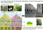
Image:Analytical Drawing of narrow street.jpg|Analytical drawing Narrow Alleys | Image:Analytical Drawing of narrow street.jpg|Analytical drawing Narrow Alleys | ||
Image:Analytic drawing from Interior Design background.jpg|analytical drawing shopping zone | Image:Analytic drawing from Interior Design background.jpg|analytical drawing shopping zone | ||
Image:fruit tree walk frist steeps. | Image:fruit tree walk frist steeps.png|analytical drawing river zone | ||
</gallery> | </gallery> | ||
| Line 68: | Line 68: | ||
<gallery caption="Projective Drawings " widths="150px" heights="150px" perrow="4"> | <gallery caption="Projective Drawings " widths="150px" heights="150px" perrow="4"> | ||
Image: | Image:Landshut_projective_drawing_3.jpg|projective drawing parking zone | ||
Image: | Image:Projective Drawing of narrow street.jpg|Projective Drawing Narrow Alleys | ||
Image:Projective drawing from Interior Design background.jpg|projective drawing shopping zone | Image:Projective drawing from Interior Design background.jpg|projective drawing shopping zone | ||
Image: | Image:Fruit-Tree.jpg|projective drawing river zone | ||
</gallery> | </gallery> | ||
| Line 78: | Line 78: | ||
<gallery caption="Design Synthesis Drawings" widths="150px" heights="150px" perrow="4"> | <gallery caption="Design Synthesis Drawings" widths="150px" heights="150px" perrow="4"> | ||
Image: | Image:Landshut Parking Design Synthesis.jpg|synthesis drawing parking zone | ||
Image: | Image:Design Synthesis Overall.jpg|Overall Design Synthesis | ||
Image: | Image:Design Synthesis shopping zone.png|synthesis drawing shopping zone | ||
Image:yourfilename4.jpg|synthesis drawing 4 | Image:yourfilename4.jpg|synthesis drawing 4 | ||
</gallery> | </gallery> | ||
== Summary of the collaborative process == | == Summary of the collaborative process == | ||
'' | ''The urban civilization and its degrading environment is a major problem for the city dwellers. The city has to bear the pressure of modernization and also exist in itself as it belongs to the past. Its identity is the main issue but a healthy environment for the people living in it cannot be sidelined. So it was a main challenge to design an existing city with its historic importance by making it a livable and healthy place for the public. The foremost idea developed was to do an overall planning for planting design throughout the city. But the same approach for all the area was not possible. So the design areas were separated in parts. And different approaches of design were taken for each part. | ||
So instead of working in the same design four times, we divided the work into four parts and in the process of designing, we discussed, synthesized and suggested each other for design processes. | |||
And collaboratively we came up with one synthesized design. We could learn a lot from each other’s educational background as well as culture. | |||
'' | |||
== Image Gallery == | == Image Gallery == | ||
| Line 98: | Line 101: | ||
Image:Single planting.png| one spartan existing try of planting | Image:Single planting.png| one spartan existing try of planting | ||
</gallery> | </gallery> | ||
== References for project "parking zone"== | |||
== References for project "narrow alleys"== | |||
* http://www.retrostructure.com/why-green-walls-and-algae-facades-work/ | |||
* http://www.houzz.com/photos/landscape/alley | |||
* http://en.wikipedia.org/wiki/File:Ivy-leaved_Toadflax.JPG | |||
* http://en.wikipedia.org/wiki/File:Vigne_vierge_(Parthenocissus_tricuspidata).jpg | |||
* http://en.wikipedia.org/wiki/File:Cymbalaria_muralis_close_up.jpg | |||
* http://en.wikipedia.org/wiki/File:Hedera_helix1.JPG | |||
== References for project "city zone"== | |||
* www.parks-und-gaerten.de | |||
* www.urbanophil.net | |||
* www.burolubbers.nl | |||
* sreet art by Démocratie Créative | |||
* www.maps.google.com | |||
* personal photographs | |||
== References for project "river zone"== | |||
---- | ---- | ||
[[Category: Planting Design 2013 Working Group]] | [[Category: Planting Design 2013 Working Group]] | ||
Latest revision as of 11:34, 11 February 2014
---> back to group page working group 14
| Name | Green City Development | |
| Location | Landshut | |
| Country | Germany | |
| Authors | greencitygroup | |

How to bring nature in city??? | ||
| <googlemap version="0.9" lat="48.535397" lon="12.153959" type="satellite" zoom="14" width="300" height="250" selector="no" controls="small">
</googlemap> | ||
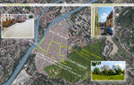
Landscape and/or urban context of your case
The increasing urbanization and associated green spaces displacement enhances the desire for more plants in the city centres. In several studies there was investigated that people can experience significant psychological improvements in greener cities. Green spaces improve the well-being, health and mental health of people in cities. The people in the town center of Landshut are still plagued by a green poverty, not only by urbanization, but especially by their history. Landshut is an old historical Bavarian city, located in the Isar valley at the beginning of a range of hills, embedded in the rural nature with forests, meadows and the river Isar. In 2004 , the city of Landshut was eight hundred years old. So Landshut has a medieval city center, which is nearby the river Isar and under the castle Trausnitz with the court garden. Formerly this park was the garden of the castle. Castles and monasteries have always had a vegetable garden with fruit trees, vegetables and wine. Basically medieval towns had very little green in the city center, because the center was only a place of action and sales. Thus cultivated plantings were reserved for the nobility or the monks. Gardens in city backyards were quite rare, too. Otherwise you could find agriculture outside the city. In the transition to modern times, the middle class got rid of the tutelage by the nobility and was culture- determining. So the court garden was formed in 1837 to a public park. However, new plantings in the town centre were very rare to obtain the characteristics of the medieval city.
-
 landscape and urban context

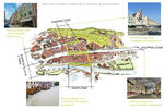
What are the objectives of your design?
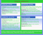
The common idea of the group was the development of a green space design concept based on the town Landshut. This concept includes four different views how a bare city could be planted. Initial situation was a green corridor within the city as a link between the natural areas river and court garden. The most plant species should be taken from the court garden or the river area. Based on the background knowledge of the individual group members and the starting situation there will be developed four different concepts.
-
 planning with different backgrounds

Analytical drawings
Please add four analytical sketches/drawings (or montages/schemes) of your case. Every group member needs to contribute at least one drawing.
- Analytical Drawings
-
 analytical drawing parking zone
 -
 Analytical drawing Narrow Alleys
 -
 analytical drawing shopping zone
 -
 analytical drawing river zone


Projective drawings
Please add four projective sketches/drawings (or montages/schemes), of course with an emphasis on planting design/vegetation aspects. Every group member needs to contribute at least one drawing representing his/her individual ideas.
- Projective Drawings
-
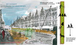
 projective drawing parking zone
 -
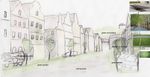
 Projective Drawing Narrow Alleys
 -
 projective drawing shopping zone
 -
 projective drawing river zone


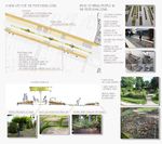
Design Synthesis
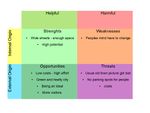
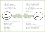
Please analyse the individual approaches presented so far and evaluate their strengths and weaknesses (you may use the SWOTanalysis model). Try to create a synthesis and represent it with a plan and some sketches. You can still use drawings/sketches.
- Design Synthesis Drawings
-
 synthesis drawing parking zone
 -
 Overall Design Synthesis
 -
 synthesis drawing shopping zone
 -
synthesis drawing 4


Summary of the collaborative process
The urban civilization and its degrading environment is a major problem for the city dwellers. The city has to bear the pressure of modernization and also exist in itself as it belongs to the past. Its identity is the main issue but a healthy environment for the people living in it cannot be sidelined. So it was a main challenge to design an existing city with its historic importance by making it a livable and healthy place for the public. The foremost idea developed was to do an overall planning for planting design throughout the city. But the same approach for all the area was not possible. So the design areas were separated in parts. And different approaches of design were taken for each part. So instead of working in the same design four times, we divided the work into four parts and in the process of designing, we discussed, synthesized and suggested each other for design processes. And collaboratively we came up with one synthesized design. We could learn a lot from each other’s educational background as well as culture.
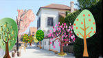
Image Gallery
You may add a series of images/photos in addition to the sketches/drawings
- Image Gallery
-
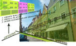
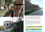
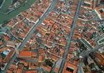 "stone city"
 -
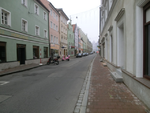 "narrow bare alleys"
 -
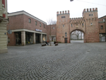
 "parking zone" dirty area because of exhaust emissions
 -
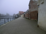 "river zone" often lifeless footpaths
 -
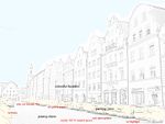
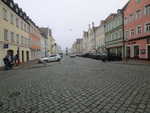
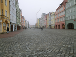 "shopping and pedestrian zone" 15 m whide street only used for crossing
 -
 one spartan existing try of planting


References for project "parking zone"
References for project "narrow alleys"
- http://www.retrostructure.com/why-green-walls-and-algae-facades-work/
- http://www.houzz.com/photos/landscape/alley
- http://en.wikipedia.org/wiki/File:Ivy-leaved_Toadflax.JPG
- http://en.wikipedia.org/wiki/File:Vigne_vierge_(Parthenocissus_tricuspidata).jpg
- http://en.wikipedia.org/wiki/File:Cymbalaria_muralis_close_up.jpg
- http://en.wikipedia.org/wiki/File:Hedera_helix1.JPG
.jpg)
References for project "city zone"
- www.parks-und-gaerten.de
- www.urbanophil.net
- www.burolubbers.nl
- sreet art by Démocratie Créative
- www.maps.google.com
- personal photographs