Group M - Collaborative Climate Adaption Project: Difference between revisions
Janice Thien (talk | contribs) |
Janice Thien (talk | contribs) |
||
| (97 intermediate revisions by 2 users not shown) | |||
| Line 38: | Line 38: | ||
We have selected this area out of our concern for those who will feel the affects of climate change first, and are representative of those who may endure the most significant impacts of climate change and sea level rise. For our project focus, we have selected an island known as ''Iama'' or ''Yam island''. It is a part of the Torres Strait, an archipelago of islands between the Northern tip of Australia and Papua New Guinea. Politically, the islands are a part of Australia, however they are culturally distinct being a traditional Pacific Islander culture, with strong links to the traditional cultures of northern Australia and Papua New Guinea. The islanders have a specific vulnerability to climate change being a strongly sea based culture and living very much between the sea and the land. Subtle changes in sea levels and oceanic conditions (such as acidification) will have large and far reaching impacts into the islanders life, cultural orientation and livelihoods that will only become more pronounced as these changes become more drastic. Climate change may also bring more severe storm conditions via larger cyclonic tropical depressions. The communities of the Torres Strait, as indigenous people of these islands, face a host of issues concerning sovereignty and ownership rights of land due to Australian Government Policy. In addition Torres Strait Community members are significantly affected by conditions of Diabeties and Heart Disease attributed to the uptake of Western dietary choices over Traditional foods. We are particularly interested in this area as a program of adaption to climate change could have a "No Regrets" approach of also improving the preexisting health and land rights policy conditions faced by islanders. There has been some significant research into the impacts of climate change on the Torres Strait, including our project focus area of Iama Island. This research is ongoing however much of the work is predominantly taken from the perspective of setting minimum building floor levels and providing engineered infrastructure such as Sea Walls. Whilst these are significant foundations, we believe an approach from Landscape Architecture that considers settlement patterns, cultural and physical wellbeing will provide a more thorough approach towards a continuing, resilient Torres Strait Island Culture. | We have selected this area out of our concern for those who will feel the affects of climate change first, and are representative of those who may endure the most significant impacts of climate change and sea level rise. For our project focus, we have selected an island known as ''Iama'' or ''Yam island''. It is a part of the Torres Strait, an archipelago of islands between the Northern tip of Australia and Papua New Guinea. Politically, the islands are a part of Australia, however they are culturally distinct being a traditional Pacific Islander culture, with strong links to the traditional cultures of northern Australia and Papua New Guinea. The islanders have a specific vulnerability to climate change being a strongly sea based culture and living very much between the sea and the land. Subtle changes in sea levels and oceanic conditions (such as acidification) will have large and far reaching impacts into the islanders life, cultural orientation and livelihoods that will only become more pronounced as these changes become more drastic. Climate change may also bring more severe storm conditions via larger cyclonic tropical depressions. The communities of the Torres Strait, as indigenous people of these islands, face a host of issues concerning sovereignty and ownership rights of land due to Australian Government Policy. In addition Torres Strait Community members are significantly affected by conditions of Diabeties and Heart Disease attributed to the uptake of Western dietary choices over Traditional foods. We are particularly interested in this area as a program of adaption to climate change could have a "No Regrets" approach of also improving the preexisting health and land rights policy conditions faced by islanders. There has been some significant research into the impacts of climate change on the Torres Strait, including our project focus area of Iama Island. This research is ongoing however much of the work is predominantly taken from the perspective of setting minimum building floor levels and providing engineered infrastructure such as Sea Walls. Whilst these are significant foundations, we believe an approach from Landscape Architecture that considers settlement patterns, cultural and physical wellbeing will provide a more thorough approach towards a continuing, resilient Torres Strait Island Culture. | ||
Members of our group have had experience in strategising for | Members of our group have had experience in strategising for sea level rise and local experience of working in the Torres Strait. | ||
=== Authors' perspectives === | === Authors' perspectives === | ||
| Line 49: | Line 49: | ||
The Torres Strait islands (TSI) were formed through mostly volcanic activity that formed the original landscapes of Northern Australia and Papua New Guinea (PNG). The Islands were originally a land bridge between PNG and Australia and over time, from erosive pressures of oceanic tidal currents, and previous changes in Sea levels, what was land, became sea and reef. Interestingly, Torres Strait Islands has been formed most noticeably through changes in sea level rise following the last ice age. The Island communities are closely related to Melanesia and Papua New Guinean Cultures, with some influence from Northern Australian Aboriginal Culture. They are predominantly a seafaring people, with food, transport, cultural stories, trade and family groups and settlement patterns defined by relationships with the sea. The Tribal cultures of Papua New Guinea and Melanesia appear to have a dominant historical influence on cultural paradigms, however these have evolved into a distinctly regional culture based on the islands. The Torres Strait Islanders have land use patterns both in common with PNG, Pacific Islander Culture and Australian Aboriginal cultures. Food production is both agricultural and hunted or wild harvested, however much food is imported from Australia and now forms a significant part of TSI diets. Settlement patterns are based on village structures by the sea, yet temporary seasonal camps serve food harvesting purposes on either other islands or on more remote parts of settled islands. Settlement patterns now have been heavily influenced by western style housing and suburban settlement patterns, however traditional style improvised shelters for gathering and recreation continue to be constructed and decorated from both traditional and modern reused construction materials. Islands are predominantly bushland with small areas set aside amongst housing for subsistance gardening, which is now practiced less and less. Small urban clusters now occupy small village sites, with larger blocks of housing surrounding the central village areas. Social hubs tend to be around sea ports and wharfs where people launch to the sea, arrive home to meet family or spend time fishing. | The Torres Strait islands (TSI) were formed through mostly volcanic activity that formed the original landscapes of Northern Australia and Papua New Guinea (PNG). The Islands were originally a land bridge between PNG and Australia and over time, from erosive pressures of oceanic tidal currents, and previous changes in Sea levels, what was land, became sea and reef. Interestingly, Torres Strait Islands has been formed most noticeably through changes in sea level rise following the last ice age. The Island communities are closely related to Melanesia and Papua New Guinean Cultures, with some influence from Northern Australian Aboriginal Culture. They are predominantly a seafaring people, with food, transport, cultural stories, trade and family groups and settlement patterns defined by relationships with the sea. The Tribal cultures of Papua New Guinea and Melanesia appear to have a dominant historical influence on cultural paradigms, however these have evolved into a distinctly regional culture based on the islands. The Torres Strait Islanders have land use patterns both in common with PNG, Pacific Islander Culture and Australian Aboriginal cultures. Food production is both agricultural and hunted or wild harvested, however much food is imported from Australia and now forms a significant part of TSI diets. Settlement patterns are based on village structures by the sea, yet temporary seasonal camps serve food harvesting purposes on either other islands or on more remote parts of settled islands. Settlement patterns now have been heavily influenced by western style housing and suburban settlement patterns, however traditional style improvised shelters for gathering and recreation continue to be constructed and decorated from both traditional and modern reused construction materials. Islands are predominantly bushland with small areas set aside amongst housing for subsistance gardening, which is now practiced less and less. Small urban clusters now occupy small village sites, with larger blocks of housing surrounding the central village areas. Social hubs tend to be around sea ports and wharfs where people launch to the sea, arrive home to meet family or spend time fishing. | ||
This Map [http://www.google.com.my/imgres?um=1&hl=en&sa=N&tbo=d&biw=1366&bih=705&tbm=isch&tbnid=kc3AkrENIO7BvM:&imgrefurl=http://torresstraitclimate.org/the-region-and-its-people/&docid=w119U2tk9TAhWM&imgurl=http://torresstraitclimatedotorg.files.wordpress.com/2011/05/annika_torres-strait-map11.png&w=3054&h=1934&ei=TcnzUIbCGMixkgWWlYGIBw&zoom=1&iact=rc&dur=4&sig=115660871284287683847&page=1&tbnh=141&tbnw=222&start=0&ndsp=26&ved=1t:429,r:18,s:0,i:135&tx=90&ty=59] shows the regional island groups, which islands are occupied and the group of island (including our project location) where islands are predominantly mangrove or coral cays close to sea level. | |||
The Photos below are Sketches made of the islands showing the nature of the landscape and lifestyle of people. They show that the landscape is in the Dry tropics and characterised by rocky volcanic islands, and dry tropic vegetation. Rainforest environments are found only in small rocky valleys, however rainforest plants persist amongst the dominant savannah landscapes due to the monsoonal wet-dry seasonality. | |||
All photos and drawings in the below section were done by James Nash (co -author) | |||
<gallery caption=" " widths="400px" heights="400px" perrow="5"> | <gallery caption=" " widths="400px" heights="400px" perrow="5"> | ||
| Line 74: | Line 71: | ||
Image:Sea wall, transport and sea decorations.jpg| | Image:Sea wall, transport and sea decorations.jpg| | ||
</gallery> | </gallery> | ||
===Case study site: Iama Island=== | ===Case study site: Iama Island=== | ||
| Line 88: | Line 84: | ||
<gallery caption=" " widths="500px" heights="500px" perrow="5"> | <gallery caption=" " widths="500px" heights="500px" perrow="5"> | ||
Image:Iama | Image:Iama map.jpg| Reconstructed map (''by Janice Thien'') based on information at Iama Sustainable Land Use [http://www.tsra.gov.au/__data/assets/pdf_file/0010/2026/08-iama-slup.pdf] | ||
</gallery> | </gallery> | ||
The community resides at the northwestern end of the Island, of flatland with an area of 300mx300m. The flat terrain rises to 1.5 meter above sea level, and is susceptible to sea level rise. The | The community resides at the northwestern end of the Island, of flatland with an area of 300mx300m. The flat terrain rises to 1.5 meter above sea level, and is susceptible to sea level rise. The village is located between the air strip and the barge ramp towards the northwestern coastline. The residential area consists of dwellings, primary school, churches, council offices and workshop, and store. | ||
The above information on Iama Island is extracted from Iama Sustainable Land Use [http://www.tsra.gov.au/__data/assets/pdf_file/0010/2026/08-iama-slup.pdf] | |||
The population maintains steadily around 340 residents (174 in 1998) for the past 10 years, with a density of 198.7 persons per kilometre square. The 2006 census shows that the average age of the population is 20 years, 40.1% of the population were under 15 years old. | The population maintains steadily around 340 residents (174 in 1998) for the past 10 years, with a density of 198.7 persons per kilometre square. The 2006 census shows that the average age of the population is 20 years, 40.1% of the population were under 15 years old. | ||
Survey done by Australian Bureau of Statistics had a result showing that of the 133 people in employment in 2006, 111 people (83%) were in Public Administration and Safety Sector. This trend is seen across the overall Torres Strait Region, from the survey done in 2006, at least 70% of employment is in the Public Administration and Safety Sector, the remaining employment proportion are mainly distributed among retail, education and training, healthcare and social assistance. | |||
Torres Strait is a busy shipping lane, members of the communities work regularly as pilots for shipping vessels having expert knowledge of the area. This, in addition to local government employment could explain the high number of employees in Public Admin. Not one member of the island is employed in construction, and further, only three in education- presumably childcare. This would significantly impact on the skills basis for local adaptive measures to be skilfully delivered by the islands residents- at least in a supervisory role. | |||
=== Cultural/social/political context=== | === Cultural/social/political context=== | ||
| Line 118: | Line 102: | ||
The Torres Strait is politically part of Australia and is the birthplace of native title law. Torres Strait Islanders are a separate people in origin, history and way of life than the mainland Australia aboriginal people. They now live in 18 communities on 17 islands. The Islanders were fishermen, hunters and agriculturalists and are fearless defenders of their territories and cultures. Each community is distinct, having their own traditions, laws and customs. | The Torres Strait is politically part of Australia and is the birthplace of native title law. Torres Strait Islanders are a separate people in origin, history and way of life than the mainland Australia aboriginal people. They now live in 18 communities on 17 islands. The Islanders were fishermen, hunters and agriculturalists and are fearless defenders of their territories and cultures. Each community is distinct, having their own traditions, laws and customs. | ||
This image [http://www.google.com.my/imgres?um=1&hl=en&sa=N&tbo=d&biw=1366&bih=705&tbm=isch&tbnid=6ySmdM04RK7FxM:&imgrefurl=http://www.couriermail.com.au/ipad/performers-mark-coming-of-the-light/story-fn6ck51p-1226085146869&docid=eD6MfH44EbiawM&imgurl=http://resources2.news.com.au/images/2011/06/30/1226085/146662-torres-strait-islanders-performing.jpg&w=650&h=366&ei=18nzUM64IIfQlAWgioCAAw&zoom=1&iact=hc&vpx=668&vpy=374&dur=1967&hovh=168&hovw=299&tx=145&ty=108&sig=115660871284287683847&page=3&tbnh=144&tbnw=274&start=58&ndsp=33&ved=1t:429,r:88,s:0,i:351] shows Torres Strait Islander performing their traditional dance. | |||
Torres Strait islanders have had some contact with outside influences and traders for centuries, including Chinese, Dutch and Portuguese explorers and traders in addition to Pacific Islander traders and explorers. From settlement in the late 19th century by colonising European cultures, traditional Torres Strait Islander society was changed by the discovery of commercial quantities of pearlshell, arrival of Christian missionaries, and all islands being legally annexed to the Colony of Queensland by 1879. In the 1980s and 1990s, Eddie Mabo- A Torres Strait Islander, challenged the Australian Government in the high court of Australia over the Australian constitutional recognition of indigenous occupation of lands prior to European settlement. He succeeded in his challenge and the Australian constitution was changed to recognise Indigenous occupation. Torres Strait Islanders were the first Indigenous Australians to be granted local self-governence. Their efforts have influenced Australian laws regarding Indigenous land tenure, and they are still working on protecting their land and sea rights. | Torres Strait islanders have had some contact with outside influences and traders for centuries, including Chinese, Dutch and Portuguese explorers and traders in addition to Pacific Islander traders and explorers. From settlement in the late 19th century by colonising European cultures, traditional Torres Strait Islander society was changed by the discovery of commercial quantities of pearlshell, arrival of Christian missionaries, and all islands being legally annexed to the Colony of Queensland by 1879. In the 1980s and 1990s, Eddie Mabo- A Torres Strait Islander, challenged the Australian Government in the high court of Australia over the Australian constitutional recognition of indigenous occupation of lands prior to European settlement. He succeeded in his challenge and the Australian constitution was changed to recognise Indigenous occupation. Torres Strait Islanders were the first Indigenous Australians to be granted local self-governence. Their efforts have influenced Australian laws regarding Indigenous land tenure, and they are still working on protecting their land and sea rights. | ||
The TSRA (Torres Strait Regional Authority) is established on 1 July 1994 in response to local demands for greater autonomy, to manage their affairs based on their own island customs. The region has its own flag signifying unity and identity of the different groups of islanders. The government agencies are based on Thursday Island, the administrative centre for Torres Strait region. | The TSRA (Torres Strait Regional Authority) is established on 1 July 1994 in response to local demands for greater autonomy, to manage their affairs based on their own island customs. The region has its own flag signifying unity and identity of the different groups of islanders. The government agencies are based on Thursday Island, the administrative centre for Torres Strait region. The organisational chart can be viewed at [http://www.tsra.gov.au/__data/assets/pdf_file/0006/3021/TSRA-Organisational-Chart-2012-2-Colour.pdf] | ||
The existence, condition and management of the natural environment is fundamental to the livelihood of the Iama Island community, and Torres Strait Islanders in general. The natural environment includes animals, coastline, tides and storm surges, waterways and wetlands, land and soil, and bushfire. These must be part of all decisions and plans. The well being of the natural environment is crucial for community health and its close association with cultural significant activities. | The existence, condition and management of the natural environment is fundamental to the livelihood of the Iama Island community, and Torres Strait Islanders in general. The natural environment includes animals, coastline, tides and storm surges, waterways and wetlands, land and soil, and bushfire. These must be part of all decisions and plans. The well being of the natural environment is crucial for community health and its close association with cultural significant activities. | ||
=== Local Climate === | === Local Climate === | ||
| Line 153: | Line 126: | ||
The Torres Strait Islands region is subject | The Torres Strait Islands region is subject to cyclonic systems which bring destructive winds and high seas, posing threats to low-lying islands including Iama Island. Due to the close proximity to the equator, the cyclonic forces are weaker than further away however they still create significant impacts on the island. The Islanders’ cultures, societies and economies rely heavily on the ecosystem. In 2005 and 2006, a number of the islands were subject to king tides and had lives threatened and damage caused. Major expected impacts of climate change will be from warmer temperature stress, rising seas, increased frequency of extreme weather events, and oceanic acidification. Visible changes due to climate change are increased erosion, strong winds, land accretion, increasing storm frequency and rougher seas that elders have never encountered before. | ||
These events have caused impacts on the number of turtles nesting and altered birds’migration patterns. Dugongs (sea cow) that are traditionally hunted for meat have become scarce. | These events, considered emerging evidence of early climate change have caused impacts on the number of turtles nesting and altered birds’migration patterns. Dugongs (sea cow) that are traditionally hunted for meat have become more scarce. Gardeners are less certain when to plant their crops due to seasons shifting. Climatic conditions feature strongly in Torres Strait Island spiritual belief systems- including names and qualities of seasonal winds, and significance of ocean currents and climatic events such as Water Spouts. The current shifting nature of climate may therefore have some significant cultural/ spiritual impacts. Their ways of life are threatened both physically by climate change effects on the local environment, and culturally by ongoing issues of westernisation and policy and governance. How the Torres Strait islanders adapt to these changes will determine the long term survival and integrity of their culture. | ||
Image [http://www.google.com.my/imgres?um=1&hl=en&tbo=d&biw=1366&bih=705&tbm=isch&tbnid=eqxvN3JHC1lthM:&imgrefurl=http://humanrights.gov.au/social_justice/nt_report/ntreport08/Climate_Change_Community_Guide.html&docid=I2CDj58vOfgHOM&imgurl=http://humanrights.gov.au/social_justice/nt_report/ntreport08/images/cg_pic3.jpg&w=480&h=357&ei=xPrzUJWcGc7PkAW81YHoBQ&zoom=1&iact=hc&vpx=4&vpy=126&dur=4829&hovh=194&hovw=260&tx=139&ty=75&sig=115660871284287683847&page=1&tbnh=137&tbnw=185&start=0&ndsp=26&ved=1t:429,r:0,s:0,i:78] showing King tide invasion of Iama Island. | |||
Illustration: Table or time line | Illustration: Table or time line | ||
| Line 171: | Line 141: | ||
Climate Change Direct Impact: | Climate Change Direct Impact: | ||
* Inundation and destruction towards public facilities, settlement and sewage | * Inundation and destruction towards public facilities, Housing, settlement and sewage systems | ||
*Inundation and salination of fertile soils that provide for food production | |||
* Degradation of significant cultural sites such as burial and sacred grounds, hunting and gathering places. | * Degradation of significant cultural sites such as burial and sacred grounds, hunting and gathering places. | ||
* Change in coral growth/coral bleaching | * Change in coral growth/coral bleaching fish and crustacean habitats, diminished sea food resources | ||
| Line 185: | Line 157: | ||
* Flooding of above ground rubbish tips and and existence of standing water increase the spread of diseases | * Flooding of above ground rubbish tips and and existence of standing water increase the spread of diseases | ||
* Increase in living expenses due to increase in fuel and travel cost. | * Increase in living expenses due to increase in fuel and travel cost. | ||
| Line 192: | Line 162: | ||
* Changes in traditional hunting and cultural practices | * Changes in traditional hunting and cultural practices | ||
* | * Emergence of refugees between borders, putting on population pressure | ||
* Some islands may disappear completely or lose large area of land, forcing relocation and dispossession | |||
=== Proposals for Climate Change Adaption === | === Proposals for Climate Change Adaption === | ||
| Line 210: | Line 172: | ||
- Please describe 2-3 measures | - Please describe 2-3 measures | ||
1. Infrastructure adaptation: | |||
*New collective housing community that is set with floor levels higher than prediced levels of inundation. Where inundation is unavoidable, housing is either removed or usage and design modified to cope with inundation. | |||
*Restoration of sea shore habitats around coastal areas including mangrove, saltmarsh and dune systems for mitigation of sea rise impacts is given priority. Seawalls and bunds may be repaired or improved where they are effective, however these infrastructures tend to shift erosion to other areas, and worse, create a false sense of security for constructions behind the sea wall thus increasing vulnerability. Offshore protection could include establishment of artificial reefs for the establishment of enhanced local fisheries. In addition, reefs modify the velocity of storm surges and the force induced destructive potential. Structures are modified to cope more efficiently with water inundation where this may occur. | |||
*Examine alternative means of power and energy creation based on wind energy, tidal or wave energy, solar or solar thermal. Investigate existing examples of these technologies: particularly tidal energy given the extremes of tides in the Torres Strait and the traditional cultural paradigms of harnessing the seas 'power'. This strategy will both reduce the economic burden of escalating energy costs, and simultaneously reduce carbon emissions | |||
*Introducing Reef Ball, a marine breakthrough: | |||
Reefballs are designed to create sealife habitat, prevent erosive forces of waves and protect onshore assets from coastal erosion. They worked very well when used in a high number of modules. They would be well suited to Iama island for assisting in the protection of island resources. These designed artificial reef modules are able to last against sea forces and do not erode/breakdown easily. The biggest expense is getting the reefs into the sea. It Is worth investigating the possibility of engineering reefballs on Iama Island to reduce the cost of transport. This would involve the transport of raw materials- concrete and moulds, however this could be cheaper in the long term than purchasing them off shore. This could become a marine reserve at a bigger scale, and possibly a sustainable tourism industry. | |||
Image of reefball can be viewed here [http://www.google.com.my/imgres?um=1&hl=en&sa=N&tbo=d&biw=1366&bih=705&tbm=isch&tbnid=m9UTuFPF_nMk2M:&imgrefurl=http://www.reefball.org/brochure.htm&docid=FsT0n2ar5yli2M&imgurl=http://www.reefball.org/newfrontpage/smallsizes.jpg&w=480&h=372&ei=qNTzUIaNIMO1kgWvroGYBQ&zoom=1&iact=hc&vpx=4&vpy=381&dur=583&hovh=198&hovw=255&tx=140&ty=124&sig=115660871284287683847&page=1&tbnh=141&tbnw=190&start=0&ndsp=28&ved=1t:429,r:21,s:0,i:150] | |||
* Risk assessment and disaster management | Fore more information, please view Reef Ball Foundation website [http://www.reefball.org/]. | ||
2. Explore alternative livelihood options and income sources | |||
* Gain resources for resilience measures and to be as self sufficient as possible in terms of food sources. | |||
*Revival of traditional management practice of natural resources should be encouraged to ensure food affordability and security. | |||
Two types of productive landscapes can be established. First is communal food garden in easy reach of the houses for community food growing, to experiment with new ideas and for education opportunities. | |||
Second type is bush garden, cultivate/produce staple food at bigger scale further from home and can be done on steeper land. | |||
The gardens are to be built with natural resources and bush materials including native bamboo, and use of natural fertilisers from fish waste and chicken manure. This project can enhance sense of community living, encourage exchange of food, seeds, and materials. In addition it could have a huge impact on the pressing need of reducing waste through reducing the reliance on packaged foods, and recycling generated food wastes. | |||
*Chicken pens within the village and forest style: chicken forage runs can be built to have meat and eggs in production within the natural environment within close proximity to the village. | |||
<gallery caption=" " widths="500px" heights="500px" perrow="5"> | |||
Image:iama section.jpg| Section showing community utilising spaces between dwellings for food growing.(''by Janice Thien'') | |||
</gallery> | |||
*Aspects to consider about food growing | |||
- Soil type and quality | |||
- Availability of seeds, planting materials and knowledge | |||
- Land ownership and landuse tradition. | |||
-Predation on poultry from Cats/ Dogs | |||
'''Precedent: SUSTAINABLE AGRICULTURE - Prefabricated Modular Sustainable Housing - (Marigot, St. Martin)''' | |||
View at [http://cargocollective.com/uplift/THESIS] | |||
Start by introducing '''Continuous Productive Urban Landscape (CPUL)''', a strategy interlinking pockets of spaces for food growing, redefining the usage of leftover and underused urban spaces.The urban food benefits more than personal well being and community enjoyment. Its social, economic, environmental and spatial relevance form complex and integrative relationships for urban sustainability. | |||
<gallery caption=" " widths="600px" heights="600px" perrow="5"> | |||
Image:foodmap.jpg| Reconstructed diagram (''by Janice Thien'') based on urban food system by Bohn&Viljoen Architects (2002) found at The Edible City: Envisioning the Continuous Productive Urban Landscape (CPUL)[[http://www.field-journal.org/uploads/file/2011%20Volume%204/10%20The%20Edible%20City%20Katrin%20Bohn%20and%20Andre%20Viljoen.pdf] | |||
</gallery> | |||
3. Risk assessment and disaster management plans need to be incorporated and consistently reviewed and improved. Involve the community of Iama as much as possible in this process. Lower lying island communities such as Iama need planning for worst case scenario of sea level rise and how to manage the aftermath. Disaster management plans for the present to immediate future- specifically for storm surges are key in developing a strategy towards long term climate change adaption for sea level rise. Capacity building of community to prepare for storm surges as a potential disaster are like a 'dress rehearsal' for more permanent sea level rise. It is clear that infrastructure development required for disaster mitigation now, and addressing underlying issues of social and cultural vulnerability could be of great benefit for adaption to sea level rise later. These processes may include Items 1 and 2 above and in addition, scoping potential settlement and urban planning locations for the village. This process has been proposed by independent consultants, however concept planning and proposals for shifts in this direction have not yet been made. | |||
=== Proposals for Climate Change Mitigation === | === Proposals for Climate Change Mitigation === | ||
-Which measures would need to be taken to reduce greenhouse gas emissions and other drivers of climate change within your case study area? How could you assure sustainability of these measures? Please describe 2-3 measures | -Which measures would need to be taken to reduce greenhouse gas emissions and other drivers of climate change within your case study area? How could you assure sustainability of these measures? Please describe 2-3 measures | ||
* Promote harvesting water locally and water recycling, waste reduction, and community garden initiatives to reduce carbon footprints and food miles. | 1.Sustainable use of Water and Food resources | ||
*Promote harvesting water locally and water recycling, and low carbon/ energy intensive water desalination technologies, Solar water heating technologies waste reduction, and community garden initiatives to reduce carbon footprints and food miles. Use of bulk foods shopping only for island shop with no/ Paper only packaging on products. Introduction of appropriate water use practices and technologies, change in washing and cleaning practices. Waste water and storm water is collected and treated, cleaned, processed, and recycled for irrigation. The solid parts of the waste water can be processed into compost and fertilisers for bamboo groves for construction materials. | |||
* '''Precedent: Composting Toilet at Fiji Island''' | |||
by AES (Architectural Environmental Strategies) based in Stockholm, Sweden. Please view [http://architecturalenvironmentalstrategies.wordpress.com/niubasaga-nimataka/] | |||
* Water desalination powered by offshore wind turbine example as shown here [http://www.archdaily.com/12956/zira-island-carbon-neutral-master-plan-big-architects/energy-circle/] | |||
These technologies could be modified to be cultural and social symbol of the islands sustainability. | |||
2. Increase transport efficiency, encourage sustainable way of transport, walking, cycling- Given the islands size, cars are not really a necessary element on the island- investigate smaller powered vehicles for any motorised transport. This would reduce the load on island paths and road infrastructure. Encourage the use of paddled sea craft as per tradition as an alternative to small powered watercraft. The Airport Strip Is currently a large proportion of habitable area of the island. Investigations of the main users of the airport and air service may be helpful to determine the long term viability of this service. Currently there are three flights per day from the island which seems excessive for an Island of this population. Could this number of flights be reduced and condensed into 3-5 flights per week? | |||
3. Application of an island green building code that specifies passive solar design, shade, and utilises insulation and ventilation as atmospheric cooling devices. Recommends the reclaim and reuse materials as much as possible, In addition to using locally available waste building materials to create resilient structures. This could include utilising shipping containers as a building material (see http://www.cargotecture.com for examples of these options.) Explore possibilities of working at a bigger scale into Regional Waste Strategy that addresses building materials. A building code could have the potential of reducing dependancy on fossil fuels used for air conditioning, lighting and water heating/ pumping. | |||
4. Reducing dependancies on fossil fuels will reduce the carbon footprint and other greenhouse gasses of the islanders and therefore mitigate the promotion of the greenhouse effect, pushing up global temperatures. Given the small size and population of the island, electricity production from diesel generators (their current electricity source) is particularly carbon intensive per capita. This may be off set by minimal car use and small engine/ boat use however changes to electricity generation would be an achievable and high impact change for the purposes of mitigation. To this end, there is a need to examine alternative means of power and energy creation based on wind energy, tidal or wave energy, solar or solar thermal. Investigate existing examples of these technologies: particularly tidal energy given the extremes of Tides in the Torres Strait and the traditional cultural paradigms of harnessing the seas 'power' . | |||
=== Your scenario === | === Your scenario === | ||
-How will this area look like in 2060? Please forecast one potential future development taking climate change into account | |||
The main concern on Iama Island from climate change will be sea level rise. The predicted levels are hard to clarify with variable research, however we will be working with a level of 0.5 metre, with more frequent storm surges (also induced by climate change) causing inundation of a significant proportion of what was once dry land. We have proposed a staged approach. | |||
'''2013- 2020 (7 years)''' | |||
*Begin retreat, modification of structures for camping usage and revegetation of sand spit on the shoreline. | |||
*Mangrove habitat saltmarsh and dune restoration. | |||
*Integrate habitat restoration with 'seawall' restoration- This means NOT using traditional seawalls but rather modifying the topography to the height of seawalls and including habitat as a protective boundary to buffer sea velocity. | |||
*Prioritise community education around construction techniques for the community to use for adaptation | |||
*Education around waste reduction and modification of patterns of consumption for minimising waste | |||
*Assess where water incurs into the community areas and buffer in a similar way | |||
*Commence food gardens program. | |||
*Review Disaster management planning to incorporate adaptive measures for climate change and associated sea level rise | |||
*Assess housing within the village to be retrofitted and housing to be raised/removed and replaced accounting for the needs of increased density and population. | |||
*Commence planning new communal village area at Gaurab create options study for village | |||
*Commence reefball prototyping and test in situ as artificial reefs for sea calming devices. | |||
*Commence construction of sea drainage street features- swale channels and vegetated drains. | |||
*Water tanks/ solar power/ flood proof composting toilets installed | |||
'''2020-2040 (20 years)''' | |||
-Continue with above projects- reefballs,food gardens, drainage, mangrove and dune maintenance and establishment | |||
*Retrofitting raising, and replacing susceptible housing continues within existing village | |||
*Commence and complete construction of Gaurab section with relocatable prefabricated housing | |||
*Construction of new energy infrastructure that has relocatable facility. | |||
*Construction of energy efficient desalination plant. | |||
*Community leads construction efforts for reefs and sea shore infrastructure. | |||
'''2040-2060 (20 years)''' | |||
*Expertise is exported to other islands | |||
*Continued efforts with above projects and through community based resources and education, works are able to be be planned and led by community members. | |||
*Community members are able to facilitate disaster management planning and incorporate these into long term climate change and sea level rise plans. | |||
=== What can be generalized from this case study? === | === What can be generalized from this case study? === | ||
-Are there any important theoretical insights? | -Are there any important theoretical insights? | ||
* Social and economic | |||
* Social and economic disadvantages such as lack of infrastructure, health services and employment opportunities reduce capacity of the community to adapt to climate change, making their lives and culture more vulnerable. | |||
* Climate change can be a direct threat to the rights of communities, such as the rights of food, health, culture, and healthy environment. | * Climate change can be a direct threat to the rights of communities, such as the rights of food, health, culture, and healthy environment. | ||
| Line 240: | Line 312: | ||
-Which research questions does it generate? | -Which research questions does it generate? | ||
* There has been immense effort carried out for research and planning, but how much of these strategies are being taken into action? what are the obstacles? Funding | * There has been immense effort carried out for research and planning, but how much of these strategies are being taken into action? what are the obstacles? Funding resources, human rights and sociopolitical reasons seem to be the issue. | ||
-Short statement plus background notes | -Short statement plus background notes | ||
| Line 248: | Line 320: | ||
<gallery caption=" " widths="150px" heights="150px" perrow="3"> | <gallery caption=" " widths="150px" heights="150px" perrow="3"> | ||
Image: | Image:Mslide1.jpg|Slide One | ||
Image: | Image:Mslide2.jpg|Slide Two | ||
Image: | Image:Mslide3.jpg|Slide Three | ||
</gallery> | </gallery> | ||
| Line 288: | Line 360: | ||
9. Community Vulnerability and Adaptation to Climate Change Assessment Report [http://www.mnre.gov.ws/documents/projects/climate/CIDA/Samoa%20CVA%20Report.pdf] | 9. Community Vulnerability and Adaptation to Climate Change Assessment Report [http://www.mnre.gov.ws/documents/projects/climate/CIDA/Samoa%20CVA%20Report.pdf] | ||
10. Managing Mangroves for Resilience to Climate Change, by IUCN [http://data.iucn.org/dbtw-wpd/edocs/2006-041.pdf] | |||
11. Water Management on Islands – Common Issues and Possible Actions [http://www.utwente.nl/mb/cstm/reports/downloads/watermanagement_on_islands.pdf] | |||
12. The Edible City: Envisioning the Continuous Productive Urban Landscape (CPUL)[http://www.field-journal.org/uploads/file/2011%20Volume%204/10%20The%20Edible%20City%20Katrin%20Bohn%20and%20Andre%20Viljoen.pdf] | |||
13. Climate Change and Human Rights of Torres Strait Islanders [http://www.humanrights.gov.au/social_justice/nt_report/ntreport08/pdf/casestudy1.pdf] | |||
---- | ---- | ||
[[Category:Climate Change Case Study]] | [[Category:Climate Change Case Study]] | ||
About categories: You can add more categories with this tag: "[[Category:Category Name]]", add your categories | About categories: You can add more categories with this tag: "[[Category:Category Name]]", add your categories | ||
Latest revision as of 18:00, 14 January 2013
| Area | Torres Strait Islands | |||||||||||
| Place | Iama Island (photo source: [3]) | |||||||||||
| Country | Australia | |||||||||||
| Topic | Sea level rise | |||||||||||
| Author(s) | James Nash, Aura Istrate, Janice Thien | |||||||||||

| ||||||||||||
| {{#widget:GoogleMaps | width=300 | height=200 | lat=-9.9026 | lng=142.7750 | zoom=11 | centermarker=yes | maptypecontrol=yes | overviewmapcontrol=yes | largemapcontrol=yes | scalecontrol=yes
}} | ||
Rationale: Why have you selected this case study area?
- Please summarise:- e.g. previous experience, is it your everyday environment?, specific vulnerability, previous research being done etc.
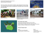
We have selected this area out of our concern for those who will feel the affects of climate change first, and are representative of those who may endure the most significant impacts of climate change and sea level rise. For our project focus, we have selected an island known as Iama or Yam island. It is a part of the Torres Strait, an archipelago of islands between the Northern tip of Australia and Papua New Guinea. Politically, the islands are a part of Australia, however they are culturally distinct being a traditional Pacific Islander culture, with strong links to the traditional cultures of northern Australia and Papua New Guinea. The islanders have a specific vulnerability to climate change being a strongly sea based culture and living very much between the sea and the land. Subtle changes in sea levels and oceanic conditions (such as acidification) will have large and far reaching impacts into the islanders life, cultural orientation and livelihoods that will only become more pronounced as these changes become more drastic. Climate change may also bring more severe storm conditions via larger cyclonic tropical depressions. The communities of the Torres Strait, as indigenous people of these islands, face a host of issues concerning sovereignty and ownership rights of land due to Australian Government Policy. In addition Torres Strait Community members are significantly affected by conditions of Diabeties and Heart Disease attributed to the uptake of Western dietary choices over Traditional foods. We are particularly interested in this area as a program of adaption to climate change could have a "No Regrets" approach of also improving the preexisting health and land rights policy conditions faced by islanders. There has been some significant research into the impacts of climate change on the Torres Strait, including our project focus area of Iama Island. This research is ongoing however much of the work is predominantly taken from the perspective of setting minimum building floor levels and providing engineered infrastructure such as Sea Walls. Whilst these are significant foundations, we believe an approach from Landscape Architecture that considers settlement patterns, cultural and physical wellbeing will provide a more thorough approach towards a continuing, resilient Torres Strait Island Culture. Members of our group have had experience in strategising for sea level rise and local experience of working in the Torres Strait.
Authors' perspectives
- What theoretical or professional perspective do you bring to the case study?
We will bring the perspective of cultural inclusiveness. We believe that the best way to work with cultures older than our own is to ask, listen, observe, learn- be guided by cultural knowledge, and then propose ideas. We will seek to understand existing regionally specific research into the effects of climate change in the Torres Strait, both widely, and on our specific project location. We will also seek to gain as much traditional knowledge about food production and harvesting technologies, transport patterns and navigation, settlement patterns and building technologies, and traditional systems of organising and local governance. We understand that much harm and damage has occured in Australian Indigenous communities through well intentioned, yet misguided development projects and we aim to take a different approach- allowing community cultural based patterns take precedence over proposals from architectural, engineering or policy based development. We believe Proposals through Landscape Architectural based practice may meet the challenge of collaborating between the adaption imperatives of new climate science and the traditional ways and context of islander culture.
Landscape and/or urban context
- Biogeography, land use patterns, cultural features, overall character, history and dynamics
- ratio of green/blue and sealed/built-up areas
The Torres Strait islands (TSI) were formed through mostly volcanic activity that formed the original landscapes of Northern Australia and Papua New Guinea (PNG). The Islands were originally a land bridge between PNG and Australia and over time, from erosive pressures of oceanic tidal currents, and previous changes in Sea levels, what was land, became sea and reef. Interestingly, Torres Strait Islands has been formed most noticeably through changes in sea level rise following the last ice age. The Island communities are closely related to Melanesia and Papua New Guinean Cultures, with some influence from Northern Australian Aboriginal Culture. They are predominantly a seafaring people, with food, transport, cultural stories, trade and family groups and settlement patterns defined by relationships with the sea. The Tribal cultures of Papua New Guinea and Melanesia appear to have a dominant historical influence on cultural paradigms, however these have evolved into a distinctly regional culture based on the islands. The Torres Strait Islanders have land use patterns both in common with PNG, Pacific Islander Culture and Australian Aboriginal cultures. Food production is both agricultural and hunted or wild harvested, however much food is imported from Australia and now forms a significant part of TSI diets. Settlement patterns are based on village structures by the sea, yet temporary seasonal camps serve food harvesting purposes on either other islands or on more remote parts of settled islands. Settlement patterns now have been heavily influenced by western style housing and suburban settlement patterns, however traditional style improvised shelters for gathering and recreation continue to be constructed and decorated from both traditional and modern reused construction materials. Islands are predominantly bushland with small areas set aside amongst housing for subsistance gardening, which is now practiced less and less. Small urban clusters now occupy small village sites, with larger blocks of housing surrounding the central village areas. Social hubs tend to be around sea ports and wharfs where people launch to the sea, arrive home to meet family or spend time fishing.
This Map [4] shows the regional island groups, which islands are occupied and the group of island (including our project location) where islands are predominantly mangrove or coral cays close to sea level.
The Photos below are Sketches made of the islands showing the nature of the landscape and lifestyle of people. They show that the landscape is in the Dry tropics and characterised by rocky volcanic islands, and dry tropic vegetation. Rainforest environments are found only in small rocky valleys, however rainforest plants persist amongst the dominant savannah landscapes due to the monsoonal wet-dry seasonality.
All photos and drawings in the below section were done by James Nash (co -author)
-
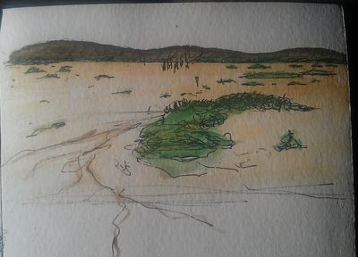 Inland areas of the islands form seasonal tidal flats with the huge seasonal variation in tides- in this way the effects of Climate change and Sea level rise are already visible.
 -
 Traditional seafaring and sea harvesting lifestyles continue and the perceptions of 'sea and the land' are not as divided as in other cultures.
 -
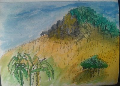 The landscape is in the Dry tropics and characterised by rocky volcanic islands, and dry tropic vegetation. Rainforests are found only in small valleys.
 -
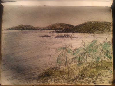 The Landscape and Seascape are one- with islands often visible on near or far horizons.


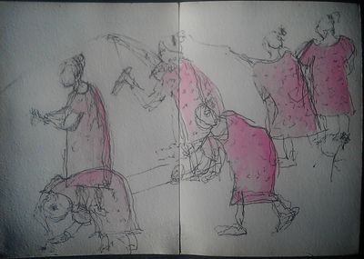
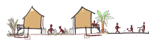
The photos below show photographs of characteristic sea side social spaces made from improvised materials by the islanders.


Case study site: Iama Island
Our case study focuses specifically on Iama Island (Yam Island), located in the central group of Islands in the Torres Strait. It is a vegetated granite island with coral sand flats fringe, approximately 2.2km long by 1.5km wide, of a total area of 175 hectares.
Iama Island is characterised by three distinct landforms. The dominant landform is vegetated, steep hilly country. Another is the plateau ares on top of steep slopes which is inaccessible. The remaining is flat coastlines which are covered at some parts by dense mangroves.
-
![Reconstructed map (by Janice Thien) based on information at Iama Sustainable Land Use [1]](/images/thumb/e/e5/Iama_map.jpg/500px-Iama_map.jpg) Reconstructed map (by Janice Thien) based on information at Iama Sustainable Land Use [1]
Reconstructed map (by Janice Thien) based on information at Iama Sustainable Land Use [1]
![Reconstructed map (by Janice Thien) based on information at Iama Sustainable Land Use [1]](/index.php?title=File:Iama_map.jpg)
The community resides at the northwestern end of the Island, of flatland with an area of 300mx300m. The flat terrain rises to 1.5 meter above sea level, and is susceptible to sea level rise. The village is located between the air strip and the barge ramp towards the northwestern coastline. The residential area consists of dwellings, primary school, churches, council offices and workshop, and store.
The above information on Iama Island is extracted from Iama Sustainable Land Use [5]
The population maintains steadily around 340 residents (174 in 1998) for the past 10 years, with a density of 198.7 persons per kilometre square. The 2006 census shows that the average age of the population is 20 years, 40.1% of the population were under 15 years old.
Survey done by Australian Bureau of Statistics had a result showing that of the 133 people in employment in 2006, 111 people (83%) were in Public Administration and Safety Sector. This trend is seen across the overall Torres Strait Region, from the survey done in 2006, at least 70% of employment is in the Public Administration and Safety Sector, the remaining employment proportion are mainly distributed among retail, education and training, healthcare and social assistance.
Torres Strait is a busy shipping lane, members of the communities work regularly as pilots for shipping vessels having expert knowledge of the area. This, in addition to local government employment could explain the high number of employees in Public Admin. Not one member of the island is employed in construction, and further, only three in education- presumably childcare. This would significantly impact on the skills basis for local adaptive measures to be skilfully delivered by the islands residents- at least in a supervisory role.
Cultural/social/political context
- Brief explanation of culture, political economy, legal framework
The Torres Strait is politically part of Australia and is the birthplace of native title law. Torres Strait Islanders are a separate people in origin, history and way of life than the mainland Australia aboriginal people. They now live in 18 communities on 17 islands. The Islanders were fishermen, hunters and agriculturalists and are fearless defenders of their territories and cultures. Each community is distinct, having their own traditions, laws and customs.
This image [6] shows Torres Strait Islander performing their traditional dance.
Torres Strait islanders have had some contact with outside influences and traders for centuries, including Chinese, Dutch and Portuguese explorers and traders in addition to Pacific Islander traders and explorers. From settlement in the late 19th century by colonising European cultures, traditional Torres Strait Islander society was changed by the discovery of commercial quantities of pearlshell, arrival of Christian missionaries, and all islands being legally annexed to the Colony of Queensland by 1879. In the 1980s and 1990s, Eddie Mabo- A Torres Strait Islander, challenged the Australian Government in the high court of Australia over the Australian constitutional recognition of indigenous occupation of lands prior to European settlement. He succeeded in his challenge and the Australian constitution was changed to recognise Indigenous occupation. Torres Strait Islanders were the first Indigenous Australians to be granted local self-governence. Their efforts have influenced Australian laws regarding Indigenous land tenure, and they are still working on protecting their land and sea rights.
The TSRA (Torres Strait Regional Authority) is established on 1 July 1994 in response to local demands for greater autonomy, to manage their affairs based on their own island customs. The region has its own flag signifying unity and identity of the different groups of islanders. The government agencies are based on Thursday Island, the administrative centre for Torres Strait region. The organisational chart can be viewed at [7]
The existence, condition and management of the natural environment is fundamental to the livelihood of the Iama Island community, and Torres Strait Islanders in general. The natural environment includes animals, coastline, tides and storm surges, waterways and wetlands, land and soil, and bushfire. These must be part of all decisions and plans. The well being of the natural environment is crucial for community health and its close association with cultural significant activities.
Local Climate
- What are the climatic conditions at present? Have there been extreme weather events in the near past?
- Which changes are expected? Is there any evidence?
Torres Strait Islands have tropical maritime climate, with minimal rainfall during winter months between June to October. Graphs below are sourced from Torres Strait Climate Change Strategy 2010-2013 [8]
-
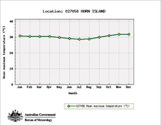 Temperature
 -
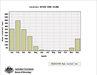 Rainfall
 -
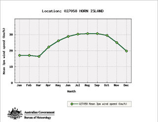 Winspeed


The Torres Strait Islands region is subject to cyclonic systems which bring destructive winds and high seas, posing threats to low-lying islands including Iama Island. Due to the close proximity to the equator, the cyclonic forces are weaker than further away however they still create significant impacts on the island. The Islanders’ cultures, societies and economies rely heavily on the ecosystem. In 2005 and 2006, a number of the islands were subject to king tides and had lives threatened and damage caused. Major expected impacts of climate change will be from warmer temperature stress, rising seas, increased frequency of extreme weather events, and oceanic acidification. Visible changes due to climate change are increased erosion, strong winds, land accretion, increasing storm frequency and rougher seas that elders have never encountered before. These events, considered emerging evidence of early climate change have caused impacts on the number of turtles nesting and altered birds’migration patterns. Dugongs (sea cow) that are traditionally hunted for meat have become more scarce. Gardeners are less certain when to plant their crops due to seasons shifting. Climatic conditions feature strongly in Torres Strait Island spiritual belief systems- including names and qualities of seasonal winds, and significance of ocean currents and climatic events such as Water Spouts. The current shifting nature of climate may therefore have some significant cultural/ spiritual impacts. Their ways of life are threatened both physically by climate change effects on the local environment, and culturally by ongoing issues of westernisation and policy and governance. How the Torres Strait islanders adapt to these changes will determine the long term survival and integrity of their culture.
Image [9] showing King tide invasion of Iama Island.
Illustration: Table or time line
Analysis of vulnerability
If you consider these potential changes - which aspects/functions of your case study would be affected?
Climate Change Direct Impact:
- Inundation and destruction towards public facilities, Housing, settlement and sewage systems
- Inundation and salination of fertile soils that provide for food production
- Degradation of significant cultural sites such as burial and sacred grounds, hunting and gathering places.
- Change in coral growth/coral bleaching fish and crustacean habitats, diminished sea food resources
Climate change indirect impact from the complex interactions between physical, ecological and social systems.
- Freshwater availability
- Flooding of above ground rubbish tips and and existence of standing water increase the spread of diseases
- Increase in living expenses due to increase in fuel and travel cost.
- Changes in traditional hunting and cultural practices
- Emergence of refugees between borders, putting on population pressure
- Some islands may disappear completely or lose large area of land, forcing relocation and dispossession
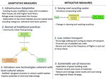
Proposals for Climate Change Adaption
- How could your case study area become more resilient to climate change? - Which measures would need to be taken to adapt to the new situation? - How could you assure sustainability of these measures? - Please describe 2-3 measures
1. Infrastructure adaptation:
- New collective housing community that is set with floor levels higher than prediced levels of inundation. Where inundation is unavoidable, housing is either removed or usage and design modified to cope with inundation.
- Restoration of sea shore habitats around coastal areas including mangrove, saltmarsh and dune systems for mitigation of sea rise impacts is given priority. Seawalls and bunds may be repaired or improved where they are effective, however these infrastructures tend to shift erosion to other areas, and worse, create a false sense of security for constructions behind the sea wall thus increasing vulnerability. Offshore protection could include establishment of artificial reefs for the establishment of enhanced local fisheries. In addition, reefs modify the velocity of storm surges and the force induced destructive potential. Structures are modified to cope more efficiently with water inundation where this may occur.
- Examine alternative means of power and energy creation based on wind energy, tidal or wave energy, solar or solar thermal. Investigate existing examples of these technologies: particularly tidal energy given the extremes of tides in the Torres Strait and the traditional cultural paradigms of harnessing the seas 'power'. This strategy will both reduce the economic burden of escalating energy costs, and simultaneously reduce carbon emissions
- Introducing Reef Ball, a marine breakthrough:
Reefballs are designed to create sealife habitat, prevent erosive forces of waves and protect onshore assets from coastal erosion. They worked very well when used in a high number of modules. They would be well suited to Iama island for assisting in the protection of island resources. These designed artificial reef modules are able to last against sea forces and do not erode/breakdown easily. The biggest expense is getting the reefs into the sea. It Is worth investigating the possibility of engineering reefballs on Iama Island to reduce the cost of transport. This would involve the transport of raw materials- concrete and moulds, however this could be cheaper in the long term than purchasing them off shore. This could become a marine reserve at a bigger scale, and possibly a sustainable tourism industry.
Image of reefball can be viewed here [10]
Fore more information, please view Reef Ball Foundation website [11].
2. Explore alternative livelihood options and income sources
- Gain resources for resilience measures and to be as self sufficient as possible in terms of food sources.
- Revival of traditional management practice of natural resources should be encouraged to ensure food affordability and security.
Two types of productive landscapes can be established. First is communal food garden in easy reach of the houses for community food growing, to experiment with new ideas and for education opportunities. Second type is bush garden, cultivate/produce staple food at bigger scale further from home and can be done on steeper land. The gardens are to be built with natural resources and bush materials including native bamboo, and use of natural fertilisers from fish waste and chicken manure. This project can enhance sense of community living, encourage exchange of food, seeds, and materials. In addition it could have a huge impact on the pressing need of reducing waste through reducing the reliance on packaged foods, and recycling generated food wastes.
- Chicken pens within the village and forest style: chicken forage runs can be built to have meat and eggs in production within the natural environment within close proximity to the village.
-
 Section showing community utilising spaces between dwellings for food growing.(by Janice Thien)

- Aspects to consider about food growing
- Soil type and quality
- Availability of seeds, planting materials and knowledge
- Land ownership and landuse tradition.
-Predation on poultry from Cats/ Dogs
Precedent: SUSTAINABLE AGRICULTURE - Prefabricated Modular Sustainable Housing - (Marigot, St. Martin)
View at [12]
Start by introducing Continuous Productive Urban Landscape (CPUL), a strategy interlinking pockets of spaces for food growing, redefining the usage of leftover and underused urban spaces.The urban food benefits more than personal well being and community enjoyment. Its social, economic, environmental and spatial relevance form complex and integrative relationships for urban sustainability.
-
![Reconstructed diagram (by Janice Thien) based on urban food system by Bohn&Viljoen Architects (2002) found at The Edible City: Envisioning the Continuous Productive Urban Landscape (CPUL)[[2]](/images/thumb/1/16/Foodmap.jpg/600px-Foodmap.jpg) Reconstructed diagram (by Janice Thien) based on urban food system by Bohn&Viljoen Architects (2002) found at The Edible City: Envisioning the Continuous Productive Urban Landscape (CPUL)[[2]
Reconstructed diagram (by Janice Thien) based on urban food system by Bohn&Viljoen Architects (2002) found at The Edible City: Envisioning the Continuous Productive Urban Landscape (CPUL)[[2]
![Reconstructed diagram (by Janice Thien) based on urban food system by Bohn&Viljoen Architects (2002) found at The Edible City: Envisioning the Continuous Productive Urban Landscape (CPUL)[[2]](/index.php?title=File:Foodmap.jpg)
3. Risk assessment and disaster management plans need to be incorporated and consistently reviewed and improved. Involve the community of Iama as much as possible in this process. Lower lying island communities such as Iama need planning for worst case scenario of sea level rise and how to manage the aftermath. Disaster management plans for the present to immediate future- specifically for storm surges are key in developing a strategy towards long term climate change adaption for sea level rise. Capacity building of community to prepare for storm surges as a potential disaster are like a 'dress rehearsal' for more permanent sea level rise. It is clear that infrastructure development required for disaster mitigation now, and addressing underlying issues of social and cultural vulnerability could be of great benefit for adaption to sea level rise later. These processes may include Items 1 and 2 above and in addition, scoping potential settlement and urban planning locations for the village. This process has been proposed by independent consultants, however concept planning and proposals for shifts in this direction have not yet been made.
Proposals for Climate Change Mitigation
-Which measures would need to be taken to reduce greenhouse gas emissions and other drivers of climate change within your case study area? How could you assure sustainability of these measures? Please describe 2-3 measures
1.Sustainable use of Water and Food resources
- Promote harvesting water locally and water recycling, and low carbon/ energy intensive water desalination technologies, Solar water heating technologies waste reduction, and community garden initiatives to reduce carbon footprints and food miles. Use of bulk foods shopping only for island shop with no/ Paper only packaging on products. Introduction of appropriate water use practices and technologies, change in washing and cleaning practices. Waste water and storm water is collected and treated, cleaned, processed, and recycled for irrigation. The solid parts of the waste water can be processed into compost and fertilisers for bamboo groves for construction materials.
- Precedent: Composting Toilet at Fiji Island
by AES (Architectural Environmental Strategies) based in Stockholm, Sweden. Please view [13]
- Water desalination powered by offshore wind turbine example as shown here [14]
These technologies could be modified to be cultural and social symbol of the islands sustainability.
2. Increase transport efficiency, encourage sustainable way of transport, walking, cycling- Given the islands size, cars are not really a necessary element on the island- investigate smaller powered vehicles for any motorised transport. This would reduce the load on island paths and road infrastructure. Encourage the use of paddled sea craft as per tradition as an alternative to small powered watercraft. The Airport Strip Is currently a large proportion of habitable area of the island. Investigations of the main users of the airport and air service may be helpful to determine the long term viability of this service. Currently there are three flights per day from the island which seems excessive for an Island of this population. Could this number of flights be reduced and condensed into 3-5 flights per week?
3. Application of an island green building code that specifies passive solar design, shade, and utilises insulation and ventilation as atmospheric cooling devices. Recommends the reclaim and reuse materials as much as possible, In addition to using locally available waste building materials to create resilient structures. This could include utilising shipping containers as a building material (see http://www.cargotecture.com for examples of these options.) Explore possibilities of working at a bigger scale into Regional Waste Strategy that addresses building materials. A building code could have the potential of reducing dependancy on fossil fuels used for air conditioning, lighting and water heating/ pumping.
4. Reducing dependancies on fossil fuels will reduce the carbon footprint and other greenhouse gasses of the islanders and therefore mitigate the promotion of the greenhouse effect, pushing up global temperatures. Given the small size and population of the island, electricity production from diesel generators (their current electricity source) is particularly carbon intensive per capita. This may be off set by minimal car use and small engine/ boat use however changes to electricity generation would be an achievable and high impact change for the purposes of mitigation. To this end, there is a need to examine alternative means of power and energy creation based on wind energy, tidal or wave energy, solar or solar thermal. Investigate existing examples of these technologies: particularly tidal energy given the extremes of Tides in the Torres Strait and the traditional cultural paradigms of harnessing the seas 'power' .
Your scenario
-How will this area look like in 2060? Please forecast one potential future development taking climate change into account
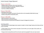
The main concern on Iama Island from climate change will be sea level rise. The predicted levels are hard to clarify with variable research, however we will be working with a level of 0.5 metre, with more frequent storm surges (also induced by climate change) causing inundation of a significant proportion of what was once dry land. We have proposed a staged approach.
2013- 2020 (7 years)
- Begin retreat, modification of structures for camping usage and revegetation of sand spit on the shoreline.
- Mangrove habitat saltmarsh and dune restoration.
- Integrate habitat restoration with 'seawall' restoration- This means NOT using traditional seawalls but rather modifying the topography to the height of seawalls and including habitat as a protective boundary to buffer sea velocity.
- Prioritise community education around construction techniques for the community to use for adaptation
- Education around waste reduction and modification of patterns of consumption for minimising waste
- Assess where water incurs into the community areas and buffer in a similar way
- Commence food gardens program.
- Review Disaster management planning to incorporate adaptive measures for climate change and associated sea level rise
- Assess housing within the village to be retrofitted and housing to be raised/removed and replaced accounting for the needs of increased density and population.
- Commence planning new communal village area at Gaurab create options study for village
- Commence reefball prototyping and test in situ as artificial reefs for sea calming devices.
- Commence construction of sea drainage street features- swale channels and vegetated drains.
- Water tanks/ solar power/ flood proof composting toilets installed
2020-2040 (20 years)
-Continue with above projects- reefballs,food gardens, drainage, mangrove and dune maintenance and establishment
- Retrofitting raising, and replacing susceptible housing continues within existing village
- Commence and complete construction of Gaurab section with relocatable prefabricated housing
- Construction of new energy infrastructure that has relocatable facility.
- Construction of energy efficient desalination plant.
- Community leads construction efforts for reefs and sea shore infrastructure.
2040-2060 (20 years)
- Expertise is exported to other islands
- Continued efforts with above projects and through community based resources and education, works are able to be be planned and led by community members.
- Community members are able to facilitate disaster management planning and incorporate these into long term climate change and sea level rise plans.
What can be generalized from this case study?
-Are there any important theoretical insights?
- Social and economic disadvantages such as lack of infrastructure, health services and employment opportunities reduce capacity of the community to adapt to climate change, making their lives and culture more vulnerable.
- Climate change can be a direct threat to the rights of communities, such as the rights of food, health, culture, and healthy environment.
-Which research questions does it generate?
- There has been immense effort carried out for research and planning, but how much of these strategies are being taken into action? what are the obstacles? Funding resources, human rights and sociopolitical reasons seem to be the issue.
-Short statement plus background notes
- The complexity of the political features, cultures, and ecosystem of Torres Strait Region generates many uncertainties towards climate change issues. Dealing with uncertainties becomes a key management approach. Robust solutions for potential uncertainties, continuous monitoring and review are essential. Actions have to taken in consideration of the local distinctiveness of each islands. The level of inundation in future and how tolerable it will be for the communities are unknown, the last resort is relocation of the communities which is a great challenge both economically and culturally.
Presentation Slides
-
 Slide One
 -
 Slide Two
 -
 Slide Three


![[4]](http://www.google.com.my/imgres?um=1&hl=en&sa=N&tbo=d&biw=1366&bih=705&tbm=isch&tbnid=kc3AkrENIO7BvM:&imgrefurl=http://torresstraitclimate.org/the-region-and-its-people/&docid=w119U2tk9TAhWM&imgurl=http://torresstraitclimatedotorg.files.wordpress.com/2011/05/annika_torres-strait-map11.png&w=3054&h=1934&ei=TcnzUIbCGMixkgWWlYGIBw&zoom=1&iact=rc&dur=4&sig=115660871284287683847&page=1&tbnh=141&tbnw=222&start=0&ndsp=26&ved=1t:429,r:18,s:0,i:135&tx=90&ty=59)
![[6]](http://www.google.com.my/imgres?um=1&hl=en&sa=N&tbo=d&biw=1366&bih=705&tbm=isch&tbnid=6ySmdM04RK7FxM:&imgrefurl=http://www.couriermail.com.au/ipad/performers-mark-coming-of-the-light/story-fn6ck51p-1226085146869&docid=eD6MfH44EbiawM&imgurl=http://resources2.news.com.au/images/2011/06/30/1226085/146662-torres-strait-islanders-performing.jpg&w=650&h=366&ei=18nzUM64IIfQlAWgioCAAw&zoom=1&iact=hc&vpx=668&vpy=374&dur=1967&hovh=168&hovw=299&tx=145&ty=108&sig=115660871284287683847&page=3&tbnh=144&tbnw=274&start=58&ndsp=33&ved=1t:429,r:88,s:0,i:351)
![[9]](http://www.google.com.my/imgres?um=1&hl=en&tbo=d&biw=1366&bih=705&tbm=isch&tbnid=eqxvN3JHC1lthM:&imgrefurl=http://humanrights.gov.au/social_justice/nt_report/ntreport08/Climate_Change_Community_Guide.html&docid=I2CDj58vOfgHOM&imgurl=http://humanrights.gov.au/social_justice/nt_report/ntreport08/images/cg_pic3.jpg&w=480&h=357&ei=xPrzUJWcGc7PkAW81YHoBQ&zoom=1&iact=hc&vpx=4&vpy=126&dur=4829&hovh=194&hovw=260&tx=139&ty=75&sig=115660871284287683847&page=1&tbnh=137&tbnw=185&start=0&ndsp=26&ved=1t:429,r:0,s:0,i:78)
![[10]](http://www.google.com.my/imgres?um=1&hl=en&sa=N&tbo=d&biw=1366&bih=705&tbm=isch&tbnid=m9UTuFPF_nMk2M:&imgrefurl=http://www.reefball.org/brochure.htm&docid=FsT0n2ar5yli2M&imgurl=http://www.reefball.org/newfrontpage/smallsizes.jpg&w=480&h=372&ei=qNTzUIaNIMO1kgWvroGYBQ&zoom=1&iact=hc&vpx=4&vpy=381&dur=583&hovh=198&hovw=255&tx=140&ty=124&sig=115660871284287683847&page=1&tbnh=141&tbnw=190&start=0&ndsp=28&ved=1t:429,r:21,s:0,i:150)
Image Gallery
-
your image text
-
your image text
-
your image text
-
your image text
-
your image text
-
your image text
-
your image text
-
your image text
References
Please add literature, documentations and weblinks
1. TSRA (2010). Torres Strait Climate Change Strategy 2010–2013. Report prepared by the Environmental Management Program, Torres Strait Regional Authority, May 2010 [15]
2. Torres Strait Island Regional Council Local Disaster Management Plan [16]
3. Iama Sustainable Land Use Plan Part 2 [17]
4. Observed and Future Climates of the Torres Strait Region [18]
5. Iama Community Booklet 2012 by Torres Strait and Northern Peninsula Area Regional Plan 2009-2029 [19]
6. Torres Strait Islanders by Anna Shnukal, From: Brandle, Maximilian (ed.) Multilcutlural Queensland 2001: 100 years, 100 communities, A century of contributions, Brisbane, The State of Queensland (Department of Premier and Cabinet), 2001.[20]
7. Torres Strait Island and Northern Peninsula Area Regional Plan 2009-2029 [21]
8. Household Gardening Skills by Solomon Islands Kastom Gaden Association: Training tools for Pacific Island Communities [22]
9. Community Vulnerability and Adaptation to Climate Change Assessment Report [23]
10. Managing Mangroves for Resilience to Climate Change, by IUCN [24]
11. Water Management on Islands – Common Issues and Possible Actions [25]
12. The Edible City: Envisioning the Continuous Productive Urban Landscape (CPUL)[26]
13. Climate Change and Human Rights of Torres Strait Islanders [27]
About categories: You can add more categories with this tag: "", add your categories