Maaspuntweg: Difference between revisions
No edit summary |
No edit summary |
||
| (29 intermediate revisions by 2 users not shown) | |||
| Line 44: | Line 44: | ||
<gallery caption=" " widths="150px" heights="150px" perrow="5"> | <gallery caption=" " widths="150px" heights="150px" perrow="5"> | ||
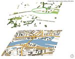
Image:Area_clock.jpg|Bird view of the area showing the use during the day. | Image:Area_clock.jpg|Bird view of the area showing the use during the day. | ||
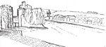
Image:121111_sketch1_Built.jpg|Built environment of the area | Image:121111_sketch1_Built.jpg|Built environment of the area. Sketched from opposite river bank. | ||
Image:121111_sketch1_Trees.jpg|Vegetation present in the area, | Image:121111_sketch1_Trees.jpg|Vegetation present in the area. Sketched from opposite river bank. | ||
Image: | Image:121111_sketch1_Elements.jpg|View of the natural elements, sky and water. Sketched from opposite river bank. | ||
Image: | Image:121111_sketch1_all.jpg|All elements put together for a total impression of the area. | ||
</gallery> | Image:121111_sketch1_lights.jpg|Sketch showing the poor lighting of the area during night time. | ||
Image:121111_sketch2_sculpture.jpg|Sketch in perspective of the sculpture and path, looking towards the bridge. | |||
Image:121111_sketch2-viewnorth.jpg|Sketch of part of the area looking northwards. | |||
Image:121111_sketch2-view.jpg|Sketch of part of the area looking southwards. | |||
</gallery> | |||
== Exercise 2: Landscape Layers == | == Exercise 2: Landscape Layers == | ||
| Line 54: | Line 58: | ||
'''Time frame: November 15 - 29, 2011''' | '''Time frame: November 15 - 29, 2011''' | ||
* | ''Time frame: November 15 - 29, 2011''' | ||
*time based changes and 'landscape biography', and/or: | |||
*topography, open spaces, built, green, traffic and water structures on different layers. *Definition of zones with coherent character | |||
*Description of this character. | *Description of this character. | ||
<gallery caption=" " widths="150px" heights="150px" perrow="5"> | |||
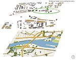
Image:111206_Layers_Icons.jpg|Map of Maastricht, main roads and features. | |||
Image:111206_Layers_City_Water.jpg|Water layer in urban context. | |||
Image:111206_Layers_City_Roads.jpg|Layer representing the main roads in Maastricht. | |||
Image:111206_Layers_City_Vegetation.jpg|Vegetation layer within the urban area. | |||
Image:111206_Layers_City_Built.jpg|Layer representing the built environment within the city. | |||
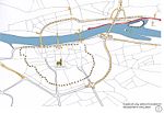
Image:111206_Layers_Area_Water.jpg|Water Layer within the study case area. The green Oval shows the study case area. The dotted line is the pedestrian path crossing through. | |||
Image:111206_Layers_Area_Roads.jpg |Layer representing access roads around the area. | |||
Image:111206_Layers_Area_Vegetation.jpg|Vegetation layer surrounding the study case area. | |||
Image:111206_Layers_Area_Buildings.jpg|Built layer environment within the study case area. | |||
</gallery> | |||
| Line 67: | Line 85: | ||
* Preparation of short presentation | * Preparation of short presentation | ||
'' | <gallery caption=" " widths="150px" heights="150px" perrow="5"> | ||
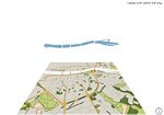
Image:111213_Pictograms_Maps-1.jpg|This first set of two maps, shows the transport methods used in the area. People move by bike, boat, car. Even though the area is mainly used as gateway to the city centre, it also includes some import an business centers, such as the Governmental buildings and a large private company. | |||
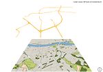
Image:111213_Pictograms_Maps-2.jpg|The second set of maps, shows how people move around the area according to different purposes. Many joggers run along the path, as per dog walkers or people having a stroll. There are also areas where to rest and look at the view, mainly used by families with children. | |||
Image:111213_Pictograms_Maps-3.jpg|This large open field is a remain of the old countryside. Part of the field is occasionally occupied with cattle. Most of the area is used by joggers or bikers. During summer time people can enjoy the river Maas. The area is not very accessible as the paths are not cleared out and very often muddy. | |||
</gallery> | |||
''Youtube video link http://www.youtube.com/watch?v=IQJCXSlmDPI&feature=g-upl'' | |||
== Exercise 4: Communication Concepts == | == Exercise 4: Communication Concepts == | ||
| Line 75: | Line 103: | ||
* Which measures would be necessary for enhancing the awareness for the area? | * Which measures would be necessary for enhancing the awareness for the area? | ||
* Students are free to choose their method. | * Students are free to choose their method. | ||
<gallery caption=" " widths="150px" heights="150px" perrow="5"> | |||
Image:120109_communication_installation.jpg|Step 1 - Do you want to break from a conventional path? | |||
Image:120109_communication_installation2.jpg|Step 2 - What better than balloons to attract people's attention? | |||
Image:120109_communication_installation3.jpg|Step 3 - Let's take a stroll on the water! | |||
Image:120109_communication_installation4.jpg|Step 4 - Enjoy the view and the water layer! | |||
</gallery> | |||
''Please publish your findings here'' | ''Please publish your findings here'' | ||
Latest revision as of 10:53, 10 January 2012
---> back to overview of Case Study List
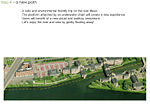
The intricate area along the river Maas
| Name | Maaspuntweg crossing Gouvernementspad | |
| Location | Maastricht | |
| Country | Netherlands | |
| Authors | Alessandro Vino | |

| ||
| <googlemap version="0.9" lat="50.839924" lon="5.701228" type="satellite" zoom="16" width="300" height="250">
</googlemap> | ||
Short Introduction to the Area of Study
The study area covers the pedestrian and bike path running underneath the J.F Kennedy bridge, stretching along the east bank of the Maas river ending at a government building in Maaspuntweg 38.
The overall area is rather intricate, it includes private and public buildings with diverse functions, I shall focus on the pedestrian and bike path running throughout the area. There are some interesting features that could increase the public use of the site, however with the current settings those are not put into real values. One of the major factors is the presence of a government building, which take a large portion of the surface imposing certain restrictions over it, such as lack of directions, lights and proper distinction between sidewalk and bike path.
The study area covers approximately 7'600 square metres.
Exercise 1: Sketching the Landscape
Time frame: October 25 - November 15, 2011
Student activities:
- Creation of analytical drawings and sketches
- Presentation of results
Please upload a selection of your drawings/sketches/mental maps and add them to the image gallery
Sketches and Drawings
-
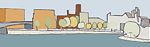
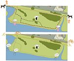
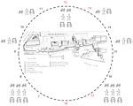 Bird view of the area showing the use during the day.
 -
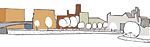 Built environment of the area. Sketched from opposite river bank.
 -
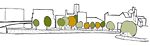 Vegetation present in the area. Sketched from opposite river bank.
 -
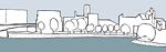 View of the natural elements, sky and water. Sketched from opposite river bank.
 -
 All elements put together for a total impression of the area.
 -
 Sketch showing the poor lighting of the area during night time.
 -
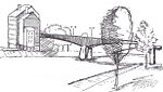
 Sketch in perspective of the sculpture and path, looking towards the bridge.
 -
 Sketch of part of the area looking northwards.
 -
 Sketch of part of the area looking southwards.


Exercise 2: Landscape Layers
Time frame: November 15 - 29, 2011
Time frame: November 15 - 29, 2011'
- time based changes and 'landscape biography', and/or:
- topography, open spaces, built, green, traffic and water structures on different layers. *Definition of zones with coherent character
- Description of this character.
-
 Map of Maastricht, main roads and features.
 -
 Water layer in urban context.
 -
 Layer representing the main roads in Maastricht.
 -
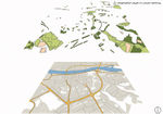 Vegetation layer within the urban area.
 -
 Layer representing the built environment within the city.
 -
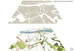
 Water Layer within the study case area. The green Oval shows the study case area. The dotted line is the pedestrian path crossing through.
 -
 Layer representing access roads around the area.
 -
 Vegetation layer surrounding the study case area.
 -
 Built layer environment within the study case area.


Please publish your findings here
Exercise 3: Behaviour Patterns
Time frame: December 6 - 20, 2011
- How do people behave in this area? How do they use the space? What is important for them?
- Observation of study area, interviews with local people and mapping of use patterns.
- Preparation of short presentation
-
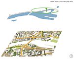
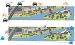 This first set of two maps, shows the transport methods used in the area. People move by bike, boat, car. Even though the area is mainly used as gateway to the city centre, it also includes some import an business centers, such as the Governmental buildings and a large private company.
 -
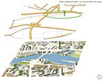
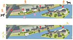 The second set of maps, shows how people move around the area according to different purposes. Many joggers run along the path, as per dog walkers or people having a stroll. There are also areas where to rest and look at the view, mainly used by families with children.
 -
 This large open field is a remain of the old countryside. Part of the field is occasionally occupied with cattle. Most of the area is used by joggers or bikers. During summer time people can enjoy the river Maas. The area is not very accessible as the paths are not cleared out and very often muddy.


Youtube video link http://www.youtube.com/watch?v=IQJCXSlmDPI&feature=g-upl
Exercise 4: Communication Concepts
Time frame: December 19, 2011 - January 17, 2012
- Based on the different landscape assessment approaches students will develop a communication concept for their area of study
- Which measures would be necessary for enhancing the awareness for the area?
- Students are free to choose their method.
-
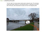 Step 1 - Do you want to break from a conventional path?
 -
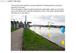 Step 2 - What better than balloons to attract people's attention?
 -
 Step 3 - Let's take a stroll on the water!
 -
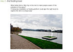
 Step 4 - Enjoy the view and the water layer!


Please publish your findings here
Image Gallery
-
your image text
-
your image text
-
your image text
-
your image text
-
your image text
References
* Please make sure that you give proper references of all external resources used.
* Do not use images of which you do not hold the copyright.
* Please add internet links to other resources if necessary.
About categories: You can add more categories with this tag: "", add your categories