Collaborative Design Planting Design Working Group 8: Difference between revisions
Andreea Webb (talk | contribs) |
Andreea Webb (talk | contribs) |
||
| Line 89: | Line 89: | ||
<gallery caption="Image Gallery" widths="150px" heights="150px" perrow="5"> | <gallery caption="Image Gallery" widths="150px" heights="150px" perrow="5"> | ||
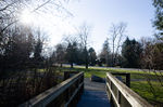
Image:Manuel_Park_(1_of_1)-4.JPG| | Image:Manuel_Park_(1_of_1)-4.JPG| View from the central bridge towards the open space, featuring an ornamental stone. | ||
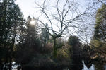
Image:Manuel Park - The Island.JPG| Looking toward the island you can notice there is only the path and no other access to the excessive vegetation. | Image:Manuel Park - The Island.JPG| Looking toward the island you can notice there is only the path and no other access to the excessive vegetation. | ||
Image:Manuel Park view of the peninsula.JPG| A view of the tip of the peninsula. | Image:Manuel Park view of the peninsula.JPG| A view of the tip of the peninsula. | ||
Revision as of 09:42, 28 January 2014
---> back to group page working group 8
Please add the title of your case study here, adjust the map coordinates and replace the moa image with a characteristic image of your site
| Name | Manuel Park | |
| Location | Chilliwack | |
| Country | Canada | |
| Authors | Andreea Webb, Moeen Omrani, Candela Bañon | |

| ||
|
| ||
Landscape and/or urban context of your case
- Biogeography, cultural features, overall character, history and dynamics
- The green space we decided to use for our design project is located on the South part of Chilliwack in Canada, British Columbia at the intersection of the Vedder Rd. with Manuel Rd. therefore it's called Manuel Park.
- Chilliwack is a small city in the Fraser Valley, situated 100 km away from Vancouver with a population of about 80,000. Surrounded by high mountain peaks and rivers, it was once a small agricultural town, the mild climate providing good conditions for growing crops.
- Most public green spaces have a very natural feel and appearance, minimal human intervention and amenities.
- Manuel Park is a fairly new park, resulted after the rezoning of a private propriety and the development of a new residential village. The circumstances that lead to the decision of maintaining the green space and making it public are unclear, it might have been the difficulty and higher costs of development and maintenance due to the land forms or it may have been designated or requested by the city to serve as green space for the newly established community.
- Manuel Park serves as a crossing point for residents of the Sardis area, being at the roads intersection, across the street from a Primary School and close to a small commercial area, it is high circulated but it doesn't seem to serve much as a resting or play area.
- The place seems to have kept it's natural appearance and wildlife habitat.
- The park features three small pedestrian bridges to allow easy access from the residential area and diagonal crossing over the creek. Some improvements have been brought to the park at the end of the summer of 2013, such as gravel trails, a bench, a picnic table and some of the invasive vegetation has been removed.
- The park's inhabitants are a wide variety of small birds, geese, ducks and racoons.
- Illustration: Map; sketches; short descriptive analyses
What are the objectives of your design?
Please give a short written argumentation (not more than 150 words). It is ok if you have different or even contradicting objectives within your group. Just make it explicit at the beginning of your process
Analytical drawings
Please add four analytical sketches/drawings (or montages/schemes) of your case. Every group member needs to contribute at least one drawing.
- Analytical Drawings
analytical drawing 1
- Yourfilename2.jpg
analytical drawing 2
- Yourfilename3.jpg
analytical drawing 3
- Yourfilename4.jpg
analytical drawing 4

Projective drawings
Please add four projective sketches/drawings (or montages/schemes), of course with an emphasis on planting design/vegetation aspects. Every group member needs to contribute at least one drawing representing his/her individual ideas.
- Projective Drawings
- Yourfilename1.jpg
projective drawing 1
- Yourfilename2.jpg
projective drawing 2
- Yourfilename3.jpg
projective drawing 3
- Yourfilename4.jpg
projective drawing 4
Design Synthesis
Please analyse the individual approaches presented so far and evaluate their strengths and weaknesses (you may use the SWOTanalysis model). Try to create a synthesis and represent it with a plan and some sketches. You can still use drawings/sketches.
- Design Synthesis Drawings
- Yourfilename1.jpg
synthesis drawing 1
- Yourfilename2.jpg
synthesis drawing 2
- Yourfilename3.jpg
synthesis drawing 3
- Yourfilename4.jpg
synthesis drawing 4
Summary of the collaborative process
Please reflect on your collaborative design process. Which potentials have you encountered? What was most difficult? What does collaborative design mean for you? (approx 150 words).
Image Gallery
You may add a series of images/photos in addition to the sketches/drawings
- Image Gallery
View from the central bridge towards the open space, featuring an ornamental stone.
Looking toward the island you can notice there is only the path and no other access to the excessive vegetation.
A view of the tip of the peninsula.
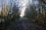
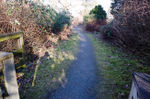
The path on the peninsula edged by shrubs on both sides.
-4.JPG)


References
* Please make sure that you give proper references of all external resources used.
* Do not use images of which you do not hold the copyright.
* Please add internet links to other resources if necessary.
About categories: You can add more categories with this tag: "", add your categories