Great War Island: Difference between revisions
Heike.kaiser (talk | contribs) |
Heike.kaiser (talk | contribs) |
||
| Line 87: | Line 87: | ||
# scientific teams (indirect- nature study,protection...) | # scientific teams (indirect- nature study,protection...) | ||
==== What is the role of the city? ==== | ==== What is the role of the city? ==== | ||
| Line 100: | Line 99: | ||
==== How do urban and natural structures interact? ==== | ==== How do urban and natural structures interact? ==== | ||
| Line 117: | Line 114: | ||
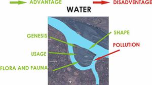
==== What is the role of water? ==== | ==== What is the role of water? ==== | ||
| Line 126: | Line 121: | ||
Water is the main creator of the island, it’s flora and fauna, attraction for recreation and garden colonies, humid micro climate.. | Water is the main creator of the island, it’s flora and fauna, attraction for recreation and garden colonies, humid micro climate.. | ||
Water brings lots of pollutants to the island banks, but it also cleans it, so this dynamic element is both creator and destroyer. | Water brings lots of pollutants to the island banks, but it also cleans it, so this dynamic element is both creator and destroyer. | ||
=== Analysis of program/function === | === Analysis of program/function === | ||
Revision as of 14:59, 16 December 2008
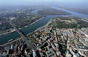
A natural river island located in the central city zone of Belgrade
Rationale: Why is this case study interesting?
- The project "Great War Island" is a proposition for protecting the Great and Small War Island on the river Danube,in Belgrade as the V category of IUCN categorization. Considering that this area is localized in the heart of the city center zone, it is a subject of interest for many different user groups. The final goal of this case study is to stop further degradation and preservation of native ecosystems of wetlands that are habitats for many rare and jeopardized species of ornithofauna.
- This area is very interesting from many different , scientific and owners approaches: urbanistic, artistic, esthetic, ecological, economical,political,touristic, biological....But most of all this case study shows how a legal protection is applied to conserve a very fragile natural ecosystem in the city tissue and how this case can be used as a recommendation for the similar cases in urban environment throughout planning .
Author's perspective
- What theoretical or professional perspective do you bring to the case study?
Landscape and/or urban context
Great War Island gained its militant name because throughout the history Great War Island was an important strategic point either for the conquest or the defense of Belgrade. Both, Turkish (1521.) and Austria-Hungarian (1915.) forces, used the island to launch their attacks against Belgrade. The island is located at the mouth of the Sava river into the Danube, in the Danube's widening, as a product of alluvial accumulation, which is caused by slowing down the river flow. Great War Island is generally triangularly shaped and covers an area of 2.11 km². It is low (the average altitude is 72m) , for the most part marshy and often flooded by the Danube. In recent years only the coastal areas of island were flooded. The process of sedimentation is not completed and the shape of the island is still changing. So there is possibility of making a land connection to the bank of the Danube, because the island is relatively close to the banks, at the closest it is just 200 meters. On the south, halfway between the Great War Island and the city of Belgrade is the remnant of previously larger Little War Island. One of Belgrade's beaches, Lido, is located on the northern tip of the island.
The main physical feature on the island is the canal of Veliki Galijaš. In time, the canal was cut off from the Danube and effectively turned into a lake, with an area of 0.24 km² and the major natural bird and fish spawning area on the island. During the droughty years the lake drains out completely causing damage to the closed eco-system centered around it. In 2007 the lake was connected to the Danube by the bioremediation.
There are three zones of protection on the island:
- Special areas – Zone of nature protection
- Developed areas – Zone of recreation
- General areas – Zone of turism
Currently Zone of nature protection is habitat for 196 bird species, many of which are endangered.
Plant life on the island includes the typical marshy flora. Dominant association is Salicetum albae. The typical vegetation is degraded by invasive introduced species (Amorpha fruticosa, Polygonum lapathifolium, Echinocytis lobata). There are some rare conifers on island (Taxodium distichum), which are also introduced.
Though officially uninhabited, almost a dozen of people live in small shacks in the island's interior, called urban garden colonies. They are mostly retirees who move to the island during the warm season and maintain their vegetable gardens, while in the winter they return to Belgrade. This is the one of main problems, because they are in Developed area and that is against the law. Whole situation is very complicated, because they came on the island many years before it was protected by government. Also, the major problem is bulky junk, which is deposed by the both rivers on the banks of the island. Process can not be controlled and it is a source of great pollution on the island.
Cultural/social/political context
- Brief explanation of culture, political economy, legal framework
Illustration: Bullet points, image, background notes
History
- How did the area/project/plan at the focus of the case study evolve?
Illustration: Table or time line
Spatial analysis of area/project/plan
- What are the main structural features?
- How has it been shaped? Were there any critical decisions?
Illustration: Map/diagram/sketches photos and background notes
Core Questions Working Group Nature Conservation / Water
What is the role of user groups?
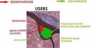
We can determinate user influence as the most important, because it changes the island in general. Considering the fact that all users aren`t equal in the way that they make use of the island benefits, their influence can be seen as direct and indirect.
- recreation (direct - junk, great pressure on protected zone, noise, light....)
- garden colonies ( direct - degradation, pollution, pressure on protected zone...)
- eco camp (indirect - education, promotion of health environment, cleaning the bulky junk on the Island....)
- public greenery service (direct - protection,conservation,improvement..)
- scientific teams (indirect- nature study,protection...)
What is the role of the city?
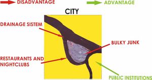
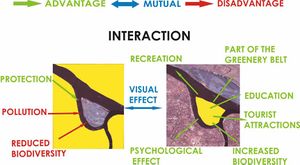
City is the frame of the island, so therefore it leaves a big mark on the island. Considering the fact that the island represents a great natural resource and that the city structure is everything but natural, the role of this gigantic concrete living machine is mostly in conjunction with pollution, noise, light, bulky junk, drainage.. But also we must take into consideration that city represent one great political and directional tool that has protected the island and is trying to conserve and improve this natural habitat to the best possible level.
How do urban and natural structures interact?
What is the role of water?
Water is the main creator of the island, it’s flora and fauna, attraction for recreation and garden colonies, humid micro climate.. Water brings lots of pollutants to the island banks, but it also cleans it, so this dynamic element is both creator and destroyer.
Analysis of program/function
- What are the main functional characteristics?
- How have they been expressed or incorporated?
Illustration: Map/diagram/sketches photos and background notes
Analysis of design/planning process
- How was the area/project/plan formulated and implemented?
- Were there any important consultations/collaborations?
Illustration: Map/diagram/sketches photos and background notes
Analysis of use/users
- How is the area/project/plan used and by whom?
- Is the use changing? Are there any issues?
Illustration: Map/diagram/sketches photos and background notes
Future development directions
- How is the area/project/plan evolving?
- Are there any future goals?
Illustration: Map/diagram/sketches photos and background notes
Peer reviews or critique
- Has the area/ project/plan been reviewed by academic or professional reviewers?
- What were their main evaluations?
Pleas add references, quotes...
Points of success and limitations
- What do you see as the main points of success and limitations of the area/project/plan?
Illustration: Summary table
What can be generalized from this case study?
- Are there any important theoretical insights?
Short statement plus background notes
Which research questions does it generate?
Short statement plus background notes
Image Gallery
- Yourimage.jpg
your image text
- Yourimage.jpg
your image text
- Yourimage.jpg
your image text
- Yourimage.jpg
your image text
- Yourimage.jpg
your image text
- Yourimage.jpg
your image text
- Yourimage.jpg
your image text
- Yourimage.jpg
your image text
- Yourimage.jpg
your image text
References
Please add literature, documentations and weblinks
About categories: You can add more categories by copying the tag and filling in your additional categories

