Green Infrastructure 2014 Group M - Case Study 4
---> back to group page working group M
BLUE NETWORK
| Name | Blue Network of Birmingham | |||||||||||
| Country | UNITED KINGDOM | |||||||||||
| City | Birmingham | |||||||||||
| Authors | Ilona Feklistova | |||||||||||

| ||||||||||||
| {{#widget:GoogleMaps | width=300 | height=240 | lat=52.486249 | lng=-1.8904009 | zoom=10 | centermarker=yes | maptypecontrol=yes | overviewmapcontrol=yes | largemapcontrol=yes | scalecontrol=yes
}} | ||
Rationale: Why is this case interesting?
Birmingham is a metropolitan district placed in West Midlands of England and is one of the most populous and densely built-up city in the Great Britain. Similarly to many other fast growing urban areas in the world Birmingham faces pressures from increase in population with its environmental and socioeconomic consequences. Along with that it goes through structural transformation where the service sector becomes the central for redevelopment of the city and regeneration of old industrial areas. Along with the number of abundant industrial buildings the wide spreading network of canals and railroad bear evidence of great industrial past when the city was called a "workshop of the World". These arteries were efficient transportation systems and catalytic for industrial past of the city. Today, partly abundant these widely spreading networks may have an essential value for improving green infrastructure especially due to their connection to rural areas. According to the report of local municipality Birmingham’s urban structure fails to fully respond to the demand of biodiversity, recreation and flood risk services, as well as mitigate effects of climate change. Thus I want to research if formal industrial infrastructure can increase the capacity of the city to create more resilient green network.
Author's perspective
I graduated with a Bachelor of Science Degree in Landscape Architecture and I had proceeded my studies in Estonian University of Life Sciences. At the moment I am working on my Master thesis that is explores Identity of Urban Allotments. Birmingham is an unfamiliar place for me. I have moved to UK because of the internship and I am staying in small town - Welshpool that is 86 km from the formal 'industrial heart' of UK - city of Birmingham. The amazing canal system that was developed in UK for transportation is absolutely a new element for me in a cultural landscape. Thus I am interested to explore it cultural-historical aspects and understand its potential for green infrastructure.
Landscape and/or urban context of your case
- Geology
Plateau The main Birmingham plateau can be subdivided into smaller units separated by rivers. North of the River Tame is the low Sutton Plateau. On its western edge a ridge runs from North to South where it rises up to the prominent landmark of Barr Beacon. The West Bromwich-Harborne plateau is a similar low plateau lying south of the River Tame, west of the River Rea. On the low eastern edge of this plateau was founded the tiny Anglo-Saxon settlement of Birmingham. To the south is the higher ground of the Sedgley-Northfield Ridge which marks part of the main English watershed. These plateaus overlie a mixture of sand and pebbles, made up of beds of quartzite bunter sandstone and pebbles derived from the sandstone. South of t he River Rea is the Clent-Lickey Ridge which includes some of the oldest rocks in this area dating back to the volcanic times of the Precambrian period. Land on the sand and pebble beds was formerly heathland, long tough grasses with low bushes and a few small trees.
Sandstone Ridge The Birmingham Ridge runs north to south through Birmingham city center. This is a strip of new red sandstone (Keuper sandstone) about a kilometer wide which was formed in dry hot desert conditions during the Triassic period. The ridge marks the eastern edge of the areas of harder rock to the west and the softer clays to the east. There are outcrops of sandstone that are exposed in some places. The eastern edge of the sandstone marks a geological faultline which was particularly important to the successful development of Birmingham. Water percolated through the porous sandstone until it met the impervious red clay. Along the faultline was a series of springs which gave ample supplies of water, a factor that was vital to the town's early industrial development.
Red Clay The main part of the Birmingham plateau is separated from the East Warwickshire plateau by the wide valley of the River Blythe. This river runs northwards from Shirley to join the River Tame, and the Tame itself joins the Trent north of Lichfield. The lower-lying Solihull Plateau largely south and west of Solihull town center is made up of a red clay known as Mercia mudstone, formerly known as Keuper marl. The Rivers Cole and Blythe drain this area on which much of north-east, east and south-east Birmingham is built. The tiny grains of clay stick together when wet and water cannot pass through. Streams on clay land flood quickly and seriously when it rains, but not for long. This clay is good for making pots and tiles; there were many clay pits and brick works in the area. Thousands of Victorian houses in Birmingham are built of bricks made from Birmingham clay.
River Valleys The gently sloping valleys of the Tame, the Rea and the Cole formed important barrier to travel until modern times. The upper Tame runs south-east from Wolverhampton and cuts the Birmingham Plateau in two from west to east. The courses of the rivers owe much to the melting of the glaciers of the last Ice Age. Both the middle Tame and the Rea were subject to flooding until the early years of the 20th century when they were deeply culverted. Along their courses alluvial deposits have created marshy but fertile land.
Glacial Drift During the Ice Ages huge glaciers pushed millions of tonnes of sand, gravel and pebbles from Wales and from the north of Britain to the Midlands. Glacial drifts with different mixtures of sand and gravel, pebbles and clay are found in many places on top of other rocks. Where sand and gravel drifts are found on top of red clay, trees do not grow closely together. Sand and gravel brought down by the glaciers was quarried commercially.Gravelly Hill is named after such deposits: there were a number of gravel pits near Salford Bridge.
- History
Initially Birmingham was poorly situated for transportation, the town was built on a plateau that sits about 60 meters above the surrounding countryside and placed 30 km from a navigable river, and had few natural resources. First 16 km of meandering canals were funded by the local merchants and intent on linking the Rivers Trent, Mersey and Severn to serve local coalfields. The rapidly developing Industrial Revolution led to over 290 km of canals and 216 locks being built over the next 100 years. These had greatly increased Birmingham's ability to import raw materials and to export manufactured goods. By specializing in small products using a high degree of skill and by taking full advantage of water power from small rivers and streams, enterprising manufacturers successfully branched out into gun-making, brassware and glass-making. Many watermills converted to metal working and windmills were built to grind the corn. Even the coming of the railways did not slow the extension of channels, over eight and a half million tons a year were being carried at the end of the nineteenth century and canals and railways worked together to supply the 'Black Country's' (north and west of Birmingham) industry and population. There were over 40 basins where goods were trans-shipped. Canals serviced the canal side factories, railways carried raw materials in and products out to the the country and world. Commercial trade disappeared in the middle of the twentieth century and 87 km of canals were closed. At the moment municipality is working on regeneration of canals in the city center that will allow access to industrial heritage, tunnels, flyovers, factories and warehouses.
- Cultural features
In 1800, Birmingham was the hub of the Industrial Revolution in Britain and the center of England's canal network which stretched from Liverpool to London. Architectural development of the city was aiming to make it more functional; factories, storehouse, workshops were placed along the canals to ensure direct access to raw material supply and to be more productive. With steep decline manufacturing industry in the late 20th century the use canals has considerably decreased and they were partly abundant. Whereas the city has went through significant redevelopment to support increasing amount of population in Birmingham and ensure transportation corridors with increase of car use the architecture along the canal was less affected by this radical changes. Thus the canals today become a cultural corridor where visitors can experience the city it looked like a century ago. Along with the view on the facades of formal industrial buildings the most distinctive feature of the canal network are the bridges, where all of them are unique. The formal factories and storehouses accept now new functions, like pub (like "The Brasshouse"), restaurants, artists workshops (like Rounhouse) and vintage boutiques that strongly supports today's vision of canal as a place of leisure and socializing.
- Overall characteristic
Birmingham is famous for its canal network, which connects the city center to the suburbs and beyond. Already the canals are lined with tow paths, which are easily accessible to the public. Birmingham also has a large number of natural water courses, some of which are accessible, such as parts of the Rea River Rea and River Cole. Others are underground tunnels (culverts) and furthest from city are inaccessible as they are over-grown or have no suitable pathways. Canal tow paths are generally tree lined in suburbs, in the city centre trees are replaced by potted plants and hanging baskets. Biodiversity The canals, with their long stretches of straight waterways, act like 'motorways' for small mammals and birds. Bats roost all over Birmingham city centre and canal tunnels works as a sanctuary for them. In realtion to biodiversity the quality of water is critical and at the moment the quality of it is low. The water in canals is polluted due to waste waterways misconnection that flows into Birmingham’s blue corridors instead of being treated. Floods According the Strategic Flood Risk Assessment Birmingham is at considerable risk of flooding from Main River, Ordinary, Watercourses, surface water, sewer flooding and groundwater. The city has experienced severe flooding in the last 12 years and number of roads and properties were affected by flooding from rivers and surface water run-off. Accessibility The canal network can currently be accessed from five directions. From the north the link with the Staffs & Worcs Canal climbs the 21 Wolverhampton locks to join the 'new main line' built in the 1820's to straighten Brindley's twisting contour route. Here was made use of deep cuttings and embankments and the wide canal has a towpath on either side. From the south comes the Worcester & Birmingham, and from the south east the Grand Union Canal. The Birmingham & Fazeley Canal (actually part of the BCN) comes in from the east, forming a network through the of the city of Birmingham. The Dudley Tunnel, closed to powered craft, gave access from the west. Boats now use the wide Netherton Tunnel with towpaths either side, built to overcome the bottleneck caused by the old narrow tunnel. There were also links in the north east area to the Staffs & Worcs at Hatherton and to the Coventry Canal at Huddleston, restoration is underway on both at present. The two large loops of canals in the North Eastern area served coalfields, especially those around Cannock which were the last to close in the 1960's. Subsidence has always been a major problem because of mining activities. Lappal Tunnel which gave a faster link to the Worcester & Birmingham was closed in 1917 due to subsidence, though there are discussions on reopening the canal.
- Dynamics
Birmingham City Council recognise the value of canal network not only from the socio-cultural perspective but from its potential to support green infrastructure of Birmingham. The work has already started on cleaning the waterways, making them more accessible and mitigating the flooding risks. For example the reconstruction of Kingfisher Country Park started in 1985 made a connection with Grand Union Canal and was vital for linking a blue corridor into city center of Birmingham. More recent project in the same area aims to improve water quality coming from the city. There will be created a reed bed system to filter polluted water before it enters the lake and the canal itself being concrete now will be “renaturalised”. Another considerable improvement will be done in the south-western area of Birmingham called Longbridge. In this case the EU-Water Framework Directive was integrated into the Masterplan for the area redevelopment that ensure opening of previously culverted River Rea, reinstating the open channel, remediation of contaminated land and creation of green corridor. Maintenance and redevelopment of the canal network is strongly supported by local community, organisations sponsored by local people (like Wildlife Trust, Canal River Trust), governmental agencies (like Environment Agency) and volunteers. Along with these positive tendencies there is a strong pressure on green infrastructure within the city due to increase in population and economic development. According to 2031 Birmingham Development Plan City Council is proposing the expansion of the urban areas through the release of Green Belt land. It will decrease pressure on the green areas within the city but may decrease capacity of ecosystem services provided for the city by the Green Belt.
- Illustrations
-
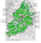
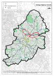
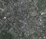
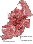 The map shows variation in accessibility to natural capital and ability of the natural environment to ‘supply’ or meet the needs of local population. The underlined areas show the existing gaps in green infrastructure.
 -
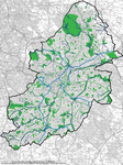 Green and blue infrastructure
 -
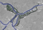
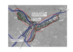
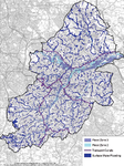 Blue network
 -
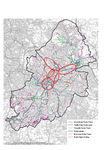 Public and light traffic plan that shows potential for canal corridor to link the scattered light traffic paths
 -
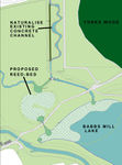 The plan of reconstructions in Kingfisher Country Park that will improve water quality that flows from the urban area
 -
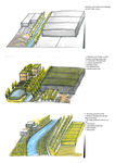
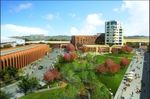 The large part of the Longbridge center project involves making alterations to the culverts of the River Rea that will help mitigate floods and will prepare Birmigham for climate change.
 -
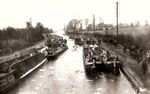 The view from White Lion Bridge of 1930 present canal as very busy traffic corridors.
 -
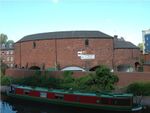 Hidden away The Roundhouse building is virtually unchanged; a surviving piece of the city's industrial and civic heritage and listed in recognition of its architectural and historic significance.The design of The Roundhouse took advantage of its strategic location as a canal-rail interchange, with the railway to the north and canal to the south.
 -
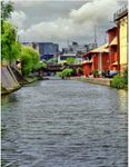
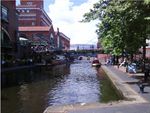 The view on Gas Street Basin that has been buzzing with constant activity, day and night, as cargoes were loaded and unloaded to supply local factories with raw materials. The buildings are still here where as now access to the canal ensure active social live and access to recreation sites.
 -
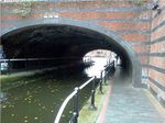 A comparison of green infrastructure along the canals with distance from the city center - city center.
 -
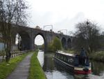 A comparison of green infrastructure along the canals with distance from the city center - suburbs.
 -
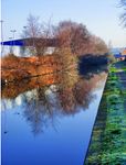
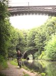 A comparison of green infrastructure along the canals with distance from the city center - outside city limits.
 -
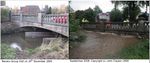 Comparative photos of increase in water level during the floods in Birmigham
 -
 The Canal and River Trust is the central organization in protection, maintenance and education on canal history and environment.


Analytical drawings
- Character of the canals - http://prezi.com/a9m436m8tvyo/?utm_campaign=share&utm_medium=copy
- Analytical Drawings
-
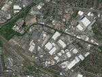
 The canals were the main transport arteries of the city and a skeleton for urban structure. Today the Birmingham is the central for transition and formal industrial sites are used for storage. Thus main canals run within the areas that are not aesthetically attractive and unsafe.
 -
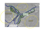
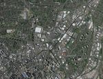
 Most critical parts of Birmingham that lack greenery and negatively affect urban micro climate.
 -
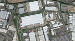 Examples of surfaces in the areas of store housing along the canals
 -
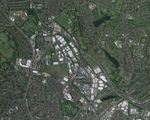
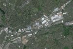
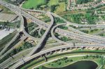
 The function of the canals in past is replaced today with the road network. The range of main UK motorways lead through Birmingham and form large motorway junction like UK Spaghetti Junction that was built over the canal.


Green Infrastructure benefits for this site
Water is a key element for rich biodiversity as well as it has high recreational value. For example in urban conditions water surface attracts insects that in turn brings flying bats and birds. For the people according to the range of theories in environmental psychology water is an important restorative element in stressful urban environment. Thus Blue network naturally provides range of ecosystem services as well as it ensures connection of the city center green areas with the countryside. Along with that there are range of issues that decrease the value and functionality of it. For example limiting the contamination of the streams will not only ensure the stability of ecosystem processes but may provide alternative recourse of water supply. The range of grey areas along the canal is an opportunity for creating of pockets parks or larger recreational sites and placing water bodies or allowing water to meadows that may decrease pressure during the floods. The areas next to the canals have a potential to become highly attractive residential site as well, that in turn will make canal sides more safe. The existing paths along the canals can be considered and planned as a part of a larger path network for light traffic within all Birmingham. Consideration of all these issues may strongly affect city image and ensure better quality of life for its residence.
Potential for multifunctionality
Green infrastructure has typically multiple functions. What could be achieved for your site in this respect?
Social
- aesthetic and spiritual value
- sense of community and shaping the city through social interaction
- preservation of cultural-historical characteristic of the city
- tourism and recreation
Economical
- alternative water resource
- reduce financial consequences of global warming
- flood alleviation
- higher property values
Environmental
- enlargement of habitat for wildlife within urban environment
- strengthening ecosystem resilience
- mitigation of heat island effect
- ensuring ecological corridor performance and its linkage with green belt
- making more efficient light traffic network
Projective drawings
How would you like this case to change in the near future? (in 1-2 years)
City Center
- giving new function to abandoned industrial buildings (residential, first floor - social and amenities) to make canal sides more lively and save
- good visual connection between canal and buildings to ensure safety
- green embankment
- installation of green roofs
- placing trees in parking areas
- widening canal path to accept larger amount of light traffic vehicles and pedestrians
Suburbs
- clearing area next to the canal side from warehouses, spreading greenery
- make warehouses area more dense and functional
- implementing law that will oblige use of green roofs for (store) buildings with large roof surfaces and solar panels
- placing water meadows next to the canal
- restoration of industrial heritage for public use
- old industrial objects can be used as green installation that increase biodiversity
- planting trees
- establishing more outdoor facilities along the canal
- creating habitat for wildlife
- urban agriculture
And how could it look like in 10-15 years?
City Center
- taking measures for adaptation to global warming
- placing research areas on the roofs of scientific center
- adapting attics for residential use
- increasing amount of green surfaces, including roofs, walls
- placing allotments
- placing pocket parks
- placing plants as a filters for protection cleaning water in canals
Suburbs
- placing research plots
- establishing of urban farms
- flooding meadows that can be used as temporal meadows
- transforming canal to the river with water meadows
- building earthen wall and planting with trees for placing light traffic path and preventing flooding
- aquaculture (algae)
- reed for cleaning water and production of energy
- Projective Drawings
-
 Existing pressure on green infrastructure
 -
 Principal changes in land use and accessibility improvement
 -
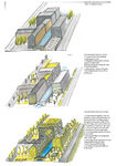 Projective drawing in 1 year
 -
 Projective drawing in 20 years


Summary and conclusion
Existing network of canals in Birmingham has a high potential in providing range of ecosystem services, and local government has started range of projects that will increase environmental value of individual spots. But to make it more functional the canal network should be seen as one element and its development discussed in relation to the areas the waterways are running through. The key problem is the congestion of transport in the urban setting and main role of the city as an entrepot for transition between North and South of UK. Where as the first priority in city development should be provision of healthy and high quality environment for its residence. The Spaghetti junction is the best evidence of prioritization of traffic infrastructure over blue infrastructure and seen it as an obstacle. Where as its active introduction in urban environment may be a way to solve range of problems that Birmingham city is struggling now including local energy generation, improvement of air quality, food production, bringing to light cultural heritage, provision of recreation facilities, water supply and mitigation of consequences related to climate change
Image Gallery
Please add further images/photos here
- Image Gallery
-
 Storehouses on waterfront
 -
 Canals provides visual corridors
 -
 Windows towards waterfront
 -
 Witton area
 -
 Tyseley area
 -
 Tyburn road
 -
 Duddeston area
 -
 Aston area
 -
 Birmingham city centre
 -
 Canal under Spaghetti junction.jpg


References
- http://www.canaljunction.com/canal/birmingham_navigations.htm
- http://billdargue.jimdo.com/placenames-gazetteer-a-to-y/places-d/digbeth/
- http://en.wikipedia.org/wiki/Birmingham_Canal_Navigations
- http://en.wikipedia.org/wiki/History_of_Birmingham#cite_note-240
- http://www.birminghampost.co.uk/lifestyle/birmingham-city-council-bid-triple-6396846
- http://www.birmingham.gov.uk/greenlivingspaces
- http://www.bbc.co.uk/birmingham/your_birmingham/walk_through_time/07.shtml
- https://canalrivertrust.org.uk/canals-and-rivers/birmingham-canal-navigations
- http://www.birmingham.gov.uk/citycentrecanalcorridor
- https://www.google.com/maps/d/viewer?msa=0&mid=z8BscB1MtUUo.kusViGZdjOHg
- http://www.birmingham.gov.uk/greenlivingspaces
- http://www.birminghampost.co.uk/business/creative/birminghams-hidden-spaces-roundhouse-serves-8336648
- http://www.kingsnorton.info/places/canal_buildings.htm
- http://johncotton.org/tag/babbs-mill/
- http://www.suttoncoldfieldrural.com/uploads/1/9/3/2/19322181/birmingham_development_plan_2031_pre-submission_consultation__appendix_7.pdf
- http://www.birmingham.gov.uk/cs/Satellite?blobcol=urldata&blobheader=application%2Fpdf&blobheadername1=Content-Disposition&blobkey=id&blobtable=MungoBlobs&blobwhere=1223507752047&ssbinary=true&blobheadervalue1=attachment%3B+filename%3D34420Flooding_advice.pdf
About categories: You can add more categories with this tag: "", add your categories