Green Infrastructure 2014 Working Group L - Case Study 1
---> back to group page working group L
Green Infrastructure potential of Zagreb
| Name | GI potential of Zagreb | |
| Country | Croatia | |
| City | Zagreb | |
| Authors | Ana Žmire | |

| ||
|
| ||
Rationale: Why is this case interesting?
Due to the rapid growth of habitants in the past 100 years natural areas have been pushed out of the city of Zagreb and they were replaced with building blocks with no good quality open green areas. In 1899 a decision to regulate the flow of the Sava River resulted in taking the river away from city’s habitants.
Great potential for green infrastructure in Zagreb lies in so called green fingers that along with streams descend into the city. Unfortunately, most of the streams were channelized and covered and green fingers are rapidly being destroyed due to the city’s growth.
The main goal of this case study is to explore the possibility of connecting what is left of the green fingers and streams, through a network of corridors and patches of green infrastructure elements, embedded into the urban matrix, to the Sava River, as well as to propose a solution of returning the river to the citizens of Zagreb giving the use to its forgotten banks.
Author's perspective
As a graduate student of landscape architecture it is hard to watch forgotten open spaces together with the ones that are getting more and more neglected each day. This is especially the case of the Sava River that is “imprisoned” between two embankments along with its vast space that has a great potential but no use.
My major interest is in landscape planning and implementation of landscape ecology principles in order to harmonize development and protection, in a way that follows the principles of sustainable development to meet the needs of present and future generations. I am also interested in sustainable water management and replacing gray infrastructure with green solutions that would heal our streams and rivers.
Landscape and/or urban context of your case
Zagreb is the administrative, economic, cultural, and scientific center of the Republic of Croatian. It developed on the southern slopes of the Medvednica Mountain, north of the Sava River, from two neighboring settlements, Gradec and Kaptol, which form the historic center of Zagreb.
Climate
Zagreb’s climate is temperate continental. Summers are hot and dry with average temperatures of 20 ° C, while winters are cold with average temperatures of 1 ° C. The highest rainfall is in the late spring, early summer and autumn, and least in the winter and early spring. There are no extremely dry or wet periods.
Location
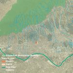
Favorable geographic position in the southwestern corner of the Pannonian Plain, between the Alpine, Dinaric, Adriatic and Pannonian regions, is the cause that Zagreb is located at a junction of roads between Central and Southeastern Europe and the Adriatic Sea. Specificity of Zagreb’s position is determined by three valuable natural entities:
• the Medvednica Mountain in the north, which together with mountains in the west and in the south form the green frame around Zagreb
• the river basin of Sava River that is rich in water, water surfaces and valuable arable land
• and the Sava River.
Development
Unlike most central European cities Zagreb did not develop on the coastal terrace of its river, but at the foothills of the Medvednica Mountain, that provided protection from river flooding among other things. In the past 100 years, although belonging to smaller European cities, Zagreb experienced one of its biggest expansions with an increase in population from 40,000 to 800,000 inhabitants. Development and expansion of the Lower Town and villages in the valley of the Sava River, during the second half of the 19th century, was restrictive due to the unregulated river that became one of the main limiting factors of the intense transformation of the Sava floodplain. Especially in the urban municipalities south of the railway where new residential areas were rapidly growing, influenced by the arrival of the railway (1862) and the initial stages of industrialization.
A historic decision of regulating the Sava River through Zagreb in 1899 completely changed the conditions of city’s development and in the 1950s directed it, with raising new residential areas, south of the Sava River.
Medvednica Mountain
Zagreb is one of the few European capitals that have a Nature Park in its immediate vicinity as big as as Medvednica Mountain. Most of which (17 938 ha) was declared a Nature Park in 1981, in an attempt to protect its values. In addition to a high ecological significance, given the relief, climate and vegetation, for the life of the inhabitants of Zagreb, it also represents an important forest and recreational space. The forests of Medvednica descend almost to the very center of Zagreb, and besides peace and greenery, it is rich in diverse wildlife. Unregulated building gradually consumed forests that were spreading towards and through the city, severing them from the homogeneous whole and disturbing its natural balance.
Medvednica Mountain is also rich in streams that descend from it and pass through Zagreb towards the Sava river. Although they have modest capacity, many of them supply smaller settlements with water and are a part of the city’s water supply system. There are 45 streams, but only 17 of them are open channeled and the other 28 covered with city’s urban tissue. In the past these streams were open and had a high environmental value, especially during the humid summers, as well as the economic and social value because they were the generators of social and economic life (baths, mills, factories). Because little or no awareness streams have gradually become a source of major hygienic problems and due to lack of maintenance flooding has become more frequent. Most of the streams today flow through channels, beneath the city, that were planned in 1930s and the rest that maintained open create spaces of questionable quality.
Sava River
Until 1899 when a decision to regulate the river was made, Sava River was a tangle of smaller streams and tributaries whose position constantly changed and after 1899 the river bed as we know it today was constructed. Frequent floods sometimes spread all the way to the historic city center, destroying everything in its path and causing major damage. As a part of the regulation the old oxbows had to be filled, river banks of the main flow needed to be determined, the depth of the riverbed equalized in order to enable sailing and ensure better drainage of high waters, and protective embankments built on both sides of the river.
The existing flood defense system is designed in such a way that the most of the Sava’s high waters pass through the city of Zagreb. Flood zone extends 100 m along both sides of the 100 m wide riverbed and is bordered by dikes. The excess water, which cannot pass through the city, is directed into the Sava-Odra channel and further into the Odra field. By 2003, several concepts of Zagreb on the Sava River were developed, but all included high waters passing through the city. Newest concept that was developed in 2013, and unlike the previous, proposes redirection of high waters past the City of Zagreb through the Sava - Sava channel.
Despite the many concepts that tried to return the river to city’s inhabitants, questions like - What should be the use for that unused green belt along the river? Residential, commercial, or "natural"? - remain unanswered.
- widths="150px"
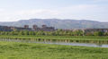
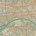
Sava River with the Medvednica Mountain in the background

Green fingers descending from the Medvednica Mountain beeing destroyed by housing development
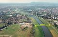
Sava River
Sava - Odra channel


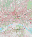
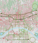
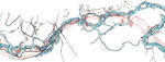
Analytical drawings
- Analytical Drawings
Relationship between major potentials for GI implementation (streams along with green fingers and the Sava River)
Main city roads as a potential for implementation of GI corridors
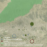
Sites for improvement and further development with GI elements
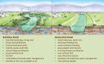
Comparison of natural and regulated river


Green Infrastructure benefits for this site
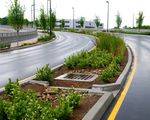
Green spaces, whether connected or not, must be seen as providing facilities or services for the people who live amongst it. Its real potential will only be realized if activities or operations undertaken in or on the green space are supported by the whole local community. Through the implementation of green infrastructure elements such as: green alleys and streets, green roofs, rainwater harvesting, wetlands, bioswales, raingardens, bioretentions, permeable pavement, green parking and many more, could provide many benefits for the city of Zagreb.
Climate change – reduced urban heat island effect and flood risks, improved water quality through sustainable stormwater management that controls water at the source and an increase of available water supply, reduction of atmospheric CO2 and improved air quality.
Health and well-being - increased life expectancy and possible reduction of health inequality, improved levels of physical activity and health, improved psychological health and mental well-being, increased recreational opportunity, reduced noise pollution.
Economic growth and investment - inward investment and job creation, increased land and property values, regenerated local economics, reduced water treatment needs, reduced grey infrastructure needs, reduced energy use.
Land regeneration - possible regeneration of previously developed land, improved quality of a place, increased environmental quality and aesthetics.
Wildlife and habitats - increased habitat area and populations of some protected species, increased species movement.
Stronger communities - better social interaction, inclusion and cohesion through community participation in public management, as well as providing opportunities for education, training, volunteering and capacity building.
Potential for multifunctionality
- widths="800px"

Projective drawings
- Projective Drawings
1st phase - Implementation of GI elements on the city's central axis
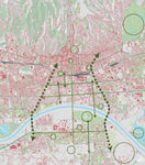
2nd phase - Implementation of GI elements along main transverse city roads
3rd phase - Implementation of GI elements along main longitudinal city roads
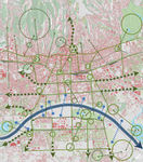
4th phase - Interconnection of GI corridors and patches
Greener streets
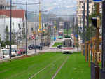
Greener rails
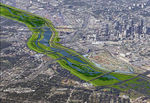
Attractive river
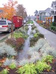
Sustainable stormwater management


Summary and conclusion
Intertwining the city with corridors of greenery, that serve for movement of people and goods, is the foundation of urban mobility as one of the most important urban processes in the identification of population with its city. The idea is developed from the concept of the city as a network of green spaces of different types of function: urban parks, green squares, green alleys along the roads, series of related parks, water parks, sports and recreational parks, greenery in the free plan of newly built settlements. A great value and importance in this regard are areas along the Sava River, which will be possible only after the city authorities recognize the importance of the Sava River in the daily life of Zagreb’s inhabitants. In that way the conditions for the spatial correlation of the city would be made, and newly created urban spaces and parks with unique qualities would greatly influence the creation of the new image of the city of Zagreb.
Streams could also become new generators and focal points of the modern city as an introduction to new priorities of a modern society, which due to the lifestyle changes no longer insists on industrialization, but on preservation of the greenery and natural specifics. There is also a possibility of planning the forgotten and closed streams and linking them to the existing green fingers as a system of public urban areas. Sava River and spaces along it must not be disconnected from the network, since Sava together with Medvednica Mountain forms the landscape basis of the city of Zagreb and its wider area. The implementation of the green infrastructure into a densely built-up area raises the price of the surrounding land and real estate, gives a new image to the area and improves the life quality. Today, quality green areas are one of the most valuable generators of social and economic development.
Image Gallery
- Image Gallery
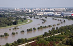
Sava River during high water level
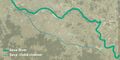
Flow of the Sava River before regulation
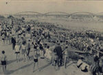
Public beach on the Sava River at the end of 19th century
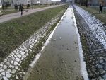
Trough of the Vrapčak Stream
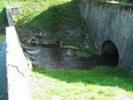
Medveščak Stream entering its underground channel
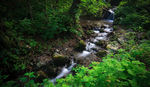
One of the streams flowing through Medvednica Mountain
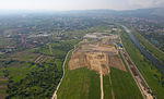
City landfill
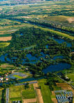
Savica Lakes - Remaining oxbow of the Sava River


References
- Center for Neighborhood Technology (2010). The Value of Green Infrastructure - A Guide to Recognizing Its Economic,Environmental and Social Benefits. Center for Neighborhood Technology, Chicago. http://www.cnt.org/repository/gi-values-guide.pdf
- Crnobrnja, Neven (2005). Zagrebački savski mostovi. Građevinar 57 (2005) 12, 977-985
- Forest Research (2010). Benefits of green infrastructure. Report by Forest Research. Forest Research, Farnham. http://www.forestry.gov.uk/pdf/urgp_benefits_of_green_infrastructure.pdf/$FILE/urgp_benefits_of_green_infrastructure.pdf
- Landscape Institute (2009). Green infrastructure: connected and multifunctional landscapes. Position statement. Landscape Institute, London.
- Slukan-Altić, Mirela, (2010). Povijest regulacije rijeke Save kod Zagreba i njezine posljedice na izgradnju grada. Hrvatske vode 73 (2010); 205-212.
- Šegota, Tomislav, Filipćić, Anita (2007). Suvremene promjene klime i smanjenje protoka Save u Zagrebu. Geoadria 12/1 (2007) 45-58.
- Štulhofer, Ariana, Barišić Marenić, Zrinka, Uchytil, Andrej (2010). Kupališta i drugi sportsko-rekreacijski sadržaji uz rijeku Savu u Zagrebu. Hrvatske vode 73 (2010); 205-212.
- Živaković-Kerže, Zlata (2010). Osvrt na zakonske osnove vezane za odvodnju i regulaciju Save. Hrvatske vode 73 (2010); 205-212.
About categories: You can add more categories with this tag: "", add your categories