Green Infrastructure 2014 Group F - Case Study 4
---> back to group page working group F
Implementing Green Infrastructure in Hashemieh Mountain Area in Mashhad
| Name | Hashemie Mountain Area | |||||||||||
| Country | Iran | |||||||||||
| City | Mashhad | |||||||||||
| Authors | Maliheh Shahghadami | |||||||||||

| ||||||||||||
| {{#widget:GoogleMaps | width=300 | height=240 | lat=36.29588897622758 | lng=59.49521864511712 | zoom=10 | centermarker=yes | maptypecontrol=yes | overviewmapcontrol=yes | largemapcontrol=yes | scalecontrol=yes
}} | ||
Rationale: Why is this case interesting?
Population increase and migration (from smaller cities and rural areas) in recent years has become a phenomenon in Mashhad. This problem leaded to an unforeseen development in the edges of the city. The study area is located in the southwest of Mashhad. This area is limited from Binalood Mountain ranges from south which was predicted as barrier for city development in previous comprehensive plans. The city expansion was predicted to the northwest side of the city. But in recent years we have seen the unauthorisation construction on the hillsides and on the mounts. This new development is done without considering aspects of sustainable development. Field work and evaluation the studies represents an irreparable injury to the environment, particularly watercourse sources. This is a hazard for Mashhad because every day the mounts are been destructed, which destroys the pleasant view. There are also several problems in this district people are facing to, such as air pollution and other environmental pollutants, fatal traffic problems, marginalization.
Author's perspective
Hashemie mountains are a place to building houses and commercial complexes, when the hillside can give us a chance to get closer to sky. For confronting to this problem we need to implement Green Infrastructure and make a green district with the use of renewable energies.The mountains and hillside overlooking the city can be natural attraction and restore which can help people scape from machinery life, it can also help the city to breath.

Landscape and/or urban context of your case
Biogeography
Mashhad: Mashhad is the second largest metropolitan area in Iran with a population of 3,131,586 million people and covers an area of 29,580 hectares. It is located in the valley of the Kashaf River and between the two mountain ranges of Binalood and Hezar-masjed. In addition, this metropolitan area as the center of Khorasan Razavi province shares the population of 78% and had a significant increase from 1996. Mashhad is a religious city for Muslims and has over 20 million pilgrims and tourists per year.
Hashemie mountain area: The study area is located in southwest of Mashhad in part of the natural geography of the Kashaf river valley. There are two basic element of environmental, Chehel baze watercourse in the north and Binalood mountain ranges in the south areas.
History: Natural environment and ecological structure has an important role in shaping the city. The topography of the city affects distributes applications and critical infrastructure. Physical Development and historical geography in the Southwest area doesn’t have long antiquity. This area historically is promoting a new field in urban environment and its growth rate is accelerating. Since 5 years ago constructions had been increased and two highways have been constructing in this area. One is Namaz Highway which goes through the chosen area and the other one is Southern branch that is not yet complete. It is behind this area in the middle of the mountains which still is not complete and will connect east side of Mashhad to the west country side in near future.

Social and cultural features: Number of inhabitants in this area is around 419 thousand people. This is 17.3% of the city population. Average annual population growth in this district in comparison to the whole city is 2.6%. From the social point of view this area is habitat for middle calss and upper class citizens. Study area in terms of tissue composition has plaid pattern and streets have east-west and north- south direction. Respect the composition of mass and space, masses are mostly interconnected and is free of spaces and equipped public areas.
Tourism and Leisure features: the communication accesses to Torghabe and Shandiz is one of the features of this area. Hashemie area has been choosing for creating a new tourist and entertainment center. The Mounts near to Hashemie are very beautiful area and perfect for climbing. Kouhsar complex and Kouhsar Mal which are called 'Mashhad roof have a wide view to the whole city. Kouhsar Complex is constructed on one of the mounts in Hashemie. It has a good and clear view from any parts of the district. There is another project also being constructed as 'Kouhsar Mall' near to the complex. Khorshid Mountain Park is the other hotspot.

The physical characteristics: There are some visual corridors of the city's south wall and from Binalood mounts to this district has provided major opportunity to enhance the visual quality. Construction in this area is mainly due to the topography and natural elements. In terms of performance elements are affected by water flow of terrain.
Geology: The southwest area is located in the Mountain ranges of Binalood and thrust faults and thrust plates are the main geological structures. The main portion of the watershed in south of Mashhad are previously met sediment stones. So met sediment stones are mainly potential areas for flood.
Topography: Most of lands are with a slope greater than 10% in southern city and they are natural border of the town.
Rainfall: Rainfall pattern in Mashhad is Mediterranean; it means that most of the rainfalls happen in winter and continuously in spring. The average of rainfall in (2000-2010) was 257, 1 millimeter. The difference between maximum and minimum of Mashhad rainfall was 56, 4 millimeter.
Temperature: The average annual temperature in mashhad between 2000 and 2010 was 13.8 ° C. The mean temperature difference of day and night within different months of year was between 12- 16° C. The mean temperature in summer is 23.5° C and in winter is 4.2° C.
Frost days in Mashhad: The average of frost days in Mashhad is 94 days. Maximum frost length is in winter and longest period of frosting is in January for 27 days. The minimum frost is in spring less than one day (0/8 day) which happens in April.
Humidity: Mashhad weather is partial to dry areas. The average annual humidity is 56%, the maximum humidity is in February and the minimum humidity is in July.
Winds: In Mashhad desirable winds are in the east-west direction and undesirable wind is south wind which has the speed of 5.57 meters per second and tackle barriers should be used against it.
Sunshine: The average of sunny hours is in February with the average of 5 hours sunny and the maximum is in July with the average of more than 12 hours.
Land texture: Land texture in this area is a mixture of gravel, sand and in small part clay. Some areas are rocky outcrops.It can be seen in soil texture maps that in the west of southern highlands bordering soil texture is sandy and sandy zone extends from surface to depth.
Groundwater and surface water: The study area has 33% of watercourse of the city within (11 watercourses). Drainage areas in the southern part of Mashhad are all within the Binaloud zone and the maximum depth of groundwater level in this area is related to 'Pachenar ' and 'Nohdare' subareas. Groundwater level in southwest had dropped. This is because of recent droughts and the lack of supply volume by 'Golestan ' and 'Torogh' rivers and also indiscriminate harvesting of the water course.
Characteristic: Positioning the southwest area on hillside and on the south mounts and also urban developments in this area is suitable for abandoned spaces. Moreover has become abandoned spaces. Buildings are mostly constructed behind the watercourses and have not had any significant consideration to these important elements of nature. In the comprehensive plan south and north edges of the area was defined with natural features, but destruction of foothill lands and construction development in this area has spoiled the south border features.
flora habitats:Due to good weather and temperate zone this area has appropriate flora habitats:
Tan acetum, tea, ziziphora tenuior, thyme, cumin, achillea flower, barberry ,chamomile, french lavender, almonds and pistachios, sumac, marshmallow, tragacanth, angelica, sisymbrium irio, peganum harmala, lemon balm, mushroom, shallot, succor and eremurus. Rhubarb is also the oldest and the best quality plants in these mountains and in some parts 'Aras' trees cover is tight manner.
fauna:• Because of the diversity of the plants, this area is a suitable habitat for faunas like: ram, ewe, deer, eagle, falcon, partridge, pig, hog, panther, snake, mouse, jackal and fox.
'Khorshid Park'
accessiblity to Khorshid park: There are 3 ways for entering Khorshid park: (Entrance 1) is accessing by cars.
The other ways are steps on three mountains of Hashemie, with its 400 stairs are also appropriate for those who are interested in safe climbins as ( Entrance2).Research and location of the first city's Telecabin has been finished and Mashhad will soon have a Telecabin route as 1700 m distance.This is located as (Entrance 3). The station's origin is Khorshid park and a height of 2300 meter of beautiful Zhu peak is the end of the Telecabin route.
Land use: 50% of the park is well-defined as 'Quiet park'; pristine and untouched environment and the other 50% will composed of a variety of other land uses such as: wildlife pit a place for deers, children garden, Garden of Memories, Valley of wildflowers, Mountain bike track, Multi-purpose sports pitch and art plaza with a fountain between stairs. It has been also planned to construct energy tunnel, landscaping and increased green space, constructing artificial Lake in Khorshid mountain.
Plant species: There are diffrent kinds of plants in khorshid park such as: pine, cypress, acacia and berry. According to schedule, every year, 10 million trees will be added to the existing trees.
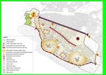
- Illustrations
-
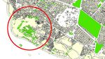
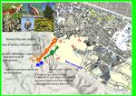
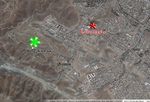 Hashemie Satellite Image
 -
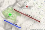 Main Roads
 -
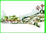
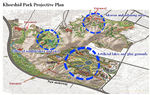 Khorshid Park projective plan


Analytical drawings
- Please use analytical drawing for visualising the conflicts/potentials of your site
- Analytical Drawings
-
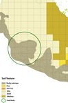 Soil Texture
 -
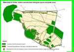
 Greeen Spaces
 -
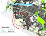 Watrecourses
 -
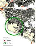 Aqueduct Recourses
 -
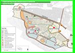 Analysis Map
 -
 Analysis Map
 -
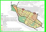 Land use Analysis


Green Infrastructure benefits for this site
Connectivity: By implementing the green infrastructure in this area beside the two main motorways and local streets will be a desirable place for passing through and improves the relation between people and the streets. It also improves mental, physical, spiritual and social health of the citizens by choosing these streets for walking and enjoying the perfect nature.
Multifunctionality: This area could be part of the city's most important and distinctive position in terms of performance for the whole town.
Social benefits: Of the main uses of the green district is the expansion of coexistence with nature and increase mental happiness and health of its citizens, also reaching the standard of green space for every citizen due to implementing green infrastructure.
Economic benefits: Use of passive landscape can help with cooling system(Heating problems in winters and chilly days As there is located in height and there is no protection against un desirable south cold weather ). This area also could be a tourism center based on the recreation the tourism environment.
Environmental benefits: Implementing green infrustrection has wide range of environmental benefits which could be achieved as: 1- Helping to clean the air of pollutants produced by cars and small industries in the west area of the city. 2- Preventing and limiting the consequences of increasing marginalization, which is extremely big problem for Mashhad. 3- Making a desirable perspective to the hillsides. 4- Immunization biological fields against floods.5- Optimal use of environmental capacities in relation to urban areas. 6- Collect storm water and organizing the watercourses through bio filtration for better performance. 7- Using drained water could be saved for vegetable planting.
Potential for multifunctionality
•Streets and open spaces have appropriate heat conditions if they have moderate humidity. Setting the humidity in the streets of Mashhad is important due to the use of evaporative cooling. So the calculation of the water surface, grass and trees in urban is important.
•Existence of aqueducts and groundwater flow in the area is important. Water flowing from the rain in the watercourse mostly emanate from high and steep altitude. Followed by multiple watercourses and drainages passes away from the urban lands, facilities and residential areas. Bio filtration and waste recycling can be important for planting and reusing of water.
•Location of the buildings on hillside is important for water capturing and food growth.
•According to Vakilabad Boulevard as the main spatial structure and functional axis, and due to the lack of activity on the land and development potential and the importance of Vakilabad and the New highway to the recreational area( Torghabe and Shandiz), this area should be seen as the main structure and activity space in the city due to a green district to improve citizen's and pilgrim's phantasm.
•Local Parks can be the center of green infrastructure expansion in this area.
Projective drawings
* Short Term Projection (1-2 Years): In the next two years this area could have optimal use of environmental capacities in relation to urban areas by constructing local parks. A green district with green vision by constructing the protective belt from western to southern areas. Covering abandoned spaces and bringing safety to the neighborhoods. Rain water collection trough locating routing nets to collect surface water to immunization biological fields against floods. Encourage the anticipated pause spaces with human scale.
Long Term Projection (10-15 Years): Development of green infrastructure in the city edge and mountainous could eventuate settlement of entertainment, tourism, leisure and cultural activities in the west area which are connected to each other by main roads within this area and community center and their connectivity with green stripes areas. Making prevent uneven growth of undesirable constructions. This area could be part of the city's most important and distinctive position in terms of performance for the whole town with sustainable ecology.
- Projective Drawings
-
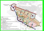 short term projection
 -
 linking green spaces
 -
 long term projection
 -
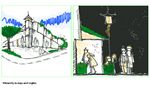
 View to Hashemie mountains
 -
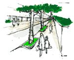
 Public spaces
 -
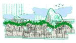 City view to mountains
 -
 Day and night vibrant
 -
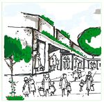
 Green streets


Summary and conclusion
- Sustainable development and interaction balance with surrounded environment and preventing devastating effects of urban development on natural environment is one of the developments goals. South areas of Mashhad can be part of the immediate and affecting environment for Mashhad trough functionality, aesthetic and environmental systems. This area has great potentiality to being specific green district in Mashhad as two basic environment elements are located there. Due to the topography of the area, construction pattern is not according to steep terrain and residential texture is torn apart because of coarse aggregate city scale. Balanced use of soil and water resources can lead this district to a healthy, green and sustainable residential and tourist center in near future.
Image Gallery
Please add further images/photos here
- Image Gallery
-
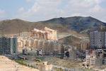
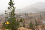
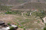
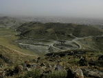 top view from Hashemie Mountains
 -
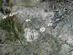 plant grows
 -
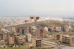
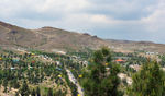
 residential buildings
 -
 kouhsar complex
 -
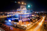 Kouhsar Mall construction
 -
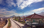 Khorshid park
 -
 Khorshid park
 -
 Khorshid park
 -
 Khorshid park
 -
 Khorshid park


References
- please add your references here
About categories: You can add more categories with this tag: "", add your categories