Green Infrastructure 2014 Group B - Case Study 2
---> back to group page working group B
Los Caobos Park + Botanical Garden
| Name | Los Caobos Park + Botanical Garden | |||||||||||
| Country | Venezuela | |||||||||||
| City | Caracas | |||||||||||
| Authors | Irene Jackson | |||||||||||

| ||||||||||||
| {{#widget:GoogleMaps | width=300 | height=240 | lat=10.4993413 | lng=-66.89381449999996 | zoom=15 | centermarker=yes | maptypecontrol=yes | overviewmapcontrol=yes | largemapcontrol=yes | scalecontrol=yes
}} | ||
Rationale
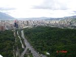
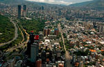
Caracas is a valley, entirely surrounded by green,the most important mountain of the city is National Park and a reference of every caraquenians. Caracas is a fragmented city, created by patch, creating multiple types of street networks, and hurt by the highway, making impossible cross north-south connectivity. In Caracas found a forgot and dirty river, where untreated waste of the city are deposed, which sometimes in rain season overflows, collapsing the roads and making grievances. These are general characteristics of the city, and casually, found all in the proposed study case, connected by a large greenery mass: Parque los Caobos and in the other side of the highway: Botanical Garden of Caracas. This area is the geographical center of the city and this area was focus of investments in last decades, that is why we found a lot of important pieces of history, that gives this complex and diversity to the city and specially to the plot; The most common street network are colonial grid, isolate residential building, and informal construction. Represented all next to the park. In the south of the Botanical Garden is the most important modern architectural piece is University City, a enormous complex with high cultural and historical value. On the west border, The highest tower of the city is called "Parque Central" 255m, and the biggest cultural complex of the city, Bellas Artes Museum, Sciences Museum, Teresa Carreno Theater, University of Arts. And inside the park in this area, the buildings of El Sistema, National System of youth Orchestra. Although this park has too many interesting things close, a privileged location in the city and sizable, this park nor the Botanical Garden represent any of the GI concepts.
Author's perspective
I have a degree in architecture, I always have being interested in the environment and urbanism, that is why I want to work improving the urban landscape. I'm from Caracas, born and raised, I have studied in "Universidad Central de Venezuela", very close to this place, and casually in the physical center of the city, for me, one of the most disconnected and chaotic places in Caracas. I found potential in this place because in this little area one can find a lot of aspects to create a good Green Infrastructure, river, greenery, cultural places, prominent topography, etc., and the challenge to make this place worth, because in plan is a big green area, but when you walk around you don't feel all these benefits. That's why I think is being missing a great opportunity for the people of the city can enjoy the possibility of having a green pulmon in the middle of the city.
Landscape and/or urban context of your case
- Biogeography, cultural features, overall character, history and dynamics
- Illustrations: maps; sketches; short descriptive analyses
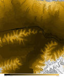
- Illustrations
-
 your visual
 -
your visual
-
your visual

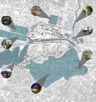
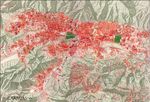
Analytical drawings
- Please use analytical drawing for visualising the conflicts/potentials of your site
- Analytical Drawings
-
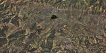
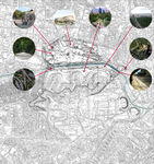 Important buildings inside the plot
 -
 Elements outside the plot
 -
 Uses
Uses -
 Topography


Green Infrastructure benefits for this site
Despite this area is in the middle of the city, connectivity is the most potential aspect in this case. First, connect the area itself, north part (Los Caobos Park) with the south one (Botanical Garden) to create a real gig green mass, creating a green heart.
This new green mass could benefit itself the connectivity with other potentials green infrastructures in the city, the Avila Mountain in the north and Los Proceres Park in the south. Which is also a riverside, in this north south connection, one can find several pocked parks which will facilitate the travel between destiny points and could create an urban ecological corridor.
The ecological north-south corridor will include management hydraulic activation of the rivers “Quebrada Mariperez and “Rio Valle”, preserving as well its bellowing ecological system and wildlife. This corridor could also include elements of public space, bike paths and passive recreation, in order to increase the usability and environmental and living conditions of the area.
This green mass could be understood as gears of a complex system center on it. In this district, where the park is located, live around 150.000 people, it means the social aspect is very important, just thinking about the local impact. The existence of different urban network increase the social diversity; favelas, isolate residential building, and unfamiliar houses. All typologies could have, in its respective scale and dimension, renovations in order to be coherent to the new technologies and supporting the new system the park and corridor offer. This area is culturally rich, a lot of buildings with historical value and cultural center will improve the touristic interest on the area, increasing as well the economic value of the district.
Potential for multifunctionality
Los Caobos Park and Botanical Garden have several multiple functions potentials, proper use of the cultural, social, greenery and economical sources can integrate very important areas of the city and provide benefits, such as increase lifestyle (providing recreational-educational spaces for dismissed communities), create better conditions for biodiversity, improve river conditions (well water treatment), protect biodiversity, connect with other green infrastructures areas to create a complete green system that will benefit the hole city.
Projective drawings
- How would you like this case to change in the near future? (in 1-2 years)
-Achieve integration of both parks, in the first phase with uses connections and increase of biodiversity in the area.
-Achieve the approach and involvement of neighboring communities, to create social comprehension of the area and benefits, maximize the use and development of the park.
-Achieve walkability in the area, improving street network with sidewalks, pedestrian path and bike routes to connect the city north-south.
- And how could it look like in 10-15 years?
-Create alternatives of transportation in this area to dispense with the highway, at least in this area.
-Improve public transportation system. Bus and tram connections north-south and create cable way to connect both cable way of the city.
-Achieve River improvement, gain leverage of the river condition in the city.
-Achieve the connection of different areas of green infrastructure in the city.
- Projective Drawings
-
projective drawing
-
projective drawing
-
projective drawing
-
projective drawing
Summary and conclusion
- 100 words approx.
Image Gallery
Please add further images/photos here
- Image Gallery
-
 Caracas 1967
 -
 Caracas 1994
 -
 your image text
 -
your image text
-
your image text
-
your image text
-
your image text
-
your image text


References
- please add your references here
About categories: You can add more categories with this tag: "", add your categories