Green Infrastructure 2014 Group N - Case Study 5
---> back to group page working group N
Bastia farms, Cavenago d'Adda, Lodi, Italy
| Name | Bastia farms | |||||||||||
| Country | Italy | |||||||||||
| City | Cavenago d'Adda | |||||||||||
| Authors | Barbara Boschiroli | |||||||||||

| ||||||||||||
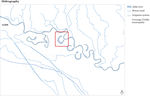
| {{#widget:GoogleMaps | width=300 | height=240 | lat=45.29438693047742 | lng=9.60909802543938 | zoom=10 | centermarker=yes | maptypecontrol=yes | overviewmapcontrol=yes | largemapcontrol=yes | scalecontrol=yes
}} | ||
Rationale: Why is this case interesting?
The area is placed along the river Adda, in the south of Lodi town . The area is actually inside an old branch of the river and is dedicated to the agriculture production. The context is high relevant from different point of views:
-for the environment, there are a lot of wetlands, some haunting reserves, rich river vegetation, beaches, banks and dykes
-for the economy, high agriculture use direct to cultivate mais and grass for cow farms to produce the milk in the Grana Padano DOP cheese network
-for the culture, there are some old urban villages with churches, villas, mills and farms
The area is next to the current river course and is submitted to several flooding episodes during all the seasons in case of abundant rain. The area is formed by rural active fields, corn and grass, two farms, for cows and milk, and a private building, which was the old river camp of the municipality.
Author's perspective
I am a landscape architect. I took an architecture degree with a final project related with urban planning and landscaping on a neighborhood in Milan. I then worked in a landscape firm based in Milan where I developed several strategic projects and landscape projects, in urban and rural environment. I took two specialization courses about Water landscape and Public space at the UPC in Barcelona. At the moment I am working as a landscape consultant for different architects and engineer in the north of Italy. The site was an old family property where I spent most of my childhood.
Landscape and/or urban context of your case
- Biogeography, cultural features, overall character, history and dynamics
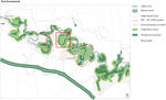
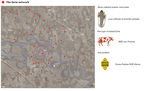
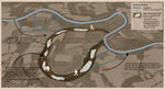
The Adda river is one of the main tributary to the Po, the main river in the north of Italy. The Adda borns in the Alps and crosses all the Lombardia region, passing through the Lecco lake, arrives in the flat area of the Pianura Padana. The Adda river is protected by two regional parks: the North, between the lake and Lodi town, and the South one, from Lodi town to the Po river. The two parks differ for the context the river crosses by and for the river course's features. The case study belongs to the South park area, where the course of the river becomes wider and with a lot of meanders, due to its lower speed across the plain( pic. 1). This part of the plain is dominated by the Adda and the Lambro river courses and by numerous canals for irrigation. The ecologic structure is based on the water courses and on their vegetation areas. (pic.2) The South park is characterized by a series of dead branches beside the meanders. one of the most famous of them is the Soltarico branch, originated from the flood in the 1976 when the river skipped the Soltarico meander and these 7 km of the old bed river became a series of wetlands and islands. Beside the Soltarico reserve there are other 5 natural reserve dead branches (pic.3). These protected areas (Life EU network) are important for their flora and fauna habitats, rare in the plain around. Even though the importance of these reserves, the Adda South Park has not many touristic structures: there isn’t a continuous path networks on the banks, there aren’t refreshment areas or other structures that could improve the human attraction. The case study is placed in one dead river branch and is the only one not transformed in a protected area. The Pianura Padana region is defined by its highly developed and mechanized agriculture. The landscape is dominated by the rhythm of the rural productions, corn and forage for the milk cows, and by the presence of small towns, villages and isolated farms, some of them quite old. Each of these towns and villages has its own church and bell tower, so even when the corn reaches its maximum height, in the end of summer, you can easily orientate yourself looking for the nearest tower or church.
- Illustrations
-
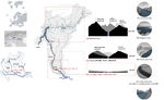 1_The big scale
 -
 2_The ecological network
 -
 3_The river and the dead branches of the river


Analytical drawings
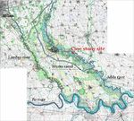
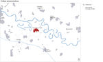
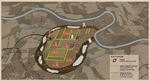
The case study (pic. 4) is located between two small villages: Cavenago d’Adda and Rubbiano, and it belongs to the municipality of Cavenago d’Adda. Cavenago d’Adda has almost 2500 inhabitants and is placed on the south of the Adda river, on the top of a river terrace, on a higher level than the case study (pic.5). The case study is formed by a dead river branch and a series of rural fields. The river branch has a U shape and is abandoned, formed by a series of wetlands, not stable, and spontaneous woods and bushes, with a lot of weeds plants. The area inside the U shape is a flat plain belonging to a farm property. The area is hightly cultivated and the landscape is really monotonous: the fields are only for corn and forage, cultivated to feed the cow for the milk production. The corn is sown during the early spring, irrigated during the summer and collected in the early autumn. During the winter time the ground is manured with the dung (from the cows). The cultivate production applies the rotation of the cultures system, alternating corn and forage with ryegrass. The agriculture system is highly developed and mechanized: all the steps and the processes are made by machines. The vegetation level in the rural fields is really poor: just reeds along some canals and some isolated trees or group of trees. The farms are placed along the main road that connects the two river side and cross the site in the middle. The farms have a two story building used as a house for the farmers and workers and several modern structures to house the animals and the machines. Some of these structures were built in different steps and with different materials, in a messy way. Inside the site, placed next to the river beaches, there is an isolated building currently used as a holiday house from the farmers. This building was built in the thirties of the past century from the fascist regime and was completely transform during the eighties. The building was used as a children river camp and all the boys and girls from the surroundings towns and farms were hosted daily during the summer to practice gymnastics, open air activities and sunbathing.
The conflicts of the site could be summarize as following:
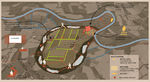
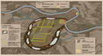
- the hight flooding risk (pic. 6-7-8) due to the meandered structure of the river and the morphology and geological characteristics;
- the abandonment of the dead river branch: spread of weeds, drying up of the wetlands and loosing of biodiversity;
-the highly impact of the agriculture system on the environment: methane pollution, depletion of vegetation and soil (pic. 10);
- the landscape impact of the rural buildings;
- a lack of facilities for the public fruition such as a continuous path networks or other simple touristic structures.
The potentials of the site could be summarize as following:
- great potential biodiversity in the dead branch areas and all along the Adda river (pic.9)
- great touristic potentials, also for the next year Universal Expo in Milan on the theme of Feeding the planet.
- Analytical Drawings
-
 4_The site
 -
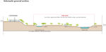 5_Schematic section of the site
 -
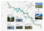
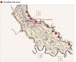 6_The flooding risk points/areas
 -
 7_Hydrology
 -
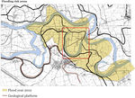 8_The flooded area
 -
 9_The main environment types
 -
 10_The rural economy
 -
 11_The urban centre and towns
 -
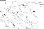 12_The main infrustructure


Green Infrastructure benefits for this site
Look again at the multiple benefits of green infrastructure - what could be achieved in your site and which are most relevant?
The GI benefits that could be achieved in the site are related with the following issues:
- Environment and ecology
The site offers a good chance to work on a different ecological aspects. First of all it will be possible develop a new, in the area, approach to the storm water management working with ground modeling. The idea is to model the topography in order to establish a system capable of controlling the water level and amount in the dead river branch in order to avoid the flooding of the areas and the buildings inside the branch. The system will be formed by a series of canals, basins and wetlands also important from the point of view of the biodiversity, with the restoring of local flora and fauna habitats. The water systems will become the structure upon which develop the vegetation system, enhancing the canals through trees and bushes or the wetlands with woods and aquatic plants.
- Economic
The site is entirely dedicated to the monoculture system of the corn production and the Grana cheese network. This cultivation is made by an aggressive approach by the using of chemical pesticide, selected seeds and mechanize system for the production of the milk. The whole system is powered by other subsidies of the European community. The GI approach could diversify the production in the area and provide an independent source of economic livelihood through the opening of a bed and breakfast and the cultivating of kitchen gardens and orchards for the local market.
- Social
The site, included the dead river branch, is a private property, and even if there isn't a fence around the site, the area is not accessible by other people. Despite that, a lot of people try to reach the river beaches and the river dead branch through the rural fields, with the chance of crossing the angry farmers or the tractors. The requalification of the dead river branch as a public park could be completed by the opening of a public path along the river and towards the new park, avoiding the crossing of the private property and giving a clear public structure to the area. With the opening of a public park also the leisure and the recreation activities could be improved. Beside the opening of the public park the site could be offer a centre for environment activities through the restoration of the old river children camp.
Potential for multifunctionality
Green infrastructure has typically multiple functions. What could be achieved for your site in this respect?
As mentioned before, the site offers the possibility of working on three different layers: the environment, the economic production and the social activities and perception. These is a summary of the the main aspects:
- storm water management
- flood mitigation
- enhancement of the biodiversity local level
- diversify the local rural production
- enhancement and diversify the leisure and spare time activities
- helping the perception of the local territory and landscape features
Projective drawings
- How would you like this case to change in the near future? (in 1-2 years)
- you may add a short explanation here
- And how could it look like in 10-15 years?
- you may add a short explanation here
- Projective Drawings
-
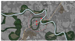
 The water system
 -
 The rural system
 -
 The perception and social activities
 -
 The general masterplan


Summary and conclusion
- 100 words approx.
Image Gallery
Please add further images/photos here
- Image Gallery
-
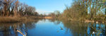
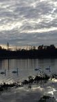
 Soltarico wetlands
 -
 Soltarico wetlands
 -
 Soltarico wetlands
 -
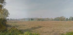
 The site: Bastia fields
 -
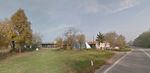 The site: One of the Bastia farms seeing from the main road
 -
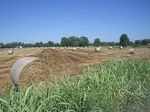
 The site: View of some Bastia fields from the main road
 -
 The site: One of the Bastia farms seeing from the main road
 -
 The site: The dead river branch in the point of the crossing with the main road (upper level)
 -
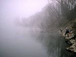
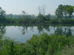 The site: the dead river branch
 -
 The site: the dead river branch
 -
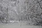
 The site: the 2014 flood
 -
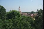 The Cavenago d'Adda town
 -
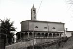 The Cavenago d'Adda town
 -
 The Cavenago d'Adda town
 -
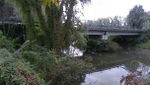
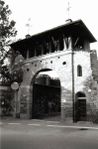
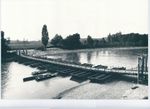
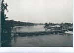 The old Adda bridge
 -
 The old Adda bridge and the view to the Bastia fields
 -
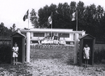 The old Adda children river camp


References
- Po river and basin authority: www.adbpo.it
- Adda River North Park: www.parcoaddanord.it
- Adda River South Park: www.parcoaddasud.it
- Lodi province: www.provincia.lodi.it
- Cavenago d'Adda Municipality: www.comune.cavenagodadda.lo.it
- Local museum about the rural traditions: www.museociocaeberloca.it
About categories: You can add more categories with this tag: "", add your categories