Collaborative Green Infrastructure Design Group F
---> back to group page working group F
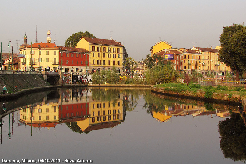
Collaborative design for implementing Green Infrastructure in the Darsena Area - Milan (Italy)
| Name | The Darsena Area | |||||||||||
| Location | Milan | |||||||||||
| Country | Italy | |||||||||||
| Authors | Maliheh Shahghadami, Maroula Shami, Elena Staffoni, Andreea Webb | |||||||||||
![[1]](/index.php?title=File:Darsena_main.jpg)
| ||||||||||||
| {{#widget:GoogleMaps | width=300 | height=200 | lat=45.452537 | lng=9.1779829 | zoom=15 | centermarker=yes | maptypecontrol=yes | overviewmapcontrol=yes | largemapcontrol=yes | scalecontrol=yes
}} | ||
Landscape and/or urban context of your case
Biogeography
Milan normally experiences a Mediterranean climate with wet and cold winters, and humid and hot summers. Metropolitan cities experience a 2-3 degree higher rise in temperature than rural areas due to the urban heat island effect. In Milan people may experience an average temperature of +4 degree Celsius to +6 degree Celsius in January, which could heat up to 15-28 degree Celsius in July. Snowfalls, a common occurence in Milan, has decreased in the last 15-20 years due to the effects of Global Warming. The average snowfall during winter could range between 30 to 40 cm. The greatest snowfall ever was recorded in January 1985 which was about 100 cm. The city’s climate which was mainly distinguished by its fog, due to the Po Basin effect has reduced considerably in the recent years due to lessened pollution and global warming. Milan is snuggled up in the lower plains of the Padana in the west-central Lombardy region of Italy. The rivers of Ticino, Po and Adda are an integral part of Milan’s province which is the first releases of the alpines. Milan occupied a total area of 181 sq.kms with a sea level rise of 122 m. The Milan city and metropolitan areas form the core industrial principal towns in Italy.
Cultural features


The Inner Circle of canals (Navigli) was a circular channel of about 6.5 km that, up to the 20's of the twentieth century, surrounded the center of Milan. The canal system was about 9 meters wide and was equipped with navigation locks and port areas of which the most famous was the Lake of Santo Stefano behind the Duomo (covered in 1857). Along the way there were 30 more little canals that were used to irrigate the orchards citizens and nurture important mills. The name of places today is recorded by the ancient urban design; The street over the Santo Stefano lake is today called Via Laghetto (Lake Street) and the street over the mills' little canal is called Via Molino delle Armi (Mills Street). The route of the canals' ring resumed the ancient moat of medieval Milan, dug in 1167, and corresponded to the current streets Fatebenefratelli, Senato, San Damiano, Visconti Modrone , Francesco Sforza , Santa Sofia , Molino delle Armi, De Amicis , Carducci , Piazza Castello and via Pontaccio. At the end of the '300 the moat, expanded and made navigable, takes the name of "Cerchia Interna dei Navigli" (Inner Circle of Navigli) and it was used for the transport of marble Candoglia to the construction of the Duomo. In 1496 the ring of canals was connected to the Martesana Canal through the basins of Incoronata and S. Marco, making it the center of the system of the canals of the Lombardy Region, allowing continuous navigation from the Adda river to the Ticino river. This important function was to decline in 1929 when the Inner Circle was entirely covered.
Cultural curiosity
- The canals were a symbol of romance that the Futurists hated. Even today in Corso Venezia number 23 you can read a license plate that says: "That's the house where in 1905 Filippo Tommaso Marinetti founded the magazine Poetry. Hence the Futurist movement launched his challenge in the moonlight mirrored in the canal".
- The Navigli and the Darsena were the subject of many paintings especially in 19th Century.
- In the middle of XV Century, Leonardo da Vinci realised a system of locks (devices for raising and lowering boats between stretches of water of different levels on river and canal waterways) for the Navigli.
Overall character
The history of Milan is closely connected with the creation of the Navigli, which pass as water network the whole city. Milan does not have a direct river connection. To ensure the water supply and to create transport routes, just in the antique ages was begun with the construction of artificial waterways, fed by the rivers of the hinterland (Ticino, Lambro, Adda). Thanks to the connection of artificial waterways from the rivers Ticino and Adda towards the Po River, Milan is practically connected to the Adriatic Sea. On the banks of the Naviglio formerly lived workers and artisans. Today, the area of the Naviglio could be a romantic area with artists' studios, original shops, romantic pubs, flea markets, and summer concerts but this atmosphere is unfortunately no more present.Outside Milan the water network serves for the irrigation of the fertile Padana fields Po Valley (the Europe’s largest plane extended from Milan to the hills). On the configuration of the locks of the channels already worked Leonardo da Vinci.

Naviglio Grande
The oldest canal was built in the years 1177-1257 and is fed by the river Ticino. The Naviglio Grande is about 50 km long, and served as an export and import route. For the transport of the enormous marble blocks from the reservoirs at Candoglia on Lake Maggiore, which were needed for the construction of the Milan Cathedral, the Naviglio was extended up to the cathedral. At the time of the construction of the cathedral, the waterway was conducted into the city center. The street name Via Laghetto (road by the pond) behind the cathedral testifies that. Today this part of the Naviglio was filled. Along the Naviglio Grande towards Ticino you will find the villages Cesano Boscone, Assago, Buccinasco, Corsico, Trezzano sul Naviglio, Gaggiano, Vermezzo und Abbiategrasso, that use the waters of the Naviglio for agriculture. Typical are the old houses and wash houses with wooden roofs and craftsman houses that that remember past times. Today they house cafes and restaurants behind the typical facades and provide an ideal atmosphere for the evening meeting for the Milan's youth.
Naviglio Pavese
Naviglio Grande and Naviglio Pavese meet in the old harbor, the Darsena. Built in the 14th century, here is the connection between Naviglio Grande and the 35 km long Naviglio Pavese, which continues to flows about Binasco and Pavia to the river Po and the Adriatic Sea. An old sluice called "Conchetta" was set in motion again at the Naviglio Pavese. The special feature of the sluice is the hydraulic mechanism that Leonardo da Vinci invented to facilitate the opening of the locks. Thanks to a simulation, the invention of Leonardo was made visible again.
Darsena - the Harbor
The port Darsena was built in 1603 as a trade hub and is the main link between the Navigli. The Naviglio Grande is flowing into the Darsena while Naviglio Pavese and Ticinello are flowing out. Along the Darsena there is a weekly market held on Saturdays, where mainly second-hand goods and antiques are offered. The boat trip on the Canal Naviglio takes about one hour. It starts on the Naviglio Grande, pass the houses of the historic Milan and arrives the old bridges in the former harbor Darsena to continue the Naviglio Pavese to the lock where, thanks to the simulation, the inventions of Leonardo da Vinci are to be admired.
Naviglio della Martesana
The Naviglio della Martesana gets its water from the river Adda, which is powered from the side arm of Lake Como, the Lago di Lecco. The Naviglio della Martesana flow through the towns of Gorgonzola and Cernusco sul Naviglio and disappears in the center of Milan Garibaldi. Along the Naviglio della Martesana leads a popular cycle route from Milan to the river Adda. There the cycle way continues to north along the river Adda to Lecco.
History and dynamics
- History of the Navigli waterways in the Regional Scale
-
![XII Century [5]](/images/thumb/6/63/640px-Navigli_XII_secolo.png/372px-640px-Navigli_XII_secolo.png) XII Century [5]
XII Century [5] -
![XIII Century [6]](/images/thumb/e/ee/640px-Navigli_XIII_secolo.png/374px-640px-Navigli_XIII_secolo.png) XIII Century [6]
XIII Century [6] -
![1457 A.D. [7]](/images/thumb/c/c9/640px-Navigli_year_1457.png/380px-640px-Navigli_year_1457.png) 1457 A.D. [7]
1457 A.D. [7] -
![XVIII Century [8]](/images/thumb/e/e6/640px-Navigli_XVIII_secolo.png/382px-640px-Navigli_XVIII_secolo.png) XVIII Century [8]
XVIII Century [8] -
![XX Century [9]](/images/thumb/4/4f/Navigli_XX_secolo.png/381px-Navigli_XX_secolo.png) XX Century [9]
XX Century [9]
![XII Century [5]](/index.php?title=File:640px-Navigli_XII_secolo.png)
![XIII Century [6]](/index.php?title=File:640px-Navigli_XIII_secolo.png)
![1457 A.D. [7]](/index.php?title=File:640px-Navigli_year_1457.png)
![XVIII Century [8]](/index.php?title=File:640px-Navigli_XVIII_secolo.png)
![XX Century [9]](/index.php?title=File:Navigli_XX_secolo.png)
The city of Milan is at the center of a territory in between the rivers Ticino and Adda, large water ways that descend from the lakes Maggiore and Como. Unlike most thriving cities, Milan is not served by a major river. The construction of the artificial canal system started off with the outlining of the Naviglio Grande in 1179, linking Lake Maggiore of the Italian Alps with the region of Lombardia and the city of Milan via the Ticino River. Eventually, this complex water system was connected to the other major Northern Italian rivers Lambro, Adda, and the Po, which ultimately feeds into the Adriatic Sea. The Naviglio Grande was ingeniously developed to maximize natural rainfall, springs, and to drain marsh and swamp lands, as well as to irrigate former wasteland. The idea was also to connect the different cities that belonged to Milan, Abbiategrasso, Turbigo, Tornavento, Vizzola and others.The Naviglio Grande is often called 'il Ticinello', or the Little Ticino, because its water is drawn from the Ticino River. It connects Lake Maggiore, from the city of Sesto Calende, to the city of Milan. The watersystem became fully navigable in 1272 after an improvement of the canal making it wider and deeper. The Naviglio Grande made the movement of important items of commerce possible: grain, alt, wine, manufactured goods, coal, timber, livestock, cheese, hay, etc. The Naviglio Grande was used for troop and defense movement as well. The granite and marble used in the construction of the Dome of Milan was transported on the Naviglio Grande from the Alps. The canal did served as an irrigation system and as a mean of transportation, and also gave the population the possibility to fish and bathe in the water. The canal contributed to an improved health of the region, vegetation and crops in the newly irrigated farmland began to grow. The costruction of Naviglio grande was followed by the Naviglio Pavese and Naviglio Martesana and these three canals were all connected through Milan via the Fossa Interna, also known as the Inner Ring. The urban section of the Naviglio Martesana was covered over in the beginning of the 1930s, together with the entire Inner Ring. Commercial carrying continued on the Naviglio Grande, but the decline was steady and by the sixties it was over for good. During the 18th and 19th C impressive villas and palaces with lush gardens were built along the canals. The elite of Milan constructed summer houses here, most of which still stand today. oday one can embark on tours of the Naviglio from Milan. The activity is intense along the Naviglio, especially on weekends. Fishing, hiking, biking, and walking are popular treats this beautiful environment offers.
- Illustrations
-
![The Darsena empty basin[10]](/images/8/84/Empty_Darsena_basin.jpg) The Darsena empty basin[10]
The Darsena empty basin[10] -
![The Darsena in the 60s[11]](/images/thumb/5/5c/Historic_Darsena.jpg/350px-Historic_Darsena.jpg) The Darsena in the 60s[11]
The Darsena in the 60s[11] -
![People on the Naviglio enjoying an Aperitivo [12]](/images/thumb/a/a3/Summer_Aperitivo.jpg/350px-Summer_Aperitivo.jpg) People on the Naviglio enjoying an Aperitivo [12]
People on the Naviglio enjoying an Aperitivo [12]
![The Darsena empty basin[10]](/index.php?title=File:Empty_Darsena_basin.jpg)
![The Darsena in the 60s[11]](/index.php?title=File:Historic_Darsena.jpg)
![People on the Naviglio enjoying an Aperitivo [12]](/index.php?title=File:Summer_Aperitivo.jpg)
Potentials and conflicts
The POTENTIALS of the site are many. The area has some potentials physical ELEMENTS that are the water basin with its dried part to be redesigned, the water canals that connect the city with the surrounding region and the Piazzas, in particular the Piazza XIV Maggio, a space with historical value that needs to be redeveloped. an other important potential is the POSITION of the site, in the middel of the city. The place is very often frequented by people, especially during the night; the inhabitants love this place. The third potential is that the place is linked to the HISTORY because the Navigli and the Darsena in the past were fundamental for the transportation of people and goods; "The marble blocks were transported from Candoglia to Milan by means of the waterways from the river Toce to Lake Maggiore, along the Ticino and the Naviglio Grande canal and then into the city as far as the darsena [dock] of S. Eustorgio. Via the system of locks, created by Veneranda Fabbrica, the marble arrived at Laghetto, now Via Laghetto, only a few hundred metres from the Cathedral construction site" [13]. See the draw above to a visual idea.
The CONFLICTS of the site are mainly identifiable in Urban conflicts:
- Too many private auto traffic, even though the area is well served by transportation and the related "wild parking".
- Lack of space due to the presence of (historic) buildings that are to preserve.
- Scarcity of green areas due to the compact fabric of the city.
- Presence of archaeological ruins (founded during some excavation; the discovery stopped the redevelopment works).
and Social conflicts:
- Social and cultural conflict between frequenters of the pubs on the Navigli (mainly responsible of the illegally parking, of the night long noise and of the dirtiness). The place have lost its original character, the little artisan atelier are today displaced by bars and pubs.
- Economic and bureaucratic problem stopped many time the redevelopment works.
What are the overall objectives of your design? What are the specific objectives for enhancing green infrastrucutre?
Please give a short written argumentation (not more than 150 words). It is ok if you have different or even contradicting objectives within your group. Just make it explicit at the beginning of your process
Analytical drawings
Please add four analytical sketches/drawings (or montages/schemes) of your case. Every group member needs to contribute at least one drawing.
- Analytical Drawings
-
analytical drawing 1
-
analytical drawing 2
-
analytical drawing 3
-
analytical drawing 4
Projective drawings
Please add four projective sketches/drawings (or montages/schemes), of course with an emphasis on green infrastructure aspects. Every group member needs to contribute at least one drawing representing his/her individual ideas.
- Projective Drawings
-
projective drawing 1
-
projective drawing 2
-
projective drawing 3
-
projective drawing 4
Design Synthesis
Please analyse the individual approaches presented so far and evaluate their strengths and weaknesses (you may use the SWOTanalysis model). Try to create a synthesis and represent it with a plan and some sketches. You can still use drawings/sketches.
- Design Synthesis Drawings
-
synthesis drawing 1
-
synthesis drawing 2
-
synthesis drawing 3
-
synthesis drawing 4
Summary of the collaborative process
Please reflect on your collaborative design process. Which potentials have you encountered? What was most difficult? What does collaborative design mean for you? (approx 150 words).
Image Gallery
You may add a series of images/photos in addition to the sketches/drawings
- Image Gallery
-
image 1
-
image 2
-
image 3
-
image 4
References
* Please make sure that you give proper references of all external resources used.
* Do not use images of which you do not hold the copyright.
* Please add internet links to other resources if necessary.
- ↑ <http://www.scattiesguardi.net/foto/alba_mi/darsena5175_800.jpg>
- ↑ <https://www.google.it/search?q=darsena+anni+60&client=ubuntu&hs=fF9&channel=fs&source=lnms&tbm=isch&sa=X&ei=Vtl4VKLJB8XwaN-MgrAF&ved=0CAgQ_AUoAQ&biw=1600&bih=722#channel=fs&tbm=isch&q=darsena+1912&facrc=_&imgdii=_&imgrc=P0lwYvNUcr3PwM%253A%3BrHWt9XSeuLLMrM%3Bhttps%253A%252F%252Ffarm7.staticflickr.com%252F6035%252F6328442023_25e6631a10_m.jpg%3Bhttps%253A%252F%252Fwww.flickr.com%252Fphotos%252Fmilan_lera_insc%252F6927394602%252Fnearby%252F%253Fby%253Downer%2526taken%253Dalltime%2526sort%253Ddistance%2526show%253Ddetail%2526page%253D2%3B1000%3B843>
- ↑ <http://www.milanoneltempo.it/darsena.html>
- ↑ Re-elaborated version of a Google Maps image, Darsena Area.
- ↑ Map of artificial channels system (Navigli) in Milan and Pavia province during XII century. In blue artificial channels built for irrigation purpose, 1989, Regione Lombardia.
- ↑ Map of artificial channels system (Navigli) in Milan and Pavia province during XII century. In blue artificial channels built for irrigation purpose, 1989, Regione Lombardia.
- ↑ Map of artificial channels system (Navigli) in Milan and Pavia province during XII century. In blue artificial channels built for irrigation purpose, 1989, Regione Lombardia.
- ↑ Map of artificial channels system (Navigli) in Milan and Pavia province during XII century. In blue artificial channels built for irrigation purpose, 1989, Regione Lombardia.
- ↑ Map of artificial channels system (Navigli) in Milan and Pavia province during XII century. In blue artificial channels built for irrigation purpose, 1989, Regione Lombardia.
- ↑ La Repubblica-Milano.it<http://milano.repubblica.it/cronaca/2013/01/23/news/la_darsena_dice_addio_all_oasi_via_libera_al_taglio_degli_alberi-51088980/>.
- ↑ Navigli live -Milano <http://www.naviglilive.it/immagini%20associazione%20naviglilive/tavole%20darsena%20parcheggio/Nuova%20cartella/darsena%20milano%20navigli%2014.jpg>.
- ↑ Corriere della sera DOVE <http://viaggi.corriere.it/viaggi/weekend/citta/2013/luglio/italia-low-cost-nightlife.shtml>.
- ↑ <http://www.duomomilano.it/en/infopage/the-candoglia-quarries/47190562-c3f4-4196-8889-729729f4e54c/>
About categories: You can add more categories with this tag: "", add your categories