Green Infrastructure 2014 Working Group M - Case Study 1
---> back to group page working group M
please add your title here
| Name | The Jordan River, نهر الأردن | |
| Country | Jordan | |
| City | West Border | |
| Authors | Esra Najjar | |

| ||
|
| ||
Rationale: Why is this case interesting?
'The Jordan River plays an important role for water resources in agriculture, industrial activity, renewable energy and domestic use in Jordan, one of the poorest countries regarding water issues, as well as in the other shared countries (Palestine, Lebanon, Syria and Israel). The scarcity of water resources with the demographic boom is considered a major challenge the country face. Nowadays, due to the lower water quality and the decreasing inflow water quantity, the Jordan River describes as an impaired water resource. Due to the constringent resource management, the river is threatened for the excessive water diversion, pollution and inappropriate development which frequently increase on account of the political situation.
'
Author's perspective
'As a student who is currently studying International Masters of landscape architecture and who is coming from one of the driest world regions with the minimum level of green cover, I am trying to highlight one of the fundamental core water issues that can be the leading point for the green infrastructure in Jordan. I am as an architect, a landscape student and a user responsible for representing such a significant case that has an influence on the social, touristic, economic urban fabrics. With the professional background and the previous experience as a local user, I am going to elucidate the current main challenges the site has via site understanding and analysis and try to enhance protect the Jordan River via connection to the green infrastructure.
Landscape and/or urban context of your case
- Biogeography, cultural features, overall character, history and dynamics
- Illustrations: maps; sketches; short descriptive analyses
- 'Physical Description
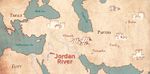
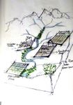
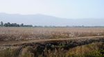
The Jordan River نهر الأردن"", 361 kilometer long river, Palestine, Israel border the river to the West, while Jordan lies to its East. The Jordan River is considered the world 'steeper' lowest river. It starts at more than 259 feet above the sea level and it ends at 286 feet below the sea level. The Hasabni 'Lebanon', the Dan 'Palestine' and the Banias 'Syria' are the three foremost streams that have formed the Jordan River. The Jordan River is divided into two parts, upper and lower. The Galilee See functions as a hinge in between the upper and lower part. Yarmouk River and the Zarqa River have shaped the lower part of the Jordan River (Jordan Lower River). '
- widths="150px"
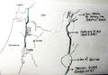
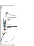
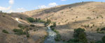
Figure 1 - Location
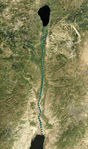
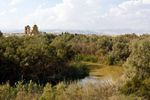
Figure 2 - Context, Landscape and the River


- 'Historical Brief/ General
The Jordan River is considered being one of the oldest world rivers. Referring to the historical studies, the river has several launched names as Sharia, which means the watering place. It has also been mentioned in the Egyptians Pharaohs records as the Jordan River. Ancient Greek Language, the word is derived from the Jordan which means down, a stream that descended quickly. The Bible mentions the Jordan River over 200 times as a defining geographical feature in the region.
The written references as books and articles have as well mentioned the influence the Jordan River has. The book 'Galilee and the Jordan, p. 169' described the river as 'Such is the Jordan, which, in its physical features, its history both sacred and civil, and in its connection with stupendous miracles, is unquestionably the most interesting and remarkable river in the world. Throughout its entire course from the Sea of Galilee to the Dead Sea, not only the river itself, but the great valley through which it runs, is far below the level of the ocean. '
- 'Historical Brief/ Biodiversity
- widths="150px"
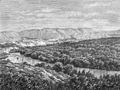
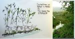
Figure 3 - Imaginary Sketch of the Former Terraces and Banks in the Jordan River

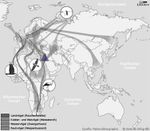
The area of the River Jordan has been known as a very rich biodiversity zone. The Map (Review Figure 4) presents the surrounding area of the Jordan River. Referring to the 'Picturesque Palestine, vol. 1, pp. 164-65' the surrounding river area has been described as the following 'Close to the river’s bank we descend fifty-five feet into a dense thicket of tamarisk, silver poplar, willows, terebinth, and many other trees strange to European eyes, with a dense and impenetrable undergrowth of reed and all sorts of aquatic brushwood. This is perforated in all directions by the runs of wild boars, which literally swarm here, while the branches are vocal with myriads of birds—nightingales, bulbuls, and especially turtle-doves—which meet here and find abundant food in the herbage of the trefoil, astragalus, and other characteristic plants of the higher plain.' The former statements function as an evidence that the river area was one of the most biodiversity zones, which reflects the importance of need to the green infrastructure policies and strategies for the zone. '
- widths="150px"
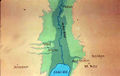
Figure 4 - The Jordan River Surroundings, Map in the Bible
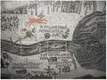
Figure 5 - The Biodiversity Surrounding, Madaba Mosiac Map


- Illustrations
Historical Context
Madaba Mosiac Context Map
- Yourimage.jpg
your visual


Analytical drawings
- Please use analytical drawing for visualising the conflicts/potentials of your site
- Analytical Drawings
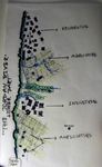
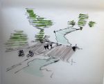
Understanding the Existing Zoning of the River Jordan Lower Part
Existed Layers

Weaknesses, Water Pollution
Potentials and Weaknesses
Birds Cycle, Crossing the Jordan River


Green Infrastructure benefits for this site
- Projective Drawings
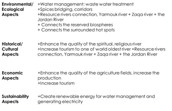
GI Benefits for the Jordan River

Potential for multifunctionality
Green infrastructure has typically multiple functions. What could be achieved for your site in this respect?
Projective drawings
- Projective Drawings
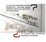
What is it about?
The Jordan River in 20 Years, Water Diversion, Pollution and Inappropriate Development
Strategy, Surrounded Rivers Network.jpg
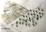
Strategy,Enhance Agricultural Fields.jpg
Strategy, Linking Hot Spots and Biospheres
Social Engagement
Minimal Change


Summary and conclusion
- 100 words approx.
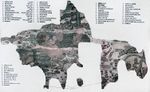
Image Gallery
Please add further images/photos here
- Image Gallery
Part of the Context
The Surrounding
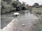
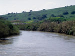
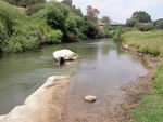
Part of the River, Nowadays
Contrast, Potentials and Weakness
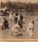
Spirituality

Jordan River Logo
Agriculture Use
View to the River


References
- please add your references here
About categories: You can add more categories with this tag: "", add your categories