Green Infrastructure 2014 Working Group J - Case Study 1
---> back to group page working group J
Schwarzwald-Germany, Negar Mehryar
| Atzenbach | name of the site | |
| Germany | country | |
| Schwarzwald, Zell im Wiesental | place | |
| Negar Mehryar | author | |

| ||
|
| ||
Rationale: Why is this case interesting?
Black Forest/Schwarzwald is the overgrown mountain region in the southern part of Baden-Württemberg, Germany and its name is derived from " the dark canopy of evergreens". Black Forest is located on eastern part of the river Rhine between Karlsruhe and Basel (Switzerland), with the length of 150 km and 60 km width.The highest pick of blackforest mountains and also the highest in Germany outside of the Alps is called Feldberg. Zell im Wiesental, is a town in the district of Lörrach, located in the extreme southern part of Black Forest very close to the Swiss border and it is situated on the river Wiese, which rises from Feldberg and it is the right branch of the Rhine. The case site is a village belongs to Zell, called Atzenbach with 3.68 km2, 447 m hight and 782 inhabitants. There is one kindergarten, one primary school and a few small stores in the village, Zell offers more supermarkets in the center. In Atzenbach the population is not increasing rather than specially young people seem to moving to bigger cities to have the benefits of job and social facilities. The economic benefit from local farmers shrinks due to global pressure on food prices. The interesting point is if no new houses or structures supposed not to get built in the area and there would be no activities on the farms, as the hills around the valley are potentially ready to get covered by trees and green infrastructure, what will happen to the valley?
Author's perspective
I am from Iran, Tehran and my Bachelor degree is in Architecture. I studied master of landscape architecture in hfwu Nürtingen-Geislingen, in IMLA program. Now I am living with a German family in the chosen place, Atzenbach where the natural beauty is breathtaking as you see the most ever-green areas in the environment or in autumn the mixture of colorful leaves spreading around gives magnificent scenes. Every day I need to travel to Lörrach to attend an intensive German course and use public transportation system which I found it so accessible and easy to get to the destination although the valley seems neglected. The appropriate bicycle roads along the river Wiese and also upon the hills are so common to use for different purposes, like hiking, biking and get to the center where the supermarkets and some other stores plus restaurants are located. But not more! For me who comes from the crowded metropolitan city, living in this valley is obviously a huge contrast also interesting and at the same time boring. what is your professional/educational background and your relation to the site?
Landscape and/or urban context of your case
Natural features
The entire municipality Zell's is part of the southern Black Forest . In addition, the cell still has interest in two Fauna-Flora-Habitat (FFH) territories: 111.87 acres of the district are part of the conservation area "Weidfelder in the upper meadow valley". For the Black Forest typical cultural landscape of Weidfeldern, beech woods and meadow brooks has a total area of more than 1,700 acres and provides inter alia habitat for bullhead , brook lamprey , Green Fork Teeth moss , Spanish flag and greater mouse-eared . 3.53 hectares of the district are also to FFH "Röttler forest". It is a distributed via multiple communities, more than 2,500 acres of structurally rich woods and fields with Buchenaltbeständen . The fact native species include the yellow-bellied toad , the stag beetle , the helmet-Azurjungfer , the Green Fork Teeth moss , the Bechstein - and the Geoffroy's bat and the greater mouse-eared .A small district piece of 1.71 acres is also part of the SPA " Southern Black Forest "(total 33,515.91 hectares), whose inventory of species including the owl , peregrine falcon , Black Kite , Honey Buzzard and the Zitronengirlitz belong. Also close to Zeller district seven natural monuments. It is the hilltop of "Rümmelesbühl" at Gresgen that Atzenbacher waterfalls Höllwasserfälle Pfaff mountain, the Fischbach waterfalls in cell and three trees: A standalone pasture Linde in "Moosrain" Pfaff mountain, the spruce "Lonely fir "near the High Möhr and a Weidbuche in "Erlenboden" at Gresgen. Atzenbach lies to the east of the Zeller urban area and how the districts cell and Mambach, in the valley of the field and not in the surrounding mountains. It is bordered to the south and west by the cell, on the southeast by Riedichen, on the north by Mambach and to the northwest by Pfaff mountain. In the east, the area borders on the community Häg-Ehrsberg in whose territory the district Atzenbachs a 25-acre forest enclave at Kupferbühl has
History
Presumably, the origin of the name Atzenbach comes from a single farm. Probably the village was later named after this court. This farm probably belonged to an owner name "Atzo". So Atzo or in the stream. With Bach today's meadow meant. In 1113 Walcho handed of Waldeck almost his entire estate to the monastery of St. Blaise . This included goods in Atzenbach. This is the first mention of the village. In the 14th century Atzenbach came through exchange and purchase the convent Säckingen . Until 1805 Atzenbach belonged to the stiftsäckingischen Bailiwick cell . Thus Atzenbach included over 450 years in Austria . By the Treaty of Pressburg in 1805 the village was awarded the Grand Duchy of Baden, which ended in 1918 with the abdication of the regent. After the state of Baden in the 50s merged with Württemberg, Atzenbach one of Baden-Württemberg . Atzenbach was originally a farming village. Typical of Atzenbach was also present in the whole southern Black Forest farmhouses, thermoformed hip roofs . Today these old hipped roofs are only 2 left. By January 2, 1848, changed the face of the village. At that time, the first spindles spinning Atzenbach began to turn. Through the new jobs created in the rising industry a strong immigration to Atzenbach arose. Thus, changing the face of farming village to village workers. The textile industry, which was in the 1970s to the end, took the village of wealth and prestige. In 1975 Atzenbach was a district of Zell im Wiesental. The district is located northeast of the cell. The Todtnauerli , also known as Upper Wiesentalbahn, was a private narrow gauge railway that ran from Zell im Wiesental about Atzenbach and Schönau Todtnau. It was opened in 1889 and closed in 1967
Culture/Events
Zeller Carnival, is the largest festival in Zell im Wiesental.on 11th of November the audience in the inn rooms or in the town hall will entertain foolish. The participating "old wives" are usually dressed young men who master an obstacle course. Zeller Freilichtspiele, Since 1996, the Zeller costume group organizes Zeller outdoor games , which are held every few years.
Clubs in Atzenbach: Friends of elementary school Atzenbach, Kaninchenzuchtverein Atzenbach, Catholic church choir Atzenbach, Men's Choir "friendship" Atzenbach, Narrenzunft Atzenbach, Musikverein Atzenbach, Music is our life, from the original brass music on concert orchestra music, from rock music to church music ranges all our musical repertoire. Music connects - play with friends bands is always a special experience where the socializing is never too short. We are a pretty young team, but music and like to celebrate with our "old hands". With us not only the musical ability but also the fun and joy of life at the club in the foreground
Biogeography, cultural features, overall character, history and dynamics
- Illustrations: maps; sketches; short descriptive analyses
- Illustrations
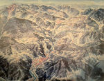
Oberes Wiesental overview
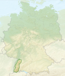
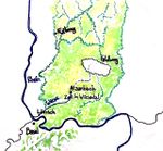
Map of Black Forest-Germany
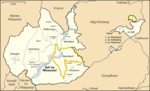
Map of Zell im Wiesental,Atzenbach


Analytical drawings
- Please use analytical drawing for visualising the conflicts/potentials of your site
- Analytical Drawings
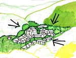
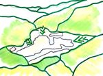
Anlytical map
your drawing
your drawing
your drawing


Green Infrastructure benefits for this site
Since the site has strong ecosystem features, improving anthropocentric functions and activities such as increasing social life quality in Atzenbach, as the benefits of Green Infrastructure could make the region more atractive for local. The closest super market there is 2Km away from the whole site, so local people to provide daily needs have to use cars more often. In addition a public place , park or square, can Enhance recreational purposes and social activities. Look again at the multiple benefits of green infrastructure - what could be achieved in your site and which are most relevant?
Potential for multifunctionality
By enhancing social life quality and human-based activities in the area, and providing daily services for local, the need to travel to biger regions or towns would decrease and as the area is naturally and from the aesthetic and ecological aspects, such as climatic adoptation, open spaces and water management well organized, people would rather stay and enjoy the peacefull life there. Green infrastructure has typically multiple functions. What could be achieved for your site in this respect?
Projective drawings
- How would you like this case to change in the near future? (in 1-2 years)
- providing social services including super market, library and bookstore, also recreational public places such as public park or square in this region.
you may add a short explanation here
- And how could it look like in 10-15 years?
- Atzenbach would turn to a center for social and cultural activities and events.
you may add a short explanation here
- Projective Drawings
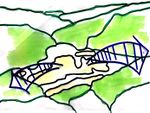
- Yourdrawing.jpg
projective drawing
- Yourdrawing.jpg
projective drawing
- Yourdrawing.jpg
projective drawing
- Yourdrawing.jpg
projective drawing
Summary and conclusion
- 100 words approx.
Image Gallery
Please add further images/photos here
- Image Gallery
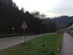
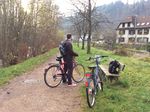
Street and bicycle road along Wiese River-Atzenbach
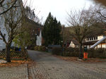
Residential area-Atzenbach
Residential area-Atzenbach
Residential area-Atzenbach
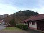
Residential area-Atzenbach
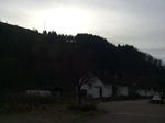
From Atzenbach to Zell
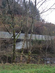
Wiese River between autobahn and bicycle road-Zell
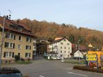
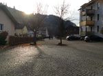
Zell im Wiesental


References
- http://www.zell-im-wiesental.de/index.php?id=117, http://de.wikipedia.org/wiki/Atzenbach, http://www.MyGermanCity.com, http://www.musikvereinatzenbach.de/index.php/ueber-uns, http://brandedinthe80s.com/tag/thundercats
please add your references here
About categories: You can add more categories with this tag: "", add your categories