Green Infrastructure 2014 Group H - Case Study 2
---> back to group page working group H
please add your title here
| Name | AlAzhar park and surrounding neighborhood | |||||||||||
| Country | Egypt | |||||||||||
| City | Cairo | |||||||||||
| Authors | Abdullah Arafa | |||||||||||

| ||||||||||||
| {{#widget:GoogleMaps | width=300 | height=240 | lat=30.0409685 | lng=31.265254099999993 | zoom=15 | centermarker=yes | maptypecontrol=yes | overviewmapcontrol=yes | largemapcontrol=yes | scalecontrol=yes
}} | ||
Rationale: Why is this case interesting?
AlAzhar park is considered to be the green lung inside a very dense and crowded Metropolitan area of Cairo city, it was built on an old landfill site and designed to be a very attractive monument of the capital.
The most interesting thing about this park that its completely surrounded by grey infrastructure from all directions with no green connectivity whatsoever to any existing park or even natural area, even the near castle or the ElMokattam Hill situated inside Cairo city, which makes it an ideal starting point of establishing a green infrastructure in the surrounding of the park to the city borders. In addition to the fact that this park has a very high number of plant species and water features (though most are artificial) rendering it to be an ecological center of the city and the heart of the first steps of a green infrastructure that can be constructed through the city.
Author's perspective
I am a student in landscape architecture in master degree with a B.Sc and M.Sc in horticulture and garden design, dealing with plants, people and land was my profession for more than seven years and I consider AlAzhar park to be one of the most interesting cases for me concerning landscape architecture and green infrastructure.
The park was built to serve as a monofunction recreation area for the people of Cairo city, with the abundance of open space and activities through the park. It's always very crowded due to the fact that very few public parks still exist in Cairo city and that people escape from grey dull grey infrastructure to this kind of green open space to spend their free time and socialize in such places, in addition to experiencing the fabulous view of the high ground of this park that overlooks the whole city of Cairo and the old historical Islamic monuments situated beside the park.
In my point of view, we can transfer the park from a monofunction structure to a multifunction entity that serves green infrastructure purposes, the existence of all landscape elements in this park makes it an ideal location for these goals, wide variety of plant species, different landuse patterns, high topographic fluctuations, different water features and high density of human contact are all elements that can be promoted for a multifunction landscape serving green infrastructure purposes in a city that does not have any kind of green infrastructure implemented in it's planning and perhaps one day this could be the heart of spreading green infrastructure through the whole city, and thus solving a lot of Cairo's environmental issues of pollution mainly and of coarse all other landscape aspects.
Landscape and/or urban context of your case
INTRODUCTION
The origins of Al-Azhar Park project date to 1984, when the Aga Khan Award for Architecture organised a conference on the subject of The Expanding Metropolis: Coping with the Urban Growth of Cairo. At that time, the city was confronted by the array of contemporary development challenges faced by many cities, not least population pressures, a decline in the quality of housing and the attendant problems these conditions create. Despite these challenges, the question of how to reconcile conservation and development was a fairly new one. It was clear that Cairo needed more green space. One study found that the amount of green space per inhabitant was roughly equivalent to the size of a footprint. It is one of the lowest proportions in the world. It was on the occasion of the conference that His Highness the Aga Khan announced his decision to finance the creation of a park for the citizens of the Egyptian capital. The only central location which was of suitable scale and which lent itself to rehabilitation was the derelict Darassa site, a 30- hectare (74 acre), 500-year-old mound of rubble in the inner city, between the eastern edge of the 12th Century Ayyubid city and the 15th Century Mamluk “City of the Dead”. While the neighbouring district of Darb al-Ahmar was poor, it featured one of the richest concentrations of Islamic art and architecture in the world. The challenge was to revitalise this heritage in ways that turned traditional notions about cultural monuments on their head - that rather than being a drain on resources, they could be a stimulus for social and economic development. The Park project was therefore intended to be a case study for a variety of development challenges, ranging from environmental rehabilitation to cultural restoration. The objective was to create models of development that could be replicated in many other settings, and in particular in the historic cities of the Islamic world. Almost one-third of historic cities on UNESCO’s list of world heritage sites are in the Islamic World. Many face pressures similar to those of Cairo.
HISTORY
When the city of Cairo was rebuilt and laid out by the Fatimids in 969–974 (358–363 Hijri), and named al-Quahira (“the victorious”), 20 percent of it – roughly 30 hectares – was devoted to open space. East of the al-Mu’izz palace, horse-riding grounds were turned into a royal park and garden and a large central space to the west was dedicated to military parades and religious gatherings. A dozen years later, al-Azhar (“the Radiant”) mosque and theological college were built (989). During the Fatimid, Ayyubid and Mamluk periods, Cairo was one of the most advanced cities of learning in the Islamic world. Many landmark buildings around the Park, including the Citadel, testify to the glory of mediaeval Cairo. In the first half of the twentieth century, Cairo was still a city of villas and gardens. In the last 50 years, however, population pressures and high-rise construction built to meet the consequent demand have made it one of the largest and most complex cities in the world. Its population has tripled since 1952, and today greater Cairo has around 17 million people. The growth was compounded by an urban dynamic characterised by disinvestment in the city centre areas. The combination of less investment – particularly in the maintenance and development of housing – and an influx of people, created stresses in the urban fabric that condemned many people to lower standards of living. It was widely assumed that the resulting downward spiral, ending in urban slums, was inevitable. The Aga Khan Trust for Culture set out to prove that those conditions could be reversed and that positive change could be sustained.
FROM A WASTELAND INTO A PARK
When the project of turning a rubble dump into a park that would act as a catalyst for development was first mentioned 20 years ago, it was considered outlandish. At that time, the concept of environmental improvement in cities was limited to planting trees in a few streets. Since then, many cities, notably Barcelona, have transformed neglected areas into vibrant city centres, but in the early 1980s, the concept was still new and untested. Despite scepticism, the local authorities approved the choice of the site and the first plans were drawn up. The work was delayed by the integration into the Park site of three large fresh water reservoirs, each 80 metres in diameter and 14 metres deep. But in 1990 a protocol was signed between the Aga Khan Trust for Culture and the Governorate of Cairo that led to new plans taking into account the water tanks. In 1992, the Aga Khan Trust for Culture established its Historic Cities Support Programme, to implement urban rehabilitation projects in different parts of the Islamic world. Cairo became its most demanding project, encompassing not only the construction of the Park but the restoration of the 1.5 kilometre section of the Ayyubid wall revealed by the removal of the accumulated rubble. It also included the socioeconomic rehabilitation of the neighbouring Historic City, which required launching of numerous restoration and community-initiated development projects. The larger area development project became a testing ground, and a case study, for finding solutions to challenges ranging from the technical demands of physical restoration to the equally challenging issues of socioeconomic development.
ARCHITECTURE
The three buildings (Citadel View Restaurant, Lakeside Café and entrance building) were the object of a competition between seven international and Egyptian architectural firms. The Citadel View Restaurant was designed by Egyptian architects Rami el-Dahan and Soheir Farid. The Lakeside Café project was awarded to Serge Santelli, Paris. The total surface of the entrance building is 860 m2, and the Citadel View Restaurant site is 3965 m2, including the external terraces. The Lakeside Café has over 1500 m2 usable surface. All buildings have masonry bearing walls with a high-sand-content limestone cladding, marble and stone pavements, and marble and ceramic tiles. All the Park buildings rest on piles or rafts. Nearly all materials used are of Egyptian origin, as is all the furniture, mostly made by local carpenters in Darb al-Ahmar.
LANDSCAPE FEATURES
The Park’s site was designed by Sites International, an Egyptian landscape architectural firm. Most features of the Park were based on the traditional use of public spaces in Islamic contexts. This legacy can be seen in a variety of styles from different periods and different regions. It is reflected in the bustan-like orchard spaces, the shaded sitting areas (takhtaboush) and the Fatimid archways used in the construction of Park buildings, among other elements. Persian and Timurid elements are also reflected in the water channels and fountains. Specific features of the Park include:
· The Royal Palm Promenade
· Geometric Garden
· Southern lookout
· Children’s play area
· Children’s amphitheatre and stage
· Northern lookout plaza and kiosk
· Water cascade garden
· Lake
· Orchard
· Playing fields
· Historical wall promenade and amphitheatre
The fountain and stream-lake are divided into two systems. The cascade and fountain system, which is approximately 90 metres long, is run by two pumps that re-circulate the water. The stream and lake are fed directly by raw Nile water from a nearby municipal line, a pipe measuring approximately 170 metres off site. The lake water is then filtered mechanically and pumped throughout the Park’s irrigation main line. The total length of the main and lateral irrigation lines within the Park site measures approximately 10 kilometres. The Park has all necessary amenities, such as ramps and toilet facilities, for the handicapped. The marble benches and lighting were designed by Sites International and built by local artisans using local materials.
HORTICULTURE
The realities of seasonal high temperatures, low humidity, scant rainfall and desert winds imposed severe conditions on the Park’s plants and trees. Specialist plant nurseries were created, both on site and outside Cairo, to identify the best plants and trees for the soil, terrain and climate. The nurseries also carried out the propagation of the necessary plants to furnish the Park – 89 varieties of trees, 51 shrubs, five sorts of grass, 14 climbers, 50 groundcover plants and 26 varieties of succulents. Over 655,000 young plants from cuttings and seed were planted. Most of the lawn was planted elsewhere and brought in as turf. The lawn areas required four metric tonnes of grass seed. The nurseries contain over two million plants and trees, which can be used not only for replenishing the Park’s vegetation, but for planting in pots in the courtyards and roof terraces of the historic city, for sale to official and private garden contractors and for visitors to the Park. A sales outlet for plants is envisioned on site.
Perhaps the most interesting local varieties of trees are Sycamores, Zyziphus and four types of Acacia. Other species include the Cassia smallii and Sophoras arizonica and japonica trees. The non-Egyptian native plants were developed from stock in the country and adapted to local conditions. A good deal of experimentation was required to find hybrids that would withstand the difficult soil conditions found at the Park. Reflecting garden traditions in both the East and West, many medicinal and culinary herbs were planted in the Park, including laurel, chamomile, mint, lemon grass, coriander and thyme. A wide variety of roses have been grafted onto Rosa canina rootstock to ensure that they will thrive in Park conditions. The Park utilises an irrigation system providing water through drippers and sprinklers. The irrigation is regulated by a special weather station in the Park which calculates the water needs based on temperature, humidity and wind speed.
- Illustrations
-
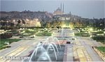 Historical city view
 -
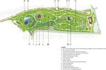 Park map
 -
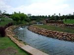 artificial river


Analytical drawings
- Please use analytical drawing for visualising the conflicts/potentials of your site
- Analytical Drawings
-
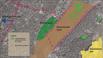
 Park analysis
 -
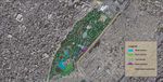
 Surrounding neighborhood analysis
 -
your drawing
-
your drawing


Green Infrastructure benefits for this site
- Having a kind of an artificial river and lake is very effective for connecting water from this site to the Nile river situated in the western side of the park, in addition to having the old historical Adequate that was supposed to connect water from the old historical cairo to the Nile river, this connection could be more of an ecological connection and thus having marine river life through the city.
- The abundance of tree species is a good factor for the beginning of establishing a green infrastructure entity that we could develop nodes and corridors of green connections starting from the park and ending somewhere in the borders of the city, this will promote bird life and will enhance birds mobility through the city, in addition to more species like insects or so may thrive under these variety of plant species. Thus achieving more environmental balance and more natural control of invasive species that harm Egyptian community.
- Eventually increasing green space will lead to better ecological conditions like less pollution, less carbon dioxide rates, more clean air ... etc. of.
- The impact on social life will be dramatic too; the stress on citizens will decrease significantly first because of more relaxing green space that can be offered with connections to important hot spots through the city, that people may start to choose these green routes instead of their regular routes to their daily activities, resulting in an overall improvement in the productivity and welfare of Cairo residents.
- Sustainability is a great issue in Cairo, by increasing the green infrastructure to grey infrastructure ratio; people will start to have social awareness of sustainability and the need of proper use of resources, water management programs could then be implemented in our system and the life style of the citizens could be altered from intensive building and vertical development to more sustainable environmental friendly development that will benefit future generations.
Potential for multifunctionality
Green infrastructure has typically multiple functions. What could be achieved for your site in this respect?
Projective drawings
- How would you like this case to change in the near future? (in 1-2 years)
- you may add a short explanation here
- And how could it look like in 10-15 years?
- you may add a short explanation here
- Projective Drawings
-
projective drawing
-
projective drawing
-
projective drawing
-
projective drawing
Summary and conclusion
- 100 words approx.
Image Gallery
Please add further images/photos here
- Image Gallery
-
your image text
-
your image text
-
your image text
-
your image text
-
your image text
-
your image text
-
your image text
-
your image text
References
- please add your references here
About categories: You can add more categories with this tag: "", add your categories