Green Infrastructure 2014 Working Group D - Case Study 1
---> back to group page working group D
Green infrastructure potential in the 14th arrondissement of Paris
| Name | 14th arrondissement of Paris | |
| Country | France | |
| City | Paris | |
| Authors | Teodora Koos-Morar | |

| ||
|
| ||
Rationale: Why is this case interesting?
Please explain in short why this site has green infrastructure potential and what makes it special (150 words approx)
Author's perspective
I have a diploma in Landscape engineering from the Faculty of Horticulture at the University of Agricultural Sciences and Veterinary Medicine of Cluj-Napoca, Romania. In 2012 I moved to Paris for an international Master in Management of Eco-Innovation. After university I worked as a Consultant in sustainable development and environmental communication. At the moment I am founding member and responsible of communication & landscape innovation at the newly established Institute of Innovation for Transition to Sustainability in Paris. In summary I am a Landscape engineer specialised in sustainable development. Living in Paris I feel that the amount of green spaces is very low and not in proximity to where people live. I would like to see Paris greener, and this is why I chose to start with one of my favourite neighbourhoods, the 14th arrondissement. I used to live in the Cité Internationale Universitaire campus and I often go for picnics, walks or jogging in Parc Montsouris. My vision is a connected green infrastructure, first at the level of this administrative district and maybe after scale it up at the level of the city.
Landscape and/or urban context of your case
Paris urban context
- Geography: Paris is located in northern-central France. Excluding the outlying parks of Bois de Boulogne and Bois de Vincennes, Paris has an area of about 87 km2 (8700 ha), enclosed by the 35 km ring road, the Boulevard Périphérique. In 1860 the city created the twenty clockwise-spiralling arrondissements (municipal boroughs). In 1929, the Bois de Boulogne and Bois de Vincennes forest parks were officially annexed to the city, bringing its area to about 105 km2 (10 500 ha).
- Climate: Paris has a typical Western European oceanic climate which is affected by the North Atlantic Current. Situated midway between an oceanic climate to the west and a semi-continental climate to the east, Paris’ climate throughout the year is mild and moderately wet with mild winters and relatively clement summers. Average annual precipitation is 652 mm with light rainfall fairly distributed throughout the year.
- Green areas: Paris has more than 421 municipal parks and gardens, covering around 3000 ha with more than 250,000 trees. Between 1853 and 1870, Napoleon III and the city's first director of parks and gardens, Jean-Charles Alphand, created the Bois de Boulogne forest park (W), the Bois de Vincennes forest park (SE), Parc Montsouris(S) and the Parc des Buttes-Chaumont (NE), located at the four points of the compass around the city.
- Transport: There is a good mix of public transportation in Paris, including metro, RER, buses and tramways. Cycling takes a large portion of the urban public transport with 440 km of cycle paths and routes. The bike sharing system of Paris, Velib has more than 20,000 public bicycles distributed at 1,800 parking stations.
- Water and sanitation: In its early history, Paris had only the Seine and Bièvre rivers for water. From 1809, the canal de l'Ourcq provided Paris with water from less-polluted rivers to the north-east of the capital.From 1857, the civil engineer Eugène Belgrand, under Napoleon III, oversaw the construction of a series of new aqueducts that brought water from locations all around the city to several reservoirs built atop the Capital's highest points of elevation. From then on, the new reservoir system became Paris's principal source of drinking water, and the remains of the old system, pumped into lower levels of the same reservoirs, were from then on used for the cleaning of Paris's streets. This system is still a major part of Paris's modern water-supply network.
Characteristics of the 14th arrondissement of Paris
- The 14th arrondissement of Paris is located on the left bank of the River Seine and its total land area is 5.62 km² (562.1 ha).
- The arrondissement has a high density population with 141 664 inhabitants (INSEE, 2011).
- Modern day district includes the following neighbourhoods: Quartier Montparnasse, Quartier du Parc Montsouris, Quartier du Petit Montrouge and Quartier de Plaisance. The Montparnasse district is best known for its 210 m tall skyscraper, the Montparnasse tower (Tour Montparnasse) which used to be France's tallest building until 2011. Gare Montparnasse, a major railway terminus, is located close to the tower.
- Open spaces: The most important open spaces in the 14th arrondissement are: the Montparnasse cemetery, the Parc Montsouris and Cité Internationale Universitaire de Paris. Furthermore, the grass lined tramway running on Boulevard Jourdan, Boulevard Brune and Boulevards des Maréchaux separates Parc Monsouris and Cité Universitaire.
- Architecture: Modern Paris busiest streets, avenues and boulevards today are a result of its late 19th century city renovation by the Baron Haussmann. The 14th arrondissement was re-designed by opening large avenues bordered with trees, a sophisticated network of underground sewers, vast water reservoirs and public gardens.
- In the 1970 the district became the place of experiment for contemporary urbanization. The controversy appeared with the redevelopment of Montparnasse train station and its ‘ugly’ tower, the unusual Place de Catalogne-Séoul or the opening of a vast park known as Coulée Verte along Rue Vercingétorix.
- Culture: The 14th district has traditionally been home to many artists. During the interwar period Montparnasse became the centre of artistic life and the French New Wave (Nouvelle Vague). Today 14th is fully dedicated to the small industry and crafts and has retained its bohemian atmosphere as it hosts many artist studios with huge glass windows or residences and the international Cité Universitaire. 14th is the residential extension of the Latin Quarter, hosting ex-students, and also young ones mainly due to Cité Universitaire.
- Illustrations
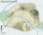
Elevation map of Paris' valleys and highest buttes (altitude in metric and imperial); also included: Paris' existing and defunct rivers and major and minor waterways. (http://en.wikipedia.org/wiki/User:ThePromenader#mediaviewer/File:Jms_paris_elevation_map_2012.jpg)
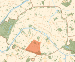
Green areas in Paris and the 14th arrondissement. (http://en.wikipedia.org/wiki/14th_arrondissement_of_Paris#mediaviewer/File:Paris_14e_arr_jms.gif)
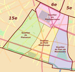
Neighborhoods within the 14th arrondissement. (http://www.travelfranceonline.com/paris-14th-district-14eme-arrondissement/ )
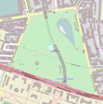
Map of Parc Montsouris. (http://en.wikipedia.org/wiki/Parc_Montsouris)


Analytical drawings
- Please use analytical drawing for visualising the conflicts/potentials of your site
- Analytical Drawings
- Your drawing.jpg
title
- Your drawing.jpg
your drawing
- Your drawing.jpg
your drawing
- Your drawing.jpg
your drawing
Green Infrastructure benefits for this site
Look again at the multiple benefits of green infrastructure - what could be achieved in your site and which are most relevant?
Potential for multifunctionality
Green infrastructure has typically multiple functions. What could be achieved for your site in this respect?
Projective drawings
- How would you like this case to change in the near future? (in 1-2 years)
- you may add a short explanation here
- And how could it look like in 10-15 years?
- you may add a short explanation here
- Projective Drawings
- Yourdrawing.jpg
projective drawing
- Yourdrawing.jpg
projective drawing
- Yourdrawing.jpg
projective drawing
- Yourdrawing.jpg
projective drawing
Summary and conclusion
- 100 words approx.
Image Gallery
Please add further images/photos here
- Image Gallery
- Yourimage.jpg
your image text
- Yourimage.jpg
your image text
- Yourimage.jpg
your image text
- Yourimage.jpg
your image text
- Yourimage.jpg
your image text
- Yourimage.jpg
your image text
- Yourimage.jpg
your image text
- Yourimage.jpg
your image text
References
- INSEE, 2011: http://www.insee.fr/fr/ppp/bases-de-donnees/recensement/populations-legales/departement.asp?dep=75
- 14th arrondissement of Paris - Wikipedia: http://en.wikipedia.org/wiki/14th_arrondissement_of_Paris
- Paris - Wikipedia: http://en.wikipedia.org/wiki/Paris
- Travel France Online: http://www.travelfranceonline.com/paris-14th-district-14eme-arrondissement/
- Parc Montsouris - Wikipedia: http://en.wikipedia.org/wiki/Parc_Montsouris
- Air Quality in Europe: http://www.airqualitynow.eu/city_info/paris/page2.php
About categories: You can add more categories with this tag: "", add your categories