File:Mirijevo study site.png
No higher resolution available.
Mirijevo_study_site.png (384 × 303 pixels, file size: 219 KB, MIME type: image/png)
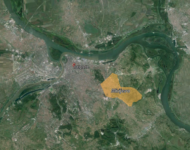
This map is representing position of the study site in relation to Belgrade. Mirijevo is located around 7 km from city center on the eastern outskirts of Belgrade's urban zone. The neighborhood is developed in the valley of Mirijevski potok (creek which is a right tributary to the Danube). Terrain has valley shape, with highest contour of 200 m above see level. Lowest contour is at 100 m above see level, where the Mirijevo stream is situated. West-facing slopes and east-facing slopes are predominant.
File history
Click on a date/time to view the file as it appeared at that time.
| Date/Time | Thumbnail | Dimensions | User | Comment | |
|---|---|---|---|---|---|
| current | 16:04, 28 November 2014 | | 384 × 303 (219 KB) | Stefanoficm (talk | contribs) | This map is representing position of the study site in relation to Belgrade. Mirijevo is located around 7 km from city center on the eastern outskirts of Belgrade's urban zone. The neighborhood is developed in the valley of Mirijevski potok (creek whic... |
You cannot overwrite this file.
File usage
The following page uses this file: