River Liesing, Vienna
Restructuring and renaturalisation of a former 70ies "Concrete bed river" in the City of Vienna according to the European water directive
| Name | Liesing River | |
| Place | Vienna | |
| Country | Austria | |
| Topic | Restructuring and renaturalisation of a former 70ies "Concrete bed river" in the City of Vienna according to the European water directive | |
| Author(s) | Barbara Birli | |
| Completion | 2005 | |
| Client | City of Vienna | |
| Project costs | about 50 Millionen Euro | |

| ||
| <googlemap version="0.9" lat="48.204998" lon="16.246719" type="satellite" zoom="11" width="300" height="250">
</googlemap> | ||
Rationale: Why is this case study interesting?
The river liesing project is not only a project about the revitalisation and about improving the habitats of a small river in a European capital, it is also a good example of how to fund such a big construction. It is a project with various landscape architecture offices involved and public participation played an important role, it was co-funded by the European Union. The river Liesing project includes various aspects of the profession landscape architecture, it is regarded as a sucessful project, although it is a pity that not the whole river within Vienna was subject to revitalisation, but only a certain part, where the reconstruction of the canal system below the river bed was necessary.
Author's perspective
I choose this example personally because I know the area very well, I liked it when I was a child myself and I like to go there today with my family. My approach is also to present a sucessful project which involves so many parts of the broad spectrum of landscape architecture specialist knowledge - from water managamenent, over design of the area around the river to project management including EU funding and public participation to actually politics - making such a big project happen at all.
Landscape and/or urban context
- Biogeography, cultural features, overall character, history and dynamics
Illustration: Map; sketches; short descriptive analyses
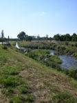
The river Liesing is located in the South of Vienna. It has two souces, the “Dürre Liesing” and the “Reiche Liesing”. While the Dürre Liesing arises from a limestone area, the Reiche Liesing arisies from the flysch limbestone area of the Wienerwald, which makes the river grow rapidly in case of heavy rainfall, this lead despite the strict regulation in a concrete river bed to the river bursting its banks. In Vienna river Lising has shaped the landscape through meanders, deposition of sediments and erosion earlier, but after a havy regulation in the 50ies followed by an even stricter regulation in the 70ies it was forced in the staight river bed, which lead to a low biodiversity and to the river running quickly. After housing development in the areas around the river, mainly in the 90ies, first attempts to rearrange the surrounding and to adapt it to the new user needs were started, after two major fluds in the 90ies, and the implementation of the European Water Directive the City of Vienna decided for the revitalisation of a 5,5 km area of the river to be completely renewed and revitalised.
Cultural/social/political context I European Water Directive
The Policy background of this project is the implementation of the European Water Directive 1 The purpose of this Directive is to establish a framework for the protection of inland surface waters, transitional waters, coastal waters and groundwater which:
(a) prevents further deterioration and protects and enhances the status of aquatic ecosystems and, with regard to their water needs, terrestrial ecosystems and wetlands directly depending on the aquatic ecosystems; (b) promotes sustainable water use based on a long-term protection of available water resources; (c) aims at enhanced protection and improvement of the aquatic environment, inter alia, through specific measures for the progressive reduction of discharges, emissions and losses of priority substances and the cessation or phasing-out of discharges, emissions and losses of the priority hazardous substances; (d) ensures the progressive reduction of pollution of groundwater and prevents its further pollution, and (e) contributes to mitigating the effects of floods and droughts
Government bodies of the EC member states are requested to implement the directive into national law and to identify river basin districts and responsible authorities (Art. 23, Art. 3) until 2003. The basic units of the directive have to be defined until end of 2004 (Art. 5). A monitoring network has to be established and accompanied by public relations work until 2006. In 2008 draft river management plans have to be in a form to be presented to the public. For 2009, the finalised river management plans should include milestones and an implementation plan to achieve the specific objectives (Art. 13, Art 11). Following this timetable it is expected that member states of the European Union will meet the environmental objectives in 2015. ____
Cultural/social/political context II LIFE-Environment
The specific objective of LIFE-Environment is to contribute to the development of innovative techniques and methods by co-financing projects. 4 areas are eligible for funding through the European Union: • land-use development and planning; • water management; • reduction of the environmental impact of economic activities; • waste management; • reduction of the environmental impact of products through an integrated product policy. LIFE is divided into LIFE-Nature, LIFE-Environment and LIFE-Third Countries. 47% of the total budget of the LIFE programme (€ 640 million) is spent for LIFE-environment.
The successful proposal for co-funding by the LIFE programme was an important basis for the project.
History
The aim of the project was to improve the situation at the river Liesing according to the EU Water Directive in order to archive “maximum ecological potential” of a heavily modified water body.
The specific aims of the projects were:

- Improvement of the water quality to quality class II according to the saprobic system.
- Re-introduction of a diverse macrozoobenthos and river-specific fish species into the relevant river section.
- Establishment of a string of aquatic ecosystems with restored ecosystem function and structure which may function as aquatic ecological corridor extending far into the urban area.
- Creation of new habitats for priority species (council directive 92/43/EEC on the conservation of natural habitats and of wild fauna and flora).
- International exchange of project results.
After valuation of the actual state, a project structure has been developed by the landscape architecture office Knoll and the City of Vienna, Departments 30 and 45.
The area has been divided into 4 sections, the following landscape architecture offices in Vienna were comissioned to design the areas according to the master plan by office Knoll
Spatial analysis of area/project/plan
- What are the main structural features?
- How has it been shaped? Were there any critical decisions?
Illustration: Map/diagram/sketches photos and background notes
The project started with the need of the canal system which run below the river bed to be renewed. It was clear, that this needed major financial input from the city of Vienna and it was decided to build a new wastewater treatment plant in the area next to river liesing. It was then decided to apply for additional funding from the EU in order to provide the necessary funding for an appealing and natural design of the river banks and the area close to the river. The application to the LIFE programm was sucessful.

After an ecological assessment of the actual sitution the area was divided into 4 project areas which were renewed one after the other.

Copyright of pictures.www.life-liesingbach.at/web site closed after project end
Core Questions Working Group Nature Conservation / Water
What is the role of user groups?
There are various user groups. After the reconstruction a survey was done among users, distinguishing in between the users living nearby, the persons working nearby and other users coming to the site. At two separate places on the project site useres were asked for an interview. Interviews were done also with those persons that were involved in the participation process that accompanied the project. 44% of the users stated to be on the site more often than before the reconstruction. Most users agreed on the necessity of nature protection and that this project was successful in reaching this, although users asked for an interview at the site were less concerned with topics such as nature conservation and flood protection than those involved in the participation process. A majority of users asked for a revitalisation of the whole river in Vienna.
Although improving the situation for user groups was not the actual reason for the project (but the technical necessity of renewing the canal system below the river) with the sucessful application to the LIFE project an improvement for users and public participation was possible as a "side effect" of renaturalisation.
What is the role of the city?
The project is on city space. So the city has the role of narroving down the space available for the water and the banks. As in this project high water situations had to be considered and these are often solved nowadays by giving the river the necessary space a real conflict occured. Also for revitalisation wider banks and more space was planned, but could not be built as the necessary space was not available.
On the other hand the city which is not only the built environment but also city life/city inhabitants benefits from the project. Not only is the risk of high water bursting the banks reduced and thus the city "saved" from the dangers of the river, the site is more appealing better used after the reconstruction than before, it offers more for children (special water playground) for cyclists (more paths) and more space for regeneration.
How do urban and natural structures interact?
From the spatial perspective, the river is a linear form within the city, is was so before the project and unfortunately still is. From the social perspective urban citizens use the reconstructed site. From the perspective of nature conservation habitats are still too small and not well linked to other habitats, although the overall ecological situation has been improved significantly. From the micro climate perspective the new banks with an increased number of trees and plants improve the micro climate and provide the city with fresh and cool air.
What is the role of water?
Water bursting its banks and waste water running below the river lising were the driving forces for the actual project. Water is a habitat, and the improvement of the habitats was one of the objectives of the LIFE project.
What is the evolution of the urban relation between humans and nature?
2005 from City of Vienna
The river Liesing is located in the South of Vienna. In Vienna river Lising has shaped the landscape through meanders, deposition of sediments and erosion earlier, but after a havy regulation in the 50ies followed by an even stricter regulation in the 70ies it was forced in the staight river bed, which lead to a low biodiversity and to the river running quickly. After housing development around the river in the 90ies, the City of Vienna decided for the revitalisation of a 5,5 km area of the river to be completely renewed and revitalised. The Policy background of this project is the implementation of the European Water Directive 1 The purpose of this Directive is to establish a framework for the protection of inland surface waters, transitional waters, coastal waters and groundwater. The aim of the project was to improve the situation at the river Liesing according to the EU Water Directive in order to archive “maximum ecological potential” of a heavily modified water body. Semi-natural riverbanks extend the green belt of Vienna A comprehensive habitat, offering different flow velocity has been created The area as a whole became an inviting area for users Citizens participation played a crucial role in the project Public Relations work accompanied the project, there were no major disputes despite major changes and a working period of more than 3 years. BUT: The space between the river and the accompanying street and buildings is still rather small, which gives neither the user much space nor does it offer a habitat without disturbance for animals. More space for the river in case of high water would have improved flood protection.
Analysis of program/function
- What are the main functional characteristics?
Reconstruction of the waste water channel below the old river bed (by City of Vienna)
Improvement of the habitats in and next to the river (through LIFE project)
Creation of a renewed recreation zone for various user groups (through LIFE project)
- How have they been expressed or incorporated?
Reconstruction of the waste water channel below the old river bed (by City of Vienna) This was done by opening up the old concrete river bed and constructing a new improved waste water channel.

Improvement of the habitats in and next to the river (through LIFE project) This was done by creating a slow flowing river, creating different river banks and bringing in animals and plants.
Creation of a renewed recreation zone for various user groups (through LIFE project) This was done by offering various play zones, a cycling path, and planting numerous trees.
Illustration: Map/diagram/sketches photos and background notes
Analysis of design/planning process
- How was the area/project/plan formulated and implemented?
As this was ahige project there were various parties involved. see http://draco.hfwu.de/~wikienfk5/index.php/River_Liesing%2C_Vienna#Analysis_of_design.2Fplanning_process
- Were there any important consultations/collaborations?
The public participation process was amngst the most important consultation activities. Illustration: Map/diagram/sketches photos and background notes
Analysis of use/users
- How is the area/project/plan used and by whom?
- Is the use changing? Are there any issues?

The area around River Liesing used to be an acricultural area in the City of Vienna, the area is/was part of the Vienna Green Belt. Despite all efforts of the department responsible to protect the green belt of Vienna more and more plots are offered to building activities as the area is affordable and since the construction of a new main road in the South of Vienna (S1) very well connected to the road system. This change from an agricultural area to a housing area lead to new user groups on the river banks. Mainly families with children sometimes elder persons are seen in the area, cycling and running are the most common sports done in the are since a cycling path has been constructed in the early 90ies. In context of the LIFE project also childrens playgrounds have been built, one, the best known is a water playground, where children can build with mud and water in an area designed to be a pirates place. There are few user problems in this area, as the area is big and although there is a good number of users on sunny weekends not overrun, mainly due to the fact, that it is hard to reach it using public transport and the housing areas around are not densly build.
Ecological aspects are crucial in this project, it was the aim of the project to improve/ build habitats. So water animals and all kind of macrozoobenthos and river-specific fish species have to be added as "users" in this context as well. [1]
Future development directions
There are plans to rebuild all 23 km the river is running on City of Vienna area, but up until today no plans were published. After the end of the LIFE project the actual situation is that there is less public relations work, less activity in the area. Before the construction phase little events were organised to include the habitants and to make the project better known. It seems with the end of EU funding and finishing the aim to rebuild the canal below the river bed, the project is in a sleeping phase.
Peer reviews or critique
Among the scientific monitoring activities of this project is the study MONITORING RESULTS OF REVITALISATION MEASURES ON AN URBAN LOWLAND RIVER (LIESINGBACH, VIENNA, AUSTRIA) by Panek K., Korner I., Lang H., Markut T., Petz R., Petz W., Siegl W. published at the 4th ECRR Conference on River Restoration Italy, Venice S. Servolo Island 16-21 June 2008
The main conclusions of their work is: (taken from the abstract) The ecological monitoring commenced at the end of the year 2004 and ended in 2007. Investigated parameters were river morphology, sediment composition, vegetation ecology, dragonflies, carabids, ciliates, macrozoobenthos and fish. This showed that the morphological setting has dramatically improved resulting in an increased variability in water depth, channel width and bank design. Wet and damp sites with typical plant species developed. Riparian wood was planted in sections but it still needs time to provide a considerable river shadowing. The species richness of carabids increased distinctly reflecting an improvement in habitat heterogeneity. In particular, ripicol carabids, which were rarely found before the revitalisation, appear in considerable numbers now. Dragonflies were also nearly missing before, but 15 spp., including endangered and protected taxa, occur frequently now. At least 5 spp. of these are considered autochthonous. While only some young specimens of four fish species were found prior to the restoration, 16 species were detected afterwards and the dominant taxa occurred with all age classes. Even some of the less frequent species are now obviously spawning within the reconstructed river stretch.
Other monitoring activities were done in context of the LIFE project, which contributed significantly to project funding for public participation and public relations work.
Points of success and limitations
- What do you see as the main points of success and limitations of the area/project/plan?
Illustration: Summary table

- Semi-natural riverbanks extend the green belt of Vienna
- A comprehensive habitat, offering different flow velocity has been created
- The area as a whole became an inviting area for users
- Citizens participation played a crucial role in the project
- Public Relations work accompanied the project, there were no major disputes despite major changes and a working period of more than 3 years
BUT: The space between the river and the accompanying street and buildings is still rather small, which gives neither the user much space nor does it offer a habitat without disturbance for animals. More space for the river in case of high water would have improved flood protection.
What can be generalized from this case study?
- Are there any important theoretical insights?
Short statement plus background notes
River liesing is a broad project including various aspects of the profession of landscape architecture.
Which research questions does it generate?
Short statement plus background notes
necessary further research proposals: _concerning long therm sustainability of the new habitats. _concerning the change in user activities before and after the reconstruction _concerning the varieties of the still non reconstructed parts of the river compared to the renewed
Image Gallery
-
 river liesing
 -
 more trees for the banks
 -
your image text
-
your image text
-
your image text
-
your image text
-
your image text
-
your image text
-
your image text
-
your image text


References
- DIRECTIVE 2000/60/EC OF THE EUROPEAN PARLIAMENT AND OF THE COUNCIL, 23 October 2000, Establishing a framework for Community action in the field of water policy
- Befragung Liesingbach, edited by Department für Wasser – Atmosphäre – Umwelt, Institut für Wasserwirtschaft, Hydrologie und konstruktiven Wasserbau, 2004
About categories: You can add more categories by copying the tag and filling in your additional categories