Green Infrastructure 2014 Group G - Case Study 2
---> back to group page working group G
please add your title here
| Name | Girona river | |
| Country | Spain | |
| City | Beniarbeig, Ondara, El Verger and Els Poblets | |
| Authors | Maria Josep Ripoll | |

| ||
|
| ||
Rationale: Why is this case interesting?
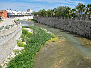
This is the case of the Girona river. It’s a Mediterranean river in the north of the Marina Alta county in Spain. It is dry most of the year, especially in summer. Girona river connects the mountains from the inside of the county to the coastal plain and the sea. Girona river has a big biodiversity value (fauna, flora and water quality) and close to it there is a protected natural park (a marsh) that gives shelter to different important migratory birds that visit Girona river at times. It preserves some examples of water heritage linked to the historical irrigation systems in the Mediterranean area. The river crosses several towns and infrastructures. It’s potential value is endangered by a lack of environmental awareness in urban planning. In the past, the river was useful and people had a bigger bond with it. Nowadays, It’s thought it’s just a place with no interest or a barrier you need to cross. Moreover, Girona river is known by flash floods, what means that people from downstream area is exposed to an important flood risk.
Author's perspective
I’m geographer. I grew up very close to the site, in the capital of the county: Dénia (45.000 inhabitants). Dénia is placed in the west corner of the Girona river plain, just 10km from the river bed. On 2007 a big flood caused a severe damage on the small towns near the river. I remember that day, it was the first time I saw a catastrophe like that. I was shocked by the images on tv. After the disaster I visited the damaged area. The mud was everywhere and the neighbours had been cleaning their homes for days. In some streets the water had reached almost 3 meters high. After the disaster, people began to ask questions: Why it happened? Could it be prevented? Who is responsible? Do we have an accurate flood planning? Are the authorities really worried about our lives? Because of the lack of answers and while the politicians were exchanging mutual accusations, people got organized in a civic platform. I was involved in this citizen platform to provide advice.
Landscape and/or urban context of your case
- Biogeography, cultural features, overall character, history and dynamics
- Illustrations: maps; sketches; short descriptive analyses
- Illustrations
- Yourimage.jpg
your visual
- Yourimage.jpg
your visual
- Yourimage.jpg
your visual
Analytical drawings
- Please use analytical drawing for visualising the conflicts/potentials of your site
- Analytical Drawings
- Your drawing.jpg
your drawing
- Your drawing.jpg
your drawing
- Your drawing.jpg
your drawing
- Your drawing.jpg
your drawing
Green Infrastructure benefits for this site
Look again at the multiple benefits of green infrastructure - what could be achieved in your site and which are most relevant?
Potential for multifunctionality
Green infrastructure has typically multiple functions. What could be achieved for your site in this respect?
Projective drawings
- How would you like this case to change in the near future? (in 1-2 years)
- you may add a short explanation here
- And how could it look like in 10-15 years?
- you may add a short explanation here
- Projective Drawings
- Yourdrawing.jpg
projective drawing
- Yourdrawing.jpg
projective drawing
- Yourdrawing.jpg
projective drawing
- Yourdrawing.jpg
projective drawing
Summary and conclusion
- 100 words approx.
Image Gallery
Please add further images/photos here
- Image Gallery
- Yourimage.jpg
your image text
- Yourimage.jpg
your image text
- Yourimage.jpg
your image text
- Yourimage.jpg
your image text
- Yourimage.jpg
your image text
- Yourimage.jpg
your image text
- Yourimage.jpg
your image text
- Yourimage.jpg
your image text
References
- please add your references here
About categories: You can add more categories with this tag: "", add your categories