Planting Design 2013 Working Group 24 - Case Study A
---> back to group page working group 24
AFFORESTATION IN CA MAU, VIETNAM
| Name | Afforestation in Ca Mau, Vietnam | |
| Location | Ca Mau province | |
| Country | Vietnam | |
| Author | Le Trang Nguyen | |

| ||
|
| ||
Rationale: Why is this case interesting?
Please give a short introduction to the site you have selected (not more than 150 words)
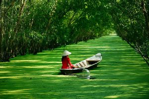
- Ca Mau, the southernmost province of Vietnam, is one of the lowest land in the world (only 0.5 - 1.3m). During a course of time, this region has been featured by an extraordinary geological movement, historical and economic changes, and nowadays facing climate change as the land is being taken away by the sea level. This area critically belongs to Mekong Delta, which is named as the "rice basket" of Vietnam.
- Afforestation is a strategy to develop scenarios to deal with environmental pollution, changing agricultural system, urbanization...and most of all, using forest urbanism as a scenario coping with flooding, submergence and soil salinity.
- In Vietnam, we address these Mekong Delta provinces as the most agriculturally profitable areas. But this also suffers from poverty, lack of education, pollution and a lot of social/political issues. I spent time in Ca Mau just enough to see massive mangrove forests cover the southern tip of the country. And after taking the online seminar "Climate Change" within Fluswikien framework, I started realising that nature soon takes over our country. I believe cautiously interacting with nature, using plants as critical materials is the right key to solve this problem.
Author's perspective
I have been practicing architecture profession for five years, few of my old projects happened to related directly to landscape architecture. My interest in landscape design grew through time then I decided to take two year course at IMLA (International Master degree of Landscape Architecture) in Germany. I believe plants should be considered as the major materials for designing nowadays, in the context of climate changing and urban interspace complex. I am now aiming to graduate as a landscape architect and bring plants and green space into my later career, instead of concrete and glass as what I did before.
Landscape and/or urban context of your case
- Biogeography, cultural features, overall character, history and dynamics
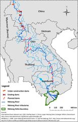
To understand Ca Mau's context, it is essential to have an overview of the whole Mekong Delta area. The Mekong Delta is a society where the waters of the Mekong River are present everywhere and in all the aspects of life, serving transportation, communication, fishing, agricultural, and aquacultural needs and all kind of daily domestic uses, often including drinking water. Life in the delta is greatly affected by the floods, rising and falling tides, and saline water intrusion from the sea. Water has always had two-sided effects in the delta. On one hand, the Mekong alluvium-rich waters bring many benefits to the area, such as soil fertility and productivity. On the other hand, the delta has been exposed to permanent threat of water disasters in the form of floods in the wet season and water scarcity and saline intrusion in the dry season. Attitudes toward the changing flow regime of the Mekong and the delta’s environment have been twofold, they have been characterized by human interventions and control but also by adaptation.
The conversion of marshes and forests of the delta into a landscape dominated by highly productive rice paddies did not happen without major human interventions. In 200 years, the delta has undergone dramatic ecological and economical transformation through major engineering and other public works, and its marshes, swamps, and forests have been turned into one of the main rice production and export areas of the whole world. Still, the society has had to learn how to live with the changing flow regime of the Mekong River caused by the monsoon climate and with the changing periods of both too much and too little water. For a long time, livelihoods and farming systems were characterized by adaptation to the changing environmental conditions. In upper parts of the delta, floating rice suited to the local flood and tidal regime grew along with rising flood water, and was thus fed by it, and was harvested after the flood receded. In areas near the coast, the period with brackish water was avoided, and rain-fed rice was sown when the rains started and harvested before the intrusion of brackish water.
However, especially in the last decades, actions toward the environment have shifted strongly from adaptation to control and, at the same time, from decisions made at the farm level to centralized decisions on greater scales. The large-scale hydraulic control structures have targeted mainly the floods in the upper part of the delta and saline intrusion in the coastal areas. Thus, the Vietnamese Mekong Delta is currently one of the most human-regulated water regimes of the basin and has much more flow-independent farming systems than, for example, the floodplains of Cambodia.The combination of the hydraulic control structures and agricultural modernization in terms of high-yield rice varieties and agrochemicals has made the delta an incredibly productive rice area, but along with higher yields and production goals, there have also been such environmental consequences as worsening of the water quality, diminishing biodiversity, increased demand for water, and increased saline water intrusion. The modified distribution of water has also changed the distribution of risks: new canals and new control structures bring floods and saline intrusion to new areas. The costs and drawbacks of the engineering works have not been distributed evenly. As is often the case, it seems that the most disadvantaged group is that of the poorest farmers and landless people.
In that context, Ca Mau with its southest location and longest coastline, is the most vulnerable area. Along with geological movement, this area expereriences adaptation as well as human control, at the same time exposes all complex demographic matter. Yet, this contains the most colourful biodiversity, many spieces are now in red list. Mui Ca Mau’s wetland was listed in Recommendation of National Marine Priority by Ministry of Aquiculture in 2005. It was also listed to nominate as coastal Ramsar site in 2006. In 31/05/2007, Vietnamese Prime Minister approved the “National Action Plan for Biodiversity to 2010 and Strategy to Implement Biodiversity Convention to 2020”, inside, Mui Ca Mau is one of critical sites for conservation, development and sustainable use of biodiversity in Vietnam.
The proposed Mui Ca Mau Biosphere Reserve has an area of 369,675 ha with 170,321 people living there. There are three core zones encompassing the stricly protected core zones of Mui Ca Mau National Park, U Minh Ha National Park and the coastal protected forests in Ca Mau Western. They are typical ecosystems that meet the UNESCO’s criterion such as example mangrove forest ecosystem, peat wetland ecosystem, marine ecosystem, etc.. Each contains abundant biological and geological resources with high conservation, and has been preserved by international natural conservation organizations.
- Illustration: Map; sketches; short descriptive analyses
Analytical drawings
Please add four analytical sketches/drawings (or montages/schemes) of your case and take the following aspects into account:
- natural dynamic versus cultural framework - in how far do these two forces come together in your case?
- dynamic through the year (you may imagine how the site looks in spring and summer, maybe you also remember it)
- highlight potentials and problems
- Analytical Drawings
- Yourfilename1.jpg
analytical drawing 1
- Yourfilename2.jpg
analytical drawing 2
- Yourfilename3.jpg
analytical drawing 3
- Yourfilename4.jpg
analytical drawing 4
Projective drawings
- Please add four projective sketches/drawings (or montages/schemes) for your case and take the following aspects into account:
- How would you like this case to change in the near future? (in 1-2 years)
- And how could it look like in 10-15 years?
- Projective Drawings
- Yourfilename1.jpg
projective drawing 1
- Yourfilename2.jpg
projective drawing 2
- Yourfilename3.jpg
projective drawing 3
- Yourfilename4.jpg
projective drawing 4
Summary and conclusion
Please summarize your case and give arguments for your projective design (approx 150 words).
Image Gallery
You may add a series of images/photos in addition to the sketches/drawings
- Image Gallery
- Yourfilename1.jpg
image 1
- Yourfilename2.jpg
image 2
- Yourfilename3.jpg
image 3
- Yourfilename4.jpg
image 4
References
* Please make sure that you give proper references of all external resources used.
* Do not use images of which you do not hold the copyright.
* Please add internet links to other resources if necessary.
About categories: You can add more categories with this tag: "", add your categories
