Caulim Creek Neighborshed
Green Infrastructure for the Informal Settlement in the Watershed Area of São Paulo Metropolitan Region (Brazil)
Rationale: Why is this case study interesting?
As a case study for a pilot-project, it was chosen the Caulim Creek Neighborshed, one of the streams that is included in the State’s Water and Sanitation Company Program of Clean Streams. This case study is interesting because it can depict a proposal of landscape plan and design as green infrastructure for an area where the conflict between the urban growth and the nature preservation seems contradictory, and could explicit how environmental problems are inseparable from the economic and social realms in an emergent mega-city.
Author's perspective
Green infrastructure for informal settlement in São Paulo Watershed Area
Green infrastructure is the network of connected open spaces where a myriad of landscape elements integrate natural processes in the urban fabric. It represents a way of taking advantage of ecological services for promoting sustainability and conservation of natural resources in the urban areas and its surrounding region.
Landscape and urban context
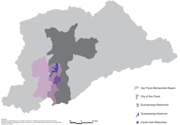
The city of Sao Paulo is the State capital of São Paulo, along with 38 other cities composing the Sao Paulo Metropolitan Region.
Sao Paulo Metropolitan Region has almost 20 million inhabitants in an area of 8,000 km2. It is located on a plateau at 800 meters high and about 70 kilometers from the sea. It has GNP of U.S. $ 171 billion, equivalent to 63% of the GNP of São Paulo State and 20% of Brazilian GNP.
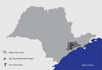
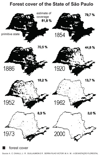
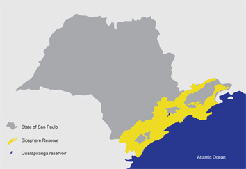
Sao Paulo Metropolitan Region is part of the Biosphere Reserve of the Atlantic Forest. The Biosphere Reserves are areas of terrestrial or aquatic ecosystem proposed by UNESCO, which have significant environmental value and are recognized internationally. The Atlantic Forest is a Hot Spot, which is one of the most biologically rich regions and also one of the most endangered of the world. The Atlantic forest occupied 1,200,000 km2, almost continuously throughout the Brazilian coast. The State of Sao Paulo had about 81% of its territory covered by Atlantic Forest. After several decades of intense urban growth and devastation of native vegetation, now only about 3% of the State's territory is covered by forest.
In the State of Sao Paulo, the Biosphere Reserve has as some of its objectives the conservation of plant and animal biodiversity, the quality of air, soil conservation and production of quality water to supply.
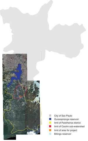
In the Sao Paulo Metropolitan Region most of the drinking water comes from the reservoirs in the southern limits (Guarapiranga and Billings).
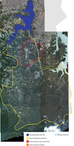
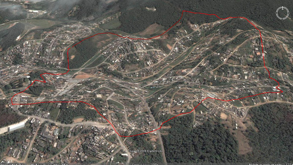
The proposed area of study comprises the sub-watershed of a tributary of the Caulim creek, in the administrative district of Parelheiros.
Caulim Creek is one of the rivers which supply the Guarapiranga resevoir and receives an intense load of sewage in the district of Parelheiros.
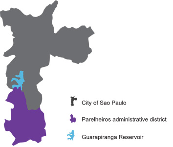
The Caulim Creek project area borders the environmental protection area that is still preserved . Home of 20.000 people, it is a sector of 200 km2 in the watershed area where is still possible to find streams not yet channelized and remaining forests patches, and where the sewage catchment system is already set. Despite the sewer system, the density and pattern of settlements in the watershed will cause flooding and water quality impacts.
Cultural/social/political context
This watershed area was declared protected by law 30 years ago, not allowing conventional developments. Instead of it, since then many informal low-income settlements were built on the once-forested areas of the watersheds, decreasing the water quality and increasing the cost of water filtration and treatment. In this process of settlement, most of the forest that once covered the margins of the reservoirs lakes was changed to high density self-constructed housing among not planned streets where now lives more than 1.6 million people. The public administration has now concentrated efforts to improve housing and urban infrastructure in these neighborhoods. Nevertheless, these projects follow the conventional way of building the city as a paved and build surface where the remaining vegetation is considered primarily for ornamental functions.
History
There are details of that southern city of Sao Paulo was formerly inhabited by Tupi Indians. In the twentieth century, the Guarani, a subgroup Tupi reached Parelheiros and it has set. Remnants of that core are two villages that still exist in the region, with 600 indigenous.
These two villages are located within the Area of Environmental Protection Capivari-Monos, which occupies 70% of the territory of Parelheiros. Within the Environmental Protection Area, there is also a Crater of Colony, a formation with 3.5 kilometers, caused by the impact of a celestial body on Earth, millions of years ago. After the construction of Guarapiranga Reservoir, between the years 1906 and 1912, and Billings Reservoir, in 1927, the interest in the southern city of Sao Paulo increased. The reservoirs created a potential for leisure in the region, resulting in intense property speculation around lots for construction of recreational facilities. Country houses, clubs and spas camp came to characterize large areas of the outskirts of the reservoirs.
From 1940, Parelheiros becomes an option for affordable housing for employees of industries located in neighboring districts, such as Santo Amaro. There was an intensive growth of the area built the margins of junctions of roads or pre-existing rural towns. In the decades of 1950 and 1960, the State of Sao Paulo was an intense process of industrial expansion, which resulted, among other things, the expansion of the Industrial Park of Santo Amaro, inducing urban growth toward Parelheiros.
In 1975 was promulgated the The Law of Watershed Protection and the Law of industrial zoning. There was, thus, limits the deployment of new industries and control the expansion of existing ones. However, the legislation relating to water sources was insufficient to contain the advance of urbanization and environmental degradation.
Spatial analysis of area/project/plan
Survey of areas with 25% or more slope.
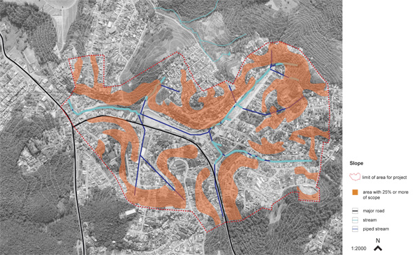
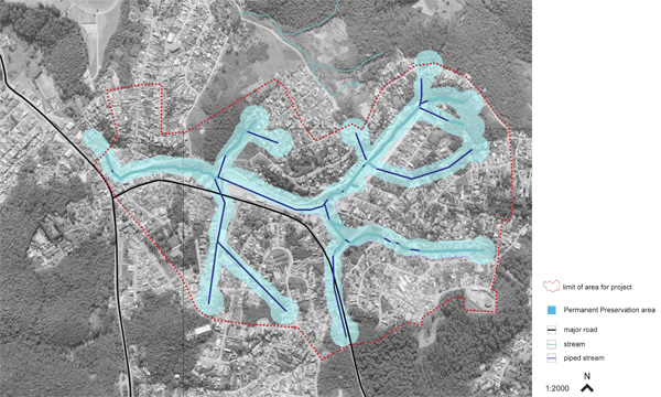
According to the Environmental Law, is considered permanent preservation area of the range of 50 meters around springs and range of 30 meters around water courses of up to 10 meters wide.
The Environmental Law considers the natural water flow to set the limits of protected areas around the water bodies, which are areas that flooding, must therefore not be occupied.
On that basis, the survey of the areas of permanent preservation was made.
Core Questions Working Group Green Structure Planning
How does funding influence the planning and use of public space?
Caulim Creek is present in Stream Clean Program, launched by the Government of the State of Sao Paulo in partnership with the Mayor of the City of Sao Paulo and Environmental Sanitation Company of the State of Sao Paulo. The Program envisages the improvement of the system for collecting and cleaning of drains and urbanization of the banks of streams. In a first phase, are invested 200 million reais in 42 streams, benefiting 2.4 million people in an area of 204 km2, within two years. However, the schedule provides that 300 streams will be cleaned in a period of ten years. Caulim Creek is in the first phase of the investment Program and will receive an investment of 1.35 million reais.
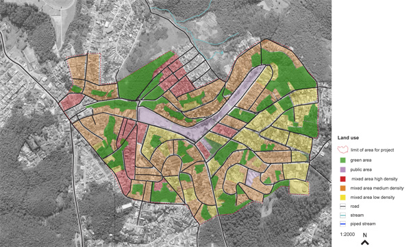
How are spaces within the site used, both currently and projected?
The area selected for the development of Green infrastructure project is part of the Caulim Creek Sub-Watershed, which has a population of about 20 thousand people and an area of approximately 9.62 km2.
How can the historic elements / layers be integrated?
The Crater of Colony, the indigenous villages and the natural and geographical characteristics of the region indicate the possibility of development an eco-tourism in the district of Parelheiros.
The presence of significant remaining forest and water strategic importance of the region justify the necessary preservation of natural resources and the establishment of sustainable uses and activities.
In the study area, the green areas and the others green infrastructure elements can be ecological corridors that connect the adjacent existing forests.
How do the contributing elements of water relate to the project?
The watersheds of Sao Paulo Metropolitan Region are areas where an important conflict between urban sprawl and preservation of the environment is depicted. The Law of Watershed Protection, enacted in 1975, has imposed restrictions on the use and occupancy of the soil, allowing only the occupation rather intensive with low limits of density in the areas of water sources. Nevertheless, these areas of importance to the quality of water resources, formerly covered by forests, have been occupied by popular houses, in general, informal, irregular, precarious and without planning.
The waters of the Guarapiranga Reservoir are used to supply approximately four million inhabitants of the Sao Paulo Metropolitan Region, which is composed of 39 municipalities with a population of nearly 20 million inhabitants. The Watershed areas occupy 52% of the Region and totally or partially cover 25 municipalities. They represent more than 10% of urbanized area and house 18% of the slum areas throughout the metropolitan region. They have a population of over 1.6 million people and concentrate 70% of what remains of natural vegetation in São Paulo Metropolitan Region.
The Guarapiranga Watershed has a drainage area of 63,911 hectares (or 639 km2) and is currently the second largest spring system to supply the São Paulo Metropolitan Region. Of the households in the region, 54% have sewage collection system, septic tanks with 16% and 30%, or 59 thousand households, dumping their sewage into ditches and water courses. More than 22 thousand households (11% of total) do not have water supply service.
Therefore, the regional use of Guarapiranga watershed’s water resources indicates the importance and the necessity of environmental preservation of natural resources.
Accordingly, the green infrastructure can be a strategic alternative to the Environmental Planning of Guarapiranga watershed.
The green infrastructure is a valuable solution for the management of water resources and provides many other benefits, such as the enhancement of social use of space, the promotion of better quality of life and nature conservation.
How does the built environment relate to the landscape around it?
The system of infrastructure deployed in Brazilian cities does not recognize the existing natural processes, which ultimately generate numerous environmental problems like air pollution, the landslides, scarcity of water and flooding, affecting the health, quality of life and welfare. The conventional urbanization has as one of its features, the deployment of an urban drainage system responsible for the deterioration of water quality and the increased production of sediment and the frequency of flooding. The floods become more frequent due to excessive sealing of areas, the increase in maximum flow rates (resulting from increased velocity of flow) and the reduction of the capacity of disposal. The production of sediments increases due to construction, cleaning of land for new lots, construction of roads, the generation of solid wastes, and so on. In addition to the sand drainage and reduce the ability to flow into conduits and bodies of water, sediment can carry pollutants, contributing to the pollution of water resources and deterioration of water quality.
Analysis of program/function
- What are the main functional characteristics?
- How have they been expressed or incorporated?
Illustration: Map/diagram/sketches photos and background notes
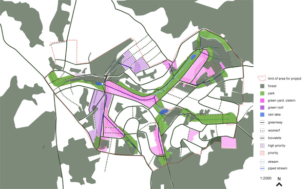
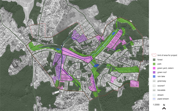
The green infrastructure for Caulim sub-watershed has as axes the management of water resources and the preservation of biodiversity. The proposed system are described below:
Biodiversity Protection Areas (BPA): forests, parks, flooded áreas and other spaces to be preserved in its natural state. Its main functions and benefits: the preservation of biodiversity, soil protection, damping peak of flooding, recharge of aquifers, improved climate through the mitigation of heat islands and increase the relative humidity.
Flooded (F): flat areas of wetlands that are flooding, around springs and streams. Can be natural wetlands or constructed. Its main benefits: improvement of water quality (through the filtering performed by plants that inhabit this type of ecosystem), damping of peak flood (the storage capacity of water in wetlands), and corridor for wildlife habitat for many species.
Green Yard (GY): yards, gardens and green spaces in homes, schools, public or private equipments. These areas may include resources such as water, food and places for animals sheltering and procreating.
Urban Forest (UF): includes all the green managed in the urban areas, such as the Greenways (GW). The urban vegetation is important to the life quality in cities and provides numerous benefits, such as the improvement of local climate, the reduction of heat island effect, the increasing of relative humidity, the control of soil erosion, the decline of air pollution, etc.
Rain Garden (RG): depressions in the ground, existing or consructed which have the function of storing and infiltrate the rainwater from roofs and other waterproof areas. The plants and microorganisms in the rain gardens help to remove the diffuse pollutants.
Flowerbed Rain (FR): small rain gardens, compressed into small urban spaces.
Biovalets (BV): Gutter of vegetation which have the function of flow, retain and infiltrate rainwater. They have similar role as the Rain Garden, but are generally linear depressions, which increase the time of Rainwater draining, leading them to the rain gardens or to the conventional systems of water retention.
Green Roof (GR): buildings roofs with vegetation. Absorb rain water, create habitat for wildlife, increase the life of the roof and improve better local climate, increasing air humidity.
Cistern(CS): are structures for rainwater storage. Contribute to alleviating the floods, retaining part of the volume of rain that falls. The water can then be used for activities such as watering, cleaning floors or be set out to the drainage system after the reduction of water volume in the system.
Woonerf (WF): the vehicles are secundary on the use of the streets. It becomes a space for mixed uses for pedestrians, children playing, cycling, etc.. The street have other features that can coexist with the presence of vehicles.
Bicycle ways (BW): specific routes for bicycles. Benefit the environment because stimulate changes in the pattern of mobility in the local traffic, reducing the number of cars and other vehicles.
Analysis of design/planning process
- How was the area/project/plan formulated and implemented?
- Were there any important consultations/collaborations?
Illustration: Map/diagram/sketches photos and background notes
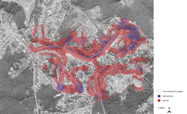
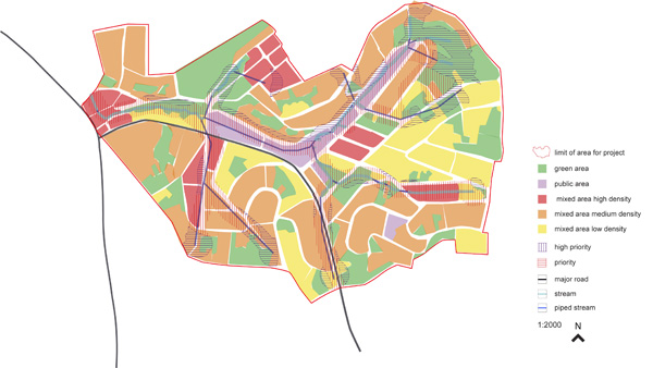
From the limiting factors slope and flooding were defined areas of priority and high priority. These are priority areas for the implementation of green infrastructure.
Analysis of use/users
- How is the area/project/plan used and by whom?
- Is the use changing? Are there any issues?
Illustration: Map/diagram/sketches photos and background notes
Future development directions
- How is the area/project/plan evolving?
- Are there any future goals?
Illustration: Map/diagram/sketches photos and background notes
For the green infrastructure project were set the following guidelines:
1. Connect the green areas for the conservation of remaining forests and biodiversity;
2. Bring the river to the city, using the streams not piped to insert them in the public space (valued and implemented by the green infrastructure);
3. Contain urban sprawl;
4. Actions must consider the proximity to the remaining forest and the intensity of consolidated urbanization.
From these guidelines:
a) In areas of high priority and where there is direct connection with remaining forest, there will be expropriation and introduction of public green areas;
b) small urban nucleus that are surrounded by forest are also expropriated to contain urban sprawl;
c) Because of the roads are the principal inducing of urban sprawl, the creation of woonerf can be a strategy to contain the advance of the occupation in blocks where the streets are deadlocked or that end in an area where urbanization is not yet consolidated.
d) steep roads will have biovaletas
e) The areas that have low or medium density, with residential use or not, will have green yards.
f) In areas of high density, the use of cisterns, green roofs and rain flowerbeds.
g) People who were expropriated will be relocated in the Special Zone of Social Interest, defined by the Master Plan of the Municipality of Sao Paulo.
Peer reviews or critique
- Has the area/ project/plan been reviewed by academic or professional reviewers?
- What were their main evaluations?
Pleas add references, quotes...
Points of success and limitations
- What do you see as the main points of success and limitations of the area/project/plan?
Illustration: Summary table
What can be generalized from this case study?
- Are there any important theoretical insights?
Short statement plus background notes
Which research questions does it generate?
Short statement plus background notes
Image Gallery
- Yourimage.jpg
your image text
- Yourimage.jpg
your image text
- Yourimage.jpg
your image text
- Yourimage.jpg
your image text
- Yourimage.jpg
your image text
- Yourimage.jpg
your image text
- Yourimage.jpg
your image text
- Yourimage.jpg
your image text
- Yourimage.jpg
your image text
- Yourimage.jpg
your image text
References
Please add literature, documentations and weblinks
About categories: You can add more categories by copying the tag and filling in your additional categories

