Group J - Collaborative Climate Adaption Project
| Area | Venetian Lagoon | |||||||||||
| Place | Venice | |||||||||||
| Country | Italy | |||||||||||
| Topic | Subsidence of Venice | |||||||||||
| Author(s) | Alisan Gül, Anna Slosberga, Lena Penezic | |||||||||||

| ||||||||||||
| {{#widget:GoogleMaps | width=300 | height=200 | lat=45.4386111 | lng=12.3266667 | zoom=11 | centermarker=yes | maptypecontrol=yes | overviewmapcontrol=yes | largemapcontrol=yes | scalecontrol=yes
}} | ||
Rationale: Why have you selected this case study area?
- Please summarize:- e.g. previous experience, is it your everyday environment?, specific vulnerability, previous research being done etc.
Venice is a World heritage City with unique historic architecture and has its own culture within Italy. We have selected the lagoon of Venice because of the city's architectural, historic, cultural and economical importance as it is the most popular tourism destination in Italy.
The City of Venice is endangered to go under water within few years. The specific vulnerability of the city is caused by three main reasons such as the morphology of the site, the anthropogenic impact and the rise of the sea level in a result of the climate change. The underground of the lagoon is sinking due to the tectonic movements. This process was speed up by the Venetians as they pumped down a great deal of groundwater and built shipping channels under the lagoon destroying the ecosystem of the lagoon and greatly contributing to the subsidence of Venice.
For safeguarding the Venetian lagoon there are some plans from firms like CREA and a project M.O.S.E.
Authors' perspectives
- What theoretical or professional perspective do you bring to the case study?
We are a team of landscape architecture students with various ethnic and professional background. As we all appreciate the unique value of the City of Venice we have chosen it as our case study area to apply the theoretical knowledge of the climate change adaption and mitigation measures. Unfortunately people notice danger very late and Venice is a good example of the human irresponsibility towards the nature and the environment. As the City of Venice was built on the weak underground of the lagoon, it has deformed the functions of the lagoon and destroyed the local ecosystem. In general the same imprudence can be observed in terms with the global environment, for instance, many countries still can not efficiently reduce the GHG's to mitigate the climate change. We are using the example of Venice to combine both specific and universal measures for climate change adaption and mitigation.
Landscape and/or urban context
Venetian Lagoon
Lagoon – lat.lacus, "lake" –international name for an enclosed, shallow embayment of salt water. The drainage basin, also known as Il bacino scolante is the area where the surface water network (under conditions of normal flow ) flows in the lagoon of Venice.The surface of the drainage basin is composed of two areas: the territories of the tributaries of the river basin surface waters which open in the lagoon of Venice; the territories that affect water bodies draining of the lagoon of Venice by the spring waters, identified as Charge Area. In addition, an Agency for Prevention and Protection of the Veneto Region has been made, also known as ARPAV . http://www.arpa.veneto.it/temi-ambientali/acqua

http://www.arpa.veneto.it/temi-ambientali/acqua/acque-interne/bacino-scolante-1

The image shows the Padua-Treviso-Venice Metropolitan Triangle (the orange triangle on the map), and the Venetian Lagoon (the red striked area). This image is used to make an idea of the wider area of Venice - the important metropolitan complex and the great basin area which includes a lot greater plan than Venice itself.
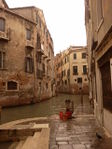
Venice (Latin: Venetia)) is a city in northeast Italy sited on a group of 118 small islands separated by canals and linked by bridges. It is located in the marshy Venetian Lagoon which stretches along the shoreline between the mouths of the Po and the Piave Rivers, rather from the Sile on the north and the river Brenta on south. The whole area is listed as a World Heritage Site, UNESCO. Venice is the capital of the Veneto region which consist the whole Comune of Venezia; the historic city of Venice (Centro storico); Terraferma (the Mainland), Mestre and Marghera. Together with Padua and Treviso, the city is included in the Padua-Treviso-Venice Metropolitan.

Here can be seen that Venice consist a lot urbanised and built areas, and almost no areas of greenery.
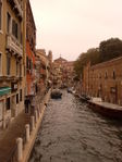
As it can be seen, Venice is an overbuilt island, known as the Floating City which has no greater green areas or green infrastructures. Venezia is a city of small islands, enhanced during the Middle Ages by the dredging of soils to raise the marshy ground above the tides, so it's a manmade landscape. The resulting canals encouraged a nautical culture, which provided central development of the city. Today those canals (more than 400) still provide the means for transport of goods and people within the city.'High water' (Italian: Acqua alta ) is the term used in Veneto for the exceptional tide peaks that occur periodically (autumn and spring) in the northern Adriatic Sea. The peaks reach their maximum in the Venetian Lagoon, where they cause partial flooding of Venice and Chioggia.

Cultural/social/political context
Venice is a product of a Mediterranean and European Culture, founded in the early 9th Century. The Lagoon of Venice is the most important survivor of a system of estuarine lagoons - In the sixth century, the Lagoon gave security from fleeing invaders (mostly the Huns), later, it provided naturally protected conditions for the growth of the Venetian Republic and its maritime empire. It still provides a base for a seaport, the Venetian Arsenal, and for fishing, as well as a limited amount of hunting and the newer industry of fish farming.
Population Population : 270,884 Density (per square km): 656.6
Recently, the residential population of Venice has decreased dramatically, due in part to flooding concerns. In addition, much of the general public consists of tourists, students of the University of Venice, and business owners.
Governent The Venice Lagoon is mostly included in the Province of Venice, but the south-western area is part of the Province of Padua.
The city is divided into six areas or "sestiere". These are Cannaregio, San Polo, Dorsoduro (including the Giudecca and Isola Sacca Fisola), Santa Croce, San Marco (including San Giorgio Maggiore) and Castello (including San Pietro di Castello and Sant'Elena). Each sestiere was administered by a procurator and his staff. Other islands of the Venetian Lagoon do not form part of any of the sestieri, having historically enjoyed a considerable degree of autonomy.
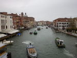
The Grand Canal
Canal Grande the greatest canal in Venice. It forms one of the major water-traffic corridors in the city. Public transport is provided by water buses (Italian: vaporetti) and private water taxis, and many tourists explore the canal by gondola. One of many symbols of Venice - Gondola
http://en.wikipedia.org/wiki/Grand_Canal_(Venice)

The Canal is lined with more than 170 buildings, most of which date from the 13th to the 18th century, and demonstrate the welfare and art created by the Republic of Venice. Amongst the many are the Palazzi Barbaro, Ca' d'Oro, Ca' Foscari, Palazzo Barbarigo and to Palazzo Venier dei Leoni, housing the Peggy Guggenheim Collection. The churches along the canal include the basilica of Santa Maria della Salute. Centuries-old traditions, such as the Historical Regatta, are perpetuated every year along the Canal.
Because most of the city's traffic goes along the Canal rather than across it, only one bridge crossed the canal until the 19th century, the Rialto Bridge. There are currently two more bridges, the Ponte degli Scalzi and the Ponte dell'Accademia. A fourth, controversial bridge (Ponte della Costituzione) was recently erected As was usual in the past, people can still take a ferry ride across the canal at several points by standing up on the deck of a simple gondola called a traghetto. Most of the palaces emerge from water without pavement. Consequently, one can only tour past the fronts of the buildings on the grand canal by boat.
Carnevale
Maybe the major manifestation in Venice, the world wide known Il Carnevale di Venezia - Venice Carneval. A few weeks before Easter, a ten-day festivity takes place on the streets of Venice. It culminates with a lavish display of fireworks above the Grand Canal. During Carnevale, Venetians dress in 18th century costume and famously wear elaborate masks, completely disguising their identities. There are organized balls, various musical and theatrical events.
Rialto market Culinary, social and economic heart of Venetian life, where locals buy their seafood, meat and other producrts. This small island, originally known as Rivoaltus, was one of the first to be settled by early Venetians, and by the 11th century had become the town’s central marketplace.
Local Climate
The climate in Venice is Mediterranean, but due to the surrounding sea it is rather wet throughout the year. Venice`s tempered climate is characterized by mild temperatures that rarely go under 0°C in winter and above 35°C in summer time. The average precipitation in Venice is 854 mm per year[[1]].


The two most important winds blowing over Venice are Bora and Sirocco. Both can be observed at all seasons. Bora is a dry and cool wind blowing from the north-east while Sirocco is a humid and warm wind blowing from the Sahara desert. Sirocco along with the lunar cycles and the Adriatic tides is responsible for the phenomenon of acqua alta (high water).
Historically the high water was characteristic to Venice in spring and autumn with its peaks in November and December. Nowadays the situation has changed and the flood events occur around 60 to 100 times a year. The severest flood in the history of Venice was experienced in 1966 when the level of the lagoon rose 194 cm above its normal level. In 2012 Venice experienced exceptional high waters even twice. [[2]]
The climate change significantly influences the air circulation of the North hemisphere. Those changes manifest as the heat waves and extreme pressure differences that increase the strength of Sirocco Winds resulting as more frequent and disastrous floods in Venice.
Accordingly to the European Environment Agency Venice, same as the majority of the Mediterranean region, will experience a significant increase of heat waves combined with a temperate decrease of precipitation during this century. The global warming will also have a serious impact on the rise of the sea level that in accordance with the latest IPCC (Intergovernmental Panel on Climate Change) report can reach 88 cm in the worst-case scenario [[3]].
- What are the climatic conditions at present? Have there been extreme weather events in the near past?
- Which changes are expected? Is there any evidence?
Illustration: Table or time line
Analysis of vulnerability
The flooding caused by the acqua alta is not uniform throughout the city of Venice because of several factors, such as:
1. the varying altitude of each zone with respect to the conventional sea level,
2. the distance from a channel,
3. the relative height of the sidewalks,
4. the presence of full parapets (which act as dams) along the proximate channel,
5. the layout of the sewer and water drainage network (which acts as a source for the flooding, as it is directly connected with the lagoon).
The studies have shown that tides up to 90 cm above sea level leave Venice virtually unaffected. The sirens that forecast high water 3-4 hours in advance go off if the level is expected to be above 110 cm because with this height 12% of Venice is covered with water. The studies have provided the correlation between the sea level and the percentage of submerged area of Venice [[4]] .

The previously described worst-case scenario regarding the sea level rise of 88 cm within this century due to the climate change would lead Venice to very high and exceptional high tides almost daily. Meaning that without appropriate adaption measures more than 50% of Venice would constantly lie under the water causing irreversible all-inclusive damage effecting citizens daily life, architectural and cultural values, economics etc.
- If you consider these potential changes - which aspects/functions of your case study would be affected?
Illustration: Map/diagram/sketches/photos/background notes
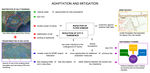
Proposals for Climate Change Adaption
Note: All the mitigation and adaptation measures are conceptual ideas. There is a need of more analyses and valuation, ecological, technological and other ones.
MOSE PROJECT

[[5]]
The MOSE (Modulo Sperimentale Elettromeccanico, or Experimental Electromechanical Module) Project has been created to protect Venice against the floods. It involves the construction of a set of 79 floodgates that will separate the lagoon from the Adriatic. The engineering solutions of those devices will provide no negative effects on the vistas of Venice as the gates are designed to lie flat on the seabed and are planned to be risen only during the extremely significant tides. [[6]] Although the MOSE project will probably prevent the unique architectural and cultural sites of Venice from going under the water it is also predicted to cause an irreversible damage to the local ecosystems of the lagoon. As the mobile floodgates are under construction according to the MOSE project, the ecosystems of the lagoon have become the most vulnerable value that now is put under the considerable risk. The environmental sustainability within the MOSE project can be provided only with condition that the floodgates get risen not more than few times a year for a short period of time.
Other options to safeguard Venice against tides:
- to raise the foundations
- to reduce depths at the 3 entrances of the lagoon
- to restore wetlands
- to redesign jetties to slow tides
- to inject sea water under the underground of Venice.
"The seawater would be pumped into a number of sandy layers ... between 650 and 1,000 meters' depth. "The presence of a clay cover above ensures that the injected seawater will not flow upward. Water will diffuse laterally within the layers it is pumped into.", Gambolati, a hydrologist at the University of Padua in Italy.
According to the plan, a dozen wells surrounding Venice in a ten Kilometer circle would pump water into the ground - over a ten-year period nearly 40 150 billion liters. The plan is also economical, certainly in comparison with the MOSE system. This project of injection would raise the city by 25–30 cm over 10 years. [[7]]
TRANSFORMATION OF SEA GATES
A few principal deep channels (max. depth 15 m) cross an area of very shallow water with an average depth on the order of one meter. There ate three main inletss, called Lido, Malamocco and Chioggia that are the main channels which let the tide propagate into the lagoon. These natural channels are from 500 to 900 m wide and up to 15 m deep. The main driving forces for water circulation within the lagoon are tides and wind. Tides have an average tide range of about 60cm - 1m excursion

Lido – being the bigger one of the three channels , Lido lets more sea water into the lagoon and directly influences the most. By narrowing it , there would be potentially less water and less flood damage.
An other measure could be closure (sea-level gates) of one channel. With sea-level gates there could be a greater control over both, shipping traffic and water tides.
Sea - level gates - How it works , Panama canal [[8]]
Closure of the one of the existing three sea gates and narrowing of the two remaining could lead to smaller costs for MOSE project realization, more opportunities for additional adaptation measures. Moreover it could be an opportunity for additional mitigation measures like less shipping traffic and cruise ships, les day-trippers.
RESTORATION OF SALTY MARSHES
Understanding the "estuary", how it works is the key of this approach and design. The word estuary is derived from the Latin word aestuarium meaning tidal inlet of the sea, which in itself is derived from the term aestus, meaning tide. The definition of the estuary as a semi-enclosed body of water connected to the sea as far as the tidal limit or the salt intrusion limit and receiving freshwater runoff, is the most wide concept, for understanding its work.[[9]] So, the tide is a natural phenomena that is essential for the work of the existing lagoon and its potential biotope and ecosystem.
Why Are Salty - marshes Important?
Salty-marshes are among the most productive ecosystems on Earth. Coastal habitats provide spawning grounds, nurseries, shelter, and food for finfish, shellfish, birds, and other wildlife. So, creating a coastal wetland would be a natural approach to reduce power of the waves, stabilizing the soil, to reduce the level of CO2, to clean the water of the lagoon and eventually reduce the flood damage to the city.
Digging out the sand from the depth and silting it into dikes would, in first place, create spots with a greater depth which could potentially reduce the water level and the new dikes would be a natural banner to the power of greater waves and floods. A great quantity of biofilters would filter the water and create new habitats as an opportunity for new ecosystems.
The CWPPRA, Coastal Wetlands Planning Protection and Restoration Act Program, USGS National Wetlands Research center, Louisiana give some of Restoration Techniques [[10]] :
Restoration Techniques
• marsh creation and restoration • shoreline protection • hydrologic restoration • beneficial use of dredged material • terracing • sediment trapping • vegetative planting • barrier island restoration • bank stabilization
Elements common to wetland project design are site-selection criteria, hydrologic analysis, water source and quality, substrate augmentation and handling, plant material selection and handling, buffer zones placement, and long-term management[[11]]

A major inlet of the Lagoon.Greater tides directly flood Venice, Lido and other minor islands. Silting new dikes in the shown zone would be a natural barrier to waves and greater flood.
 A concept of a restoration of a Coastal Wetland.
Proposals for Climate Change Mitigation
According to CDEMA [[12]] , Mitigation of flood refers to any structural or non-structural measures undertaken to limit the adverse impact of hazards. Structural o Non Structural [[13]].
Structural measures are in the nature of physical measures and help in “modifying the floods”, while non- structural measures are in the nature of planning and help in “modifying the losses due to floods”. All of these works can be individually divided into long term and short-term measures. One measure or policy won't remedy the damage done. Rather, an integrate approach that simultaneously implement the measures, enforce the law could trough some period improve the general condition of the city.
We provided some ideas that would consist both, structural and non-structural measures.
Sustainable tourism


As Venice is the city with the highest tourist-to-resident ratio in Europe it`s municipality should put all the possible effort to popularize sustainable tourism. The size of the host community of the Historic center of Venice, that is the most visited part of the city, has considerably decreased during last ten years now being under 58 000 although historically 200 000 inhabitants used to live in this part of Venice. At the meantime the number of tourists has been constantly growing year by year and it is estimated to range from 20 to 22 million in 2012 [[14]].
Sustainable tourism is based on simple code of ethics “First, do no harm” and it seeks to avoid the “loved to death” syndrome. Within sustainable tourism businesses and other stakeholders apply limits and management techniques that sustain natural habitats, heritage sites and local culture. It also concentrates on conserving resources [[15]]. Sustainable tourism contains three main elements: sociocultural, environmental and economic. As the greatest part (almost 90%) of tourists visiting Venice are day-trippers the existing overload of visitors do not contribute even to the city`s economics.
In order to obtain more sustainable tourism several simple recommendations should be advised to city`s visitors:
- to choose environmentally friendly means of transport as often as possible – public transportation, gondolas, bicycles and walking;
- to favor locally run, private restaurants instead of international chains of catering industry;
- to reduce the amount of produced waste by choosing products without packaging and drinking the tap water instead of bottled water;
- to respect local customs and to avoid offensive behavior;
- to not take away souvenirs from the natural environment [16][17]].
In order to propagate the sustainable tourism among city`s visitors the information should be spread using various channels. An informative brochure based on the existing webpage should be created and distributed in hotels, souvenirs shops and on the air plains lending at Venice`s airport. The educative work should also be done by posting information boards in the most popular tourism destinations within the city.
Venice is an built area with almost no greenery. It would be useful to set a building policy that require more green areas, as tree lines along the coast and parks. There should be made Flood Plain Zoning Maps which places restrictions on the use of land on flood plains. It could reduce the coast of flood damage.
Flood zoning maps
Zoning as a legal tool used by governments to control development, should be enforced in areas which are prone to flood. According to BSDMA - Mitigation of Flood [[18]] Flood zoning maps place restrictions on the use of land on flood plains, and in addition can reduce the cost of the damage.
For a zoning it would be needed:
- an integrative planning team which implies professions as planners, geographers,landscape architects, architects,urban planners, economists,lawers, politians, sociologists etc.
- strategies that are implemented in the policy of the State, which implies measures that are implemented in everyday life such as building codes, assistance, tourism, development, industry etc.
- monetarily enforcing professions that deals with planning, landscape, geography, development, indusrty, building, land construction, hidrotechnology...
- Monetar sanctions, tourism monetar incomes etc could be used for purchasing flood insurance to help cover the cost of damage from floods.
- Forecast teams that would allert the citizens at time to prevent bigger issues
Your scenario
 [[19]]
Several gloomy scenarios exist reflecting the very dark future of Venice some of them predicting not only the destruction of the City itself but also extinction of the whole lagoon due to the sea level rise of 2 meters or more during the 21st century. Obviously with so great elevation of water level none of the existing adaptation measures would be effective. Although the reflection on this kind of apocalyptic scenarios is interesting from the theoretical point of view, we have decided to describe the most probable scenario.
The natural factors influenced by the climate change:
According to IPCC the sea level will rise 26-59 cm till the end of our century therefore for the perspective of 50 years we use the average value of 20 cm,
According to the European Environment Agency Venice will face heat waves and temperate decrease of precipitation.
In a result more frequent and devastating tides are expected.
HOWEVER
The City of Venice has already started to apply two different adaption measures:
the MOSE project that is planned to be completed till 2015,
the rising of Venice to the height of 1 meter (90% of this is already done).
Taking those factors in account there is no reason to affirm that Venice or a part of it are going to be covered with water in 2060.
Although the existing adaptation measures are valid to protect Venice against the high tides we see some options to make them more efficient. Our Scenario includes the transformation of sea gates that would positively contribute to restoration of coastal salty marshes and also result in lower costs for the MOSE project. The closure of one of the three existing sea gates and the narrowing of the two remaining would eliminate the size of ships entering the lagoon benefiting not only to the ecosystem and erosion minimization but also contributing to more sustainable tourism in Venice. The changes within the city itself is rather difficult to implement because of the unique cultural and architectural value and the UNESCO protection however the existing structure of green and build up spaces should be sensibly developed towards more sustainable one using the flood zoning maps and creating some green coastal areas.
To sum up in 2060 Venice is not going to be vanished from the surface of Earth – quite the opposite it will be well protected against the sea level rise and more sustainable in comparison to the existing city.
- How will this area look like in 2060?
- Please forecast one potential future development taking climate change into account
Illustration: Map/diagram/sketches photos and background notes
What can be generalized from this case study?
- Are there any important theoretical insights?
- Which research questions does it generate?
- Short statement plus background notes
The city of Venice is a good example to show that the level of technical development and the existing engineering solutions are suitable to adapt places like Venice to the climate change. At the meantime our case study raises question how reasonable it is to spend so many resources of all kind (time, energy, money, building materials etc.) to protect one valuable but relatively small territory like Venice if even in case of 20 cm sea level rise waste territories of Italy will be inundated. The costs of MOSE project are estimated to 5.5 billion euros besides it will also be highly costly in use - approximately 8 million euros per year [[20]]. The bottom line is the efficiency of inventing and applying various adaptation measures versus globally reducing the GHG emission. Regardless of how innovative and efficient the adaptation measures are they still deal only with the consequences but do not prevent the cause of climate change.
Our case study shows that in near future many counties will face some hard decision making towards the treatment of their territories. The decisions made will depend on many factors such as finances, density of inhabitants, possibilities to relocate existing functions, the possibilities to maintain the nation without endangered territories etc. So the main research question our case study generates is the potential creation of mechanism or strategy to guide counties towards the most efficient decision making based on the unique situation and resources available to each county.
As from the very beginning one of our goals within this case study was to show the imprudence of human beings we propose a funny sketch as our generalization heralding the main message. The existing lifestyle of human population as the whole is not compatible with safe and sustainable further existence on this planet therefore we show the delusion of humans – believing to be highly developed, reasonable creatures or even the crown of creation but acting like greedy mayflies.

Presentation Slides
-
 Slide One
 -
 Slide Two
 -
Slide Three


Image Gallery
-
 Venice and its unique architecture
 -
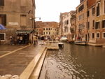
 Life along the channels
 -
 A city without car streets
 -
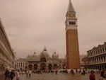 Millions of tourists visit the World Heritage City every year, Piazza San Marco
 -
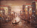
 Art or reality?
 -
 City of art


References
Agency for Prevention and Protection of Veneto region. Retrieved: December 12, 2012 from : http://www.arpa.veneto.it/acqua/htm/bacino_scolante.asp
Climate of Venice. Retrieved December 11, 2012 from the Italy-trip Website at: http://venice.italy-trip.org/climate-venice.html
CWPPRA, Coastal Wetlands Planning Protection and Restoration Act Program, USGS National Wetlands Research center, Louisiana; retrieved January 3, 2013 from : http://www.lacoast.gov/new/About/Default.aspx
Ersa - Agenzia Regionale per lo sviluppo rurale. Regional Agency for rural development. Retrieved tematic maps and data, 20 December, 2012. from http://www.ersa.fvg.it
Flood Preparedness , CDEMA, retrieved January 4, 2013. http://weready.org/flood/index.php?option=com_content&view=article&id=28&Itemid=29
Knight C., Venice floods attributed to climate change. Los Angeles Times, 2012. Retrieved December 11, 2012 from The Los Angeles Times Website at: http://www.latimes.com/entertainment/arts/culture/la-et-cm-climate-change-venice-floods-20121113,0,3592602.story
Le percentuali di allagamento. Retrieved December 17, 2012 from the City of Venice Website at: http://www.comune.venezia.it/flex/cm/pages/ServeBLOB.php/L/IT/IDPagina/1754
Mary E. Kentula, Wetlands Research Program, retrieved January 3, 2013 from : http://water.usgs.gov/nwsum/WSP2425/restoration.html
Merali Z., Saving Venice. An ambitious plan seeks to prevent a modern Atlantis. Scientific American, 2002. Retrieved December 12, 2012 from The Scientific American Website at: http://www.scientificamerican.com/article.cfm?id=saving-venice
Mitigation of Flood, BIHAR STATE DISASTER MANAGEMENT AUTHORITY , http://bsdma.org/index.php?option=com_content&view=article&id=164&Itemid=301
Morigi M.,La Carta Dell'uso del Suolo Storica e lo Studio Diacronico delle Dinamiche Territoriali, IUAV Venezia http://www.comune.calcinato.bs.it/allegati/588%5EALLEGATO%20II.pdf
Practice sustainable tourism in Venice. Retrieved December 29, 2012 from Italy culture, travel, food and apartments, hotels and news Website at: http://veniceapartments.blogspot.com/2011/02/practice-sustainable-tourism-in-venice.html
Schmetzer U., A Venetian Riddle, 2012. Retrieved January 10, 2012 from: http://www.uli-schmetzer.com/venice-mose-nomose-costa-cruise.html
Sink or Swim: Three projects on the future of Venice. Retrieved: January 10, 2013 from: http://avblivinglandscape.wordpress.com/3rd-year-work/third-year-student-projects-2011-p6/sink-or-swim-three-projects-on-the-future-of-venice/
Sustainable Tourism. Retrieved December 12, 2012 from The Context Travel Website at: http://www.contexttravel.com/special-programs/sustainable-tourism
Sustainable Venice. Retrieved December 29, 2012 from Venice>connected Website at: http://www.veniceconnected.com/sustainable-tourism
Tat F., The changing tides of Venice Future scenarios of the world’s touristed city, dissertation at the NHTV University of Professional Education, 2007. Retrieved December 29, 2012 at: http://www.tourism-master.nl/theses/TDM_thesis-Fabio_Tat_2007.pdf
Zane U., Citta di Venezia. Retrieved December 12, 2012 from http://www.comune.venezia.it
Wikipedia, Estuary, December 2012., retrieved January 3, 2013 from http://en.wikipedia.org/wiki/Estuary
About categories: You can add more categories with this tag: "", add your categories
{{#widget:WidgetName|param1=value1|param2=value2}}