Group B - Collaborative Climate Adaption Project
| Area | Lagos | |
| Place | Ajegunle | |
| Country | Nigeria | |
| Topic | please enter the topic here | |
| Author(s) | Kinga Janossy, Melissa Abas and Fadera Williams | |

| ||
|
| ||
Rationale: Why we have selected this case study area
- Climate change is now generally recognized as the greatest challenge to sustainable development, especially in a developing country such as Nigeria. Lagos State is particularly vulnerable to the impacts of climate change and unless concerted and urgent action is taken, it could result in widespread ecosystem degradation, thus disrupting socio-economic development and the welfare of the people. (Towards a Lagos State Climate Change Adaptation Strategy, January 2012)
- In Lagos State, impoverished coastal communities living on reclaimed land are at risk from flooding due to storm surges and heavy rainfall events. Residents in these communities cope with impacts such as property damage, temporary homelessness, and spread of malaria. In this case, future vulnerability will be affected by rising sea levels and increased severity of storms expected in a changing climate, which will significantly affect urban development patterns.(Source: Adelekan, 2009)
Authors' perspectives
- What theoretical or professional perspective do you bring to the case study?
Landscape and/or urban context
- Biogeography, land use patterns, cultural features, overall character, history and dynamics
- ratio of green/blue and sealed/built-up areas
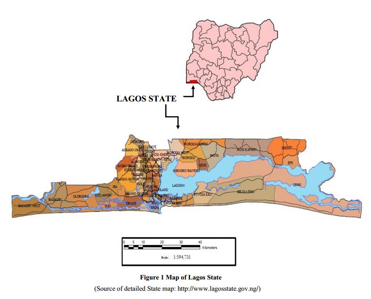
The study is set in Ajegunle which is located in Ajeromi Ifelodun Local Government Area of Lagos state Nigeria. The site is a major informal settlement, often described as ‘jungle city’ with a multi-ethnic population. It is the most populated slum in Lagos State. Ajegunle has a population density of 750 the highest of all slums in Lagos state. The slum area of Ajegunle constitutes 12.8% of the total area of all 42 blighted areas as at 1995. According to Stoveland Consult, WTP Study of 1997, majority of the multi-ethnic population of Ajegunle are of school age and highly, economically productive. Ajegunle is made up of five resident communities, and consist of people from all parts of the country with the dominant groups being the Ijaw, Ilaje, Hausa, Ibo, Urhobo and Yoruba ethnicity. Their main occupation is trading in the formal and informal sectors.
It is evident that decent housing is a major problem of informal settlement dwellers. This is largely due to their low level of financial capacity coupled with inefficient land administration system which have further exclude them from urban life and increased their vulnerability to eviction, disaster and environmental health problem. Therefore, any attempt to achieve livable, healthy and prosper cities must as a matter of urgency address housing issue. This means that there must be a conscious effort focusing on provision of decent housing for the poor at an affordable rate.
Over 70% of the buildings in the area are Brazilian type while 13.1% of the buildings in Ajegunle are traditional compound type and 9.2% are flat. It is not surprising that most of the building are Brazilian (face me and face you) buildings or rooming apartment because it is believed to be the main design and characteristics of low income group as well as poor communities in Nigeria cities. Most of the buildings (50.3%) are predominantly residential however, a significant proportion representing 40.5% of the buildings are mixed use while other land uses account for 9.2%.
About 85.9% of the buildings are accessible by roads but, the main problem is that majority of the roads are not tarred and the conditions are extremely poor. The roads are characterized by poor drainage, lack of street lighting, absence of pedestrian walkway as well as on street parking. Also some of the roads are used as refuse dump site.
Aptly named, the Dustbin Estate is a collection of shanties on refuse dump where a very poor set of people live in Ajegunle. Living on a large heap of rubbish poses a myriad of health hazards to both adults and the children, not neglecting the attendant environmental issues. Whenever there is rainfall, the situation is worsened as the entire ‘estate’ is soaked in flood and people still go about their normal duties in this deplorable state! One wonders how these people survive; they eat, drink, have their bath, sleep, talk and do virtually everything in this ever-smelly settlement. Some of them make money from charging people who dispose their refuse here, but one wonders if the 50 Naira note collected for each pack of refuse could ever sum up to justify and alleviate the prevalent abject poverty and hazardous living.
Illustration:
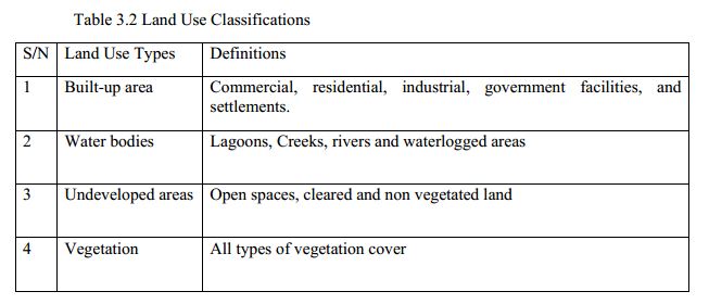
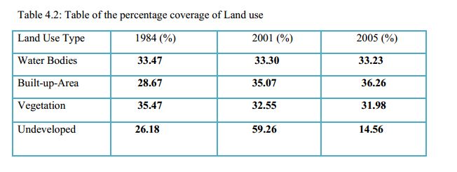
(tables from Land Use Change Analyses in Lagos State From 1984 to 2005 / Oludayo Emmanuel ABIODUN, James Bolarinwa OLALEYE, Andrew Nnamdi DOKAI and Adedayo Kazeem ODUNAIYA, Nigeria)
Map; sketches; short descriptive analyses
Cultural/social/political context
- Brief explanation of culture, political economy, legal framework
Illustration:
Bullet points, image, background notes
Local Climate
- What are the climatic conditions at present? Have there been extreme weather events in the near past?
- Which changes are expected? Is there any evidence?
Illustration: Table or time line
Analysis of vulnerability
- If you consider these potential changes - which aspects/functions of your case study would be affected?
Illustration: Map/diagram/sketches/photos/background notes
Proposals for Climate Change Adaption
- How could your case study area become more resilient to climate change?
- Which measures would need to be taken to adapt to the new situation?
- How could you assure sustainability of these measures?
- Please describe 2-3 measures
Proposals for Climate Change Mitigation
- Which measures would need to be taken to reduce greenhouse gas emissions and other drivers of climate change within your case study area?
- How could you assure sustainability of these measures?
- Please describe 2-3 measures
Your scenario
- How will this area look like in 2060?
- Please forecast one potential future development taking climate change into account
Illustration: Map/diagram/sketches photos and background notes
What can be generalized from this case study?
- Are there any important theoretical insights?
- Which research questions does it generate?
- Short statement plus background notes
Image Gallery
- Yourimage.jpg
your image text
- Yourimage.jpg
your image text
- Yourimage.jpg
your image text
- Yourimage.jpg
your image text
- Yourimage.jpg
your image text
- Yourimage.jpg
your image text
- Yourimage.jpg
your image text
- Yourimage.jpg
your image text
References
Please add literature, documentations and weblinks
About categories: You can add more categories with this tag: "", add your categories


