Rural-scape on the Fringe of City
---> back to overview of Case Study List
add long title of your theme
| Name | Village Kullupani | |
| Location | Dehradun | |
| Country | India | |
| Authors | Archana Bais | |

| ||
| <<googlemap version="0.9" lat="30.351546" lon="77.963877" zoom="15" width="300" height="250">
http:// </googlemap> </googlemap> | ||
Short Introduction to the Area of Study
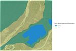
The site is located in the North of India, at the foothills of Himalayas. It’s a small village (25 families and 150 inhabitants) which is sandwiched between a reserve forest and a growing city (Dehradun).
I chose this area for this seminar as it is my thesis site. Currently because of eccentric developments of cities, villages, especially those which are on the fringes are facing lots of challenges and development pressures. My effort would be in providing direction to the transformation (with community participation) which should result in a sustainable, self sufficient and economically viable model. So far I have conducted three public meetings in which I organized workshops to help the villagers appreciate the landscape around them. A particular meeting focussed on landscape needs analysis allowed me to develop a fresh perspective on the topic.
Exercise 1: Sketching the Landscape
Time frame: October 25 - November 15, 2011
Student activities:
- Creation of analytical drawings and sketches
- Presentation of results
Please upload a selection of your drawings/sketches/mental maps and add them to the image gallery
Sketches and Drawings
-
 (Black and White Sketch of Village approach road)
 -
 (Highlighting human intervention in landscape (void))
 -
 (Highlighting landscape (mass))
 -
 (Sketch reflecting the effect of urbanization in village due to its proximity to city. Its showing the transformation in construction.)
 -
 (This sketch is depicting the usage of a particular space in village by different usergroup during the entire day )


Exercise 2: Landscape Layers
Time frame: November 15 - 29, 2011
- time based changes and 'landscape biography', and/or:
- topography, open spaces, built, green, traffic and water structures on different layers. *Definition of zones with coherent character
- Description of this character.
-
 This map represent 3 dimensional human intervention in this landscape.
 -
 This map reflects the immediate perception of current usage. specifically how the area is currently use in spite of its ownership and defined landuse.
 -
 This map shows the immediate surrounding of site under study.
 -
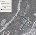
 This map shows the network of different types of commuting roads and paths (both formal and informal ones)
 -
 Shows the highest, lowest and slope of site and surroundins


Please publish your findings here
Exercise 3: Behaviour Patterns
Time frame: December 6 - 20, 2011
- How do people behave in this area? How do they use the space? What is important for them?
- Observation of study area, interviews with local people and mapping of use patterns.
There are already several personal interviews and public meetings conducted so far by me. Interesting thing is because of proximity to the city and forest, young generation is giving up on agriculture. So most of the agriculture land is lying unused and undefined. There is no public space as such for different user group. Only area which comes under religious use having temple is being used by different user group at different time of day. It is interesting to see that there is no formal discussion on how and when different groups should use the area, there is a common understanding between the villagers which avoids conflicts between different user groups. It is sad to see that once developed just because of agriculture reasons, now there are only few people in their fifties or sixties who are doing farming. There are very many reasons for that which I would like to discuss more for my further studies.
- Preparation of short presentation
-
 This map shows the usage of same area by different user groups during the day
 -
 This map shows movement pattern by different user group
 -
your image text
-
your image text
-
your image text


Please publish your findings here
Exercise 4: Communication Concepts
Time frame: December 19, 2011 - January 17, 2012
- Based on the different landscape assessment approaches students will develop a communication concept for their area of study
- Which measures would be necessary for enhancing the awareness for the area?
- Students are free to choose their method.
-
your image text
-
your image text
-
your image text
-
your image text
-
your image text
Please publish your findings here
Image Gallery
-
your image text
-
your image text
-
your image text
-
your image text
-
your image text
References
* Please make sure that you give proper references of all external resources used.
* Do not use images of which you do not hold the copyright.
* Please add internet links to other resources if necessary.
About categories: You can add more categories with this tag: "", add your categories