File:1 analyse area green water topo.jpg
Jump to navigation
Jump to search

Size of this preview: 566 × 599 pixels. Other resolution: 1,000 × 1,059 pixels.
Original file (1,000 × 1,059 pixels, file size: 986 KB, MIME type: image/jpeg)
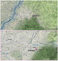
The case study area is located east of Karlsruhe at the output of the Pfinztal, which is a municipality in the district Karlsruhe, and has to its west lies the Rhine valley, to the north the Kraichgau and to the south the northern border of the Black Forest.
File history
Click on a date/time to view the file as it appeared at that time.
| Date/Time | Thumbnail | Dimensions | User | Comment | |
|---|---|---|---|---|---|
| current | 19:58, 28 November 2011 |  | 1,000 × 1,059 (986 KB) | Kanako Tada (talk | contribs) | |
| 17:31, 28 November 2011 |  | 1,000 × 1,051 (975 KB) | Kanako Tada (talk | contribs) | ||
| 17:30, 28 November 2011 |  | 1,200 × 1,261 (1.32 MB) | Kanako Tada (talk | contribs) |
You cannot overwrite this file.
File usage
The following page uses this file: