Overpass Landscapes
---> back to overview of Case Study List
add long title of your theme
| Name | Overpass from Dresden Hauptbahnhof to Neustadt bahnhof | |
| Location | Dresden | |
| Country | Germany | |
| Authors | Natalia Kita and Dragana Romic | |

| ||
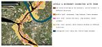
| <googlemap version="0.9" lat="51.055747" lon="13.744926" zoom="13" width="300" height="300">
51.040584, 13.73188 Dresden Hauptbahnhof 51.065511, 13.739862 Dresden Neustadt bahnhof </googlemap> | ||
Short Introduction to the Area of Study
Overpasses are important as a transport structures, but also as elements of everyday landscape which thousansd of people pass on their way.
Dresden’s railway overpass is located in the western part from the city center and connects 3 train stations: Dresden Neustadt, Dresden Mitte and Dresden Hauptbahnhof. Points where overpass cut the streets, space under and it’s surrounding lie in area of our biggest interest. It’a place where pedestrian, cyclists, people going by car and train meet for short moment, to continue travel to their destination.
These places usually exist in people’s minds as not pleasant for the eye structure, sometimes dirty and scary which they need to just go through to get on the other side, in reality the usage and meaning of it, can be much more sophisticated. Overpasses create landscape windows, they can be background, foreground, accent or cover to different spaces.
Exercise 1: Sketching the Landscape
Time frame: October 25 - November 15, 2011
Student activities:
- Creation of analytical drawings and sketches
- Presentation of results
Please upload a selection of your drawings/sketches/mental maps and add them to the image gallery
Sketches and Drawings
-
 Similarity beetwen the shapes of two important city flows
 -
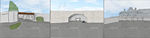
 Comparing focuses- Neustadt-stucture in focus, Mitte- frame in focus, Hauptbahnhof-background in focus
 -
 Comparing movements -Neustadt, Mitte and Hauptbahnhof using the typology of colours
 -
 Comparing light -Neustadt, Mitte and Hauptbahnhof using the typology of light
 -
 Comparing textures- Neustadt, Mitte and Hauptbahnhof with different dominant surfaces

Exercise 2: Landscape Layers
Time frame: November 15 - 29, 2011
- time based changes and 'landscape biography', and/or:
- topography, open spaces, built, green, traffic and water structures on different layers. *Definition of zones with coherent character
- Description of this character.
-
 Land use map shows different funcional areas that are important in the city and influenced by Dresden's railway
 -
 Character of place and human habits map shows how do people percive different places in the wider area of Dresden’s railway influence
 -
 Historical map that shows the development of this area in the begining of XX century
 -
 Historical map that shows the areas of destruction in the mid XX century
 -
 Map that shows different levels in vertical city structure and movement connected with this levels


Please publish your findings here
Exercise 3: Behaviour Patterns
Time frame: December 6 - 20, 2011
- How do people behave in this area? How do they use the space? What is important for them?
- Observation of study area, interviews with local people and mapping of use patterns.
- Preparation of short presentation
Please publish your findings here
Exercise 4: Communication Concepts
Time frame: December 19, 2011 - January 17, 2012
- Based on the different landscape assessment approaches students will develop a communication concept for their area of study
- Which measures would be necessary for enhancing the awareness for the area?
- Students are free to choose their method.
Please publish your findings here
Image Gallery
-
your image text
-
your image text
-
your image text
-
your image text
-
your image text
References
* Please make sure that you give proper references of all external resources used.
* Do not use images of which you do not hold the copyright.
* Please add internet links to other resources if necessary.
About categories: You can add more categories with this tag: "", add your categories