Pictures of our Landscapes BIOS Group 1
---> Back to overview of groups
Cecilia Curbelo, Rafael Dodera and María Teresa Hampe
Images
-
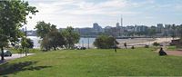 Park Rodo Coastline Montevideo
 -
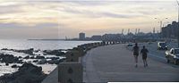 Coastline South Montevideo
 -
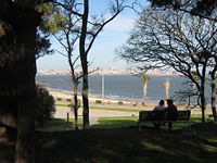 Cerro Coastline Montevideo


Description
The city of our University, Montevideo, is situated on the south coast of Uruguay on the River of the Plate. Its climate is temperate, but the predominantly gently undulating geography makes our countryside vulnerable to rapid changes from weather fronts. The foundation of the city dates from 1725 and was founded as a strategic move between a Spanish-Portuguese dispute over the Viceroyalty of the Río de la Plata. As most of the pre-Columbian inhabitants have been defeated, the generality of the residents of the country descends from European immigrants. Currently Montevideo has about 1.4 million inhabitants. What most distinguishes our city in Uruguay is its 30 km coastline, besides the bay and the seaport. This coastal strip delineates the space of the "sea" Río de la Plata with its changing nature with the urbanized space. The 22 km long avenue along the coast, “rambla”, created for mobility, gives our city a constant in its appearance. On one side the rocks and the beaches, the sea has its limit on the skyline with the sky as a continuous line, on the other side of the rambla different types of edifications, parks and squares show the mark of human actions. The pictures show three views of our coastal strip, where you can always see the main city in the ground: In the front of the first is an urban park, which was created on dunes of sand at the beginning of the twenties siècle. Its artificial vegetation is almost exotic, but you can find also some indigenous specimen, responding to recent ecological requests of our countryman. This part of the rambla is the most visited all over the year, because of its urban and geographic location, protected of the wind. In summer its beach is used for bathing and swimming. In the second picture dominates the urban shape with its strip itself. This kind of wall suffers with the inclement and storms: With its foundations on the rocks next to the sea it has to be repaired form time to time. In the back you see the cranes of the seaport, and on your left the other coast of our bay. The third picture is taken from a large suburban park on the other side of our bay. Although this side has a beautiful view on the bay and the main city, it is visited by a restricted part of our population: great part of the poor population of Montevideo lives on this side of the bay. Depending of climate the seaside will change its scenery: when polar air masses move from the south and the waves moisten the avenue, only birds and a few fishermen will visit the rambla. But with temperate climate, people arrive from everywhere to carry out activities of entertainment, recreation, sports, jogging or meeting. The rambla is a democratic space in our city, where everyone takes part without differentiation of ages, social classes, cultural or religious ideas. Above all the rambla is an area of social identity.