Unused files
Jump to navigation
Jump to search
The following files exist but are not embedded in any page. Please note that other websites may link to a file with a direct URL, and so may still be listed here despite being in active use.
Showing below up to 50 results in range #901 to #950.
-
 Herredsvang Slide1.jpg 960 × 720; 114 KB
-
 Herredsvang Slide3.jpg 960 × 720; 136 KB
-
 Folie11.JPG 960 × 720; 57 KB
-
 Folie22.JPG 960 × 720; 88 KB
-
 Folie33.JPG 960 × 720; 52 KB
-
 Folie44.JPG 960 × 720; 139 KB
-
 Kasselpark1.JPG 960 × 720; 57 KB
-
 12345.JPG 960 × 720; 57 KB
-
 Kassel 1 (1).JPG 960 × 720; 88 KB
-
 Marienlyst Parken seen from the bottom of Kommodsbakken.jpg 4,320 × 3,240; 5.59 MB
-
 Smooth Topography on Kommodsbakken.jpg 4,320 × 3,240; 5.5 MB
-
Signature Slogan in 'Ã…rhus Ghetto' on top of Kommodsbakken.jpg 4,320 × 3,240; 5.52 MB
-
 Tuesday Lunch-time Jogger on Kommodsbakken.jpg 4,320 × 3,240; 5.64 MB
-
 Kommodsbakken.jpg 4,320 × 3,240; 5.48 MB
-
 View from Kommodsbakken towards the Residential Area (1).jpg 4,320 × 3,240; 4.9 MB
-
 View from Kommodsbakken towards the Residential Area (2).jpg 4,320 × 3,240; 5.13 MB
-
Signature Slogan in 'Ã…rhus Ghetto' on top of Kornmodsbakken.jpg 4,320 × 3,240; 5.52 MB
-
View towards HelligÃ¥ndskirken.jpg 4,320 × 3,240; 5.05 MB
-
 Containers.jpg 843 × 600; 147 KB
-
 Herredsvang Slide2.jpg 960 × 720; 146 KB
-
 Herredsvang Slide0.jpg 960 × 720; 195 KB
-
 Idea (creative (s)p(l)ace).jpg 699 × 594; 73 KB
-
 P1.JPG 803 × 602; 50 KB
-
 P2.JPG 801 × 604; 106 KB
-
 P3.JPG 803 × 601; 90 KB
-
 Banska stiavnica.jpg 500 × 375; 184 KB
-
 Huge map s.jpg 1,628 × 175; 65 KB
-
 New Assignment 2.png 1,999 × 882; 166 KB
-
 Concept Map Final.jpg 2,909 × 1,733; 1.35 MB
-
 Urban Adaptation Planning.jpeg 2,909 × 1,735; 1.35 MB
-
 Maldives001.jpg 960 × 643; 204 KB
-
 Delhi flood.jpg 420 × 314; 62 KB
-
 2 (1).jpg 610 × 458; 101 KB
-
 Venice 1.jpg 610 × 383; 142 KB
-
 Venice 1.png 610 × 383; 287 KB
-
 Tsra.gv.au Iama Island.jpg 276 × 185; 13 KB
-
 Annika torres-strait-map11.png 3,054 × 1,934; 924 KB
-
 NewClimatechangerisk.jpg 500 × 375; 47 KB
-
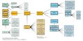 Miguel ConceptMap Reinke.jpeg 8,268 × 4,134; 1.38 MB
-
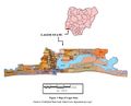 Lagos state.JPG 762 × 613; 57 KB
-
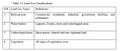 Classifications.JPG 653 × 280; 37 KB
-
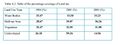 Percentage.JPG 652 × 245; 33 KB
-
 Rivers.gif 750 × 420; 41 KB
-
 Tundra.gif 300 × 305; 26 KB
-
 Barrow.jpg 726 × 552; 70 KB
-
 Lagoon.png 1,902 × 900; 1.08 MB
-
 Ajegunle.jpg 2,200 × 1,056; 1.13 MB
-
 Tegucigalpa satellite image .jpg 1,000 × 730; 446 KB
-
 Tegucigalpa downton 1.58 km.jpg 1,000 × 730; 412 KB
-
 Dhaka rickshaws.jpg 194 × 174; 23 KB


.JPG)


.jpg)
.jpg)


p(l)ace).jpg)


.jpg)


