Collaborative Green Infrastructure Design Group D
---> back to group page working group D
Please add the title of your case study here, adjust the map coordinates and replace the moa image with a characteristic image of your site
| Name | Conversion zone: Former US military territories/US Hospital | |||||||||||
| Location | add location | |||||||||||
| Country | Germany | |||||||||||
| Authors | Erika Jureviciute, Marklen Nakuci, Teodora Koos-Morar, Tabea Crecelius | |||||||||||

| ||||||||||||
| {{#widget:GoogleMaps | width=300 | height=200 | lat=49.3753785 | lng=8.6840666 | zoom=14 | centermarker=yes | maptypecontrol=yes | overviewmapcontrol=yes | largemapcontrol=yes | scalecontrol=yes
}} | ||
Landscape and/or urban context of your case
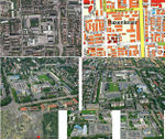
Heidelberg is a town situated on the River Neckar in south-west Germany. The fifth-largest town in the State of Baden-Württemberg after Stuttgart, Karlsruhe, Mannheim and Freiburg im Breisgau, Heidelberg is part of the densely populated Rhine-Neckar Metropolitan Region. Heidelberg is in the Rhine Rift Valley, on the left bank of the lower part of the River Neckar in a steep valley in the Odenwald. It is bordered by the Königsstuhl (568 m) and the Gaisberg (375 m) mountains. The River Neckar here flows in an east-west direction. Since Heidelberg is among the warmest regions of Germany, plants atypical of the central-European climate flourish there, including almond and fig trees; there is also an olive tree in Gaisbergstraße.
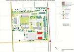
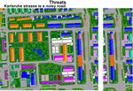
The US Hospital is located in the south of Rohrbach at the Karlsruhe street. It was the hospital for the army people and their families living in Heidelberg, Mannheim, Worms and Karlsruhe. The US Hospital is the smallest conversion area in Heidelberg for redevelopment having only 1,8 ha built up. The basic structure and functionallity of the buildings are mostly directed with the hospital operations. Two buildings on the east, the former sporthall and theater are buildings to be conserved. The area is very easilly accessible with the individual and public transport. Currently the area is accessible from Karlsruhe, Freiburger and Kolbenzeil streets.
- Maps
-
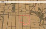 1907
1907 -
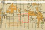 1937
1937 -
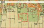 1939
1939 -
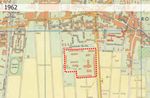 1962
1962 -
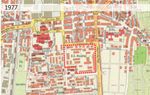 1977
1977 -
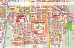 2002
2002


What are the overall objectives of your design? What are the specific objectives for enhancing green infrastrucutre?
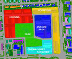
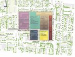
Currently the area is a dead zone. Nobody is allowed to enter in it. The buildings are in bad shape needing demolition and improvement interventions. Considering these issues, the main objective is to turn the area in a vital zone that will serve the city and its residents. The interventions and the changes should be done according Green Infrastructure principles. Therefore connectivity, multi-functionality and sustainability are the 3 main goals. New roads will penetrate the zone in order to connect and integrate it with the city. Thus this zone will not be anymore an island in the city but will be part of it. The area contains historic values that need to be retained and reinforced. To keep the cultural heritage of this areas we propose to transform one of the buildings into a museum and some of the buildings will be adapted to contain new functions. Functions like dormitory, housing, cinema, sport facilities, museum connected through green areas will characterize the zone in order to fulfill the multi-functionality aspect of Green Infrastructure. The green spaces and the park that we propose in the zone will create a sustainable environment.
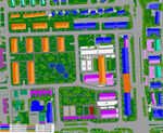
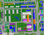
Analytical drawings
Please add four analytical sketches/drawings (or montages/schemes) of your case. Every group member needs to contribute at least one drawing.
- Analytical Drawings
-
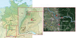 Location within Germany Tabea Crecelius
 -
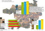 Statistics Heidelberg Tabea Crecelius.jpg
 -
 Analytical drawing Teodora Koos-Morar
 -
 Analytical drawing Marklen_Nakuci
 -
 Analytical drawing Marklen_Nakuci
 -
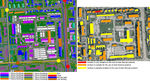
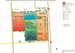
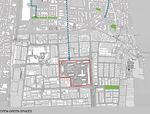 Open green spaces
 -
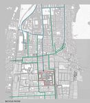 Bicycle routes
 -
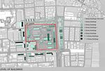 Building levels
 -
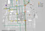 Transportation infrastructure


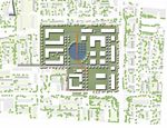
Projective drawings
Please add four projective sketches/drawings (or montages/schemes), of course with an emphasis on green infrastructure aspects. Every group member needs to contribute at least one drawing representing his/her individual ideas.
- Projective Drawings
-
 Projective drawing Marklen_Nakuci
 -
 Projective drawing Marklen_Nakuci
 -
 Projective drawing Marklen_Nakuci
 -
 Projective drawing Teodora Koos-Morar
 -
 Projective drawing_Erika
 -
 projective drawing_Erika


Design Synthesis
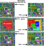
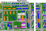
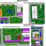
Please analyse the individual approaches presented so far and evaluate their strengths and weaknesses (you may use the SWOTanalysis model). Try to create a synthesis and represent it with a plan and some sketches. You can still use drawings/sketches.
- Design Synthesis Drawings
-
 synthesis drawing SWOT_Marklen_Nakuci
 -
 synthesis drawing SWOT_Marklen_Nakuci
 -
 synthesis drawing SWOT_Marklen_Nakuci
 -
 synthesis drawing SWOT_Marklen_Nakuci
 -
synthesis drawing 2
-
synthesis drawing 3
-
synthesis drawing 4


Summary of the collaborative process
Please reflect on your collaborative design process. Which potentials have you encountered? What was most difficult? What does collaborative design mean for you? (approx 150 words).
Image Gallery
You may add a series of images/photos in addition to the sketches/drawings
- Image Gallery
-
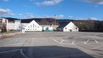 image 1
 -
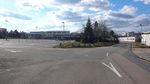 image 2
 -
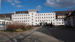 image 3
 -
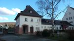 image 4
 -
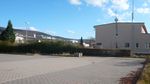 image 4
 -
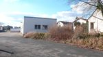 image 4
 -
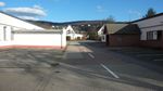 image 4
 -
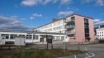 image 4
 -
image 4


References
* Please make sure that you give proper references of all external resources used.
* Do not use images of which you do not hold the copyright.
* Please add internet links to other resources if necessary.
http://www.heidelberg.de/Konversion,Lde/Startseite+Konversion/Konversionsflaechen.html http://en.wikipedia.org/wiki/Heidelberg http://www.heidelberg.de/site/Heidelberg_ROOT/get/documents/heidelberg/Objektdatenbank/12/PDF/12_pdf_Heidelberg_auf_einen_Blick.pdf
About categories: You can add more categories with this tag: "", add your categories