Case Study Clemson 2
---> back to overview of Future Landscapes Group 2
Geos Net-Zero Energy Use Community by Beyza, Elise, Susannah, Vineet and Ginny
| Name | Geos | |
| Location | Arvada, Colorado | |
| Country | USA | |
| Office | Geos Developers, Michael Tavel Architects and
David Kahn Studio Landscape Architecture and Urban Planning | |
| Client | Norbert Klebl | |
| Completion | Phase One to be completed 2010, Phases Two and Three by 2012 | |
[[
| ||
| <googlemap version="0.9" lat="-23.581609" lon="-46.590271" type="satellite" zoom="9" width="300" height="250">
</googlemap> | ||
Core Question 1: In how far does this project reveal your concept of future landscapes?
On August 13, 2003 New York City went dark. Cities all along the eastern United States coast experienced the same problem, a blackout. A series of chance events beginning with the shut down of an energy plant in Ohio, a state in the upper mid-western part of the country, ended in a blackout ranging from Baltimore, Maryland all the way into Canada. The outdated electric grid was to blame (http://www.aip.org/tip/INPHFA/vol-9/iss-5/p8.html).
Geos, a new development in Arvada, Colorado, aims to be the United States’ first net-zero energy use community. This small community will make an enormous contribution to the outdated energy grid – it will provide housing while giving the grid a rest, and a boost. Upon the completion and the anticipated success of this community, it will serve as a model for future developments hoping to eliminate dependency on a power grid that will not be able to support much more American suburban sprawl.
Landscape and/or urban context
- Biogeography, cultural features, overall character, history and dynamics
The site was strategically selected with an emphasis on being close enough to shopping, bike trails and public transportation to significantly reduce residents' automobile use. It is 20 minutes from downtown Denver and 20 minutes from Boulder in Arvada, CO.
Project data below from the ASLA Professional Awards Site:
Total Acreage: 25.2 acres
Number of Residential Units: 282
Net Density: 23.2 Dwelling Units/Acre
Commercial Square Footage: 12,000 sf — neighborhood service oriented
Civic Buildings: CoHousing Community House on Central Square
Parks & Open Space: 8.5 acres 34% of site includes: Percolation Parks with fruit tree co-ops, gardens, play areas. Town Squares with civic amenities, play grounds, event spaces. Mixed Use Meadow with native habitat, active & passive use areas, and agriculture. Energy Systems: 1.3 Megawatt PV System; 5,000,000 BTU Geothermal System CARBON FREE — NO FOSSIL FUELS
Process: 2004–2007 Development Plan and Sustainable Mixed Use Design Code Completed. 2007 Planning Commission and City Council Approval 2008 Planning Staff Approval of Construction Documents 2009–2010 Phase 1 Construction. 2010–2012 Phase 2 and 3 Construction.
LEED Status: Qualifies for LEED-ND (Neighborhood Design) at Silver Level.
Cultural/social/political context
- Brief explanation of culture, political economy, legal framework
The area surrounding Denver, Colorado is a unique mix of small towns, large cities, industry and majestic mountains. Geos is uniquely situated to be close to the urban core of downtown Denver, the hip, progressive and funky town of Boulder, next to Golden, home of the Coors brewery and less than a half hour from the majestic Rocky Mountains. Three distinctly different places, Golden with its industry, Boulder with its reputation for being environmentally conscientious and Denver being one of the largest cities in the western United States each offer opportunities for Geos residents.
Spatial analysis of area/project/plan
- What are the main structural features?
Geos is bordered by the Croke Canal on the western side and Ralston Creek on the southern side, in a very small scale the neighborhood is contained by a natural boundary (the creek) and a manmade boundary (the canal).
In the 25 acre parcel, there are four distinct districts. The 'Entry' area mixes ground level retail with apartments and townhomes at the entrance to the community. This main street district has the most affordable housing. The 'Checkerboard' neighborhood mixes single family attached and single family detached homes. The 'Garden' neighborhood is comprised of single family attached housing with private patios and gardens. Finally, the 'Beachfront' neighborhood, named for the adjacent meadow to the south nicknamed 'The Beach', is a mixed use neighborhood with restaurants, shops and housing.
- How has it been shaped? Were there any critical decisions?
While the western and southern boundaries of the development were defined by water, the eastern and northern portions are defined by something ubiquitous with western US planning – the Cartesian grid property lines. Inside the property, the plan follows a grid pattern ensuring both permeability and maximum solar energy production.
Analysis of program/function
- What are the main functional characteristics?
Reduce the dependency on fossil fuels to alleviate the pressures on the over-extended, out-dated US power grid
Treat stormwater
Maintain high level of open space
Promote agriculture at many scales
- How have they been expressed or incorporated?
Use of geo-thermal energy fields for heating and cooling
Place houses in east west orientation for greatest solar power generation
Solar panels for electricity generation, this area gets an average of 300 sunny days, excellent for solar energy capture
Rain gardens and percolation parks
34% of the development is dedicated green space
Community gardens, orchards and fruit tree terraces contribute to neighborhood food production and agricultural stewardship
Analysis of design/planning process
- How was the area/project/plan formulated and implemented?
The project and plan were formulated by a multidisciplinary team, with David Kahn Studio (landscape architecture and urban design) heading up the design and planning process. According to David Kahn Studio, at the planning level many different street-building layouts were analyzed to ensure the maximum harvest/conserve energy ratio, that is they would like to maximize the energy harvest and the energy conservation, striking a balance that helps the community achieve its goal of being a net zero energy consuming neighborhood.
- Were there any important consultations/collaborations?
This project was the result of a winning team of developers, architects, landscape architects, builders and engineers. Each group brings specific knowledge pertaining to the project and to the ultimate goal of creating the first net zero energy use community in the US.
Analysis of use/users
- How is the area/project/plan used and by whom?
The project will be comprised of 282 homes with five different types of residential types: single family, live/work condos, townhomes/stacked flats, apartment homes and mixed use residential (retail beneath apartments/flats). This combination allows for a variety of uses and a broad socioeconomic range of residents.
- Is the use changing? Are there any issues?
As a green field development, yes, the use is changing. Currently open space in between other suburban neighborhoods, this development offers higher density housing for Arvada, Colordado, a welcome change to the low density suburban sprawl that is currently surrounding the Geos site.
Core Question 2: What is the role of landscape architecture in this project?
Michael Kahn Studios received 2009 National Honor Award for Analysis and Planning from the American Society of Landscape Architects. award for this design. With close to 40% of the 25 acres preserved as green space, Geos will serve as an excellent model for future developments, not only for the fact that it is a net zero energy use community, but that it preserves, maintains, and places a high importance on open space.
Additional Awards: Colorado AIA Citation Award for Sustainable Planning, 2006 Denver AIA Honor Award, 2006 Denver AIA Sustainability Award, 2006
You may add 1-2 more core questions as discussed in your group
Image Gallery
-
 Master plan
 -
 Homes surrounding a percolation park
 -
 Homes at the edge of a geo-thermal field
 -
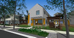 A home in the checkerboard neighborhood
 -
 Solar panels will make good use of the 300+ sunny days


References
http://www.aip.org/tip/INPHFA/vol-9/iss-5/p8.html
http://discovergeos.com/geo_solar.php
http://www.asla.org/2009awards/462.html
About categories: You can add more categories with this tag: "", add your categories