Pictures of our Landscapes BIOS Group 2
---> Back to overview of groups
Authors:ADRIANA BABINO+LUIS CONTENTI+CARINA NALERIO
Images
-
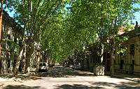 Landscape scale street daily Montevideo
 -
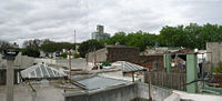 Landscape-scale roofs Montevideo
 -
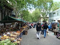 Temporary appropriation Montevideo


Description
We focus on typical neighborhoods of the central area of Montevideo, which formed since the mid-nineteenth century have remained largely unchanged until today, as determinants of the landscape of the city both in its spatial and cultural dimensions.
Features:
This area reaches its urban structure between the late nineteenth and early twentieth century. The streets, many of which reveal the horizon of the Rio de la Plata (River Plate), are characterized by the repetition of patio homes, alignments of plane-trees (platanus spp) and gray tile sidewalks edged by large pieces of pink granite.
The trees are appropriate to the climatic characteristics: its deciduous foliage allows the passage of sunlight in winter and shade in the summer months. Thus, summer foliage forms a brillant dome over shadowy streets, wich are covered in autumn by crunchy leaves.
The appropriation of landscape: Escuchar Leer fonéticamente
The streets, beyond its primary function of movement, are the support of most diverse activities that construct the identity of each neighborhood: the fruit and vegetable fairs of every week, the candombe groups that play touring the area, the street football games at weekends, and everything that makes of living in a city a collective experience.
On the other hand, a slightly elevated point of view shows a landscape radically different: the ceiling of flat roofs and skylights that illuminate the old houses. Hanging clothes, grillrooms and some plants show the multiple appropriation of these private spaces, built on a continuum that opens to the public eye, in sharp counterpoint to the clear distinction between public and private at street level.
Images: _ Street: daily _ Street: temporary appropriation _ Roof appropriation