Caulim Creek Neighborshed
Green Infrastructure for the Informal Settlement in the Watershed Area of São Paulo Metropolitan Region (Brazil)
| Name | Caulim Creek Neighborshed | |
| Place | São Paulo Metropolitan Region | |
| Country | Brazil | |
| Topic | please enter the topic here | |
| Author(s) | Thelma Hisayasu and Paulo Pellegrino | |
| Completion | Please enter the date of completion | |
| Client | Please enter the client | |
| Project costs | Please enter the costs (if known) | |

| ||
| <googlemap version="0.9" lat="-23.742612" lon="-46.483154" type="satellite" zoom="9" width="300" height="250">
</googlemap> | ||
Rationale: Why is this case study interesting?
As a case study for a pilot-project, it was chosen the Caulim Creek Neighborshed, one of the streams that is included in the State’s Water and Sanitation Company Program of Clean Streams. This case study is interesting because it can depict a proposal of landscape plan and design as green infrastructure for an area where the conflict between the urban growth and the nature preservation seems contradictory, and could explicit how environmental problems are inseparable from the economic and social realms in an emergent mega-city.
Author's perspective
Green infrastructure for informal settlement in São Paulo Watershed Area.
Green infrastructure is the network of connected open spaces where a myriad of landscape elements integrate natural processes in the urban fabric. It represents a way of taking advantage of ecological services for promoting sustainability and conservation of natural resources in the urban areas and its surrounding reg
Recordings of Online Presentation
Case study presentation on Wednesday, 14th of January 2009:
Landscape and urban context
The city of Sao Paulo is the capital city of São Paulo State, along with 38 other municipalities compose the Sao Paulo Metropolitan Region. Sao Paulo Metropolitan Region has almost 20 million inhabitants in an area of 8,000 km2. It is located on a plateau at 800 meters of height and about 70 kilometers from the sea. It has GNP of U.S. $ 171 billion, equivalent to 63% of the GNP of São Paulo State and 20% of Brazilian GNP. [1] [2]
The forested areas around Sao Paulo Metropolitan Region are part of the Biosphere Reserve of the Atlantic Forest.
The Atlantic Forest is a Hot Spot, which is one of the most biologically rich regions and also one of the most endangered of the world. The Atlantic forest occupied 1,200,000 km2, almost continuously throughout the Brazilian coast. The State of Sao Paulo had about 81% of its territory covered by Atlantic Forest. After several decades of extensive land farming activities, intense urban growth and devastation of native vegetation, now only about 3% of the State's territory is covered by forest. [1]
-
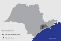 State, regional and municipal borders of São Paulo. Graphic: Pellegrino, Hisayasu. Basis: São Paulo Metrópole
 -
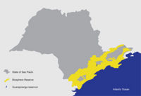 Biosphere Reserve of the Atlantic Forest. Graphic: Pellegrino, Hisayasu. Basis: A Reserva da Biosfera da Mata Atlântica no Estado de São Paulo. Serie Cadernos da Reserva da Biosfera da Mata Atlântica.
 -
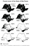 Change of forest cover in the State of São Paulo from 1854 - 2000. Source: A Reserva da Biosfera da Mata Atlântica no Estado de São Paulo. Serie Cadernos da Reserva da Biosfera da Mata Atlântica.


In the State of Sao Paulo, the Biosphere Reserve has as some of its objectives the conservation of plant and animal biodiversity, the quality of air, soil conservation and production of quality water to supply.[3]
In the Sao Paulo Metropolitan Region most of the drinking water comes from the reservoirs in the southern limits (Guarapiranga and Billings).
The proposed area of study comprises the sub-watershed of a tributary of the Caulim creek, in the administrative district of Parelheiros. Caulim Creek is one of the rivers which supply the Guarapiranga resevoir. In this tropical climate, and with hilly topography, the terrain of these settlements is unstable, prone to erosion and landslides, and the stormwater produces a continuous major impact on the water quality of the reservoir.
The Caulim Creek project area borders the environmental protection area that is still preserved . Caulim sub-watershed area is home of 20.000 people, it is a sector of 200 km2 in the watershed area [2] where is still possible to find streams not yet channelized and remaining forests patches, and where the sewage catchment system is already set. Despite the sewer system, the density and pattern of settlements in the watershed will cause flooding and water quality impacts.
-
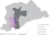 Sub-watershed Caulim in São Paulo Metopolitan Region Graphic: Pellegrino, Hisayasu. Basis: Mananciais da Região Metropolitana de São Paulo
 -
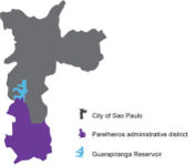 Sub-district Parelheiros in the city of São Paulo. Graphic: Pellegrino, Hisayasu. Basis: Planos Regionais Estratégicos Subprefeitura Paelheiros
 -
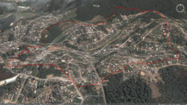
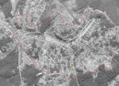
 Sub-district Parelheiros. Graphic: Pellegrino, Hisayasu. Basis: Googleearth
 -
 Sub-district Parelheiros in the city of São Paulo. Graphic: Pellegrino, Hisayasu. Basis: Googleearth


Cultural/social/political context
The watershed areas (Guarapiranga and Billings) was declared protected by law 30 years ago, not allowing conventional developments. Instead of it, since then many informal low-income settlements were built on the once-forested areas of the watersheds, decreasing the water quality and increasing the cost of water filtration and treatment. In this process of settlement, most of the forest that once covered the margins of the reservoirs lakes was changed to high density self-constructed housing among not planned streets where now lives more than 1.6 million people.[3] The public administration has now concentrated efforts to improve housing and urban infrastructure in these neighborhoods. Nevertheless, these projects follow the conventional way of building the city as a paved and build surface where the remaining vegetation is considered primarily for ornamental functions.
History
There are details of that southern city of Sao Paulo was formerly inhabited by Tupi Indians. In the twentieth century, the Guarani, a subgroup Tupi reached Parelheiros and it has set. Remnants of that core are two villages that still exist in the region, with 600 indigenous.
These two villages are located within the Area of Environmental Protection Capivari-Monos, which occupies 70% of the territory of Parelheiros. Within the Environmental Protection Area, there is also a Crater of Colony, a formation with 3.5 kilometers, caused by the impact of a celestial body on Earth, millions of years ago. After the construction of Guarapiranga Reservoir, between the years 1906 and 1912, and Billings Reservoir, in 1927, the interest in the southern city of Sao Paulo increased. The reservoirs created a potential for leisure in the region, resulting in intense property speculation around lots for construction of recreational facilities. Country houses, clubs and spas camp came to characterize large areas of the outskirts of the reservoirs.
From 1940, Parelheiros becomes an option for affordable housing for employees of industries located in neighboring districts, such as Santo Amaro. There was an intensive growth of the area built the margins of junctions of roads or pre-existing rural towns. In the decades of 1950 and 1960, the State of Sao Paulo was an intense process of industrial expansion, which resulted, among other things, the expansion of the Industrial Park of Santo Amaro, inducing urban growth toward Parelheiros. In 1975 was promulgated the The Law of Watershed Protection and the Law of industrial zoning. There was, thus, limits the deployment of new industries and control the expansion of existing ones. However, the legislation relating to water sources was insufficient to contain the advance of urbanization and environmental degradation.[4]
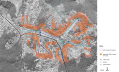
Spatial analysis of area/project/plan
-
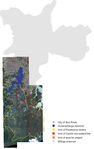
 Project area. Graphic:Pellegrino, Hisayasu. Basis: Googleearth
 -
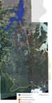
 Survey of slope. Graphic:Pellegrino, Hisayasu. Basis: Ikonos, Cesad, FAUUSP.
 -
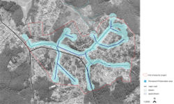 Preservation areas. Graphic:Pellegrino, Hisayasu. Basis: Ikonos, Cesad, FAUUSP.


According to the Environmental Law, is considered permanent preservation area the range of 50 meters around springs and range of 30 meters around water courses of up to 10 meters wide. On that basis, the survey of the areas of permanent preservation was made.
Core Questions Working Group Green Structure Planning
How does funding influence the planning and use of public space?
Caulim Creek is present in Stream Clean Program, launched by the Government of the State of Sao Paulo in partnership with the Mayor of the City of Sao Paulo and Environmental Sanitation Company of the State of Sao Paulo. The Program envisages the improvement of the system for collecting and cleaning of drains and urbanization of the banks of streams. In a first phase, are invested 200 million reais in 42 streams, benefiting 2.4 million people in an area of 204 km2, within two years. However, the schedule provides that 300 streams will be cleaned in a period of ten years. Caulim Creek is in the first phase of the investment Program and will receive an investment of 1.35 million reais.[4]
It is part of the guidelines of the Environmental Policy of the Sao Paulo City’s Master Plan to extend the city's vegetation cover through afforestation Programs and creating new parks, especially the linear parks along the courses of rivers and streams. [5]
The presence of the Caulim Stream in the Political Programs was crucial to the definition of the study area. Besides this study that Thelma is developing for her final paper for the School of Architecture and Urbanism, there is also a group doing a project for this area, and the result of these works will be presented to the São Paulo Environmental Sanitation Company and also to leaders of the District of Parelheiros.
How are spaces within the site used both currently and projected?
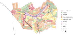
The area selected for the development of Green infrastructure project is part of the Caulim Creek Sub-Watershed, which has a population of about 20 thousand people and an area of approximately 9.62 km2.
As previously mentioned, in the watershed areas, the low-income occupation is predominant and the urban design denounces the lack of planning.

Graphic:Pellegrino, Hisayasu. Basis: Ikonos, Cesad, FAUUSP.
In the area selected for the green infrastructure project, the use of ground is mixed, predominantly low and media densities. It was high density, areas with more than 50% of the soil impervious, media density, areas with 30 to 50% of the soil impervious, and low density, areas with less than 30% of impervious soil. A municipal school and a Linear Park were recently opened.
How can the historic elements / layers be integrated?
The area has important natural and cultural values, such as the crater that was produced by a meteorite and still shows some indigenous settlements. These aspects plus the remaining Atlantic Forest that covers the hilly landscape thorough the mountain range that falls down to sea level, set the potential for the development of eco-tourism activities in the district of Parelheiros.
The presence of these significant forest cover and the water bodies, reveals the strategical importance of the region, and justify the necessary preservation of natural resources and the establishment of sustainable land uses and urban activities.
The structure of these vegetated areas also can be integrated with the other green infrastructure element, and represents an opportunity to become ecological corridors that connect the adjacent existing forests, and then helping the control of the urban sprawl and the consolidation of the greenbelt
How do the contributing elements of water relate to the project?
The waters of the Guarapiranga Reservoir has a drainage area of 63,911 hectares (or 639 km2) and are used to supply approximately four million inhabitants of the Sao Paulo Metropolitan Region.
Of the households in the region, 54% have sewage collection system, septic tanks with 16% and 30%, or 59 thousand households, dumping their sewage into ditches and water courses. More than 22 thousand households (11% of total) do not have water supply service.
The regional use of Guarapiranga watershed’s water resources indicates the importance and the necessity of environmental preservation of natural resources.
Accordingly, the green infrastructure can be a strategic alternative to the Environmental Planning of Guarapiranga watershed. The green infrastructure is a valuable solution for the management of water resources and provides many other benefits, such as the enhancement of social use of space, the promotion of better quality life and nature conservation. Creating new open spaces and bringing the streams back to the city are parts of the green infrastructure strategies.
How does the built environment relate to the landscape around it?
The traditional infrastructure of Brazilian cities does not take advantage the existing natural processes, which ultimately generate numerous environmental problems like heavy traffic and air pollution, urban drainage system that spoils water and causes flooding, affecting the public health and the quality of life. This conventional urbanization has as one of its outputs the deterioration of water quality by the increased production of sediment carried on by the excess of run-off that it causes and resulting in more flooding. The floods become more frequent also, due to the excessive sealing of the soils in built areas, what increases the maximum flow rates (resulting from increased velocity of flow) and the reduction of the capacity of retention. Sediments and other diffuse pollutants are increased due to clearing the areas for construction, and the opening of new streets and roads. In addition, the sedimentation of these carried material, reduce the flow capacity of the drainage system and bodies of water to contain major water volumes. [6]
Beyond these aspects of urban drainage, others evidences show that the built environment does not have a harmonious relationship with the landscape and its natural elements associated.
The advance of urban sprawl on the remaining forest demonstrated that the valuation of the intrinsic values of nature, and the ecological services it provides, are not appropriated in its economical or social space.
Considering the existence of natural space and at the same time the lack of appropriated designed public open spaces of social spaces, the natural elements could be better used and placed in the urban site.
What functions should open space perform to help achieve the established goals?
The open spaces should be places that provide the nature preservation and a better life quality. The existent vegetation embellishes the landscape and provides many other benefits to the city, such as those relating to thermal comfort and drainage of rain water. The open spaces may estimulate recreational activities and can rescue the social use of space. And also can be used to improve the space connectivities and urban mobilities by, for example, the implementation of bike lanes.
How cultural factors (environmental perceptions, social conditions, ecological literacy, etc…) can affect the design process and its post implementation performance?
The Green infrastructure is inovated especially because show the nature process in the open spaces.A garden, for instance, besides the aesthetic and landscape features, acquire ecological functions of rain water natural drainage.
The function of the space is established according to its use; and this use depends on the value people give to it. Therefore, the utilization of the Green infrastructure benefits depends on the recognition and the value people give to it. Moreover, these spaces, highlighting certain natural processes, can also be spaces of environmental education and contribute to increasing the awareness of people about environmental issues.
Analysis of program/function
The green infrastructure for Caulim sub-watershed has as axes the management of water resources and the preservation of biodiversity. The proposed system [5] are described below:
Biodiversity Protection Areas (BPA): forests, parks, flooded áreas and other spaces to be preserved in its natural state. Its main functions and benefits: the preservation of biodiversity, soil protection, damping peak of flooding, recharge of aquifers, improved climate through the mitigation of heat islands and increase the relative humidity.
Flooded (F): flat areas of wetlands that are flooding, around springs and streams. Can be natural wetlands or constructed. Its main benefits: improvement of water quality (through the filtering performed by plants that inhabit this type of ecosystem), damping of peak flood (the storage capacity of water in wetlands), and corridor for wildlife habitat for many species.
Green Yard (GY): yards, gardens and green spaces in homes, schools, public or private equipments. These areas may include resources such as water, food and places for animals sheltering and procreating.
Urban Forest (UF): includes all the green managed in the urban areas, such as the Greenways (GW). The urban vegetation is important to the life quality in cities and provides numerous benefits, such as the improvement of local climate, the reduction of heat island effect, the increasing of relative humidity, the control of soil erosion, the decline of air pollution, etc.
Rain Garden (RG): depressions in the ground, existing or consructed which have the function of storing and infiltrate the rainwater from roofs and other waterproof areas. The plants and microorganisms in the rain gardens help to remove the diffuse pollutants.
Bioswales (BV): Gutter of vegetation which have the function of flow, retain and infiltrate rainwater. They have similar role as the Rain Garden, but are generally linear depressions, which increase the time of Rainwater draining, leading them to the rain gardens or to the conventional systems of water retention.
Green Roof (GR): buildings roofs with vegetation. Absorb rain water, create habitat for wildlife, increase the life of the roof and improve better local climate, increasing air humidity.
Cistern(CS): are structures for rainwater storage. Contribute to alleviating the floods, retaining part of the volume of rain that falls. The water can then be used for activities such as watering, cleaning floors or be set out to the drainage system after the reduction of water volume in the system.
Woonerf (WF): the vehicles are secundary on the use of the streets. It becomes a space for mixed uses for pedestrians, children playing, cycling, etc.. The street have other features that can coexist with the presence of vehicles.
Bicycle ways (BW): specific routes for bicycles. Benefit the environment because stimulate changes in the pattern of mobility in the local traffic, reducing the number of cars and other vehicles.
Analysis of design/planning process
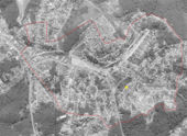
From the limiting factors slope and flooding were defined areas of priority and high priority. The priority areas have one limiting factor, the high priority area have both of factors. These are priorities areas for the implementation of green infrastructure.
-
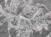
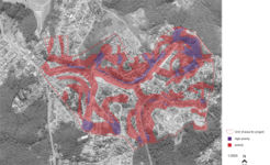 Priorities. Graphic:Pellegrino, Hisayasu. Basis: Ikonos, Cesad, FAUUSP.
 -
 Priorities. Graphic:Pellegrino, Hisayasu. Basis: Ikonos, Cesad, FAUUSP.


Analysis of use/users
-
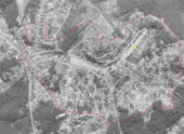
 Removal area by Corrego Limpo Program. Graphic:Pellegrino, Hisayasu. Basis: Ikonos, Cesad, FAUUSP.
 -
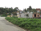
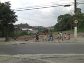
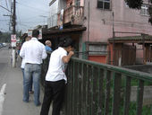
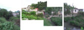
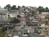 Informal settlements. Picture:Pellegrino.
 -
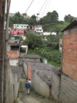
 Precarious acess. Picture:Pellegrino.
 -
 Picture:Hisayasu.
 -
 Spring underneath constructions. Picture:Pellegrino.


-
 Wetland remnant. Graphic:Pellegrino, Hisayasu. Basis: Ikonos, Cesad, FAUUSP.
 -
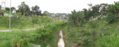
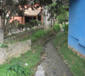
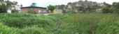 Wetland. Picture:Pellegrino
 -
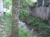
 Strategical link. Picture:Pellegrino
 -
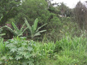 Native vegetation/Country appearence. Picture:Hisayasu


-
 Linear Park.Graphic:Pellegrino, Hisayasu. Basis: Ikonos, Cesad, FAUUSP.
 -
 Picture:Pellegrino
 -
 Street in front of the park. Picture:Hisayasu


-
 Urban improvements. Graphic:Pellegrino, Hisayasu. Basis: Ikonos, Cesad, FAUUSP.
 -
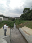
 Pedestrians. Picture:Pellegrino
 -
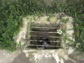
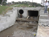 Pipped stream. Picture:Pellegrino
 -
 Water daylighting again. Picture:Hisayasu


-
 Parking lot.Graphic:Pellegrino, Hisayasu. Basis: Ikonos, Cesad, FAUUSP.
 -
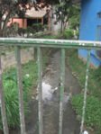
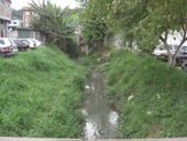 Stream. Picture:Hisayasu
 -
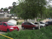 Cars on banks. Picture:Hisayasu


-
 Central area of Parelheiros Sub-Municipality. Graphic:Pellegrino, Hisayasu. Basis: Ikonos, Cesad, FAUUSP.
 -
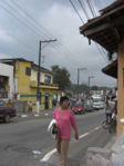 People and bikes on same sidewalk. Picture:Pellegrino
 -
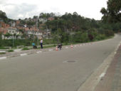
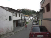 Cars and narrow sidewalk. Picture:Pellegrino
 -
 Picture:Pellegrino
 -
 Picture:Pellegrino
 -
 Picture:Pellegrino
 -
 Picture:Pellegrino
 -
 Picture:Hisayasu


Future development directions
Using Green Infrastructure to:
1. Restrain urban sprawl: defining a border, give a local identity;
2. Conserve remaining forests and its vital links for sustaining habitats and biodiversity;
3. Increase public use of open spaces for recreation, safety and public health. Maintain and restore private and public open spaces as green areas;
4. Develop an alternative urbanization model that may balance urban uses and a sustainable management of watershed areas;
5. Implement and give new functions to open spaces as linear parks, streets and sidewalks, and trails to give alternative circulation and promote new ways to experience the local landscape and reunite the population with its unique surroundings.
Peer reviews or critique
- Has the area/ project/plan been reviewed by academic or professional reviewers?
- What were their main evaluations?
Pleas add references, quotes...
Points of success and limitations
- What do you see as the main points of success and limitations of the area/project/plan?
Illustration: Summary table
What can be generalized from this case study?
- Are there any important theoretical insights?
Short statement plus background notes
Which research questions does it generate?
1. How make Green Infrastructure a real alternative to convencional urban infrastructure? Be acceptable and desired by people?
2. Could landscape architecture play a key role in this action to promote environmental control and a better awareness of the environmental issues? How to translate ecological and social issues to the design process? And implement the project!
Image Gallery
References
Please add literature, documentations and weblinks
1. Cormier, N. S., Pellegrino, P. R. M.(2008). Infra-estrutura verde: uma estratégia paisagística para a água urbana. Paisagem e ambiente: ensaios25 (2008)127-144. Edited by Universidade de São Paulo, Faculdade de Arquitetura e Urbanismo, São Paulo.
2. Costa Neto, J. B. et al (orgs.)(1997) A Reserva da Biosfera da Mata Atlântica no Estado de São Paulo. Serie Cadernos da Reserva da Biosfera da Mata Atlântica. Edited by Cetesb, São Paulo. Site: http://www.rbma.org.br/rbma/rbma_7_cadernos.asp
3. Urban Age (2008).Cidades sul-americanas:assegurando um futuro urbano. São Paulo.
4. Martins, M. L. R.(2006) Moradia e mananciais: tensão e diálogo na metrópole.Edited by FAUUSP, FAPESP, São Paulo.
5. McHarg, I. L. (1969)Design with Nature.Edited by Natural History Press, New York.
6. Meyer, R., Grostein, M. D., Biderman, C.(2004) São Paulo Metrópole.Edited by Universidade de São Paulo: Imprensa oficial do Estado de São Paulo, São Paulo.
7. Município de São Paulo, Secretaria de Planejamento Urbano.(2004) Planos Regionais Estratégicos Subprefeitura Parelheiros.São Paulo.
8. Solia, M. et al.(2007) Mananciais da Região Metropolitana de São Paulo.Graphic Designers, São Paulo.
9. Spirn, A. W. (1995)O Jardim de Granito: A Natureza no Desenho da Cidadetradução de Pellegrino, Edited by Editora da Universidade de São Paulo, São Paulo.
10. Tucci, C. E. M., Collischonn, W.(1998) Drenagem urbana e controle de erosão. Retrieved from: http://www.rhama.net/download/artigos/artigo5.pdf
- ↑ Urban Age(2008). Cidades sul-americanas:assegurando um futuro urbano. São Paulo.
- ↑ Meyer, R., Grostein, M. D., Biderman, C.(2004). São Paulo Metrópole.Edited by Universidade de São Paulo: Imprensa oficial do Estado de São Paulo, São Paulo.
- ↑ Costa Neto, J. B. et al (orgs.)(1997).A Reserva da Biosfera da Mata Atlântica no Estado de São Paulo. Serie Cadernos da Reserva da Biosfera da Mata Atlântica. Edited by Cetesb, São Paulo.
- ↑ Município de São Paulo, Secretaria de Planejamento Urbano(2004). Planos Regionais Estratégicos Subprefeitura Parelheiros.São Paulo.
- ↑ Cormier, N. S., Pellegrino, P. R. M.(2008). Infra-estrutura verde: uma estratégia paisagística para a água urbana. Paisagem e ambiente: ensaios25 (2008)127-144. Universidade de São Paulo, Faculdade de Arquitetura e Urbanismo, São Paulo.
About categories: You can add more categories by copying the tag and filling in your additional categories