Green Infrastructure 2014 Working Group F - Abdali Bridge
---> back to group page working group F
Implementing Green Infrastructure in the Abdali Bridge Area
| Name | Abdali Bridge | |
| Country | Jordan | |
| City | Amman | |
| Authors | Maroula Shami | |
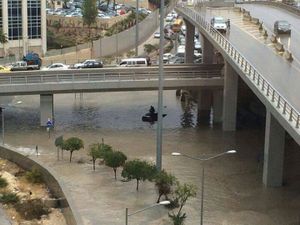
 Bridge during Rain[1] | ||
|
| ||
Rationale: Why is this case interesting?
Due to climate change, Jordan has been experiencing a change in rainfall patterns. The current grey infrastructure is not capable of draining the storm-water properly as it has not been designed to receive such large quantities. Also, the fact that it is not maintained properly further amplifies the problem. It is therefore worth considering the introduction of a layer of green infrastructure which would assist the existing grey infrastructure to avoid flooding in the future.
Author's perspective
The Abdali area underwent a radical change in the past years, the aim of which was to create a new downtown for the city of Amman. The massive mixed-used development project included the construction of residential and commercial buildings. Changes were made to the road network surrounding this project which included the construction of the Abdali Bridge. This bridge (with the roundabout below it) connects the Ministry of Interior Affairs circle (north), the Abdali project (north-east), the Abdali area (east), the Third Circle (south-east), the Fourth Circle (south), and the Shmesani area (west). During the heavy rainfall that Jordan has experienced in the beginning of November 2014, slight flooding occurred in this area, and it is speculated that an introduction of proper green infrastructure would prevent this problem from reoccurring in the future.
Landscape and/or urban context of the Abdali Bridge
Biogeography
Amman is situated on multiple hills, called Jabal(s) in arabic, which can be seen in the names of several areas like Jabal Amman, Jabal Al-Weibdeh, Jabal Al-Nadeef... etc. Originally, Amman was located on 7 hills (represented by the 7-pointed start on the Jordanian flag). The settlement on these hills, like many others, started next to a water body as these hills surrounded Wadi Ras Al-Ain which roughly translates into the valley from which the fountain springs. Since then, Amman has expanded westwards, despite the unevenness of the topography. Flat areas are a rarity in Amman, and before the automobile was used extensively, several staricases were used to connect the people. However, once the automobile became the most common mode of transportation, roads were constructed parallel to the topography of the hills in order to abide by the inclination guidelines stipulated for vehicular traffic.
Today, amman is a highly urbanized city, which was sadly designed for the automobile and lacks a pedestrian, as well as cycling, transportation network. The Ain that used to flow in the valley has dried a long time ago, and there aren't any natural water bodies in the city. Amman also lacks a properly designed and implemented green infrastructure. Although street trees are planted on all major roads, these cannot perform their role alone, and should work as a part of an extensive network of green infrastructure implemented in the city. The absence of this network is having adverse effects on stormwater management in the last couple of years. Due to Climate Change, Amman is experiencing instances of heavy rainfall as mentioned before. As a result, flooding has been occuring in the streets, especially in roads where bridges are present, as is the case with the newly constructed Abdali Bridge.
Cultural Features
The Abdali area is one of the older parts of the city and contains several important religious and civic buildings. The Palace of Justice, Ministry of Education, King Abdullah I Mosque, Church of the Annunciation, and the Coptic Patriarchate are all located on Suleyman Al-Nabulsi Street. The Jordanian Parliament and House of Senated and Representatives is located on the King Hussein Street and in the same block as the Palace of Justice. The Abdali area has been chosen for a development project on a former military site to create the New Downtown.
- Points of Interest
Palace of Justice: the major courthouse in Amman[2]
Jordanian Parliament [3]
Coptic Patriarchate in Amman[4]
Greek Orthodox Church of the Annunciation [5]
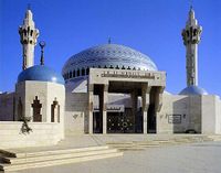
- King Abdullah I Mosque [6]
It was one of the monumental mosques in Amman and was built to commemorate King Abdullah the first in 1982. It is built on a 12 000 square meter land which was later expanded to 18 000 square meters. The mosque's major components are:

- central prayer hall: octagonal in shape and accommodates 3000 men
- Women's Prayer Hall: accommodates 500 women
- Conference Hall
- Library
- Qur'an Teaching School
- Islamic Museum
- The New Downtown [8]
It was one of the monumental mosques in Amman and was built to commemorate King Abdullah the first in 1982. It is built on a 12 000 square meter land which was later expanded to 18 000 square meters. The mosque's major components are:

Overall Character
History and Dynamics

- Illustrations: maps; sketches; short descriptive analyses
- Illustrations
- Yourimage.jpg
your visual
- Yourimage.jpg
your visual
- Yourimage.jpg
your visual
Analytical drawings
- Please use analytical drawing for visualising the conflicts/potentials of your site
- Analytical Drawings
- Your drawing.jpg
your drawing
- Your drawing.jpg
your drawing
- Your drawing.jpg
your drawing
- Your drawing.jpg
your drawing
Green Infrastructure benefits for this site
Look again at the multiple benefits of green infrastructure - what could be achieved in your site and which are most relevant?
Potential for multifunctionality
Green infrastructure has typically multiple functions. What could be achieved for your site in this respect?
Projective drawings
- How would you like this case to change in the near future? (in 1-2 years)
- you may add a short explanation here
- And how could it look like in 10-15 years?
- you may add a short explanation here
- Projective Drawings
- Yourdrawing.jpg
projective drawing
- Yourdrawing.jpg
projective drawing
- Yourdrawing.jpg
projective drawing
- Yourdrawing.jpg
projective drawing
Summary and conclusion
- 100 words approx.
Image Gallery
Please add further images/photos here
- Image Gallery
- Yourimage.jpg
your image text
- Yourimage.jpg
your image text
- Yourimage.jpg
your image text
- Yourimage.jpg
your image text
- Yourimage.jpg
your image text
- Yourimage.jpg
your image text
- Yourimage.jpg
your image text
- Yourimage.jpg
your image text
References
- ↑ Abdali Bridge. Digital image. Khaberni Page on Facebook. N.p., 3 Nov. 2014. Web. 6 Nov. 2014. <https://fbcdn-sphotos-e-a.akamaihd.net/hphotos-ak-xap1/v/t1.0-9/11568_10152793390865979_4939510335147356565_n.jpg?oh=d2465e12fa3205d7ef013958f0aa2bc4&oe=54E738E1&__gda__=1423527848_68a67ff9dc320ae7c6c4f9c4119106f1>.
- ↑ Palace of Justice, Jordan. Digital image. All of Jordan. N.p., 09 Mar. 2011. Web. 6 Nov. 2014. <http://www.hkjtoday.com/uploads/thumbs_518/c/7/c74469f8b63af01508252fac58103cc0a6ac90d4.jpg?>.
- ↑ Jordanian Parliament. Digital image. The Jordan Times. The Jordan Times, 30 Sept. 2012. Web. 8 Nov. 2014. <http://jordantimes.com/parliament-session-postponed-in-prelude-to-polls>.
- ↑ Coptic Patriarchate in Amman. Digital image. Virtual Tourist. Mikey E, 22 Nov. 2012. Web. 7 Nov. 2014. <http://www.virtualtourist.com/travel/Middle_East/Jordan/Amman-1800107/Things_To_Do-Amman-Churches-BR-1.html>.
- ↑ Church of the Annunciation. Digital image. Albisharah Church Page on Facebook. N.p., 24 Dec. 2012. Web. <https://www.facebook.com/289706634474342/photos/a.304689716309367.64602.289706634474342/304692462975759/?type=3&theater>.
- ↑ "معالم اسلامية : مسجد الملك عبد الله الأول." جريدة الدستور. Addustoor Newspaper, 20 July 2013. Web. 06 Nov. 2014. <http://www.addustour.com/16917/%D9%85%D8%B9%D8%A7%D9%84%D9%85+%D8%A7%D8%B3%D9%84%D8%A7%D9%85%D9%8A%D8%A9+%3A+%D9%85%D8%B3%D8%AC%D8%AF+%D8%A7%D9%84%D9%85%D9%84%D9%83+%D8%B9%D8%A8%D8%AF+%D8%A7%D9%84%D9%84%D9%87+%D8%A7%D9%84%D8%A3%D9%88%D9%84.html>.
- ↑ King Abdullah I Mosque. Digital image. Exploring Tourism Jordan. N.p., n.d. Web. 6 Nov. 2014. <http://www.travelojordan.com/destinations/king-abdullah-mosque/#.VFv1WMnBok4>.
- ↑ Abzakh, Shatha, Rawand Obaidat, and Batool Al-Disi. "Amman Timeline." Pixels of Fordism Graduation Project Thesis. 2014. 31. Print.
<references>Abzakh, Shatha, Rawand Obaidat, and Batool Al-Disi. "Amman Timeline." Pixels of Fordism Graduation Project Thesis. 2014. 31. Print. </reference>
About categories: You can add more categories with this tag: "", add your categories


![Palace of Justice: the major courthouse in Amman[2]](/images/thumb/4/4c/Palace_of_Justice.jpg/340px-Palace_of_Justice.jpg)
![Jordanian Parliament [3]](/images/thumb/3/3e/Parliament.jpg/433px-Parliament.jpg)
![Coptic Patriarchate in Amman[4]](/images/thumb/e/eb/Coptic_Patriarchate.jpg/361px-Coptic_Patriarchate.jpg)
![Greek Orthodox Church of the Annunciation [5]](/images/thumb/8/84/Church_of_the_Annunciation.jpg/406px-Church_of_the_Annunciation.jpg)