Naturpark Südgelände: Difference between revisions
| Line 141: | Line 141: | ||
*What transports the meanig of a place and in what form? | *What transports the meanig of a place and in what form? | ||
*How does the inclusion of the citizens improve the acceptance of the project? | *How does the inclusion of the citizens improve the acceptance of the project? | ||
[[#toc|'''Back to top''']] | [[#toc|'''Back to top''']] | ||
Revision as of 22:38, 31 January 2009
conversion of traffic area in Berlin, Germany
| Name | Naturpark Südgelände | |
| Place | Berlin | |
| Country | Germany | |
| Topic | conservation area | |
| Author(s) | Salome Gohl | |
| Completion | 2000 | |
| Client | Grün Berlin Park und Garten GmbH | |
| Project costs | unknown | |
| File:Naturpark Südgelände.jpg | ||
| <googlemap version="0.9" lat="52.46273" lon="13.355856" zoom="15" width="300" height="250">
52.459331, 13.357846, naturpark Südgelände </googlemap> | ||
Rationale: Why is this case study interesting?
This project has found a way to combine various demands as recreation, environemental aspects, a low budget with an attractive and simple design.
Due to its original function as a railway station, its interesting to see, how they deal with historic tracks and use them to create a new identity.
Author's perspective
- What theoretical or professional perspective do you bring to the case study?
As a student in landscape architecture design in open space and nature conservation seemd to me often something unlike and competitive at least on a emotianal level. You are forced to develop in one direction. Many offices are focused on one specialisation. This project shows a sustainable and conclusive collaboration.
Landscape and/or urban context
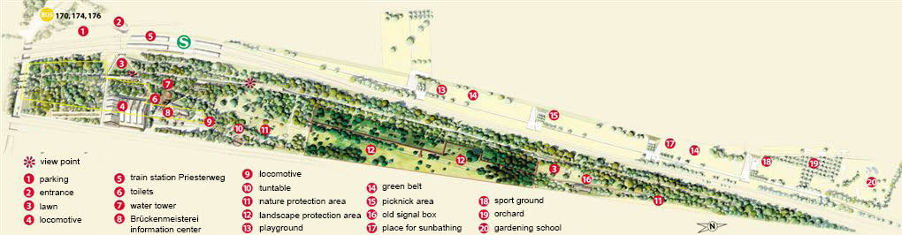
Naturpark Südgelände consists an nature conservation area, a small exibition hall, openair artwork, leftovers (e.g. Water twoer) and a circular path. It is located between two railwaytracks and was once used as a marschalling yard. Therefore its flat and of a narrow and long shape. Its entrace lies a little bit hidden behind the station and doesn't give the impression of a park on first sight. On the oposite side of the railwaytrack there is Hans-Baluscheck-Park, wich is intensly used by leisure activities as inline skating, jogging etc. That builds a strong contrast to the usage of the Naturpark but creates a dens network of open space, which covers a lot of diffrent needs, speeds and interests.
-
 zoning

Cultural/social/political context
The original idea comes from a citizens' initiative, today still active in form of guided tours and events. Responsible for the project planning and the maintenance is Grün Berlin Park und Garten GmbH, whos proprietor is Land Berlin. The project has been generously supported by Allianz Umweltstiftung.
History
Originally the place was used by railway companies mainly as marschalling yard. Up from 1952 parts were put out of service. Ecological sucsession begun. In the 70 the area was a possible site for a big marschalling yard Berlin Süd. This enterprise faild as a result of the actions of a citizens' initiative.There aim was to protect the established nature and make it accessable for the public. After a long planing time the parc was opend to the public as an external project of the Expo 2000 Hannover.
Spatial analysis of area/project/plan
The still busy railway tracks in the East and West build a clear border and give the park a long and narrow shape. This supports the caractaristic of the tracks. The pahts are leading only in one direction to only two entries. There are hardly any crosslinks. Except at the entrance, the place is more structured and fragmented. Buildings and enclosed exhibition areas divide the place in diffrent courts. Additonally the substantiation, mainly corten steel, makes a link to the industrial background. Close to the station Priesterweg the Naturpark Südgelände is well accessed and stays in close connection with the Hans-Baluschek-Park and the Insulaner.
-
 overview

Core questions working group open spaces
How does the design of an open space contribute to a run down neighbourhood?
The Naturpark Südgelände is located in a not very attractive or welll situated area of Berlin but the neigbourhood is not underserved with open space. The motivation to build this park lies more in an ecological thought than in social problems. But the original idea comes from a citizens' initiative, today they are still active in form of guided tours and events. This supports the identification of the citizens.
How are open spaces linked to the adjacent areas?
The park is well accessed due to the s-bahn station Priesterweg, a carparc, busstation and good bicycle connections. But the traffic infrastructure is also a border and isolates the park from its neigbourhood. (only two entrances)
How are open spaces used?
The areal is intensly used, mainly by promenader, nature lovers and visitors of the temporary cultural events. The park is designed for quiet usages and provides hardly any specific infrastructure. It is kind of completion to the Hans-Baluschek-Park on the oposite side of the railwaytracks wich promotes more sport activities.
Which elements make an open space successful and attractive?
A general answer is difficult and often very personal. In this case for me the strong reference to the railway and historic elements such as the watertower are central for the park und well staged. They make the place recognisale and unique. The mixture between nature and culture combined with an attractive design covers a lot of intrests and is a good base for a sustainable development. Public relations such as a good press and other popular platforms as the Expo in Hannover was, are also responsible for the familiarity and success of this park.
How can the historical background of an open space be shown to the public?
You can head facts about history form signposts and exibitions in the area. More impressiv are historic tracks on there original position. In this way you can realise the dimenson, its actual state and dynamic processes. Along the path you can see diffrent small tracks hidden between the growing plants. So you can discover new aspects. A modern design combines the old subjects using similar materials and forms with new needs, such as recreation infrastructure.
-
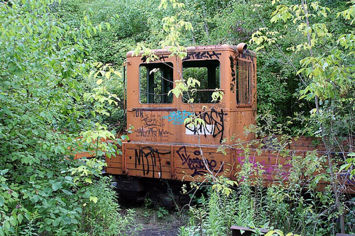 old locomotive
 -
 historic reference


In general...
Analysis of program/function
The park is mainly a conservation area and should compensate new traffic areas in town centre. A big biodiversity is well observed and documented. Cultural and artistic events take place in the old industrial buildings. It contains more quiet uses. For more intensive uses the Hans-Baluschek-Park proviedes more opportunities.
Analysis of design/planning process
In 1982 the planning approval for the expansion of the freight yard was interrupted by the citizens' initiative. With a plan for accompanying landscape preservation the meaning of the Südgelände as a lanscape and anture protection area and cold air supply was set. Seven years later it came to the decisson to include the odl freight yard as part of the BuGa 95. After this event the citizens' initiative worked closer together with the department with the joint aim to open as a project of the Expo 2000 in Hannover "Naturpark Südgelände". The planning teams were the offices Ökocon and Planland for landscape aspects and the artists of the group Odious for the artwork, all from Berlin. In 1999 the parc was opened and the nature protection decree came into effect.
Analysis of use/users
The areal is intensly used, mainly by promenader, nature lovers and visitors of the temporary cultural events. The park is designed for quiet usages and provides hardly any specific infrastructure. Due to the close railwaystation its easy reachable for a general public. The part thought for leisure aktivities, closer to the train station allows due to it's segmentation and infrastructure a wider range of usages. The part that lies northern contains only a path for walking through the conservation area.
Future development directions
As an conservation area the main goal for the future is to protect the habitat. Therefore it needs an adequate upkeep to avoid that the groves cover the hole areal. To many bigger changes wouldn't force the character of this place.
Peer reviews or critique
The park and its biota is well documented and under constant observation. Additonally there were some articles in professional journals published. (such as 'topos' http://www.chdesigns.co.uk/test%20new%20website/pdf%20docs/a%20new%20aesthetic.pdf )
Points of success and limitations
Naturpark Südgelände is a very successful project with a good acceptance. It shows a way of combining diffrent functions and demands in an urban context to new synergies. The rference to history and place as well as the contribution of the citizens carry the identification. An other positiv aspect is for me the interaction with the Hans-Baluschek-Park.
On the other hand the question, of how many contents a park of this size and neighbourhood needs and how they are translated into the design, ocures. In my opinion the artwork was in some part too ambitious and lost the connection to its original content. Some of them stand a little lost in the landscape, which was tought to have the leading part.
What can be generalized from this case study?
Additonaly to the above mentioned aspects as the successfully combined nature protection, cultural events and design as well as the careful handling of the historic substance, in my opinion, time plays a major role. The project was growing over years under collaboration of many interest groups. this is recognizable in its multilayered structure and slow development. this allows a form of participation and therefore a better acceptance but run the risk of being to ambitious and glutted.
Which research questions does it generate?
- How aesthetic can nature conservation be?
- How much can open space be decorated?
- What transports the meanig of a place and in what form?
- How does the inclusion of the citizens improve the acceptance of the project?
Image Gallery
-
 entrance
 -
 watertower
 -
 art
art -
 exhibition
 -
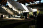 repair hall
 -
 nature on its way back
 -
 path through the conservation area
 -
 pergola
 -
 path and art in context
 -
 tunnel


References
Bürgerinitiative - http://www.bi-suedgelaende.de/index.html
Grün Berlin Garten und Park GmbH - http://www.gruen-berlin.de/sued/index.php
Senatsverwaltung für Stadtentwicklung - http://www.stadtentwicklung.berlin.de/umwelt/stadtgruen/gruenanlagen/de/gruenanlagen_plaetze/schoeneberg/naturpark_suedgelaende/index.shtml
Allianz Umweltstiftung - http://www.allianz-umweltstiftung.de/projekte_uebersicht/gruen_in_staedten/suedgelaende/index.html
Garten + Landschaft - http://www.garten-landschaft.de/index.php?Navi=15&Subnavi=19&do=artikel&id=2729
Topos - http://www.chdesigns.co.uk/test%20new%20website/pdf%20docs/a%20new%20aesthetic.pdf
About categories: You can add more categories by copying the tag and filling in your additional categories