Bogota: Difference between revisions
No edit summary |
No edit summary |
||
| Line 37: | Line 37: | ||
=== Landscape and/or urban context=== | === Landscape and/or urban context=== | ||
The Bogotá Challenge | '''The Bogotá Challenge''' | ||
The city of Bogotá, grew in the last 30 years, it passed of being a city of less than a million inhabitants to almost eigth millions, until very recently it was one of the most chaotic, insecure and ruthless cities of Latin America, with a chaotic system of transportation, parks covered with garbage, wild grass, a nobody’s land. A city affected by the urbanisation phenomenon and the migration because of the internal armed conflict. | The city of Bogotá, grew in the last 30 years, it passed of being a city of less than a million inhabitants to almost eigth millions, until very recently it was one of the most chaotic, insecure and ruthless cities of Latin America, with a chaotic system of transportation, parks covered with garbage, wild grass, a nobody’s land. A city affected by the urbanisation phenomenon and the migration because of the internal armed conflict. | ||
| Line 76: | Line 76: | ||
'''Phase 1: 1995 to 1998''' | |||
Phase 1: 1995 to 1998 | |||
To form City_Culture of Citizenship | To form City_Culture of Citizenship | ||
Transformation of a culture of citizenship is a purposeful design on the part of the government of the city. | Transformation of a culture of citizenship is a purposeful design on the part of the government of the city. | ||
| Line 94: | Line 93: | ||
The ‘citizenship program’ included the strategy of recovering the public space as a key condition for building a friendly city. This strategy encompassed educational campaigns for increase the knowledge and respect of traffic signals, improvement in the system of transportation, the construction of parks and the recovery of public space for pedestrians. | The ‘citizenship program’ included the strategy of recovering the public space as a key condition for building a friendly city. This strategy encompassed educational campaigns for increase the knowledge and respect of traffic signals, improvement in the system of transportation, the construction of parks and the recovery of public space for pedestrians. | ||
Phase 2: 1998 to 2000 | '''Phase 2: 1998 to 2000''' | ||
For the Bogotá we want _a City on a human scale | For the Bogotá we want _a City on a human scale | ||
When elected mayor of Bogota, Enrique Peñalosa (1998-2000) continued with several of the priorities of Mockus’ administration. He made of the program of recovery of public space the center of his administration. | When elected mayor of Bogota, Enrique Peñalosa (1998-2000) continued with several of the priorities of Mockus’ administration. He made of the program of recovery of public space the center of his administration. | ||
| Line 134: | Line 133: | ||
Research also shows that property values in areas with urban upgrades have appreciated considerably when compared to a control group of similar properties. All this is implemented under a healthy financial situation allowing an increasing provision of social services. | Research also shows that property values in areas with urban upgrades have appreciated considerably when compared to a control group of similar properties. All this is implemented under a healthy financial situation allowing an increasing provision of social services. | ||
2004 - 2007: Plan “ Bogotá Without Indifference” | '''2004 - 2007: Plan “ Bogotá Without Indifference”''' | ||
Luis Eduardo Garzón a left-wing Colombian political activist and a former union leader, is currently the Mayor of Bogotá, his strategic is a call to the conscience of all citizens so that we all take responsibility in the struggle to eradicate poverty and misery, which is there and we must all leave behind. | Luis Eduardo Garzón a left-wing Colombian political activist and a former union leader, is currently the Mayor of Bogotá, his strategic is a call to the conscience of all citizens so that we all take responsibility in the struggle to eradicate poverty and misery, which is there and we must all leave behind. | ||
He has not just continued with the physical transformation of the city but has enforced a strong emphasis on the social aspects that sometimes are less visible, but that contribute in giving a better life to its citizens. The “Bogotá Without Hunger” program and the effort to increase the total coverage of children in the educational cycle is noticeable, just as the programs that seek guaranteeing integral health access, combating child abuse, labor exploitation and giving more opportunities for women within a social inclusion culture | He has not just continued with the physical transformation of the city but has enforced a strong emphasis on the social aspects that sometimes are less visible, but that contribute in giving a better life to its citizens. The “Bogotá Without Hunger” program and the effort to increase the total coverage of children in the educational cycle is noticeable, just as the programs that seek guaranteeing integral health access, combating child abuse, labor exploitation and giving more opportunities for women within a social inclusion culture | ||
=== Analysis of design/planning process === | |||
'''The Construction and Building of the Public Space''' | |||
Landscape design can be an enabling tool that can facilitate new partnerships to address the pressing need to find answers for sustainable and acceptable productive green space on the edge and within cities of the 21st Century. | |||
The inclusion of landscape architects in the multidisciplinary teams that planned and carried out the projects sounds a hopeful note for the profession in other Latin American cities, which have been slow to recognize landscape architecture’s value. | |||
Public space was significantly improved from 1998 to 2006 | |||
The Defense of Public Space office helps to recover space that had been illegally occupied, and space for pedestrians was substantially renovated through improvements in sidewalks, traffic signals, lighting, and tree planting. | |||
This included the recovery of 7.000.297 (seven million) square meters of side walks and plazas, the construction of 147,000 square meters of space under bridges, the administration restored, improved, and maintained 1,234 parks, or 54% of the green space in the city; 150.000 trees planting, installed 183,651 planters, and added greenery to 202 kilometers of roadsides and 480 hectares of parks. | |||
The Master Plan of Bicycle Paths was originally going to be 450 kilometers long. Approximately 370 kilometers were completed by october 2006. This is the largest network in Latin America and the developing world. | |||
The Transmilenio (Integrated System of Mass Transport), covers the entire city, linking with bicycle paths the parks system. Construction of the Transmilenio has six phases, and in 2006 work on phase 3a. was underway. | |||
'''The Awards''' | |||
The city has won several international prices and awards during the last ten years. | |||
- Within the Latin American region, Bogotá was the first city in signing a credit with the World Bank. According to the JP Morgan and ING Baring, Bogotá received the rank of the most innovative credit in 1996 in the category of new type of client. | |||
- In October 2002 the World Health Organization recognized Bogotá’s efforts in the reduction of violence. | |||
- In 2003 The United Nations also selected Bogotá by its efforts in sustainable development. | |||
- According to the Stockholm Partnerships, the city is a model in alternative systems of transportation; the institutionalization of a ‘car-free day’ was the object of an international award, the Stockholm Challenge Award. | |||
- In 2006 at the Venezia Biennale The Golden Lion was awarded in recognition of the efforts made to improve the quality of life of the people who live in Colombia’s capital. | |||
Rethinking the city from its public spaces, imposing them as the principle of the collective and recovering the administration’s leading role in their construction and regularization are the most important challenges of those who have the opportunity and responsibility to the people, and the city. | |||
The power point presentation will higligth concepts and principles in connection with experiences from the different interventions we have participated in as leaders and/or members of interdisciplinary teams, in accordance with the premise of the five integral programs of built public space. | |||
'''1. Pedestrian Structure: Sidewalks for people | |||
2. Bicycle routes: The new way to arrive. | |||
3. Parks for learning to live | |||
4. Green Master Plan (Bogotá gets wearing green) | |||
5. Transmilenio the new urban mobility | |||
1. Pedestrian Structure: Sidewalks for people''' | |||
Structure | |||
Pedestrian spaces are made up of public goods that were built to move from one place to another, for pedestrians’ use and enjoyment, and they are also made up of architectural and natural elements from visually integrated private properties that shape urban space. They are supported by a network of sidewalks, whose main function is to make pedestrian connection between symbolical and representative elements of the urban structure. | |||
Pedestrians have historically not been respected in Bogotá. Many wide avenues, for example, did not have sidewalks. Instead of looking for ways to reduce traffic, the city team made an effort to expand pedestrian spaces. Millions of people now stroll along the 120 km of streets that have been closed to traffic, because they’re the safest place in the city. | |||
Components | |||
Structuring spaces: | |||
Places and small squares | |||
Sidewalks Network | |||
Pedestrian roads | |||
Environmental control zones, separators, cession spaces and other types of land stripes among buildings and roads. | |||
Walks and parkways | |||
Bridges and pedestrian tunnels | |||
Complementary Elements: | |||
Benches, streetlamps, etc. | |||
The urban vegetal layer, woods, gardens, plants, trees. | |||
Commemoratory Monuments and artistic objects. | |||
Other elements belonging to private property goods such as closed zones, front yards, porches, facades and layers. | |||
2. Bicycle Routes System: The new way to arrive | |||
Components | |||
The Master Plan for Bicycle Paths was originally laid out for 450 kilometers of cycleways of which approximately 370 kilometers were completed by January 2007, constituting the largest network in Latin America and in the developing world. | |||
The Bicycle Route System is made up of four functionally integrated networks that cover most of the urban and expansion lands: The main network is developed over the most important road axes that join the densely populated areas in the metropolitan center; the secondary network feeds the main network; the complementary network distributes flows to specific sectors; the environmental and recreational network consists of parks, pedestrian public spaces and metropolitan sports and recreation facilities. | |||
The system was designed to take into consideration the morphology and topography of the city. That is, from north to south the city is flat but undulates from east to west. | |||
A mesh concept was applied in the plan of the network as it presented greater versatility and adaptability given that the road network was designed as a grid, with streets going from south to north and from east to west. | |||
3. Parks System: Learning To Live | |||
Parks system | |||
A thorough, consensus-based survey to prove the deficiency of parks was necessary before the goal of providing additional parks and open space for the city could be pursued. The City Recreation and Parks Department , with the mandate from the POT, completed a Park System Master Plan in 2002 which identifies six scales of park facilities: regional parks, metropolitan/urban parks, zonal parks, neighborhood parks, pocket parks and greenway parks. | |||
With the help of a computer mapping package an inventory of existing parks and recreational facilities was produced, public needs and park resources assessed, and a plan to eliminate existing deficiencies drawn up. | |||
The System was classified as follows: | |||
Regional-scale parks | |||
Metropolitan /urban-scale Parks | |||
Zonal-scale parks | |||
Neighborhood-scale parks | |||
Pockect Parks | |||
Greenway parks | |||
Combining the power of ArcInfo and ArcView, a desktop mapping package was implemented with an inventory of existing parks and recreational facilities, an assement of Public needs and parks resources, and a plan that attempts to eliminate existing deficiencies. | |||
The master plan was the basis for developing an action plan that lays out a strategy for implementation | |||
Today Bogotá has 3,574 public parks, comprising 24 metropolitan, 63 zonal, 3,149 neighbourhood, 323 pocket parks and 13 sports facilities as well as natural areas such as hills, lineal and river ways. | |||
District Parks are green spaces for collective use that act as regulators of the environmental balance; they are elements that represent the natural heritage and ensure a free space aimed at the recreation, contemplation and leisure of all inhabitants in the city. They are arranged in order of importance as a network to ensure the city coverage; they functionally involve the main elements of the main ecological structure. | |||
4. Green Master Plan: (Bogotá gets dressed green) | |||
The Bogotá Greenering Master Plan headed by the Bogotá Protection environmental agency and the Botanical Gardens has involved a wide diversity of professionals from many fields and is well advanced in it´s realization. | |||
In spite of the fact that the Bogotá plateau is one of the great natural green houses in the world, the city does not have the threes that it should have and could have. | |||
The Master Plan set out to remedy this. The only other time that Bogotá had planted trees on a massive scale, was under the guidance of a Japanese architect in the nine teen thirties when Bogotá celebrated its 400 hundred anniversary when the recommended that “Fraxinus chinensis” be planted and nothing else. | |||
The methodology to create the plan included a long process that involved professionals from ten different fields. These experts under a landscape architect direction divided the plan into three major components: | |||
outlined the purpose and functions of arborization with the city. Fourteen points were established. The most important being in general terms: ecological, economical, esthetic and social. | |||
studied in depth candidates for massive planting both native and non native species. | |||
dedicated to mapping the city in GIS according to its distinct and diverse ecological an urban condition in relation to arborization, at same time, it was carried out a thorough inventory of the quality and quantity of the existing trees in the city. | |||
We were thus able to calculate such things as number of trees per inhabitant, by neirborhoods. | |||
5. The TransMilenio System | |||
Cities all over the developing world are struggling to come to terms with the rapid growth in motorization, which has resulted in air pollution, congestion and increased traffic accidents, the provision of public transport had traditionally been left to a unrelated group of private sector operators. With uncoordinated and relatively uncontrolled services, the operators fought amongst themselves to grab passengers. Thus, prior to the year 2000, public transport in Bogotá often meant an uncomfortable, unsafe, and generally unpleasant experience. | |||
The TransMilenio System is a proposal for change in terms of urban mobility by means of a bus-based passenger transportation system. It is founded on two general objectives: improving citizen´s quality of life, and bettering the city´s productivity on the grounds of six main principles: quality, consistency, affordably, and respect for life, user´s time and human diversity. | |||
The network has a immense impact on the urban recuperation of a degraded areas and a great transformation on the urban tissue. | |||
It is organized as a set of exclusive corridors for public transportation using modern vehicles controlled via satellite that circulate by central lanes of main arteries. | |||
Today, citizens in Bogota are showing a positive change of attitude, reflecting in spontaneous compliance with civic rules, thus generating respectful behavior and friendly coexistence, cooperation, mutual support and civil commitment. | |||
In addition, a personal sense of belonging with regard to the System is particularly strong among children as privileged contemporaneous witnesses of its birth, and its ongoing growth process in the turn of the Millenium. | |||
The results were impressive enough that Colombia finally got international press about something other than drug trafficking, guerrilla kidnappings, and bloody civil war. | |||
=== Peer reviews or critique === | === Peer reviews or critique === | ||
| Line 180: | Line 268: | ||
=== Image Gallery === | === Image Gallery === | ||
<gallery caption=" " widths="150px" heights="150px" perrow="5"> | <gallery caption=" " widths="150px" heights="150px" perrow="5"> | ||
Image: | Image:Simon bolivar.jpg|Simon Bolivar Structure Plan | ||
Image: | Image:Bogota territorial plan.jpg|Bogota Territorial Plan | ||
Image: | Image:Bogota location.jpg | ||
Image:yourimage.jpg|your image text | Image:yourimage.jpg|your image text | ||
Image:yourimage.jpg|your image text | Image:yourimage.jpg|your image text | ||
Revision as of 11:48, 28 January 2009
Bogota, The Proud Revival of a City by Martha Fajardo - Victoria Solis
| Name | Bogota, The Proud Revival of a City | |
| Place | Bogota | |
| Country | Colombia | |
| Topic | Urban Redevelopment | |
| Completion | 1991-Today | |
| style="background:Lavender" | ||
| <googlemap version="0.9" lat="4.642301" lon="-74.077377" type="satellite" zoom="14" width="300" height="250">
</googlemap> | ||
Implementation of a series of master plans in recent years has turned Bogotá from a chaotic, unsafe city into a capital with a progressive transport system, public parks, pedestrian and cycle networks. Bogotá is the capital city of Colombia.
Transforming the urban fabric of any city is an overwhelming task. The alignment of public support, political will, financial resources, and human capacity is a rare event. To achieve a transformation on the scale of a mega-city in the developing world is virtually unknown.
Cities in the Third World have experienced great change in a short time; by cataclysm, by politics and by leadership. Therefore, we professionals must come to terms with time and change. Bogotá has benefited from a series of political leaders with a highly progressive view on the importance of urban space. This degree of political will contributed to dramatic changes in several areas, including reclamation of public space and improvement of mobility.
The intention of this presentation is to present innovative solutions, document the key events, projects, and people who have helped shape the City of Bogotá, with special emphasis on the Public Space Transformation.
Author's perspective
The accomplishment: Rethinking the city from its public spaces imposing them as the principle of the collective and recovering the administration’s leading role in their construction and regularization were the most important goal of those who have the opportunity and responsibility to the people, and the city.
The goal: Bogotá is visually a different city today than it was in 1997; the changes in public space and in mobility infrastructure have translated into quantifiable improvements on incomes and social advancement. Specifically, changes in property values, employment generation, air quality, and benefits to particular income groups.
The means: What is perhaps most striking about the Bogotá project is the energetic and ingenious way in which the professional and technical team has moved beyond the theory and rhetoric, to its actual realization on the street and in the daily lives of those who live in Bogotá.
Thus, what is the main accomplishment is, the exercise in what we have to call: the Politics of Sustainability.
Landscape and/or urban context
The Bogotá Challenge The city of Bogotá, grew in the last 30 years, it passed of being a city of less than a million inhabitants to almost eigth millions, until very recently it was one of the most chaotic, insecure and ruthless cities of Latin America, with a chaotic system of transportation, parks covered with garbage, wild grass, a nobody’s land. A city affected by the urbanisation phenomenon and the migration because of the internal armed conflict.
In addition to a quantitative deficit, the city’s environment, landscape and existing urban spaces had a very low quality. Such situation was partly due to the fact that a very generic name was assigned to all of the following: the notions of “left land” and “green zone” imposed a homogeneous and anonymous reason to spaces that could become very important for the collective. Therefore, a methodology was imposed with the aim of promoting not only square meters of space, but also the user definition and the allocation of forgotten social qualities.
The diagnostic of the environmental profile performed between 1993-1996 evidenced an environmental crisis for the city and the fact that its environmental problems should be solved in an integral and combined manner by all entities of the District Administration with a straightforward collaboration of the private sector and the community. Bogotá’s chaotic growth, together with a weak attention and priority given to non-planned processes of urbanization and appropriation of urban space resulted in a significant part of the city’s population being excluded from proper social and public services.
[[Image:|left]] Illustration: Map; sketches; short descriptive analyses
Spatial analysis of area/project/plan
A City with a Plan The success of Bogotá, is remarkable given the history of disorganized growth and the surrounding adverse conditions of violence and economic recession in the country. In just a few years, innovative planning transformed Bogotá, into one of the world's leading model for sustainable urban design.
Bogotá’s cultural transformation has important lessons. The experience is politically relevant because it is taking place in a context of high levels of nation-wide violence.
These changes were the result of a cultural transformation. This transformation started with the election of Mayor Mockus (1995-1997) when he made of ‘citizenship culture’ an objective of his term in office. Cultural intervention and the built of the infraestructure continued during the administration of Mayor Peñalosa (1998-2000); and citizenship culture is taken up again in Mockus’ second term in office (2001-2003).
These changes were also the sinergy of drastical legal framework modifications in the country . The transformation of Bogotá’s politics can be understood as a shift from a national-dependent local government to a very autonomous urban governance arrangement.
The 1991 Constitution contributed to the formation of the public space by making mandatory for candidates for majors to register its political program and once elected to use that program as a foundation for the development plan. The Constitution empowered citizens by allowing them to revoke the mandate of the authority if failed to governing according to the stated program of government.
As a result of this measure, voters have been able to choose their mayors from a broader political spectrum and according to their programs of government. This is reflected in the tendency to elect ‘civic mayors’. In Bogotá’s election independent candidates won the past 3 elections.
A legislated land use program, the Plan de Ordenamiento Territorial (POT), which took effect in 1997, compelled all Colombian city councils to draft a public space renovation plan and put it into action within three years. The POT seeks to foster social and environmental sustainability through urban design, it focuses on community participation, restoring and preserving the natural environment, and improving the quality of built public space.
Bogotá also has benefited from a two political leaders with a highly progressive view on the importance of urban space. This high degree of continuity has contributed to dramatic changes in several areas, including the Reclamation of public space; the Improvement of public transport; and the progress and expansion of the municipal education system.
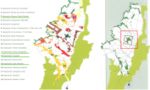
"Image:Bogota territorial plan.jpg"
©DAPD- POT 2000 Bogota Territorial Plan
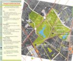
Simon Bolivar Structural Operation
"Image:Simon bolivar.jpg"
Phase 1: 1995 to 1998 To form City_Culture of Citizenship Transformation of a culture of citizenship is a purposeful design on the part of the government of the city. The Development Plan for the period 1995-97, done by Antanas Mockus echoes the linkages between culture and peaceful coexistence by stating the main objectives as : - To achieve a better accomplishment of the norms for co-existence. - Provide citizens of a better capacity to induce others to obey norms pacifically. - Increase the capacity to reach agreements and solve pacifically agreements between citizens. - Increase the capacity of communication between citizens (to express and to interpret their ideas) through art, culture, recreation and sports.
This Plan emphasized on: Culture of citizenship, Public space, Environment, Social progress, Urban productivity, Institutional legitimacy.
Mockus, a philosopher and university professor was well recognized by his pedagogical abilities - he was convinced of the importance of the exchange of knowledge and the role of the educator- his disregard for politics and his honesty as a citizen.
The concept of citizenship culture refers to “the ensemble of habits, activities and shared minimum rules intended to create a feeling of belonging, facilitate coexistence in the urban space and leading to respect collective goods and to recognize citizens’ rights and duties .”
The ‘citizenship program’ included the strategy of recovering the public space as a key condition for building a friendly city. This strategy encompassed educational campaigns for increase the knowledge and respect of traffic signals, improvement in the system of transportation, the construction of parks and the recovery of public space for pedestrians.
Phase 2: 1998 to 2000 For the Bogotá we want _a City on a human scale When elected mayor of Bogota, Enrique Peñalosa (1998-2000) continued with several of the priorities of Mockus’ administration. He made of the program of recovery of public space the center of his administration.
An economist with a doctorate in management and public administration, develop a plan ‘Por la Bogotá que Queremos’ (‘For the Bogotá we want’) aimed at the construction of a shared image of the city. Unlike Mockus’s pedagogical emphasis, Peñalosa was a great believer in the power that built public space has in shaping people’s behavior and enhancing democracy.
This Plan emphasized on City on a human scale, Mobility, Urbanism and services, Security and harmony among citizens, Institutional efficiency, De-marginalization and Social integration.
The Administration creates in 1999 the The Defense of Public Space office, which mission was to contribute to the improvement of the quality and defense of the public space, an adequate administration of the real state of the city and the construction of a new culture of the public space, that warranty’s its collective use and stimulates the participation of the community.
The creation of the entity was part of the strategy of adaptation and institutional modernization that allowed the city to recover, manage and create a public space culture and give a response to the following problems: o A need of preventing and correcting permanent and tolerated (in many cases) invasions, appropriations and exploitation of public space by individuals, which has noticeably deteriorated the city life quality, productivity, security and environment. o A system of registration, inventory and management of the district property heritage that was not updated and was managed in anti-technical and anti-functional manners. o A low sense of belonging from Bogotá’s inhabitants with regard to their environment and a low awareness of the value and importance of the public.
In order to arrange actions and projects in accordance with the POT, the model identified six urban parts that involved the construction of infrastructure networks required by the city, taking into account the following: o A reordering of the road system and a definition of the transport system that includes the new TransMilenio transportation system. o The organization of a system of equipments as a basic component of the urban structure and as a coordinator of the metropolitan, urban, zonal and local scales. o The definition of a system of parks and pedestrian public spaces to make the city accessible to pedestrians and recover the notion of the Public.
To do the public space structuring, the plan has gathered, guided and defined policies, criteria and rules for the city to be structured in an arranged and equitable manner.
It defines built public space as the support of the urban structure. In considering public space as a general system that has established its priorities and preponderances over private spaces and its roles as an element to unify, structure and order the city, elements such as sidewalks, bicycle routes, parkways, parks, paths, bridges low zones, civic places and founders places, have become networks, circuits, and urban central points that work as a continuous and compact system.
The Plan has given to the public space the power to keep an environmentally sustainable city. Through the consolidation of a city model based on a main ecological structure and a network of green spaces, the prioritization of non-motorized systems, the separation of vehicles from pedestrians and the control of advertising and other elements that affect the landscape, it has been possible to turn the Public Space into meeting space of the city with nature, where environmental pollutants from vehicles and contaminating activities have to be assumed by the individuals who generate them.
It makes possible the generation of more/better public spaces. It sets the percentages, uses and characteristics of obligatory cession zones of the urbanizing, construction and development processes. It specifies that developers and constructors must respect these public zones, deliver them and provide tools for them. It allows different mechanisms to speed up the acquisition of lands for public works and spaces. It makes possible for figures such as partial plans, and urban legalization and renewal to generate more/best public spaces in these processes. It ensures and predicts the creation and maintenance of public spaces required by new developments, as the city grows and becomes denser.
It specifies and unifies the technical conditions of built public spaces. It takes into account urban design specifications for public and private entities to built and design public spaces in a uniform, functional and secure manner. As a result, sidewalks, closings, bicycle roads, green spaces, benches, streetlamps and signalization are programmed to make up a urban landscape with aesthetic, technical and functional qualities.
It provides solutions for public space management, sustainability and management. It establishes the mechanisms for the city to be sustainable and to manage its public spaces with an active private participation and the participation of people in general. It involves executing entities in making management and administration plans.
Phase 3: 2000 to 2003 Living Together on the Same Side A culture of citizenship received a new impetus with the re-election of Antanas Mockus (2001-2003). His Development Plan “Bogotá Para Vivir Todos del Mismo Lado’ (Bogotá All living on the same side) pursued a stronger commitment of building a common space among Bogotá’s residents. As part of this strategy, citizen participation was enhanced. The development plan Living Together on the Same Side, emphasizes the capacity to reach agreements and to follow rules at the center of a democratic culture. The use of democratic procedures in the elaboration of local development plans and in changing legislation is also crucial for democracy.
Events like ‘rock and opera in the park’ and street theater congregate people from all social strata; residents get together in bicycle-paths, parks and public libraries. All this have improved the quality of life of its 7 million residents, and even more important it has contributed to save the life of at least 2,000 people a year. Bogotá has reduced in half the number of deaths due to homicides and traffic accidents. Research also shows that property values in areas with urban upgrades have appreciated considerably when compared to a control group of similar properties. All this is implemented under a healthy financial situation allowing an increasing provision of social services.
2004 - 2007: Plan “ Bogotá Without Indifference” Luis Eduardo Garzón a left-wing Colombian political activist and a former union leader, is currently the Mayor of Bogotá, his strategic is a call to the conscience of all citizens so that we all take responsibility in the struggle to eradicate poverty and misery, which is there and we must all leave behind.
He has not just continued with the physical transformation of the city but has enforced a strong emphasis on the social aspects that sometimes are less visible, but that contribute in giving a better life to its citizens. The “Bogotá Without Hunger” program and the effort to increase the total coverage of children in the educational cycle is noticeable, just as the programs that seek guaranteeing integral health access, combating child abuse, labor exploitation and giving more opportunities for women within a social inclusion culture
Analysis of design/planning process
The Construction and Building of the Public Space Landscape design can be an enabling tool that can facilitate new partnerships to address the pressing need to find answers for sustainable and acceptable productive green space on the edge and within cities of the 21st Century. The inclusion of landscape architects in the multidisciplinary teams that planned and carried out the projects sounds a hopeful note for the profession in other Latin American cities, which have been slow to recognize landscape architecture’s value.
Public space was significantly improved from 1998 to 2006 The Defense of Public Space office helps to recover space that had been illegally occupied, and space for pedestrians was substantially renovated through improvements in sidewalks, traffic signals, lighting, and tree planting. This included the recovery of 7.000.297 (seven million) square meters of side walks and plazas, the construction of 147,000 square meters of space under bridges, the administration restored, improved, and maintained 1,234 parks, or 54% of the green space in the city; 150.000 trees planting, installed 183,651 planters, and added greenery to 202 kilometers of roadsides and 480 hectares of parks.
The Master Plan of Bicycle Paths was originally going to be 450 kilometers long. Approximately 370 kilometers were completed by october 2006. This is the largest network in Latin America and the developing world.
The Transmilenio (Integrated System of Mass Transport), covers the entire city, linking with bicycle paths the parks system. Construction of the Transmilenio has six phases, and in 2006 work on phase 3a. was underway.
The Awards The city has won several international prices and awards during the last ten years. - Within the Latin American region, Bogotá was the first city in signing a credit with the World Bank. According to the JP Morgan and ING Baring, Bogotá received the rank of the most innovative credit in 1996 in the category of new type of client. - In October 2002 the World Health Organization recognized Bogotá’s efforts in the reduction of violence. - In 2003 The United Nations also selected Bogotá by its efforts in sustainable development. - According to the Stockholm Partnerships, the city is a model in alternative systems of transportation; the institutionalization of a ‘car-free day’ was the object of an international award, the Stockholm Challenge Award. - In 2006 at the Venezia Biennale The Golden Lion was awarded in recognition of the efforts made to improve the quality of life of the people who live in Colombia’s capital.
Rethinking the city from its public spaces, imposing them as the principle of the collective and recovering the administration’s leading role in their construction and regularization are the most important challenges of those who have the opportunity and responsibility to the people, and the city.
The power point presentation will higligth concepts and principles in connection with experiences from the different interventions we have participated in as leaders and/or members of interdisciplinary teams, in accordance with the premise of the five integral programs of built public space. 1. Pedestrian Structure: Sidewalks for people 2. Bicycle routes: The new way to arrive. 3. Parks for learning to live 4. Green Master Plan (Bogotá gets wearing green) 5. Transmilenio the new urban mobility 1. Pedestrian Structure: Sidewalks for people
Structure
Pedestrian spaces are made up of public goods that were built to move from one place to another, for pedestrians’ use and enjoyment, and they are also made up of architectural and natural elements from visually integrated private properties that shape urban space. They are supported by a network of sidewalks, whose main function is to make pedestrian connection between symbolical and representative elements of the urban structure.
Pedestrians have historically not been respected in Bogotá. Many wide avenues, for example, did not have sidewalks. Instead of looking for ways to reduce traffic, the city team made an effort to expand pedestrian spaces. Millions of people now stroll along the 120 km of streets that have been closed to traffic, because they’re the safest place in the city.
Components Structuring spaces: Places and small squares Sidewalks Network Pedestrian roads Environmental control zones, separators, cession spaces and other types of land stripes among buildings and roads. Walks and parkways Bridges and pedestrian tunnels
Complementary Elements: Benches, streetlamps, etc. The urban vegetal layer, woods, gardens, plants, trees. Commemoratory Monuments and artistic objects. Other elements belonging to private property goods such as closed zones, front yards, porches, facades and layers.
2. Bicycle Routes System: The new way to arrive
Components The Master Plan for Bicycle Paths was originally laid out for 450 kilometers of cycleways of which approximately 370 kilometers were completed by January 2007, constituting the largest network in Latin America and in the developing world.
The Bicycle Route System is made up of four functionally integrated networks that cover most of the urban and expansion lands: The main network is developed over the most important road axes that join the densely populated areas in the metropolitan center; the secondary network feeds the main network; the complementary network distributes flows to specific sectors; the environmental and recreational network consists of parks, pedestrian public spaces and metropolitan sports and recreation facilities.
The system was designed to take into consideration the morphology and topography of the city. That is, from north to south the city is flat but undulates from east to west. A mesh concept was applied in the plan of the network as it presented greater versatility and adaptability given that the road network was designed as a grid, with streets going from south to north and from east to west.
3. Parks System: Learning To Live
Parks system A thorough, consensus-based survey to prove the deficiency of parks was necessary before the goal of providing additional parks and open space for the city could be pursued. The City Recreation and Parks Department , with the mandate from the POT, completed a Park System Master Plan in 2002 which identifies six scales of park facilities: regional parks, metropolitan/urban parks, zonal parks, neighborhood parks, pocket parks and greenway parks. With the help of a computer mapping package an inventory of existing parks and recreational facilities was produced, public needs and park resources assessed, and a plan to eliminate existing deficiencies drawn up. The System was classified as follows: Regional-scale parks Metropolitan /urban-scale Parks Zonal-scale parks Neighborhood-scale parks Pockect Parks Greenway parks
Combining the power of ArcInfo and ArcView, a desktop mapping package was implemented with an inventory of existing parks and recreational facilities, an assement of Public needs and parks resources, and a plan that attempts to eliminate existing deficiencies. The master plan was the basis for developing an action plan that lays out a strategy for implementation
Today Bogotá has 3,574 public parks, comprising 24 metropolitan, 63 zonal, 3,149 neighbourhood, 323 pocket parks and 13 sports facilities as well as natural areas such as hills, lineal and river ways.
District Parks are green spaces for collective use that act as regulators of the environmental balance; they are elements that represent the natural heritage and ensure a free space aimed at the recreation, contemplation and leisure of all inhabitants in the city. They are arranged in order of importance as a network to ensure the city coverage; they functionally involve the main elements of the main ecological structure.
4. Green Master Plan: (Bogotá gets dressed green)
The Bogotá Greenering Master Plan headed by the Bogotá Protection environmental agency and the Botanical Gardens has involved a wide diversity of professionals from many fields and is well advanced in it´s realization. In spite of the fact that the Bogotá plateau is one of the great natural green houses in the world, the city does not have the threes that it should have and could have.
The Master Plan set out to remedy this. The only other time that Bogotá had planted trees on a massive scale, was under the guidance of a Japanese architect in the nine teen thirties when Bogotá celebrated its 400 hundred anniversary when the recommended that “Fraxinus chinensis” be planted and nothing else.
The methodology to create the plan included a long process that involved professionals from ten different fields. These experts under a landscape architect direction divided the plan into three major components: outlined the purpose and functions of arborization with the city. Fourteen points were established. The most important being in general terms: ecological, economical, esthetic and social. studied in depth candidates for massive planting both native and non native species. dedicated to mapping the city in GIS according to its distinct and diverse ecological an urban condition in relation to arborization, at same time, it was carried out a thorough inventory of the quality and quantity of the existing trees in the city. We were thus able to calculate such things as number of trees per inhabitant, by neirborhoods.
5. The TransMilenio System
Cities all over the developing world are struggling to come to terms with the rapid growth in motorization, which has resulted in air pollution, congestion and increased traffic accidents, the provision of public transport had traditionally been left to a unrelated group of private sector operators. With uncoordinated and relatively uncontrolled services, the operators fought amongst themselves to grab passengers. Thus, prior to the year 2000, public transport in Bogotá often meant an uncomfortable, unsafe, and generally unpleasant experience.
The TransMilenio System is a proposal for change in terms of urban mobility by means of a bus-based passenger transportation system. It is founded on two general objectives: improving citizen´s quality of life, and bettering the city´s productivity on the grounds of six main principles: quality, consistency, affordably, and respect for life, user´s time and human diversity. The network has a immense impact on the urban recuperation of a degraded areas and a great transformation on the urban tissue. It is organized as a set of exclusive corridors for public transportation using modern vehicles controlled via satellite that circulate by central lanes of main arteries.
Today, citizens in Bogota are showing a positive change of attitude, reflecting in spontaneous compliance with civic rules, thus generating respectful behavior and friendly coexistence, cooperation, mutual support and civil commitment. In addition, a personal sense of belonging with regard to the System is particularly strong among children as privileged contemporaneous witnesses of its birth, and its ongoing growth process in the turn of the Millenium.
The results were impressive enough that Colombia finally got international press about something other than drug trafficking, guerrilla kidnappings, and bloody civil war.
Peer reviews or critique
- Has the area/ project/plan been reviewed by academic or professional reviewers?
- What were their main evaluations?
Pleas add references, quotes...
Points of success and limitations
- What do you see as the main points of success and limitations of the area/project/plan?
Illustration: Summary table
What can be generalized from this case study?
- Are there any important theoretical insights?
Short statement plus background notes
Which research questions does it generate?
Short statement plus background notes
Image Gallery
-
 Simon Bolivar Structure Plan
 -
 Bogota Territorial Plan
 -
-
your image text
-
your image text
-
your image text
-
your image text
-
your image text
-
your image text
-
your image text


References
Please add literature, documentations and weblinks
About categories: You can add more categories with this tag: "", add your categories