Lettenareal: Difference between revisions
| Line 53: | Line 53: | ||
Illustration: Table or time line | Illustration: Table or time line | ||
<gallery caption=" " widths=" | <gallery caption=" " widths="500px" heights="300px" perrow="10"> | ||
Image:1881Siegfriedkarte.jpg|The map of 1881 | Image:1881Siegfriedkarte.jpg|The map of 1881 | ||
Image:1892.jpg|The powerstation is there | Image:1892.jpg|The powerstation is there | ||
Revision as of 21:05, 26 January 2009
History of a popular park in the heart of Zürich, Switzerland
| Name | Lettenareal | |
| Place | Zürich | |
| Country | Switzerland | |
| Topic | Parks | |
| Author(s) | Louis Wenger | |
| Completion | 2005 | |
| Client | Grün Stadt Zürich | |
| Project costs | 1.50Mio. CHF. | |

| ||
| <googlemap version="0.9" lat="47.384694" lon="8.536892" type="satellite" zoom="15" width="300" height="250" selector="no" controls="small">
47.3842, 8.537149 </googlemap> | ||
Rationale: Why is this case study interesting?
This area is a good example of how very different needs (social, environmental, and economics) can be satisfied in one really busy and crowded place. It shows how new elements can be carefully added to existing structures to improve the place without changing its character.
Author's perspective
- What theoretical or professional perspective do you bring to the case study?
Landscape and/or urban context
- Biogeography, cultural features, overall character, history and dynamics
The Lettenareal is situated on the right of the river Limmat at the foot of a hill. Because the terrain is very steep an exposed to the south, it was used to grow wine for a long time. At the end of the 19th century part of the hill was removed, to build a railway track. At nearly the same time a dam was built to use the river force for the first electrical power station of Zürich. These measures formed the area at an early stage and the terrain has reminded like this until today.

Cultural/social/political context
- Brief explanation of culture, political economy, legal framework
Illustration: Bullet points, image, background notes
History
- How did the area/project/plan at the focus of the case study evolve?
Illustration: Table or time line
-
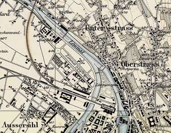 The map of 1881
 -
The powerstation is there

Spatial analysis of area/project/plan
- What are the main structural features?
- How has it been shaped? Were there any critical decisions?
Illustration: Map/diagram/sketches photos and background notes
Core questions working group open spaces
How does the design of an open space contribute to a run down neighbourhood?
A useless/run down open space can have effects to a big area. In the case of the Lettenareal it effected the whole adjacent quarter, and even the reputation of the town. The cases with the Needelpark and the Lettenpark are worst case sceneries but they happen.
These cases show that one of the real important pre-conditions is the security of open spaces, and that visitors feel safe. Most people feel safe when the place is well visited, and to be so the space has to be attractive. Attractiveness can best be produced with a good and adequate range for regeneration possibilities. What to offer depends on the users respectively.
How are open spaces linked to the adjacent areas?
The Lettenareal is an isolated place. On one side there is a steep flank of a hill, on the other side there is the dam and behind a river. There are only two entrances at both ends of this longish area.
In general in Zürich all open spaces are cellular applied, well linked for pedestrians and cycle paths and the public transport is also well linked.

How are open spaces used?
(e.g. which groups meet there, which functions does an open space fulfil)
This area is laid-out for young people. There are beach-volleyball courts, a skater area, two restaurants and a long platform for swimmers with a sunbathing area. This makes this area popular in summer, but in winter it is deserted.
Which elements make an open space successful and attractive?
-Look at how are open saces used-
In general different users have different requirements. There is a need to catch up of areas for children and elderly people. Especially places for elderly people will become very important considering the development of the population. Today most of the open spaces, as the Lettenareal, are designed only for the working population.
How can the historical background of an open space be shown to the public?
There are different ways. One of the conditions for planning Lettenareal was to change just as little as necessary. There are only few new elements, which upgrade the use of the area but which leave the character is it was. On both ends of the area there are still the lines from the railway but without the wheel tracks. And at the west end you can still see the railway station.
Analysis of program/function
- What are the main functional characteristics?
- How have they been expressed or incorporated?
Illustration: Map/diagram/sketches photos and background notes
Analysis of design/planning process
- How was the area/project/plan formulated and implemented?
- Were there any important consultations/collaborations?
Illustration: Map/diagram/sketches photos and background notes
Analysis of use/users
- How is the area/project/plan used and by whom?
- Is the use changing? Are there any issues?
Illustration: Map/diagram/sketches photos and background notes
Future development directions
- How is the area/project/plan evolving?
- Are there any future goals?
Illustration: Map/diagram/sketches photos and background notes
Peer reviews or critique
- Has the area/ project/plan been reviewed by academic or professional reviewers?
- What were their main evaluations?
Pleas add references, quotes...
Points of success and limitations
- What do you see as the main points of success and limitations of the area/project/plan?
Illustration: Summary table
What can be generalized from this case study?
- Are there any important theoretical insights?
Short statement plus background notes
Which research questions does it generate?
Short statement plus background notes
Image Gallery
-
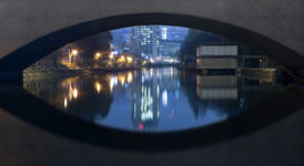 view from the bridge by the power station
 -
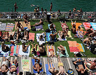 this place is very popular
 -
your image text
-
in the area lives a big population of lizards
-
your image text
-
your image text
-
your image text
-
your image text
-
your image text


[[Image:|left]]
References
Please add literature, documentations and weblinks
About categories: You can add more categories by copying the tag and filling in your additional categories asdfasdf