Green Infrastructure 2014 Working Group D - Case Study 1: Difference between revisions
| Line 140: | Line 140: | ||
'''Phase 1 (2015-2016): Awareness and Green Infrastructure project proposal''' | '''Phase 1 (2015-2016): Awareness and Green Infrastructure project proposal''' | ||
*In the forthcoming 1- 2 years | *In the forthcoming 1- 2 years, the local community and the authorities will hopefully become even more aware of the benefits of green infrastructure. Once the concept is well understood and desired, opportunities can be sought for in a collaborative way. | ||
*The implementation of green infrastructure principles for a district has to be decided by the public | *The implementation of green infrastructure principles for a district has to be decided by the appropriate public authorities (city halls, ''Mairie du 14e'' and ''Mairie de Paris'' together with other relevant entities). It will probably take at least 1-2 years to study the area and set up a call for tenders for project proposals. Once the set of actions is decided, we can go further to the implementation phase (2016-2025). | ||
'''Phase 2 (2016-2025): Green Infrastructure implementation for the 14th arrondissement''' | '''Phase 2 (2016-2025): Green Infrastructure implementation for the 14th arrondissement''' | ||
*The 14th arrondissment will be a place for people and nature with double amount of green areas which | *The 14th arrondissment will be a place for people and nature with double amount of green areas which will be inter-connected through the green infrastructure network and green transportation system designed according to the multifunctionality criteria. | ||
*'''Double amount of green areas''' | *'''Double amount of green areas''' | ||
**The amount of green areas should at least double for a healthier environment. Due to the high density of buildings there is no much open ground space, but there is an opportunity to increase the green surface by using innovative green areas: green roofs (in Paris 22 ha of roofs have been planted, out of a total potential of 80 ha.), vertical gardens and street green corridors ( | **The amount of green areas should at least double for a healthier environment. Due to the high density of buildings there is no much open ground space, but there is an opportunity to increase the green surface by using innovative green areas: green roofs (in Paris 22 ha of roofs have been planted, out of a total potential of 80 ha.), vertical gardens and street green corridors (these could be just half a meter wide using hanging plans). | ||
*'''Connectivity: green infrastructure network & green transportation''' | *'''Connectivity: green infrastructure network & green transportation system''' | ||
**In the 14th all open spaces have to be connected by green infrastructure, moreover they have to be connected with the other green spaces in the Parisian area to create a green infrastructure network. A method to do this is through green connectors which can be streets with green corridors that connect parks and open space, schools, and commercial areas to houses. | **In the 14th all open spaces have to be connected by green infrastructure, moreover they have to be connected with the other green spaces in the Parisian area to create a wider green infrastructure network. A method to do this is through green connectors which can be streets with green corridors that connect parks and open space, schools, and commercial areas to houses. | ||
**Green transportation is important for connectivity, thus public transportation (grass lined tramway), walking and cycling will be encouraged in the 14th. | **Green transportation is important for connectivity, thus public transportation (grass lined tramway), walking and cycling will be encouraged in the 14th. | ||
*'''Multifunctionality''' | *'''Multifunctionality''' | ||
**Multifunctionality can be | **Multifunctionality can be foreseen and defined as the stacking of the ecological, production, and cultural functions to achieve greater overall performance. In the 14th all open areas will be multifunctional and thus the district itself. | ||
**Cultural functions will be provided by: recreation and reflection places, education, playgrounds, | **Cultural functions will be provided by: recreation and reflection places, education spaces, playgrounds, sport areas, flourishing tourism, theaters and cinemas. | ||
**Production functions will be provided by: urban agriculture (community gardens) and bee hives, which can be located on green roofs. | **Production functions will be provided by: urban agriculture (community gardens) and bee hives, which can be located on green roofs. | ||
**Ecological functions will be provided through: biodiversity corridors, pollination (bees), local climate and air quality regulation, erosion prevention and maintenance of soil fertility, biological control (pest and disease control), moderation of extreme events and | **Ecological functions will be provided through: biodiversity corridors, pollination (bees), local climate and air quality regulation, erosion prevention and maintenance of soil fertility, biological control (pest and disease control), moderation of extreme events and urban water management. | ||
Revision as of 14:28, 19 February 2015
---> back to group page working group D
Green infrastructure potential in the 14th arrondissement of Paris
| Name | Green infrastructure potential in the 14th arrondissement of Paris | |
| Country | France | |
| City | Paris | |
| Authors | Teodora Koos-Morar | |

| ||
|
| ||
Rationale: Why is this case interesting?
The 14th arrondissement of Paris, also known as "arrondissement de l'Observatoire", is one of the 20 administrative districts of the capital of France. Paris is a crowded city, and the fact that there are not too many green spaces inside the city limits is well known. Paris has great parks and gardens but accessibility and coverage are low compared to other European capitals. Paris has only 9.4 % of public green spaces (IAU îdF, 2009), while London had 38.4 % in 2003. The amount of green areas per capita in Paris is low as well: around 13 m2/ person. The 14th arrondissement of Paris includes remarkable open areas from the Montparnasse cemetery to the Parc Montsouris, Cité Internationale Universitaire and even the grass line tramway, but they are not connected. The majority of green spaces is concentrated in the south of the district. Most inhabitants are former or current students and artists. This type of citizens are usually the ones that want and support urban renewal projects, especially for sustainable development. It is important to study the green infrastructure potential of Paris by looking at the administrative districts and trying to increase the amount of green spaces, to connect the different open spaces, and to give them multi-functionality.
Author's perspective
I have a diploma in Landscape engineering from the Faculty of Horticulture at the University of Agricultural Sciences and Veterinary Medicine of Cluj-Napoca, Romania. In 2012 I moved to Paris and graduated from the International Master in Management of Eco-Innovation, at the University of Versailles (UVSQ). After graduation, I worked as a Consultant in sustainable development and environmental communication at BIO Intelligence Service (Deloitte). Since December 2013, I am founding member and responsible of communication & landscape innovation at the newly established Institute of Innovation for Transition to Sustainability – INTRAS, in Paris. In summary, I am a Landscape engineer specialized in sustainable development. Living in Paris, I feel that the amount of green spaces is very low and not in proximity to where people live. I would like to see Paris greener, and this is why I chose to start with one of my favourite neighborhoods, the 14th arrondissement. I used to live in the Cité Internationale Universitaire campus and I often go for picnics, walks or jogging in Parc Montsouris. My vision is a system of well-connected green infrastructure elements, first at the level of this administrative district and eventually scaled-up to the whole city.
Landscape and/or urban context of your case
Paris urban context
- Geography: Paris is located in north-central France. Excluding the outlying parks of Bois de Boulogne and Bois de Vincennes, Paris has an area of about 87 km2 (8700 ha), enclosed by the 35 km ring road, the Boulevard Périphérique. In 1860 the city created the twenty clockwise-spiralling arrondissements (municipal boroughs). In 1929, the Bois de Boulogne and Bois de Vincennes forest parks were officially incorporated into the city, bringing its area to about 105 km2 (10 500 ha).
- Climate: Paris has a typical Western European oceanic climate which is affected by the North Atlantic Current. Situated midway between an oceanic climate to the west and a semi-continental climate to the east, Paris’ climate throughout the year is mild and moderately wet with mild winters and relatively clement summers. Average annual precipitation is 652 mm with light rainfall fairly distributed throughout the year.
- Green areas: Paris has more than 421 municipal parks and gardens, covering around 3000 ha with more than 250,000 trees. Between 1853 and 1870, Napoleon III and the city's first director of parks and gardens, Jean-Charles Alphand, created the Bois de Boulogne forest park (W), the Bois de Vincennes forest park (SE), Parc Montsouris(S) and the Parc des Buttes-Chaumont (NE), located at the four points of the compass around the city.
- Transport: There is a good mix of public transportation in Paris, including metro, RER, buses and tramways. Cycling takes a large portion of the urban public transport with 440 km of cycle paths and routes. The bike sharing system of Paris, Velib has more than 20,000 public bicycles distributed between 1,800 parking stations.
- Water and sanitation: In its early history, Paris had only the Seine and Bièvre rivers for water. From 1809, the canal de l'Ourcq provided Paris with water from less-polluted rivers to the north-east of the capital. From 1857, the civil engineer Eugène Belgrand, under Napoleon III, oversaw the construction of a series of new aqueducts that brought water from locations all around the city to several reservoirs built atop the Capital's highest points of elevation. From then on, the new reservoir system became Paris's principal source of drinking water, and the remains of the old system, pumped into lower levels of the same reservoirs, were from then on used for the cleaning of Paris' streets. This system is still a major part of Paris' modern water-supply network.
- Air pollution: In terms of particulate matter (pm10), Paris has the highest air pollution in France, with 38 µg/m³. Paris contributes to 12% of the regional emissions of hydrocarbons (volatile organic compounds - VOC), to 6% of the regional emissions of fine particles (PM10) and up to 11% of the nitrogen oxides emissions. In the Paris metropolitan area, the three principal sources of pollution are: transport, residential and tertiary sector (heating) and industry. Together, these sectors represent nearly 95% of CO2 emissions. Among them, road transport (cars, vehicles of delivery, motorized two-wheelers and heavy lorries) is the major problem: it is responsible for 53% of the nitrogen oxides emissions of the Greater Paris urban area, 15% of the volatile organic compounds and 25% of the particles produced by an increasing fleet of diesel vehicles.
Characteristics of the 14th arrondissement of Paris
- The 14th arrondissement of Paris is located on the left bank of the River Seine and its total land area is 5.62 km² (562.1 ha).
- The arrondissement has a high density population with 141 664 inhabitants (INSEE, 2011).
- Modern day district includes the following neighbourhoods: Quartier Montparnasse, Quartier du Parc Montsouris, Quartier du Petit Montrouge and Quartier de Plaisance. The Montparnasse district is best known for its 210 m tall skyscraper, the Montparnasse tower (Tour Montparnasse) which used to be France's tallest building until 2011. Gare Montparnasse, a major railway terminus, is located close to the tower.
- Open spaces: The most important open spaces in the 14th arrondissement are: the Montparnasse cemetery, the Parc Montsouris and Cité Internationale Universitaire de Paris. Furthermore, the grass lined tramway running on Boulevard Jourdan, Boulevard Brune and Boulevards des Maréchaux separates Parc Monsouris and Cité Universitaire.
- Architecture: Modern Paris busiest streets, avenues and boulevards today are a result of its late 19th century city renovation by Georges-Eugène Haussmann (also known as Baron Haussmann). The 14th arrondissement was re-designed by opening large avenues bordered with trees, a sophisticated network of underground sewers, vast water reservoirs and public gardens.
- In the 1970 the district became the place of experiment for contemporary urbanization. The controversy appeared with the redevelopment of Montparnasse train station and its ‘ugly’ tower, the unusual Place de Catalogne-Séoul or the opening of a vast park known as Coulée Verte along Rue Vercingétorix.
- Culture: The 14th district has traditionally been home to many artists. During the interwar period Montparnasse became the centre of artistic life and the French New Wave (Nouvelle Vague). Today, the 14th is fully dedicated to small industry and crafts and has retained a bohemian atmosphere as it hosts many artist studios with huge glass windows or residences and the international Cité Universitaire. The 14th is also the residential extension of the Latin Quarter, hosting ex-students and youth mainly due to Cité Universitaire.
Parc Montsouris
- Parc Montsouris is a public park at the southern edge of Paris. Opened in 1869, this park is one of the four large urban public parks, along with the Bois de Boulogne forest park (W), the Bois de Vincennes forest park (SE), and the Parc des Buttes-Chaumont (NE). These four have been established at roughly each cardinal point surrounding the city, the purpose being the provision of green space and recreation areas for the rapidly growing population of Paris.
- History: The park was built by Jean-Charles Alphand, the engineer who headed the service of promenades and plantations created by Baron Haussmann, The purpose of the park, according to Alphand, was "to bring life and movement to the center of a quarter until then left to isolation and abandon." Unlike the Bois de Boulogne and Bois de Vincennes, the site of the Montsouris park did not have any trees or other vegetation because it was occupied by a large stone quarry. The land area was above a network of tunnels of abandoned mines, which were filled with human skeletons. These tunnels were part of the ossuary of Paris, popularly known as the catacombs of Paris. Around eight hundred skeletons were removed from the tunnels before the construction of the park began. During the 1871 Paris Commune, the park was the site of a military encampment.
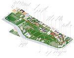
- Today: The park has 15.5 ha, and is designed as an English landscape garden. The Park contains a lake, a cascade, wide sloping lawns, and many notable varieties of trees, shrubs and flowers. It is also home to a meteorology station, a café and a theater.
- The park is bounded to the south by Boulevard Jourdan and the Cité Internationale Universitaire de Paris.
- On the eastern side there is a one-hectare artificial lake, fed by an artificial stream that passed over an artificial cascade made of rocks and cement. Stairways were constructed up the hills, with rustic-looking railings. Winding roads and paths were built throughout the park. There are picturesque gatehouses, pavilions, a theater, bandstand and a café to fit into the landscape.
- Two railway lines are crossing the park. The RER commuter line B crosses the park and the sounds of this can be clearly heard in the southern side. There are also the remains of the rails of the old Chemin de Fer de Petite Ceinture (the Little Belt), this railway line was the first public urban transportation service in Paris, and was the forerunner of today’s Paris Métro.
- Vegetation: Montsouris’ vegetation is rich and lush having trees and bushes, sloping lawns and flowerbeds. There are more than 1400 trees, most of them having over 100 years. Common trees in the park include: Horse-Chestnut (Aesculus hippocastanum); Common Yew (Taxus baccata); Cedar (Cedrus sp.); Weeping beech (Fagus sylvatica tortuosa); Buttonwood (Platanus sp.). The rarer species include: Ginkgo (Ginkgo biloba); Silk tree (Albizia julibrissin); Honey locust (Gleditsia triacanthos); Princess tree (Paulownia tomentosa); Pride of India (Koelreuteria bipinnata). The most common shrubs are: Spindle (Euonymus sp.); Mahonia (Mahonia sp.); Boxwood (Buxus sp.); Aucuba (Aucuba sp.); Viburnum (Viburnum rhytidophyllum); Tinus (Laurustinus Viburnum).
- Wildlife: Parc Montsouris has a wide variety of birdlife. An island in the middle of a tiny lake provides sanctuary to forty species of wild ducks, geese, herons, white and black swans and other migratory birds. Some turtles imported from Florida, regularly sunbathe on the lake's stony shores.
- Activities: The features of the park were designed to create an idealized natural landscape, with space for both relaxation and recreation, which could be enjoyed by all social classes of Parisians. Parc Montsouris is also a place of culture, education and recreation, and the Guignol marionette theatre is an obvious example. The roads of the park are extremely popular for joggers. The lawns are a great space for open air picnics, sports, reading or any other open air activity.
Cité Internationale Universitaire
- Cité Internationale Universitaire de Paris (CIUP) is a private park and campus of residences for students and visiting academics in the Paris region (Île-de-France) since 1925. CIUP was established after the World War I in order to create a meeting place for students, researchers and intellectuals from around the world in a spirit of peace, unity and friendly cooperation.
- CIUP today: The campus has over 34 ha, making it one of the largest Parisian parks in terms of area and architectural heritage.
- The campus comprises 40 residences and each year it welcomes 12,000 students and researchers from more than 130 nationalities. Several structures have been designed by well-known architects, such as Le Corbusier, Willem Marinus Dudok, Heydar Ghiai and Claude Parent. The residences have names dedicated to various nations (e.g. Maison de l’Argentine, Maison de Norvège), although residents in each ‘maison’ may come from any country.
- The CIUP is bounded to the south by the Boulevard Périphérique, a busy circular highway which marks the border between the city of Paris and the rest of the Île-de-France region; and to the north by the Parc Montsouris.
- Vegetation: CIUP has about one hundred different species of trees, some of which put their distinctive mark on the landscape, like the tulip tree, the Caucasian walnut or the giant sequoia. No flowers have been planted, because they might be damaged by the many athletes, families and visitors of the park.
- Wildlife: The parklands of the CIUP is home to various types of birds, from rare species such as the Mistle thrush (Turdus viscivorus) to common birds like the Carrion crow (Corvus corone).
- Sustainable development: Several areas have been refurbished, especially by planting trees. Herbicides are not used and weeding is done by steam or by hand. Informative labels have been attached to around a hundred trees. In collaboration with a university laboratory of urban ecology, the CIUP is planning to set up micro experiments on floral habitats, soil status and water management, the purpose being to enhance the ecological potential of the site.
- In 2009 CIUP and the National Museum of Natural History began a joint project to undertake an inventory of its wild flora. Each area will be maintained so as to preserve and respect the character of its landscape along with its original functions.
- In partnership with the Paris bee-keeping association, Abeille Parisienne, 6 hives, counting 300,000 bees were installed near by the Maison Internationale, and already produced a first honey crop of 90 kg.
- The early “green belt”: The campus is located on the site of the last military fortifications for Paris. At the end of the 20th century, the local authority wanted to transform them into a “green belt”. CIUP was one of the first land management organisations to become involved in this urban renewal. The intention was to create a park on the site between two areas of construction. The fine quality landscaping gives the site with its characteristic diverse architecture a deep sense of harmony.
- Due to deterioration at the beginning of the 2000’s, it was decided to restore the external surroundings of the campus so as to return them to their original state. Nearly one hundred trees have been cut to make the park’s natural lines more visible and to open up the views. The pedestrian walkways have been refurbished; benches, street lighting and drinking water fountains have been installed. A cycle park has been built and access for persons with reduced mobility has been improved.
- Renewal project - 1,800 new lodgings, 10 new residences by 2020: In April 2013 the CIUP entered a new era in its history by authorizing the implementation of a great urban project: not only the imminent construction of almost 1,800 new lodgings for students and researchers, but also the extension and reclassification of the grounds of the Cité Internationale to emphasise its scenic structure and to revitalize and rebalance the ways in which it is used.
- The ambitious objectives go beyond the mere issue of increasing accommodation availability, since it is seeking to maintain or even extend the specific purpose of the site: that of enabling students and researchers living on the Cité campus, as well as Parisians and occasional visitors, to benefit from spaces ideal for work and for meeting other people, in an exceptional scenic and architectural setting, at a standard that would be fitting the prestige of Paris and of its universities.
- The team that won the call for tenders emphasized the following points:
- The project as “flagship”: the features of each sector of the grounds (the “gardens of the world”, the broad avenue and the large park, which encloses the central lawn) will be given prominence by large scale proposals, using the idea of “urban forest” to emphasize the quality features of the Cité Universitaire and its impact on Greater Paris.
- The layers of the plant community, basis for biodiversity: the different layers of the plant community will be strengthened in order to promote biodiversity.
- The ecological corridor: the ecological corridor through the park will be reinforced both on the east-west and north-south axes between Montsouris Park, the aqueduct walk and the walk along the banks of the A6 on the territory of the towns of Gentilly and Arcueil. Part of this last walk is already completed and work on the other part is under way. The needs of pedestrians and cyclists and the ecological viewpoint will be taken even more firmly into consideration and blended together.
- To the south, the “wide bank”: the grounds will be protected from pollution from the peripheral/ring-road motorway by a landscaping device, which will delineate a wide bank along the avenue.
- Other provisions will make it possible to emphasize the southern fringe of the grounds: the gables of the residences overlooking the ring-road motorway will be treated as “pictures” so that the new houses will blend into the whole, as an expression of the identity of the Cité. The protective landscaping device facing the ring-road motorway could take the form of an embankment treated as a “tree-lined ribbon” which will glide beneath the houses and cover their communal spaces.
- The works scheduled in the second phase (2019-2020) will concern the extension and reclassification of the park.
- Illustrations
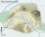
Elevation map of Paris' valleys and highest buttes, also included: Paris' existing and defunct rivers and major and minor waterways (http://en.wikipedia.org/wiki/User:ThePromenader#mediaviewer/File:Jms_paris_elevation_map_2012.jpg)
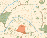
Green areas in Paris and the 14th arrondissement (http://en.wikipedia.org/wiki/14th_arrondissement_of_Paris#mediaviewer/File:Paris_14e_arr_jms.gif)
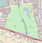
Map of Parc Montsouris (http://en.wikipedia.org/wiki/Parc_Montsouris)
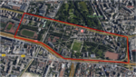
Map of Cité Internationale Universitaire de Paris


Analytical drawings
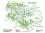
In the image it can be clearly seen that Paris has a low amount of green areas. Most of the green areas in the Île-de-France region are outside the boundary of the city of Paris. (http://www.iau-idf.fr/index.php?id=615&iaurif_publications_aff%5Betude%5D=882&cHash=cc036c515913178f28a5e3623a3a2dec)
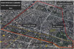
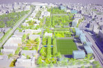
Map of green infrastructure elements in the 14th arrondissement

Green Infrastructure benefits for this site
Green infrastructure benefits are the various types of positive impacts that green infrastructure can provide to societies and ecosystem. They can be classified into three large categories: social, environmental and economical.
Social benefits
- Quality of life: An increased amount of green areas in proximity to where people live will increase the overall quality of life of the inhabitants in the 14th.
- Health: Having nature closer to citizens will have positive effects on their health, both physical and mental. Greening urban areas can reduce the number of people dying from heat-related health problems. The researchers found that doubling vegetation cover in central Melbourne could reduce heat-related mortality of the elderly by up to 28% during heat waves (Science for environment policy, EC 2014).
- Green jobs: By implementing green infrastructure new jobs will be created for the development of the projects and furthermore for their maintenance.
- Community spirit and participation: In the implementation of green infrastructure inhabitants should be asked to participate. Only with their help will public bodies know where to act at first, because the views of the citizens’ motivations and preferences is the best indicator of the directions for a future better quality of life in the city. For example, for urban community agriculture projects citizens have to be actively involved in their maintenance.
Environmental benefits
- Decreased heat island effect and droughts: Green infrastructure in the 14th offers opportunities to mitigate drought and heat island effects during summer, mainly due to evapotranspiration.
- Decrease global temperature: The latest summers were unusually hot, and because in Paris high temperatures last only for several weeks, most of the houses and offices do not have air conditioning. More vegetation will help decreasing the overall temperature in the city.
- Reduced water runoff: By creating more surfaces with permeable soils, green infrastructure decreases flooding risks.
- Reused water: Paris has high annual precipitation levels. In the 14th, rain water can be collected and stored to be used for the irrigation of green areas.
- Biodiversity: By creating green corridors in the 14th, district biodiversity will find its way back in the city easier. Already Cité Universitaire includes bee hives, and with urban agriculture and more diverse green areas, habitat for wildlife will be created.
Economical benefits
- Local products: Growing urban agriculture will increase the overall economy of the 14 th.
- Green jobs: New projects will help to decrease unemployment and to diversify the job market.
- Reduces costs for irrigation: Using rain water for irrigation will reduce maintenance costs.
- Reduced cost for maintenance: Using traditional fertilization and phytoremediation will reduce total costs.
- Tourism: Already the 14th receives a lot of tourists. The main attractions are the Montparnasse tower and the Denfert-Rochereau catacombs, but also very noticeable attractions are the Montparnasse cemetery and the Monsouris park. By developing a state-of-the-art green infrastructure, the district can attract more visitors, and even contribute to the education of engineers, landscape architects and other people interested in green infrastructure.
- Flood alleviation and management: The 14th district will have a storm-water management procedure that will take into account all natural and socio-economic aspects, from soil permeability areas to land-use decisions. As well, by creating more permeable soils due to the increased amount of green areas flood risks will decrease.
Potential for multifunctionality
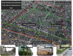
Multifunctionality for the 14th arrondissement of Paris

Projective drawings
Phase 1 (2015-2016): Awareness and Green Infrastructure project proposal
- In the forthcoming 1- 2 years, the local community and the authorities will hopefully become even more aware of the benefits of green infrastructure. Once the concept is well understood and desired, opportunities can be sought for in a collaborative way.
- The implementation of green infrastructure principles for a district has to be decided by the appropriate public authorities (city halls, Mairie du 14e and Mairie de Paris together with other relevant entities). It will probably take at least 1-2 years to study the area and set up a call for tenders for project proposals. Once the set of actions is decided, we can go further to the implementation phase (2016-2025).
Phase 2 (2016-2025): Green Infrastructure implementation for the 14th arrondissement
- The 14th arrondissment will be a place for people and nature with double amount of green areas which will be inter-connected through the green infrastructure network and green transportation system designed according to the multifunctionality criteria.
- Double amount of green areas
- The amount of green areas should at least double for a healthier environment. Due to the high density of buildings there is no much open ground space, but there is an opportunity to increase the green surface by using innovative green areas: green roofs (in Paris 22 ha of roofs have been planted, out of a total potential of 80 ha.), vertical gardens and street green corridors (these could be just half a meter wide using hanging plans).
- Connectivity: green infrastructure network & green transportation system
- In the 14th all open spaces have to be connected by green infrastructure, moreover they have to be connected with the other green spaces in the Parisian area to create a wider green infrastructure network. A method to do this is through green connectors which can be streets with green corridors that connect parks and open space, schools, and commercial areas to houses.
- Green transportation is important for connectivity, thus public transportation (grass lined tramway), walking and cycling will be encouraged in the 14th.
- Multifunctionality
- Multifunctionality can be foreseen and defined as the stacking of the ecological, production, and cultural functions to achieve greater overall performance. In the 14th all open areas will be multifunctional and thus the district itself.
- Cultural functions will be provided by: recreation and reflection places, education spaces, playgrounds, sport areas, flourishing tourism, theaters and cinemas.
- Production functions will be provided by: urban agriculture (community gardens) and bee hives, which can be located on green roofs.
- Ecological functions will be provided through: biodiversity corridors, pollination (bees), local climate and air quality regulation, erosion prevention and maintenance of soil fertility, biological control (pest and disease control), moderation of extreme events and urban water management.
Vision

Summary and conclusion
Paris, the city capital of France, has a deficit of open green spaces (13 m2 of green area/person) and thus its inhabitants are most of the time forced to travel far away inside or outside of the city to enjoy the benefits of public gardens, parks or forests.
The city is large and very urbanized and this makes it difficult to assess the green infrastructure potential for the whole city, which is why I chose to study one of its 20 administrative districts, the 14th arrondissement. The district includes remarkable open areas from the Montparnasse cemetery to the Parc Montsouris, Cité Universitaire and even the grass line tramway, but they are not connected. Except for street trees, the green spaces are concentrated on the southern border of the district.
I took a holistic approach and I envisioned the 14th arr. as a place for people and nature alike, with twice the amount of green areas (e.g. innovative green areas: green roofs with a potential of 60 ha., vertical gardens and street green corridors) which are connected through the green infrastructure network (e.g. green connectors which can be streets with green corridors) and green transportation. In the 14th all open areas will be multifunctional by providing cultural, production and ecological functions.
Image Gallery
- Image Gallery
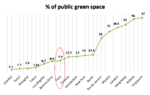
Percentage of public green spaces in major cities
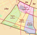
Neighborhoods within the 14th arrondissement. (http://www.travelfranceonline.com/paris-14th-district-14eme-arrondissement/)
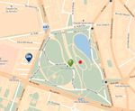
Detailed map of Parc Montsouris
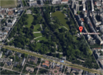
Google Earth view of Parc Montsouris
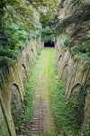
The abandoned railway track of The Petite Ceinture passes through Parc Montsouris. (http://en.wikipedia.org/wiki/Parc_Montsouris)
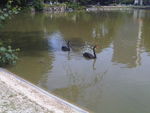
Black swans in Parc Montsouris
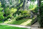
Rustic stairs in Parc Montsouris (http://parisdartiste.wordpress.com/tag/parc-montsouris/)
Student houses in the Cité Internationale Universitaire (http://insitu.revues.org/855)
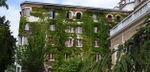
Maison of Cite Universitaire having a green facade (http://www.ciup.fr/en)
Renewal project 1,800 new lodgings & 10 new residences for Cite Universitaire (http://www.paris.fr/pratique/vie-etudiante/maison-des-initiatives-etudiantes/10-nouvelles-maisons-pour-la-cite-universitaire-internationale/rub_5327_actu_128645_port_24091)


References
- INSEE, 2011: http://www.insee.fr/fr/ppp/bases-de-donnees/recensement/populations-legales/departement.asp?dep=75
- 14th arrondissement of Paris - Wikipedia: http://en.wikipedia.org/wiki/14th_arrondissement_of_Paris
- Paris - Wikipedia: http://en.wikipedia.org/wiki/Paris
- Travel France Online: http://www.travelfranceonline.com/paris-14th-district-14eme-arrondissement/
- Parc Montsouris - Wikipedia: http://en.wikipedia.org/wiki/Parc_Montsouris, http://fr.wikipedia.org/wiki/Parc_Montsouris#Lieux_et_observations_remarquables
- Air Quality in Europe: http://www.airqualitynow.eu/city_info/paris/page2.php
- Airparif: http://www.airparif.asso.fr/en/pollution/differents-polluants
- Cité Internationale Universitaire de Paris - Wikipedia: http://en.wikipedia.org/wiki/Cit%C3%A9_Internationale_Universitaire_de_Paris
- Cité Internationale Universitaire de Paris: http://www.ciup.fr/en
- Mairie de Paris: http://www.paris.fr/pratique/vie-etudiante/maison-des-initiatives-etudiantes/10-nouvelles-maisons-pour-la-cite-universitaire-internationale/rub_5327_actu_128645_port_24091
- Science for environment policy, EC 2014: http://ec.europa.eu/environment/integration/research/newsalert/pdf/heatwaves_urban_areas_reduce_mortality_heatwaves_387na5_en.pdf
- World Cities Culture Forum - indicators: http://www.worldcitiescultureforum.com/indicators/public-green-space-parks-and-gardens
- IAU îdF: http://www.iau-idf.fr/index.php?id=615&iaurif_publications_aff%5Betude%5D=882&cHash=cc036c515913178f28a5e3623a3a2dec
- The Guardian: http://www.theguardian.com/environment/2013/may/04/paris-green-roofs-building-climate-environment
About categories: You can add more categories with this tag: "", add your categories