Collaborative Green Infrastructure Design Group L: Difference between revisions
| Line 104: | Line 104: | ||
<gallery caption="Image Gallery" widths="150px" heights="150px" perrow="4"> | <gallery caption="Image Gallery" widths="150px" heights="150px" perrow="4"> | ||
Image: | Image:Buried Parts.jpg|Buried Parts | ||
Image: | Image:Abandoned Parts.jpg|Abandoned Parts | ||
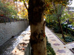
Image: | Image:Blue Structures.jpg|Gray Structures | ||
Image: | Image:Visual and Tactile Disconnection.jpg|Visual and Tactile Disconnection | ||
</gallery> | </gallery> | ||
== References == | == References == | ||
Revision as of 02:25, 26 January 2015
---> back to group page working group L
Restoration of Darband River Valley with the Approach to a Green, High Quality Transportation Network
| Name | Darband River Valley | |||||||||||
| Location | Tehran | |||||||||||
| Country | Iran | |||||||||||
| Authors | Ana Žmire, Shahla Shahmoradi, Fernanda Millán, Simona Sava-Paval | |||||||||||

| ||||||||||||
| {{#widget:GoogleMaps | width=300 | height=200 | lat=35.696111 | lng=51.423055999999974 | zoom=10 | centermarker=yes | maptypecontrol=yes | overviewmapcontrol=yes | largemapcontrol=yes | scalecontrol=yes
}} | ||
Landscape and/or urban context of your case
- Biogeography, cultural features, overall character, history and dynamics
- Climate, water, and soil
Tehran is a mountainside city with an altitude of 900 to 1700 meters above the sea level located on the southern slopes of Alborz mountains. From east to west, the view is dominated by the Alborz mountains, with rivers that are full in springtime and dry in summertime, flowing to satiate underground water tables hidden in the very thick layers of sedimentary rocks (gravel, sand and clay) from the Quaternary. Multiple aqueducts bring the water to surface that, in turn, flows through irrigation canals and brooks along all streets and avenues of Tehran. Lower parts, between 900 to 1200 m, have a fertile soil and gentle slope that permit a productive agricultural activity. In these plains, there are many sources of surface or underground water tables, supplied by aqueducts, floodways and branched out rivers. In the south of Tehran, the desert begins. Dry and very hot weather in summer and sometimes very cold in winter, make this region seem hostile. The contrast between mountain and desert, and even between north and south of the City, prevents weather crises from taking shape in any part of the year. When heavy snow obstructs mountain roads, plains in the rim of the desert have often a mild sunny weather. Tehran region has a dry climate. The annual rate of rainfall is only 229mm at the downtown, 400mm in northern neighborhoods and less than 150mm in arable lands of south. Heavy rainfalls in Alborz mountains, mainly as snow, provide a fairly reliable source of water supply for Tehran’s residents and the City’s development. This water flows through a number of rivers and flood canals toward the desert in the south and is swallowed up by the thick layers of alluvium.
- Main River Valleys in the City
Seven main river valleys pass through the city, including Darakeh, Velenjak, Darband, Golab Dareh, Jamshidyeh, Darabad, and Kan. All of these come from Alborz Mountains of Tehran, and after passing through urban areas reach lower plains in the south, where they meet agricultural lands. This case study concentrates on Darband river valley. This river (“the Furious River” with 295/000/000 m3 of water per year) flows down from North mountains, passes beyond Hezardarreh hills, east of Tehran, and irrigates the great arable plain of Varamin.
- Overall Character and Current Conditions
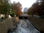
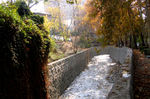
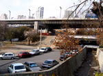
By carefully looking at the map, Darband river valley and its path is recognized due to its especial natural form. But if we want to follow it in the city, it is not so easy. Some parts of it have been buried under buildings or streets. Other parts of it have been converted to "U" channels and covered by impervious materials such as stone. In terms of flora, except some scattered trees, which are planted alongside the wall of the river valley, there is not major planting adjacent to that. Actually the deep channels surrounding the bed of the river valley has taken the opportunity to plant trees, shrubs, or other kinds of vegetation. Right after the end of the river's walls, there are streets and buildings. This lack of attention to Darband river valley causes people to undermine it and throw their wastes in this river-channel, and this in turn causes major environmental pollution in the site.
- Flora
Tehran is rich in terms of the diversity of flora. While some of them are native to Iran, few, if any, of them are endemic to Tehran. Up to now, 13 endemic species of Tehran are known: Eritrichium mertonii (Family Boraginaceae), Buffonia hebecalyx (Family Caryophyllaceae), Stellaria scaturiginella (Family Caryophyllaceae), Centaurea carduiformis subsp. iranica (Family Compositae), Tanacetum polycephalum subsp. junesarens (Family Compositae), Taraxacum darbandense (Family Compositae), Convolvulus gracilininus (Family Ipomoea), Astragalus latianicus (Family Papaveraceae), Astragalus pseudobrunsianus (Family Papaveraceae), Hedysarum elbursense (Family Papaveraceae), Hedysarum hyrcanum var. hyrcanum (Family Papaveraceae), Vicia sojakii (Family Papaveraceae), Galium tehranicum (Family Rubiaceae). All of these species are herbaceous, which aren’t currently used in parks and landscapes. Predominant species of Tehran which are widely planted in parks, streets, and open spaces as well as alongside the river valleys are Platanus orientals, Morus nigra, Ulmus minor ‘umbraculifera’, Fraxinus excelsior, Quercus spp of broadleaved trees; Pinus eldarica and Cupressus arizonica of conifers; Lignustrum vulgare, Viburnum opulus, Nerium oleander, Berberis thunbergii of shrubs; and Common grass and Hedera helix of cover plants.
- Connectivity to the Wider Green/Gray Structures
Darband river valley in its journey from Alborz Mountains toward plains through the middle of the city links many important services and facilities from urban to local scales. One of the most important structures is North Mountains itself, which during the week and weekends attract thousands of people to hike, mount, and spend leisure time. On the other hand, the river valley passes through main, high traffic roads and highways, which everyday millions of citizens use to go their work. All of these green/Gray structures stress the importance of this historical river valley and affect the river both negatively and positively. Before such an incredible development of the city, when all of the city with its borders was limited to current city center, most parts of these river valleys were far away from the city and its effects. At that time, mostly private gardens and orchards formed their banks.
- Illustrations: maps; sketches; short descriptive analyses
- Illustrations
-
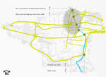
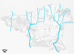 Main River Valleys
 -
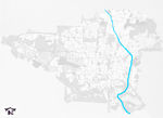 Situation of Darband River Valley
 -
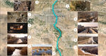 Journey of the River Valley from Mountains to Plains


What are the overall objectives of your design? What are the specific objectives for enhancing green infrastrucutre?
Please give a short written argumentation (not more than 150 words). It is ok if you have different or even contradicting objectives within your group. Just make it explicit at the beginning of your process
Analytical drawings
Please add four analytical sketches/drawings (or montages/schemes) of your case. Every group member needs to contribute at least one drawing.
- Analytical Drawings
-
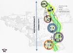
 Social nodes along the Darband river valley/Shahla Shahmoradi
 -
 Traffic analysis/Shahla Shahmoradi
 -
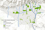 Forman - Godron landscape ecology analysis shows that patches of open green spaces are scattered all across the city with no green connection between them. River valleys form separate corridors from north to south. Urban tissue matrix needs more patches of open green spaces that are interlinked with ecological corridors./Ana Žmire
 -
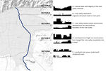 Cross sections of the Darband River valley/Ana Žmire


Projective drawings
Please add four projective sketches/drawings (or montages/schemes), of course with an emphasis on green infrastructure aspects. Every group member needs to contribute at least one drawing representing his/her individual ideas.
- Projective Drawings
-
 Green Transportation network along the restored river valley/Shahla Shahmoradi
 -
 Creating multifunctional green infrastructure/Shahla Shahmoradi
 -
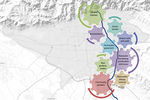 Green infrastructure elements that would improve Darband River valley/Ana Žmire
 -
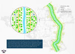
 Different zones of green infrastructure with an emphasis on different activities that would bring many benefits to the citizens/Ana Žmire


Design Synthesis
Please analyse the individual approaches presented so far and evaluate their strengths and weaknesses (you may use the SWOTanalysis model). Try to create a synthesis and represent it with a plan and some sketches. You can still use drawings/sketches.
- Design Synthesis Drawings
-
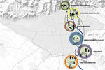
 Zones of green infrastructure interconnected with Green Transportation network
 -
 Green infrastructure solutions for Darband River valley
 -
synthesis drawing 3
-
synthesis drawing 4


Summary of the collaborative process
“From my point of view, our collaborative design process was a good teamwork through which I have learned to approach the project in the other way and effectively communicate in such a virtual world. I trained myself to evaluate the site from a landscape architect’s point of view. I didn’t find a major difficulty, we easily interacted with each other and shared our thoughts. I think collaborative design is a challenging process that if the members have most thoughts and behaviors in common, it can be a valuable, useful experience.” Shahla Shahmoradi
“Our collaborative design process was indeed teamwork, we came with different professional backgrounds and different visions for site improvement that we discussed and successfully banded together. We had no problems communicating and resolving issues we came across. This assignment made me explore the city that is culturally completely different from mine, has a rich past and I hope I’ll be able to visit it someday. During our collaborative design process I came across some difficulties concerning the site and accessing additional information on the internet (due to language differences) but Shahla managed to resolve all my problems and provide me with needed information. Collaborative design is always a challenge and especially while not being able to communicate and share thoughts personally, but despite all that I had a good time and have learned a lot during last few months of this seminar." Ana Žmire
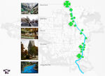
Image Gallery
You may add a series of images/photos in addition to the sketches/drawings
- Image Gallery
-
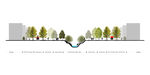
 Buried Parts
 -
 Abandoned Parts
 -
 Gray Structures
 -
 Visual and Tactile Disconnection


References
1. Aminzadeh, B., Khansefid, M. (2010). A case study of urban ecological networks and a sustainable city: Tehran’s metropolitan area. Urban Ecosystems 13 (2010): 23-26.
2. Fathejalali, A., Masoudi, M. (2011). Corridor Plans: An Opportunity to Develop Low Carbon Open Spaces Network-The Case Study in Tehran, Iran. Corridor Plans and Open Spaces Network, 47th ISOCARP Congress (2011).
3. Habib, F., Atabi, F., Laghaei, H., Mousavi Fatemi H., Janfada, K. (2014). Design of Dareh-Darakeh Nature Park for Ecotourism Development in Tehran Metropolitan City. International Journal of Ecosystem 4(5) (2014): 224-232.
About categories: You can add more categories with this tag: "", add your categories