Erika Jureviciute. Former US Army areas in Heidelberg: Difference between revisions
Jureviciutee (talk | contribs) |
Jureviciutee (talk | contribs) |
||
| Line 167: | Line 167: | ||
Image:P1260012.JPG|your image text | Image:P1260012.JPG|your image text | ||
Image:P1260027.JPG|your image text | Image:P1260027.JPG|your image text | ||
Image: | Image:P1260053.JPGg|your image text | ||
Image:yourimage.jpg|your image text | Image:yourimage.jpg|your image text | ||
Image:yourimage.jpg|your image text | Image:yourimage.jpg|your image text | ||
Revision as of 12:26, 7 December 2014
---> back to group page working group D
please add your title here
| Name | Conversion zone: Former US military teritories/US Hospital | |||||||||||
| Country | Germany | |||||||||||
| City | Heidelberg | |||||||||||
| Authors | Erika Jureviciute | |||||||||||

| ||||||||||||
| {{#widget:GoogleMaps | width=300 | height=240 | lat=49.3753785 | lng=8.6840666 | zoom=14 | centermarker=yes | maptypecontrol=yes | overviewmapcontrol=yes | largemapcontrol=yes | scalecontrol=yes
}} | ||
Rationale: Why is this case interesting?
Former military areas include a total of 5 areas with an approximate area of 180 ha. All 5 areas are located in the West of the river Neckar in Kirchheim, Südstadt and Rohrbach. In summer 2014 the Americans have their last area returned. Heidelberg is planning to buy all the former military sites and pass them to suitable investors. These five areas have very different structure.
Patrick Henry Village and Mark Twain Village were established as housing estates. Institutions like schools, kindergardens and sport facilities ensured a good social infrastructure. Cambell and Patton Barracks consist mostly of military utility buildings – partially historical buildings. US hospital and Airfield building structure is alligned on their specific use for army hospital and airport.
Author's perspective
I have a bachelor in Landscape architecture, which I did in my country Lithunaia. After my studies I came to Germany, Heidelberg for an internship. Now I work here as landscape architect in the same firm for almost a year. I think the conversion zones in Heidelberg is a very discussable theme at this time. The areas are closed and the teritory is not accessible for the public. 5 days a week I go to work on my bike and I pass two former military teritories: airfield and Patton Barracks. The areas are restricted with big fences and look really cold.
Landscape and/or urban context of your case
- Campbell Barracks and Mark Twain Village
The Campbell Barracks and Mark Twain Village are located in the south of Heidelberg and take 43,4 ha. Campbell Barracks – the former headquarters of the US Army. Mark Twain Village – the residential area with infrastructure. Construction work on Mark Twain Village began in 1948. In addition to residentian facilities there were built schools, kindergardens, sport and church facilities in the social and cultural field.
The areas are reached through the inner – city. The public transport connections to these places are really good.
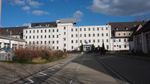
US Hospital
The area of the US Hospital is located in the south of Rohrbach at the Karlsruhe street. It was the hospital for the army people and their families living in Heidelberg, Mannheim, Worms and Karlsruhe.
The US Hospital is the smallest area for redevelopment. 1,8 ha are built up. The basic structure and functionallity of the buildings are mostly directed with the hospital operations. Two buildings on the east, the former sporthall and theater are buildings to be conserved.
The area is very easilly accessible with the individual and public transport. Currently the area is accissible from Karlsruhe, Freiburger and Kolbenzeil streets.
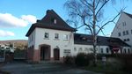
Patton Barracks
The oldest buildings in Patton Barracks date back to the period before the First World War. Until the Second World War, there was continual extensions. In 1945 the Americans took the area and named it after General George S. Patton.
On the east of the area are different utilization buildings: residential and office buildings, an officer casino, theater, chucrh and a sport hall. The entire are is largely sealed. The area in the future could conect the city with the emerging southern parts of Heidelberg.
The accessibility by private and public transport is very good.
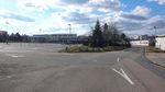
Airfield
The airfield the US Army
The US Army airfield is located in Kirchheim district. In the north, directly adjacent to the district called Pfaffengrund. This area is less built up. With a total area of 15,6 ha, buildings occupies only 1,8 ha. The buildings mainly belong to the airport. The runway extends over 1,070 meters with a wide of 30 meters.
In Sptember 2002, the American aircraft were transferred to Mannheim and Wiesbaden. Since then, the airfield was still used as the starting and landing area for the helicopters and American fire services. In 2014 April, the property was passed. Public roads cross the former runway.
The area is accessible by car via Diebsweg, which connects Kirchheim and Pfaffengrund. A direct public transportation to the aformer airfield does not exist.
Patrick Henry Village
Residential area in the south – west
Patrick Henry Village, located in Kirchheim district, was built in the years 1952 – 1955 by the US Army as a residential area. The area was named after Patrick Henry, a politician at the time of American independence.
It is the largest former military area in Heidelberg. There are two types of houses available: in the north – single family homes and in the south larger buildings. In 2014 the area was given to the Federal Agency for Real Estate.
Patrick Henry Village has the character of a small American town. The area is located outside the contigous settlement area of Heidelberg. Up to eight thousand Americans living here had a variety facilities such as shops, sport facilities, cinema, kindergardens and schools.
The accessibility by private and public transport is good. The highway separates the village from the urban area of Heidelberg
- Illustrations: maps; sketches; short descriptive analyses
- Illustrations
-
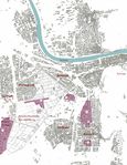 Heidelberg map:Conversion zone
 -
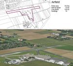 Airfield
 -
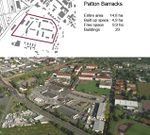 Patton Barracks
 -
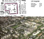 US Hospital
 -
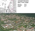 Campbell Barracks Mark Twain Village
 -
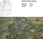 Patrick Henry Village
 -
your visual
-
your visual


Analytical drawings
- Please use analytical drawing for visualising the conflicts/potentials of your site
- Analytical Drawings
-
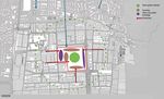
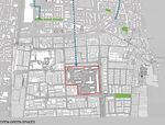 Open green spaces
 -
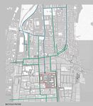 Bicycle paths
 -
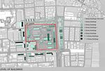 Building levels
 -
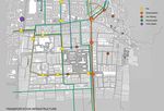 Transportation infrastructure
 -
your drawing


Green Infrastructure benefits for this site
Look again at the multiple benefits of green infrastructure - what could be achieved in your site and which are most relevant?
Environmental benefits
Improved air quality by incorporating trees and vegetation in an urban landscape. Retaining rainwater by introducing vegetation and soils, that are capable to absorb water. Providing shading by planting big trees Reduced energy demands by increasing the green spaces.
Social benefits
Public health improvement by reducing the pollution and improving air quality, creating sport activities in the area. Providing recreationall areas by creating parks, water recreation, green alleys and playgrounds in the urban landscape. Social interaction increasement will be achieved by creating gathering palces for community
Economic benefits
New job opportunities will be created by introducing new workforce in the area. Lower maintenance cost and Reduced energy
Potential for multifunctionality
Green infrastructure has typically multiple functions. What could be achieved for your site in this respect?
Projective drawings
- How would you like this case to change in the near future? (in 1-2 years)
- you may add a short explanation here
- And how could it look like in 10-15 years?
- you may add a short explanation here
- Projective Drawings
-
 My vision
 -
projective drawing
-
projective drawing
-
projective drawing

Summary and conclusion
- 100 words approx.
Image Gallery
Please add further images/photos here
- Image Gallery
-
 your image text
 -
 your image text
 -
 your image text
 -
 your image text
 -
your image text
-
your image text
-
your image text
-
your image text


References
- please add your references here
About categories: You can add more categories with this tag: "", add your categories