Green Infrastructure 2014 Working Group D - Case Study 1: Difference between revisions
| Line 48: | Line 48: | ||
Image:Paris elevation map 2012.jpg|Elevation map of Paris' valleys and highest buttes (altitude in metric and imperial); also included: Paris' existing and defunct rivers and major and minor waterways. (http://en.wikipedia.org/wiki/User:ThePromenader#mediaviewer/File:Jms_paris_elevation_map_2012.jpg) | Image:Paris elevation map 2012.jpg|Elevation map of Paris' valleys and highest buttes (altitude in metric and imperial); also included: Paris' existing and defunct rivers and major and minor waterways. (http://en.wikipedia.org/wiki/User:ThePromenader#mediaviewer/File:Jms_paris_elevation_map_2012.jpg) | ||
Image:Green areas in Paris 14 arr.gif|Green areas in Paris and the 14th arrondissement. (http://en.wikipedia.org/wiki/14th_arrondissement_of_Paris#mediaviewer/File:Paris_14e_arr_jms.gif) | Image:Green areas in Paris 14 arr.gif|Green areas in Paris and the 14th arrondissement. (http://en.wikipedia.org/wiki/14th_arrondissement_of_Paris#mediaviewer/File:Paris_14e_arr_jms.gif) | ||
Image: | Image:Paris 14 arrondissement Quartiers.jpg|Neighborhoods within the 14th arrondissement. (http://www.travelfranceonline.com/paris-14th-district-14eme-arrondissement/ ) | ||
</gallery> | </gallery> | ||
Revision as of 21:28, 28 November 2014
---> back to group page working group D
Green infrastructure potential in the 14th arrondissement of Paris
| Name | 14th arrondissement of Paris | |
| Country | France | |
| City | Paris | |
| Authors | Teodora Koos-Morar | |

| ||
|
| ||
Rationale: Why is this case interesting?
Please explain in short why this site has green infrastructure potential and what makes it special (150 words approx)
Author's perspective
I have a diploma in Landscape engineering from the Faculty of Horticulture at the University of Agricultural Sciences and Veterinary Medicine of Cluj-Napoca, Romania. In 2012 I moved to Paris for an international Master in Management of Eco-Innovation. After university I worked as a Consultant in sustainable development and environmental communication. At the moment I am founding member and responsible of communication & landscape innovation at the newly established Institute of Innovation for Transition to Sustainability in Paris. In summary I am a Landscape engineer specialised in sustainable development. Living in Paris I feel that the amount of green spaces is very low and not in proximity to where people live. I would like to see Paris greener, and this is why I chose to start with one of my favourite neighbourhoods, the 14th arrondissement. I used to live in the Cité Internationale Universitaire campus and I often go for picnics, walks or jogging in Parc Montsouris. My vision is a connected green infrastructure, first at the level of this administrative district and maybe after scale it up at the level of the city.
Landscape and/or urban context of your case
- Biogeography, cultural features, overall character, history and dynamics
- Illustrations: maps; sketches; short descriptive analyses
- Illustrations
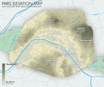
Elevation map of Paris' valleys and highest buttes (altitude in metric and imperial); also included: Paris' existing and defunct rivers and major and minor waterways. (http://en.wikipedia.org/wiki/User:ThePromenader#mediaviewer/File:Jms_paris_elevation_map_2012.jpg)
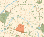
Green areas in Paris and the 14th arrondissement. (http://en.wikipedia.org/wiki/14th_arrondissement_of_Paris#mediaviewer/File:Paris_14e_arr_jms.gif)
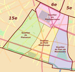
Neighborhoods within the 14th arrondissement. (http://www.travelfranceonline.com/paris-14th-district-14eme-arrondissement/ )


Analytical drawings
- Please use analytical drawing for visualising the conflicts/potentials of your site
- Analytical Drawings
- Your drawing.jpg
title
- Your drawing.jpg
your drawing
- Your drawing.jpg
your drawing
- Your drawing.jpg
your drawing
Green Infrastructure benefits for this site
Look again at the multiple benefits of green infrastructure - what could be achieved in your site and which are most relevant?
Potential for multifunctionality
Green infrastructure has typically multiple functions. What could be achieved for your site in this respect?
Projective drawings
- How would you like this case to change in the near future? (in 1-2 years)
- you may add a short explanation here
- And how could it look like in 10-15 years?
- you may add a short explanation here
- Projective Drawings
- Yourdrawing.jpg
projective drawing
- Yourdrawing.jpg
projective drawing
- Yourdrawing.jpg
projective drawing
- Yourdrawing.jpg
projective drawing
Summary and conclusion
- 100 words approx.
Image Gallery
Please add further images/photos here
- Image Gallery
- Yourimage.jpg
your image text
- Yourimage.jpg
your image text
- Yourimage.jpg
your image text
- Yourimage.jpg
your image text
- Yourimage.jpg
your image text
- Yourimage.jpg
your image text
- Yourimage.jpg
your image text
- Yourimage.jpg
your image text
References
- please add your references here
About categories: You can add more categories with this tag: "", add your categories