Green Infrastructure 2014 Working Group F - Abdali Bridge: Difference between revisions
No edit summary |
No edit summary |
||
| Line 219: | Line 219: | ||
<gallery caption="Projective Drawings" widths="250px" heights="250px" perrow="4"> | <gallery caption="Projective Drawings" widths="250px" heights="250px" perrow="4"> | ||
Image:Short_Term_Abdali_1_copy.jpg|Short Term Projection | Image:Short_Term_Abdali_1_copy.jpg|Short Term Projection | ||
Image: | Image:Short_Term_Abdali_2.jpg|Short Term Aerial View | ||
Image:Long_Term_Abdali_1.jpg|Long Term Projection | Image:Long_Term_Abdali_1.jpg|Long Term Projection | ||
Image:yourdrawing.jpg|projective drawing | Image:yourdrawing.jpg|projective drawing | ||
Revision as of 15:01, 26 November 2014
---> back to group page working group F
Implementing Green Infrastructure in the Abdali Bridge Area
| Name | Abdali Bridge | |
| Country | Jordan | |
| City | Amman | |
| Authors | Maroula Shami | |
 Bridge during Rain[1] | ||
|
| ||
Rationale: Why is this case interesting?
Due to climate change, Jordan has been experiencing a change in rainfall patterns. The current grey infrastructure is not capable of draining the storm-water properly as it has not been designed to receive such large quantities. Also, the fact that it is not maintained properly further amplifies the problem. It is therefore worth considering the introduction of a layer of green infrastructure which would assist the existing grey infrastructure to avoid flooding in the future.
The Abdali area underwent a radical change in the past years, the aim of which was to create a new downtown for the city of Amman. The massive mixed-used development project included the construction of residential and commercial buildings. Changes were made to the road network surrounding this project which included the construction of the Abdali Bridge. This bridge (with the roundabout below it) connects the Ministry of Interior Affairs circle (north), the Abdali project (north-east), the Abdali area (east), the Third Circle (south-east), the Fourth Circle (south), and the Shmesani area (west). During the heavy rainfall that Jordan has experienced in the beginning of November 2014, slight flooding occurred in this area, and it is speculated that an introduction of proper green infrastructure would prevent this problem from reoccurring in the future.
Author's perspective
Today, Amman is a highly urbanized city, which was sadly designed for the automobile and lacks a pedestrian, as well as cycling, transportation network. The only natural body that used to flow in the city in the Ras Al-Ain area (to the east of the chosen site) has dried a long time ago. Amman also lacks a properly designed and implemented green infrastructure. Although street trees are planted on all major roads, these cannot perform their role alone, and should work as a part of an extensive network of green infrastructure implemented in the city. The absence of this network is having adverse effects on stormwater management in the last couple of years. Due to Climate Change, Amman is experiencing instances of heavy rainfall as mentioned before. As a result, flooding has been occuring in the streets, especially in roads where bridges are present, as is the case with the newly constructed Abdali Bridge.
Landscape and/or urban context of the Abdali Bridge


Biogeography
Amman is situated on multiple hills, called Jabal(s) in arabic, which can be seen in the names of several areas like Jabal Amman, Jabal Al-Weibdeh, Jabal Al-Nadeef... etc. Originally, Amman was located on 7 hills (represented by the 7-pointed start on the Jordanian flag). The settlement on these hills, like many others, started next to a water body as these hills surrounded Wadi Ras Al-Ain which roughly translates into the valley from which the fountain springs. Since then, Amman has expanded westwards, despite the unevenness of the topography. Flat areas are a rarity in Amman, and before the automobile was used extensively, several staricases were used to connect the people. However, once the automobile became the most common mode of transportation, roads were constructed parallel to the topography of the hills in order to abide by the inclination guidelines stipulated for vehicular traffic. The altitude of Amman varies from 700-1100m above street level.
Since settlement in Abdali area has started a really long time ago, today there are no traces of what the area looked like before urbanization. There is no native vegetation. In fact, the only plants present in the area are those planted in private gardens or as street trees. There are no animals as well, and there is no available data on the habitats that existed in the area before it was urbanized. Today, the only animals that could be seen are stray cats (which are somewhat common in Amman), and birds that build nests in garden trees or rest on electricity lines.
Cultural Features
The Abdali area is one of the older parts of the city and contains several important religious and civic buildings. The Palace of Justice, Ministry of Education, King Abdullah I Mosque, Church of the Annunciation, and the Coptic Patriarchate are all located on Suleyman Al-Nabulsi Street. The Jordanian Parliament and House of Senate and Representatives is located on the King Hussein Street and in the same block as the Palace of Justice. The Abdali area has been chosen for a development project on a former military site to create the New Downtown.

- Points of Interest
![Palace of Justice: the major courthouse in Amman[4]](/images/thumb/4/4c/Palace_of_Justice.jpg/340px-Palace_of_Justice.jpg)
Palace of Justice: the major courthouse in Amman[4]
![Jordanian Parliament [5]](/images/thumb/3/3e/Parliament.jpg/433px-Parliament.jpg)
Jordanian Parliament [5]
![Coptic Patriarchate in Amman[6]](/images/thumb/e/eb/Coptic_Patriarchate.jpg/361px-Coptic_Patriarchate.jpg)
Coptic Patriarchate in Amman[6]
![Greek Orthodox Church of the Annunciation [7]](/images/thumb/8/84/Church_of_the_Annunciation.jpg/406px-Church_of_the_Annunciation.jpg)
Greek Orthodox Church of the Annunciation [7]
![Palace of Justice: the major courthouse in Amman[4]](/index.php?title=File:Palace_of_Justice.jpg)
![Jordanian Parliament [5]](/index.php?title=File:Parliament.jpg)
![Coptic Patriarchate in Amman[6]](/index.php?title=File:Coptic_Patriarchate.jpg)
![Greek Orthodox Church of the Annunciation [7]](/index.php?title=File:Church_of_the_Annunciation.jpg)

- King Abdullah I Mosque [9]
It is one of the monumental mosques in Amman and was built to commemorate King Abdullah the first in 1982. It is built on a 12 000 square meter land which was later expanded to 18 000 square meters. The mosque's major components are:
- central prayer hall: octagonal in shape and accommodates 3000 men
- Women's Prayer Hall: accommodates 500 women
- Conference Hall
- Library
- Qur'an Teaching School
- Islamic Museum
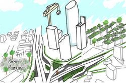
- The New Downtown [10]
![Abdali Master Plan [11]](/index.php?title=File:Abdali_Site_Plan.PNG)
![Abdali Boulevard [12]](/index.php?title=File:Abdali_Boulevard.PNG)
![Abdali Image [13]](/index.php?title=File:Abdali_Cover.PNG)
The Abdali development project covers a 384000 square meters area. It is a mixed-use development project which is composed of residential and commercial buildings in a pedestrian-friendly setting. It offers
- prestigious residential buildings (both serviced and unserviced)
- a central business district that attracts foreign investors
- a variety of leisure opportunities
- hotels
Pedestrians are kept in mind throughout the design of the entire project, but they can especially enjoy the Boulevard at the center which consists of 12 buildings (6 on either side) surrounding a 340 m pedestrian promenade. To make use of the slope in the site, this Boulevard is divided into 3 platforms that are connected by different means of vertical circulation to provide the visitors with a unique experience as they strolls through it. Overall, there are 60,000 square meters of pedestrian roads, piazzas and landscaped parks in the project.
The project aims at being sustainable, and that is applied by the implication of a grey-water collecting and treatment system, energy efficient heating and cooling provided by Jordan District Energy, and encouraging developers to attain LEED certification for their buildings.
Overall Character
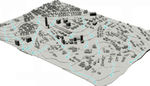
Amman Districts
![Density Map [14]](/images/thumb/6/6d/Density_Map.PNG/617px-Density_Map.PNG)
Density Map [14]

![Density Map [14]](/index.php?title=File:Density_Map.PNG)

Aside from the new development, the character of the Abdali area is similar to any neighborhood in Amman. Buildings are mostly constructed of stone and have a cubic form (with the exception of a few houses with pitched roofs). Houses are surrounded by gardens, the size of which depends on the land use category (residential categories stipulate minimum plot size and setbacks among other determinants). Roads can be divided into two categories; major and minor roads. The difference between the two is in street width and sidewalk width (which is dependent on the width of the street). Wherever width permits, planters are present on sidewalks and mid-road islands. Outdoor interaction among residents is limited to private settings (gardens) and the very few public parks which are mostly visited by children and their parents since they are the target users of these parks.
Due to the presence of the Palace of Justice in the vicinity, there is a large number of lawyers' office scattered around between homes in the residential areas as well as offices in general on the sides of major streets. Commercial functions are also mostly concentrated along major roads, except for small grocery stores which are built on plots that are categorized as residential. This implies that major roads of the area experience heavy traffic during working hours, a problem which was partially solved by the construction of the Abdali bridge. Another problem is the insufficient number of parking spaces, since most Jordanians area accustomed to drive their car to most places in the absence of an efficient public transportation system.
History and Dynamics

Jordan[16]
Being located in the heart of the Middle East, and on several trade routes, Jordan had a strategic location throughout history which explains why it has hosted many different civilizations; Egyptians, Assyrians, Babylonians, Hittites, Greeks, Romans, Arabs, Turks and Crusaders. One of the world's first cities Al-Beidha was situated in Jordan, close to modern day Petra. During the Iron Age, three kingdoms emerged in Jordan; the Edomites, the Moabites, and the Ammonites.
Amman[17]
Settlement in Amman began as early as the Bronze Age, and it was chosen as the capital of the Ammonites Kingdom during the Iron Age but was know as Rabbath Ammon. Amman, since then, has witnessed a sequence of civilizations; Assyrians, Babylonians, Persians. It was renamed Philadelphia during the Hellenistic Period, and was ruled by the Ptolemies (301-198BC) followed by the Seleucids (198-63BC). During the Roman reign,still know as Philadelphia, was part of the Decapolis League. The Roman period was followed by the Byzantine period which ended in the early 7th century and after which the Umayyad Empire began. Since then, Jordan has been ruled by Muslim Caliphates; the Abbasids, the Fatimids, the Ayyubid and Mamluks, and finally the Ottomans. The Ottoman reign lasted for four centuries (1516-1918 AD), and ended with the Arab Revolt which led to the establishment of the Emirate of Transjordan which is the modern day Hashemite Kingdom of Jordan with Amman as its capital.
- History of the Site
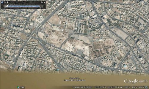
2003
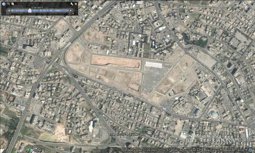
2007
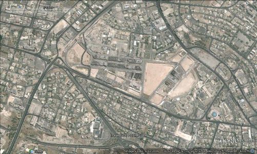
2009
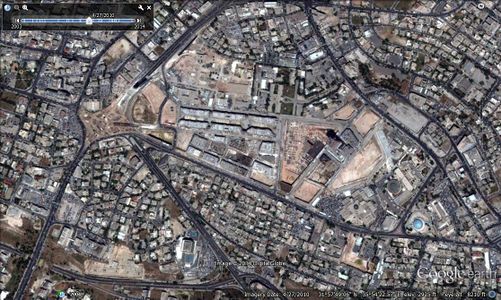
2010
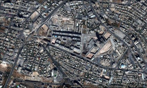
2011
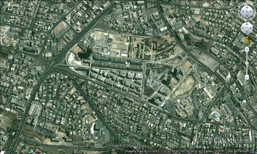
2014
Areas Experiencing Major Changes


The images above show that the only major changes to the Abdali area in the past 10 years have been the development project and the road network that surrounds it. The Abdali area had very few empty plots of land as far back as the year 2000. Expansion by demolishing old low-rise building and replacing them with ones that have more floors has started occurring since the beginning of the development project,

however, these occurrences are limited in number and restricted to the buildings across the street from it. This was done to extract the maximum value of land by imitating the high-rise buildings within the project. Sadly, no attempts at imitating the attention to pedestrians and green areas have been made in the surrounding neighborhoods.
Friday Market
Since 1988, a Thursday night- Friday morning Flee market used to take place on a plot of land which had been a former bus stop for intercity buses in the Abdali area. The flee market was visited by a lot of customers every weekend, especially those leaving the mosque after Friday prayer. The flee market used to sell different things ranging from secondhand clothes to fruits and vegetables. In the beginning of October 2014, the flee market has been moved to the Ras Al-Ain area. This has double benefits, on the one hand the site in Abdali will be used as a much-needed parking for automobiles connected to a new public transportation mode which would carry passengers around the Abdali and Shmeisani area. On the other hand, the new site chosen for the flee market has adequate parking and would thus not cause the traffic congestion which is associated with the market in the Abdali location.
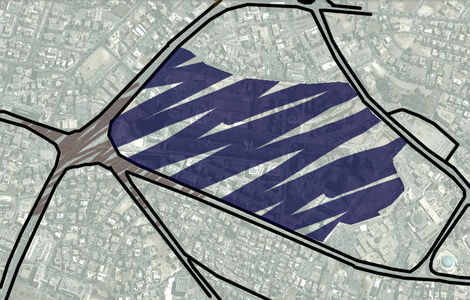
Analytical drawings
- Analytical Drawings
SWOT Analysis
Natural Drainage according to Topography
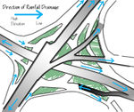
Rain Drainage from the Bridge
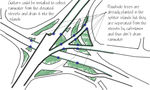
Existing Splitter Islands
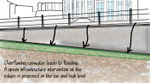
Overflow Problem


Green Infrastructure benefits for this site
- Environmental Benefits
The environmental benefits gained from the use of green infrastructure are not restricted to flood alleviation (despite its importance in the area). The air quality would improve as a result of the "greening" activities which is associated with the production of more oxygen and carbon sequestration. The collected storm-water would be filtered making it pollutant-free and thus suitable for groundwater recharging. Added to that, vegetation would reduce the heat island effect resultant from large areas of impervious covering which is essential in an area with a hot climate like Jordan.
- Economic Benefits
Grey infrastructure is typically expensive to install and to maintain. One of its majors downfalls is that it degrades with age, unlike green infrastructure which actually improves in efficiency as time passes by. Grey infrastructure also has some operational costs associated with water pumping which requires energy, while the green alternative does not consume any energy. An additional benefit is the increase of property values in the area.
- Social Benefits
Improved air quality would translate into better health for the residents of the area. The vegetation planted for grey infrastructure would also enhance the aesthetic value and thus have a positive psychological impact.
- Enhanced Connectivity
By implementing a layer of green infrastructure, sidewalks in the area would be redesigned which would give the opportunity to convert the streets into pedestrian-friendly street. Also, this may result in considering the introduction of cycling pathways in the areas, thus providing residents with a wider variety of transportation modes.
Potential for multifunctionality
- At the Street Level
Street networks are normally multifunctional in their nature as they carry traffic of different types, however, this is not the case in the Abdali area. Existing sidewalks do not encourage pedestrians to go out on walks, and are only used by people due to a need rather than an opportunity. The enhancement of the street structure, by the addition of properly designed sidewalks with bio-swales, would create an interest in the people to use them, and will be reflected on the health of the citizens due to exercise. The implicit proper rainwater drainage would mean that citizens would be able to use them year-round, even during rain events. The introduction of a rain garden(s), would also enhance the visual appearance of the area as a whole, and is translated into an increase in the citizens' access to green spaces.
- At the Skyline Level
Rooftops in Amman, despite being flat, are rarely used by the owners for leisure. Usually, water tanks, satellite dishes, and other "service" elements are placed there which creates an unpleasant skyline. By converting the roofs of residential and commercial buildings to green-roofs, an enhancement to the skyline occurs, along with an increase in the open spaces that are accessible to the residents or workers in the building. This also means that the footprint of buildings would be reduced, due to the transformation of the surface of the roof from impervious to water-permeable.
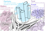
Projective drawings
- Short Term Projection (1-2 Years)
- In the coming two years, significant progress will have taken place in the Abdali Project development, which could mean the appearance of green roofs and an appealing skyline. "Greening" could also be seen in the sidewalks which will be fitted with bio-swales and encounter heavy foot-traffic.
- Long Term Projection (10-15 Years)
- A complete transformation of the area could occur, along with the completion of the development projects. The buildings on the opposite side of the project, that were intended to be rebuilt, would be rebuilt while considering the amount of impervious surfaces created. Rainwater collection techniques would be implemented by all of the buildings in the vicinity. The plants on the green roofs and in the bio-swales and rain gardens would have grown creating an aesthetically pleasing environment.
- Projective Drawings
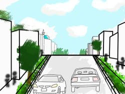
Short Term Projection
Short Term Aerial View
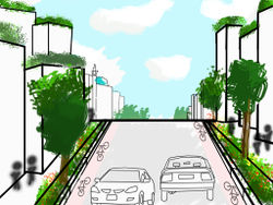
Long Term Projection
- Yourdrawing.jpg
projective drawing


Summary and conclusion
Since the Abdali area is already undergoing a redevelopment process, it is strongly advised to introduce a layer of green infrastructure at this stage due to its feasibility and the multitude of benefits which could be gained by it. The development project itself already has sustainability considerations taken into account, but those could be further enhanced by the application of green infrastructure elements (green roofs, bioswales, rain gardens). The area across the street from the project is expected to undergo a transformation as well, in the long term future, and affords the possibility of "greening" . The Suleyman Al-Nabulsi street (which lies between these two areas) hosts many important buildings (Palace of Jutsice, Iconic Mosque, Governmental Functions) so the improvement to this street's structure would make it an exemplary street that reflects a positive image of the city of Amman.
References
- ↑ Abdali Bridge. Digital image. Khaberni Page on Facebook. N.p., 3 Nov. 2014. Web. 6 Nov. 2014. <https://fbcdn-sphotos-e-a.akamaihd.net/hphotos-ak-xap1/v/t1.0-9/11568_10152793390865979_4939510335147356565_n.jpg?oh=d2465e12fa3205d7ef013958f0aa2bc4&oe=54E738E1&__gda__=1423527848_68a67ff9dc320ae7c6c4f9c4119106f1>.
- ↑ Atalla, Lama, Dina Rabadi, and Zeinab Zareer. "Topography 3D." Unveiling the Antipodes Graduation Project Thesis. Amman:2014. 10. Print.
- ↑ Atalla, Lama, Dina Rabadi, and Zeinab Zareer. "Topography." Unveiling the Antipodes Graduation Project Thesis. Amman:2014. 36. Print.
- ↑ Palace of Justice, Jordan. Digital image. All of Jordan. N.p., 09 Mar. 2011. Web. 6 Nov. 2014. <http://www.hkjtoday.com/uploads/thumbs_518/c/7/c74469f8b63af01508252fac58103cc0a6ac90d4.jpg?>.
- ↑ Jordanian Parliament. Digital image. The Jordan Times. The Jordan Times, 30 Sept. 2012. Web. 8 Nov. 2014. <http://jordantimes.com/parliament-session-postponed-in-prelude-to-polls>.
- ↑ Coptic Patriarchate in Amman. Digital image. Virtual Tourist. Mikey E, 22 Nov. 2012. Web. 7 Nov. 2014. <http://www.virtualtourist.com/travel/Middle_East/Jordan/Amman-1800107/Things_To_Do-Amman-Churches-BR-1.html>.
- ↑ Church of the Annunciation. Digital image. Albisharah Church Page on Facebook. N.p., 24 Dec. 2012. Web. <https://www.facebook.com/289706634474342/photos/a.304689716309367.64602.289706634474342/304692462975759/?type=3&theater>.
- ↑ King Abdullah I Mosque. Digital image. Exploring Tourism Jordan. N.p., n.d. Web. 6 Nov. 2014. <http://www.travelojordan.com/destinations/king-abdullah-mosque/#.VFv1WMnBok4>.
- ↑ "معالم اسلامية : مسجد الملك عبد الله الأول." جريدة الدستور. Addustoor Newspaper, 20 July 2013. Web. 06 Nov. 2014. <http://www.addustour.com/16917/%D9%85%D8%B9%D8%A7%D9%84%D9%85+%D8%A7%D8%B3%D9%84%D8%A7%D9%85%D9%8A%D8%A9+%3A+%D9%85%D8%B3%D8%AC%D8%AF+%D8%A7%D9%84%D9%85%D9%84%D9%83+%D8%B9%D8%A8%D8%AF+%D8%A7%D9%84%D9%84%D9%87+%D8%A7%D9%84%D8%A3%D9%88%D9%84.html>.
- ↑ Abdali Investment and Development PSC. Abdali Brochure. Amman: Abdali Investment and Development PSC, n.d. Abdali. Web. 13 Nov. 2014. <http://www.abdali.jo/pdf/brochure.pdf>.
- ↑ "Abdali Master Plan." Abdali. N.p., n.d. Web. 13 Nov. 2014. <http://www.abdali.jo/index.php?r=site/index>.
- ↑ Abdali Boulevard. Digital image. Abdali. Abdali Investment and Development PSC. Web. 13 Nov. 2014. <http://www.abdali.jo/pdf/brochure.pdf>.
- ↑ Brochure Cover Image. Digital image. Abdali. Abdali Investment and Development PSC. Web. 13 Nov. 2014. <http://www.abdali.jo/pdf/brochure.pdf>.
- ↑ Atalla, Lama, Dina Rabadi, and Zeinab Zareer. "Density Map." Unveiling the Antipodes Graduation Project Thesis. Amman:2014. 42. Print.
- ↑ Abzakh, Shatha, Rawand Obaidat, and Batool Al-Disi. "Amman Timeline." Pixels of Fordism Graduation Project Thesis. 2014. 31. Print.
- ↑ "Jordan." Lonely Planet. Web. 15 Nov. 2014. <http://www.lonelyplanet.com/jordan/history>.
- ↑ "History - The Hashemite Kingdom of Jordan." The Hashemite Kingdom of Jordan. Web. 12 Nov. 2014. <http://www.kinghussein.gov.jo/history.html>.
- ↑ Freij, Muath. Abdali Friday Market. Digital image. The Jordan Times. The Jordan Times, 7 Oct. 2014. Web. 13 Nov. 2014. <http://jordantimes.com/vendors-say-moving-abdali-market-bad-for-business>.
About categories: You can add more categories with this tag: "", add your categories