Collaborative Design Planting Design Working Group 24: Difference between revisions
| Line 44: | Line 44: | ||
The Monastery and related palaces, mannors and lands inside this historical territory include some of the most relevant renacentist and neoclassical gardens in Spain and the landscape has been an important issue since Philipp II, who was a passionated lover of Nature and gardens, organising mayor aforestations in the mountains in different parts of Spain, and creating gardens and orchards in all his mayor palaces and residencies. Gregorio de los Ríos, one of his main gardners, published in 1592 one of the first historical garden treaties in Europe: [http://www.projetsdepaysage.fr/fr/gregorio_de_los_rios_at_the_casa_del_campo_ ''Agricultura de Jardines'']. Among other known king's gardners were the monk Marc de Orriols (Marcos de Cardona), Jerónimo de Algora (Italian), Juan and Francisco Holvecq (Flemish) and architects as Juan de Toledo and Juan de Herrera planned gardens, as well. | The Monastery and related palaces, mannors and lands inside this historical territory include some of the most relevant renacentist and neoclassical gardens in Spain and the landscape has been an important issue since Philipp II, who was a passionated lover of Nature and gardens, organising mayor aforestations in the mountains in different parts of Spain, and creating gardens and orchards in all his mayor palaces and residencies. Gregorio de los Ríos, one of his main gardners, published in 1592 one of the first historical garden treaties in Europe: [http://www.projetsdepaysage.fr/fr/gregorio_de_los_rios_at_the_casa_del_campo_ ''Agricultura de Jardines'']. Among other known king's gardners were the monk Marc de Orriols (Marcos de Cardona), Jerónimo de Algora (Italian), Juan and Francisco Holvecq (Flemish) and architects as Juan de Toledo and Juan de Herrera planned gardens, as well. | ||
In 1961 a part of it, the Mount Abantos and La Herrería oak | In 1961 a part of it, the Mount Abantos and La Herrería oak and sweet chestnuts Forest, got the protection figure of Picturesque Landscape (15.39 sq.Km). | ||
The UNESCO entitled the Royal Monastery of San Lorenzo with the Historical Site and Natural Surroundings of El Escorial as [http://whc.unesco.org/en/tentativelists/1026/ World Heritage Site] in 1984; nevertheless, part of the territory had not a real protection and underwent several contructions in the following decades, which has been strongly contested by local and regional ecologist organisations[http://entornoescorial.blogspot.com.es]. In 1995 | The UNESCO entitled the Royal Monastery of San Lorenzo with the Historical Site and Natural Surroundings of El Escorial as [http://whc.unesco.org/en/tentativelists/1026/ World Heritage Site] in 1984; nevertheless, part of the territory had not a real protection and underwent several contructions in the following decades, which has been strongly contested by local and regional ecologist organisations[http://entornoescorial.blogspot.com.es]. In 1995 La Herrería oaks, maple, ash-trees and sweet chestnuts forest was declared a Forest of Special Ecological Interest. In 2006 the Regional Government of Madrid entitled the Royal Wall and the whole land, forests, archeological settlements, monuments and gardens within, as Cultural Protected Item (BIC) as Historic Territory. The place is also part of the European Nature 2000 habitat of the Guadarrama river and is considered a part of the landscape and environmetal buffer zones for the recently aprobed National Park of the Sierra de Guadarrama Summits. | ||
'''Nature''' [http://www.sanlorenzoturismo.org/ingles/entorno_natural/flora.asp] | '''Nature''' [http://www.sanlorenzoturismo.org/ingles/entorno_natural/flora.asp] | ||
Revision as of 16:23, 5 February 2014
---> back to group page working group 24
Landscape Management at the Historical Site of El Escorial (Spain)
| Name | Landscape Management of the historical Cerca Real (Royal Wall) Territory at El Escorial | |||||||||||
| Location | El Escorial (Madrid) | |||||||||||
| Country | Spain | |||||||||||
| Authors | Francisco Felipe-Martínez, Le Trang Nguyen, Irina Slobozeanu | |||||||||||

| ||||||||||||
| {{#widget:GoogleMaps | width=300 | height=200 | lat=40.5956 | lng=-4.1658 | zoom=11 | centermarker=yes | maptypecontrol=yes | overviewmapcontrol=yes | largemapcontrol=yes | scalecontrol=yes
}} | ||
Landscape and/or urban context of your case
- Biogeography, cultural features, overall character, history and dynamics
History
The territory has been habitated at least since the Eneolithic time (Copper Age). There is an old settlement of that time in the slopes of the Machotas mountains, as well as El Dehesón archeological site, related to the megalithic tombs of Dolmen del Rincón and burial state of Canto de Castrejón, among other megalithic tombs and findings on the surroundings. It was found a civitas from the Roman time near the Guadarrama river banks, unfar from the today ruins of Monesterio (a Middle Age village and later palace of Philipp II), as well as old Roman roads, and a late Roman hostel was excavated recently at the neighbour village of Collado Mediano. The old Roman roads where used later during the Visigothic and Arab times, although the Hispanoarabs built new roads crossing the mountains.
During the Arab rule of part of the Iberian Peninsula in the early Middle Age there were some scattered Mozarab (christians living in the muslim ruled territories) small villages in this place. The region was later taken by the knights and settlers from Segovia, getting importance the villages of El Escorial and Navalquejigo, among other smaller places. During the late Middle Age several palaces and towers were built by landlords and kings in the area, as El Campillo, which later were bought, renovated and adapted by Philipp II. Before the Renaissance the economy was based on extensive cattling and family scale agriculture.
In the XVIth. Century, when the Royal Monastery of St. Lawrence at El Escorial was built by Philipp II (the contruction of the 4 Ha building on granite took from 1563 to 1584) the same king decided to enclose the whole Monastery lands and related territories, as well as several already existing or new constructed palaces and mannors, by a 55 km long granite and gneis stone wall (Gran Cerca or Pared Real). It was renovated and enlarged in 1793. The Monastery and related palaces, mannors and lands inside this historical territory include some of the most relevant renacentist and neoclassical gardens in Spain and the landscape has been an important issue since Philipp II, who was a passionated lover of Nature and gardens, organising mayor aforestations in the mountains in different parts of Spain, and creating gardens and orchards in all his mayor palaces and residencies. Gregorio de los Ríos, one of his main gardners, published in 1592 one of the first historical garden treaties in Europe: Agricultura de Jardines. Among other known king's gardners were the monk Marc de Orriols (Marcos de Cardona), Jerónimo de Algora (Italian), Juan and Francisco Holvecq (Flemish) and architects as Juan de Toledo and Juan de Herrera planned gardens, as well.
In 1961 a part of it, the Mount Abantos and La Herrería oak and sweet chestnuts Forest, got the protection figure of Picturesque Landscape (15.39 sq.Km). The UNESCO entitled the Royal Monastery of San Lorenzo with the Historical Site and Natural Surroundings of El Escorial as World Heritage Site in 1984; nevertheless, part of the territory had not a real protection and underwent several contructions in the following decades, which has been strongly contested by local and regional ecologist organisations[1]. In 1995 La Herrería oaks, maple, ash-trees and sweet chestnuts forest was declared a Forest of Special Ecological Interest. In 2006 the Regional Government of Madrid entitled the Royal Wall and the whole land, forests, archeological settlements, monuments and gardens within, as Cultural Protected Item (BIC) as Historic Territory. The place is also part of the European Nature 2000 habitat of the Guadarrama river and is considered a part of the landscape and environmetal buffer zones for the recently aprobed National Park of the Sierra de Guadarrama Summits.
Nature [2]
The territory climbs from the 800 to the 1753 m above the sea (Abantos summit) and includes a wide range of biotops, from wet endorheic areas and lacoons ('lavajos' with Potamogeton natans, Ranunculus peltatus and other water plants) in the lowerlands to shrubs (Citisus oromediterraneus aka C. purgans, Genista cinaerescens, grasspastures (Nardus stricta, Deschampsia flexuosa) in the upper part of the mountains. The mountains slopes are characterised by pine forests of several indigenous species (from the lower to the higher places: Pinus pinea, P. nigra sp. salzmannii v. hispanica, P. pinaster, P. sylvestris sp. iberica [3] including several alloctonous exemplars and groves of P. muga, P. radiata, P. jeffreyi, P. sabiniana and P. culterii) and the indigenous species growing in assocition with them as Juniperus (J. oxycedrus, J. communis, J. alpina nana), very old yew trees (Taxus baccata) and some other exoticals (Larix decidua, Cedrus atlantica, Cedrus libani, Picea abies, Pseudotsuga menziesii, Cupressus × leylandii, all of them planted by the Forestry Engineering School between 1888 and 1914) and decidious trees as Sorbus acucuparia, Amelanchier ovalis,Ulmus laevis, Ulmus nigra and most of the typical of the oaks forest, entering the pine forests from the surrondigss, as well as Betula alba sp. celtiberica, together with aforested beechtrees (Fagus sylvatica), maples (Acer pseudoplatanus and A. platanoides) and oaks (Quercus robur) silver fir (Abies alba) all from North Spain and pinsapo fir trees (Abies pinsapo) from the South.
The lower mountains bear mature forests of Pyrenean oak (Quercus pyrenaica) [4] with a rich biodiversity, including a relictics forest of sweet chesnuts (Castanea sativa), as well as Acer monspessulanum, Corylus avellana, Malus sylvestris, Pyrus bourgaeana, Prunus avium, Prunus spinosa, Rhamnus cathartica, Quercus faginea, Fraxinus angustifolia. In the lower lands ther are 'dehesas', open forests and groves of Quercus ilex sp. ballota and Fraxinus angustifolia, sharing the land with pastures of the Poa pratensis and Trifolium subterraneum association (priority habitat of the UE Habitat Directive) together with a rich grass and herbs biodiversity. There are as well 'bocage' structures with mainly Pyrenean oaks, local ashtrees, hiproses, sloes and hawthorns.
Landscape
This area of study is one of the most relevant natural and cultural landscapes in Central Spain. It takes the form of an valley from San Benito summit and the Cruz Verde mountain pass, between mountains chains of Machotas souhtwards and of sierra de Malagón (Risco Alto, Abantos, San Juan, La Naranjera) northeastwards. The valley begins very narrow and opens gradually to the plateaus at the foot of the mountains.
This landscape is the result of long term interactions of the people living there, from the seduction caused on the Spanish kings during the Renaissance, Barock and Neoclasicism by the beauty of the picturesque nature scenary, to a kind of Romantic search of a lost splendour. It is being also a place of disrumption and tensions between Nature's wilderness and human interesses and use of land and natural resources.
The reshaping of the landscape sometimes had possitive effects, as the preservations of forests, the creation of gardens, or even created sinergies, as the sustainable 'dehesas' (open forest of scattered trees and grazinglands, which allowed the conservation of trees and forest stands while the pastures were profited by the cattle, and the periodically pruned wood for heating), or the 'lavajos' (small seasonal or permanent lacoons, somEtimes natural, sometimes manmade profiting the endorheic humid areas where the water keeps, which allowed the conservations of rare water plants and asociations, as well and endemic fishes, amphibia and birds). Bur there were also negative effects, as the lost of mountain forest in order to get wood for contruction, heating and small industry and crafts production, or more recently since the end of the 19th Century, the growth of the once small villages and settlements, process which has been accelerated in the lats half century with a speculative building fever at costs of landscape quality.
The Landscape Atlas of Madrid [5] defines four landscape units in the zone:
G03 Valle de los Caídos, of 3356 Ha. Average altitude: 1317 m. Constituted by the physiograhic elements: upper sierra slopes and mountain water courses, gneiss and granite rocks formations. Vegetation: mountain pasture and shrubs, pine forests of Pinus sylsvestris, P. pinaster and other trees. Main water courses: El Boquerón, Las Chorreras. Lakes and reservoirs: El Boquerón.
G04 El Campillo, 2960 Ha. Average altitude 973 m Phyisiographic elements: valley Valle de los Caídos, lower parts of the mountains ad valleys, mountain slopes, climbing plateaus ('rampas'), foothills, , depressions ('navas'). Xerophytic pastures and grasslands , holm oak and ash tree groves and open forests ('dehesas'). Water courses: El Barrancón, Guadarrama, Loco, Pradovera, El Agua, Loyón, Guatel Primero, Guatel Segundo. Small endorreic lacoons ('lavajos') scatered on the lower parts.
G06 El Escorial 3713 Ha. Average altitude: 1143 m. Urban structures: El Escorial, San Lorenzo de El Escorial. Physiographic elements: mountain slopes, step slopes, foothills, climbing plateaus ('rampas'), depressions ('navas'). Vegetation: Xerophytic pastures and grasslands, shrubs, Pine foreMatorrales de leguminosas; Scots pine forests, Pyrenean oak forests. Water courses: La Torrecilla, El Batán, El Valle, Los Castaños, El Helechal, El Romeral, Los Gallegos, Las Cebadillas, La Cruz, El Barrancón. Reservoirs: Embalse El Batán, Embalse El Romeral (16, 18 and 19th. Centuries), Presa El Infante (18th. Century), El Castañar.
G07 Embalse de Valmayor 6277 Ha. Average altitude: 874 m. Urban setlements of El Arcor, Paraíso, Parque de las Infantas, Pinosol, Los Arroyos and old village Navaquejigo. Physiographic elements: Mountain foot, foothills, step slopes, depressions ('navas') and endorreic laoons ('lavajos'). Vegetation: Xerophytic pasteres and grasslands, open hom oak foress ('dehesas'), mature holm oak and ash tres forests, holm oak shrubs, open Pyrenean forests. Water courses: river Aulencia, La Cañada, El Batán, La Fuente del Tejadillo, El Tercio. Lakes and water reservoirs: embalse Los Arroyos, Embalse Valmayor, La Granjilla I, La Granjilla II, La Granjilla III (these three built 16 th. Century by Duch dyke engineer Jansen under comission of Philipp II as part of the gardens complex La Granjilla).
La Herrería Forest, Abantos and Machotas mountains' scenery
Historical and relevant gardens.
Gardens of the Royal Monastery San lorenzo de EL Escorial (began by Marc de Orriols, Marcos de Cardona, gardener of Charles V and Philipp II, and soon later by Holvecq and Algora, following the architects plannig by Juan de Toledo and Juan de Herrera): King and Queen Gardens. Monk Orchards. Monks garden. 16 th, partly reformed 18th Century.
La Granjilla or Fresneda Gardens (Including reservoirs made by the Dutch dyke engineer Jansen) 16th Century.
El Castañar. 16th Century.
Casita del Príncipe Gardens, park and orchards. By architect Juan de Villanueva. 18th Century.
Casita del Infante Gardens. By Juan de Villanueva. 18th Century. 19th Century enlargement. Restoration by Landscape Architect and Gardens Historian Xavier de Winthuysen in the 1940's.
Parque de Los Alamillos (University Park or Park Carrero). 19th and 20th Centuries.
Arboretum Luis Ceballos. Late 20th Century.
- Maps
-
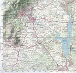 Topographic map
 -
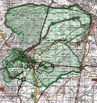
 Royal Wall Historical territory Cultural Protection map
 -
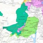
 Location of main monuments, gardens and cultural items
 -
 Protected Landscape & Historic Territory
 -
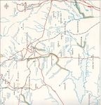 Water streams, rivers, reservoris and lacoons


- Images
-
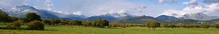
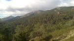 The mountain ridge southwestwards
 -
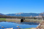 The mountains from the renacentist reservoirs of la Ganjilla.
 -
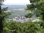 The Monastery and the dehesas behind seen from Abantos
 -
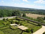 The King's Garden at the Monastery El Escorial


-
 Holm oak dehesas beneath the Sierra de Guadarrama

What are the objectives of your design?
Please give a short written argumentation (not more than 150 words). It is ok if you have different or even contradicting objectives within your group. Just make it explicit at the beginning of your process
The objective is to provide framelines and ideas for a Landscape estrategic planning on this sensible zone, which would integrate nature, wilderness, cultural estructures and historical gardens, prospecting a whole concept for the environmental preservation and future landscape management, challenged by the urban growth tensions and interesses. Main tools for attainning these goals are the implementation of a naturalistic, restaurative concept of Planting Design, the public participation and Environmental Education programs. Or ¿how to integrate all that into an environmentaly sustainable project forwards?.
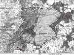
Analytical drawings
Please add four analytical sketches/drawings (or montages/schemes) of your case. Every group member needs to contribute at least one drawing.
- Analytical Drawings
-
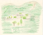 View from the valley to the summits
 -
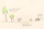
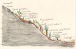 Bioclimatic succession.jpg
 -
 Lavajos and Ashtree groves in the plain


Projective drawings
Please add four projective sketches/drawings (or montages/schemes), of course with an emphasis on planting design/vegetation aspects. Every group member needs to contribute at least one drawing representing his/her individual ideas.
- Projective Drawings
-
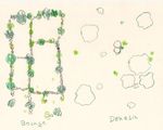 Bocage and Dehesa structures restoration
 -
 Reforesting the burnt forest with oaks
 -
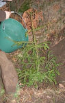 Taxus baccata


Design Synthesis
Our proposal is an integrative strategy for the landscape management in the area of this study case, which includes as main tool plantig design concepts. The place is at the same time relevant cultural, historic and natural site, all in one, being, as well, a reference for the history of garden art in Spain since the second half of the 16th and until the early 20th Centuries, an also a mayor reference for the Forest Engineering in Spain. Our group choice, following the issues treated in this Seminar, decided, thus, to propose a concept of Planting Design in a landscape management scale, taking from the still existing natural forests and in general vegetal stands and improving the landscape mosaicity. Hence, we propose an Integrated Landscape Management Strategy with the following mainlines:
- Protection of the existing land.Prohibition of any kind of deforestation.
-Planting Design to foster Landscape & vegetation recovery
-Profit the strong historical background in relation to Nature, Landscape, Gardens
- Development and rehabilitation of the damaged area, vegetation recovery, natural spaces conectivity.
- Creation of protective barriers, green curtains of trees.
- Preventing urban development in the area and if they allow this, urbanization is under severe conditions.
- Use the site as an interactive domain to connect nature and people.
- Create connection solutions between ecological zones and human activities.
- Increase People Environmental Education and activities as involvement in replanting projects for deforested areas.
- Development of sustainable tourism-ecological systems, implementation of eco-accommodation and other facilites for tourists, as well as increasing and enlarging the existing interpretative routes and other public use resources, following the advises of the Florence Treaty.
With programmes as:
- Reorganise the tesserae of the open field lanscape by restoring the 'dehesas' (open forests) and 'bocages' (pastures enclosed between stone fences with trees and shrubs all along its boundaries, mainly oaks and ashtrees, hiproses, hawthorns, sloes... which nurture the wildlife), sharing the space with pasture and grazinglands.
- Restore the lost 'lavajos' lacoons and their water flora and zoa and improve the many others them still existing.
- Aforestation the missing parts of the forest with the vegetal associations of the climacic trees species on the according ecosystem in each case, focusing on the endangered species of trees and plants and those of particular lanscape interest. The Planting Design should follow scattered, random patterns as to imitate the natural growth of forest trees. Pregnant landmarks of the landscape, as particular granite or gneiss rocks formations, should be respected and their view not covered by the plantations, and so for cultural contructions which maintain a link with the non-destructive human interactions on the landscape (i.e. the granite stone contructions serving to conduce the water from the mountain tops to the Monastery in the lower mountain slopes). The forest management and plantings/aforestations should follow Landscape Architecture concepts (not usual in Forestry...), not only Forestry Engineering, so that the aforestation and forest stands and maintenance would enrich very much the Landscape Quality in the long term.
- A strategy to integrate the more modern residetial settlement and urban developments, by means of a kind of updated concept of green achitecture as treillages and palisandes: vegetal screens inspired in the tall trees used in some of the historical gardens (Sequoiadendrum giganteum, Cedrus libani, Cedrus deodara, Cedrus atlantica, Abies pinsapo, Abies normanniana, Pinus pinea, Pinus nigra, Pinus sylvestris, Pinus sabiniana, Pinus culteri...) both indigenous and exotical. Vertical gardens and greening platforms and roofs in strategic places, with species adapted to the climate.
- Green belts profitting the empty spaces between recent residential areas, creating a cotinuous of trees, shrubs and grasses, combining locations with mainly ornamental gardens species and maybe experimental creation of particular species of trees for concrete zones) and other more naturalised locations, let to their own natural dynamic. The one or the other case and their different possibilites had to be studied carefully in each location.
- Planting indigenous trees and associated shrubs where they are lost and eroded locations.
- Restoring free standing stone walls (without mortar) and the associated bocage of oaks, ashtrees, hiproses, hawthorns, sloes, spindle trees, buckthorns, dogwoods... which are natural, have different flowering in Spring and rich colorations in Automn; many of those plants also nurture the fauna.
- Recover and restaurate the historical gardens with the species which have been used in them in the differente centuries and styles, including indigenous and exotical, aloctonous plants, and creating new gardens with contemporay landscape concepts on the missing places (ie, naturalistic design, ecological succession... as we have seen in several Seminar sesions) which should be in harmony and or in harmonic contrast dialogue with the already existing historical gardens.
- Restore and maintain the old orchards of pear, apple, plums, cherries, almonds, walnuts, quinces.
- Restore the ancient roads and pathways which once were sided by kms long elm trees rows, now dissapeared, but which could be recover with new Elm Disease-resistant clones of indigenous Ulmus nigra recently developped by the INIA research institut in Madrid.
Please analyse the individual approaches presented so far and evaluate their strengths and weaknesses (you may use the SWOTanalysis model). Try to create a synthesis and represent it with a plan and some sketches. You can still use drawings/sketches.
- Design Synthesis Drawings
-
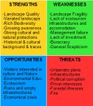 SWOT Analysis
 -
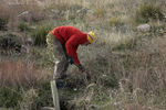
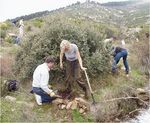 Citizens reforesting the burnt mountain forest


Summary of the collaborative process
Please reflect on your collaborative design process. Which potentials have you encountered? What was most difficult? What does collaborative design mean for you? (approx 150 words). In has been very instructive to see thesame facts and situations with someoneother's aproaches andperspectives. There were interesting coincidences, ie, in giving great importance to the population involment and direct particpation in landscape preservation, resoration and management, plantation etc. The most complicated was to cope with the privat schedules each of us had in other activities as work, studies, family... But it has been a great opportunity to collaborate with others.
Image Gallery
You may add a series of images/photos in addition to the sketches/drawings
- Image Gallery
References
* Please make sure that you give proper references of all external resources used.
* Do not use images of which you do not hold the copyright.
* Please add internet links to other resources if necessary.
External links
Nature[6] Historical Heritage[7] Royal Monastery of El Escorial[8] Monastery[9] Casita del Príncipe Palace, Gardens and Orchards[10] Casita del Príncipe[11] Casita del Príncipe Palace, Gardens, Orchards and Parc (extensive, in Spanish)[12] Casita del Infante Palace[13] Casita del Infante Gardens[14] La Fresneda[15] Arboreto Luis Ceballos[16]
About categories: You can add more categories with this tag: "", add your categories