River Lagan: Difference between revisions
Jump to navigation
Jump to search
| Line 121: | Line 121: | ||
<gallery caption=" " widths="150px" heights="150px" perrow="5"> | <gallery caption=" " widths="150px" heights="150px" perrow="5"> | ||
Image: | Image:IMG_4110_small.png|your image text | ||
Image: | Image:IMG_4111_small.png|your image text | ||
Image: | Image:IMG_4115_small.png|your image text | ||
Image: | Image:IMG_4122_small.png|your image text | ||
Image: | Image:IMG_4123_small.png|your image text | ||
Image: | Image:IMG_4123_small.png|your image text | ||
Image: | Image:IMG_4130_small.png|your image text | ||
Image: | Image:IMG_4134_small.png|your image text | ||
Image: | Image:IMG_4148_small.png|your image text | ||
Image:yourimage.jpg|your image text | Image:yourimage.jpg|your image text | ||
</gallery> | </gallery> | ||
Revision as of 04:06, 15 January 2009
Connectivity and the River Lagan, Belfast, Northern Ireland
Rationale: Why is this case study interesting?
- Note: this case study is for my terminal thesis project, which is not yet complete. So, descriptions of its success, cost, etc cannot yet take place.
- The River Lagan runs through the center of Belfast, the largest city in Northern Ireland, with a population of just under 300,000 in the city. About 580,000 people live in the greater metro area, which includes the city of Lisburn and the large town of Bangor.[1] The city was located strategically at the mouth of the Lagan and has been a port city for its entire existence. The land use along the river was formerly a mix of residential and industrial, but now the industry is for the most part gone. Connectivity around the river is poor and, although there are many amenities located along the river, they are not connected to each other well, either physically or visually. In addition, the river has the potential to serve as a greenspace and ecosystem for many species of birds, fish, etc, especially now as there is currently a restoration project underway to clean the river. So, part two of my project is to design habitats along the river, within the city, so that Belfast can be re-introduced to the wildlife of the area and so that many species of birds will have new habitats for feeding and breeding.
Author's perspective
- I am now working on my MLA with expected graduation in May 2009. Additionally, I have visited Northern Ireland
several times and lived there this past summer, working for a non-profit LA firm that specialized
in community projects. It was during one of my many walks around the city this summer that I discovered the lack of
connections between parks, neighborhoods, and city centre with the river that literally runs right past all of these amenities.
Landscape and/or urban context
- Belfast sits in a bowl surrounded by hills, encircling the Belfast Lough which looks toward Scotland. The biogeography of the entire island of Ireland is very similar, with rolling hills and a very pastoral setting, which begins at the edge of the city. Culturally, Belfast is still considered to be polarized, although in recent years monumental advances have been made in community relations and the vast majority of people in Northern Ireland are looking forward to a prosperous future without strife such as they experienced in the past. The overall character of Belfast is of a cosmopolitan, European city with a mix of old and new architecture. Much of the built environment was destroyed during World War II, so today there is a broad spectrum of more recent architectural styles along with some beautiful architecture from Victorian era and before. Many people will be familiar enough with the recent history of Northern Ireland and the 'Troubles', but there is a rich history as well to consider with regards to the shipbuilding industry (Belfast was where the Titanic was built) and the linen industry. In the more distant past, there are neolithic settlement sites, evidence of Celtic and Viking people, and Norman forts in the region.
Cultural/social/political context
- Northern Ireland shares culture with both the Republic of Ireland and the rest of the United Kingdom. However, there are many foods, linguistic expressions and accents that are very specific to Northern Ireland and separate it culturally from both Great Britain and the Republic of Ireland.
- Politically, Northern Ireland has four main groups of people (although, of course, not everyone fits neatly into one of these categories): Republicans are those people who desire a political unity spanning the entire island of Ireland and are extreme in this viewpoint: some are willing to sponsor or participate in violent acts to achieve this end. The IRA is one group that has supported this agenda. Nationalists are those people who desire a united Ireland but only by peaceful means. Loyalists are the opposite of Republicans, in that they are willing to resort to violence and extreme measures to keep Northern Ireland a part of the United Kingdom. The UVF is a paramilitary group that was founded on Loyalist principles. Unionists also wish for Northern Ireland to remain part of the UK but only by peaceful means. So, it is fair to say that unionists and nationalists may disagree politically but are both generally moderate.
- Legally and economically, Northern Ireland is part of the United Kingdom and has the same legal and economic system as the rest of the UK.
History
- Historically, The Lagan has principally functioned as a water source for industry in Belfast, and for drainage. Neighborhoods were planned so that their streets ran perpendicular to the river, so that storm water would run into the river. Industry was located along the river historically, as well. However, now that the heavier industries have mostly been abandoned in Belfast, the river is being redeveloped as primarily residential use.
Illustration: Table or time line
Spatial analysis of area/project/plan
- What are the main structural features?
- How has it been shaped? Were there any critical decisions?
Illustration: Map/diagram/sketches photos and background notes
Core Questions Working Group Green Structure Planning
How does funding influence the planning and use of public space?
- I am sure that funding is going to be an issue if this project is realized, which I hope is the case. At this point, I am exploring this topic as my thesis project and so it is not yet a reality in terms of being implemented. I foresee problems with funding in the following realms, if the project is realized: First, there is much property along the river that is privately owned. My understanding is that the river corridor is not public space at this time. One of my recommendations is going to be that the river and a buffer around it should be purchased by the city and designated as public space. Then, funding would probably be governmental of some sort. For those areas that are not purchased by the city but are still impacted by the design, I would recommend that they be approached individually and have the project presented to them. Hopefully this would inspire involvement from business owners wishing for more foot traffic, etc. I will include plans for habitat restoration (for birds, etc), as well as universally accessible recreation spaces. This will open up possible funding sources such as environmental groups and disabilities/special needs groups.
How are spaces within the site used both currently and projected?
- This is actually quite a difficult question to answer at this time, although as I continue my analysis of the are I will have to answer it in detail. Right now, the river is bordered by greenspaces (parks, botanic garden), neighbourhoods of varying economic levels, entertainment (the Odyssey Centre), new developments (the Titanic Quarter, for example), abandoned industry (the Gasworks), historic districts (Cathedral Quarter), and Belfast city centre. The river itself is primarily used as a recreational amenity, by rowing crews. There is a bridge outside of the city that supposedly many anglers frequent, and the river was recently stocked with salmon. There is also a river history tour. Although there are many nicely built paths on either side of the river, they are not used frequently by the public. I think that this is because they are disconnected from each other. This is one of the main reasons I chose this project.
How can the historic elements / layers be integrated?
- One of the challenges at my site is to reveal the older layers of history. The city of Belfast is unfortunately marked as being one of the major sites during the Troubles. I hope to reveal that there is much more to Belfast than its recent turbulent history. Possibilities to explore include Neolithic settlements, Celtic, Gaelic, Viking, and Norman influences, and possibly others. The shipbuilding and linen industries also have their stories to tell. There is a probability of a rich heritage lying underneath the surface, and I hope to reveal this network. From a geologic perspective, Belfast has very mucky soil and had to be built up quite a bit since the city's inception. This is probably why the river is surrounded by built edges in most of the urban areas. There is very little natural stone in this region, which is why most homes are traditionally built of brick - 'Belfast Brick' is now seen as an attractive historic element for a structure to be built of.
How do the contributing elements of water relate to the project?
- Recreational – as mentioned, the river is used for rowing crews and river tours. The river edges are not currently used much as a recreational amenity, but I think a design that addressed functionality around the site could change that. One of my goals is that a cyclist or someone in a racing wheelchair should be able to make a loop around the entire urban river area with ease.
- Historical – the Lagan was the reason the city was built here to begin with, as its mouth formed a port. The shipbuilding industry thrived in Belfast (this is where the Titanic was built) and Belfast still boasts the largest dry dock in the world. The river source is in the Mourne Mountains, and smaller settlements are located along it before it reaches Belfast and the sea. I have not yet uncovered the layers of history that are associated with the river, but I plan to do so.
- Transportation – Currently there are ten bridges crossing the river, within the city. One of these is pedestrian, and two are for trains. A water taxi was proposed at one time, and in fact several stations were built along the river for this purpose, although it is not in use now. The mouth of the Lagan, Belfast Lough, is still an active port.
- Environmental – The Lagan was historically used for industrial purposes and stormwater, so it was not very clean in the past. Upriver, outside of the city, there is much agriculture and pasture land, which impacts water quality as well. There is now a project underway to clean the river, and it has been stocked with salmon. There are birds and other wildlife that frequent the Lagan, but there is no management of habitat at this time, that I am aware of. There is great potential for providing urban habitats for birds and other animals. Replacing some of the invasive plant species with native grasses and plants that will provide food sources and nesting areas for birds is one strategy. Actually constructing nests for specific birds to use is another possible strategy.
How does the built environment relate to the landscape around it?
- The river is crossed by many bridges and surrounded by built edges along most of the urban interface. There are structures along the river, such as the Odyssey Centre, new flats, and a few industries and commercial buildings, but there are also large areas of open space where the city can be seen but does not encroach on the river edge. A water taxi was proposed at one time, and in fact several stations were built along the river for this purpose, although it is not in use now.
Analysis of program/function
- As one of the students pointed out after the presentation, many cities in the UK historically turned their backs to their rivers. This has been the case for Belfast, which is probably why the river edge is now not functioning well as a connecting path for the city. This lack of functionality is key to the project, and the final design product will probably focus on repairing the functionality of the river corridor. The diagram below illustrates the main functional dynamics around the focal site, as analysis has thus far revealed.
Analysis of design/planning process
- The project was envisioned after walking many parts of the city and noticing that the river corridor was very disconnected at several points.
- Interviews with public representatives and planning officials were conducted as part of the analysis process.
Analysis of use/users
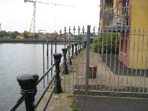
- Currently, the river corridor is being used for residential development and for some commerce and light industry. Small attempts have been made to create recreational spaces along the river, such as walkways, public art and open public spaces. However, these areas are not well connected and therefore are not being used in adequate proportion to the city's population or recreation needs. In addition, much of the residential development is inwardly focused and does not acknowledge public space along the river - many of the new developments are claiming riverfront space and privatising this space, making the river corridor even more disconnected. The photo below illustrates what was once a public walkway, which is now fenced to limit use of the space for residents of this set of flats.
Future development directions
Project goals:
- A person should be able to ride a bicycle or a racing wheelchair around the entire Lagan perimeter.
- A person should be able to walk any part of the river’s edge during daylight hours and feel safe.
- A person should have clear visibility and obvious connection to all the amenities along the river.
- The river should belong to the city of Belfast and be available as a public amenity to all the citizens and tourists.
- The river should provide wildlife habitat and a venue for introducing city dwellers to the natural world
Peer reviews or critique
- The project has been reviewed by my thesis committee, each of whom has a unique perspective to lend to the project. The chairperson is a landscape architect with many years of experience in urban design. The other committee members have specialties in cultural landscapes and planning. The Lagan project is complex, and I have great hopes for at least some of the ideas explored here being implemented. My Professors caution me to stay focused and not allow the cultural situation to distract me from good design work.
- Please, anyone else who wishes to comment on this project, feel free to do so. I am particularly interested in hearing European perspectives because I am American.
Points of success and limitations
- The main indicator of success for the project is that Belfastians begin to use, and appreciate their river more.
- The main limitations are time, and the fact that I am presently in the United States and out of reach physically from the project.
What can be generalized from this case study?
- The greatest insight I have found so far is this: The people of Belfast, for the most part, desire normalcy and an appreciation that they are a cosmopolitan, European city of the new millenium. So, I am going to conduct my design process just as I would for any city, and although certain issues still need to be handled sensitively, I will not dwell on the past problems of Belfast. I hope to give them a vision for a future they can all enjoy together.
Which research questions does it generate?
Short statement plus background notes
Image Gallery
- Yourimage.jpg
your image text
References
Please add literature, documentations and weblinks
About categories: You can add more categories by copying the tag and filling in your additional categories


