Collaborative Design Planting Design Working Group 30: Difference between revisions
No edit summary |
|||
| Line 68: | Line 68: | ||
<gallery caption="Analytical Drawings " widths="150px" heights="150px" perrow="4"> | <gallery caption="Analytical Drawings " widths="150px" heights="150px" perrow="4"> | ||
Image: | Image:BB - park areas.jpg|analytical drawing 1 | ||
Image: | Image:Natalia_vicente_15.jpg|analytical drawing 2 | ||
Image: | Image:yourfilename3.jpg|analytical drawing 3 | ||
Image: | Image:BB - analitical.jpg|analytical drawing 4 | ||
</gallery> | </gallery> | ||
Revision as of 15:15, 26 January 2014
---> back to group page working group 30
President Ronald Reagan's Park
| Name | President Ronald Reagan's Park | |
| Location | Gdańsk | |
| Country | Poland | |
| Authors | Barbara,Azadeh, Natalia | |
| 300px | ||
|
| ||
Landscape and/or urban context of your case
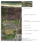
The President Ronald Reagan's Park is a large public space located near the costline of Baltic Sea on the northern side of Gdańsk. It is separated from the beach only by a narrow line of protected dune. It's the biggest park in the City and one of the newest. It was established between year 2003 and 2006. Now the Park encompases 55,5 ha, but it's eastern part is not yet developed in accordence with it's purpose. The whole area is protected not only because it's considered a wetland but also because it's a part of underground drinking water spring for a considerable part of Gdańsk. The Park became a weekend escape, place to meet and go in for sports for city residents of all ages. I selected this site because it is a good example of understanding and cooperation between local government and community also taking into account the needs of nature.
- Illustration: Map; sketches; short descriptive analyses
What are the objectives of your design?
Objectives:
- analising existing vegetation structure
- analising climate, water and siol condition
- chosing vegetation in concideration of climate and soil conditions
- make note of endurance of species
- giving social and educational function to the vegetation
- avoiding or dispose of invasive species
- walkway over sand dunes to protect plants ecosystem
- protecting threatened native plants with chicken wire
- preserving animal habitants
- inviting people in for activities and educational purposes
Analytical drawings
Please add four analytical sketches/drawings (or montages/schemes) of your case. Every group member needs to contribute at least one drawing.
- Analytical Drawings
- Yourfilename3.jpg
analytical drawing 3
Projective drawings
Please add four projective sketches/drawings (or montages/schemes), of course with an emphasis on planting design/vegetation aspects. Every group member needs to contribute at least one drawing representing his/her individual ideas.
- Projective Drawings
- Yourfilename1.jpg
projective drawing 1
- Yourfilename2.jpg
projective drawing 2
- Yourfilename3.jpg
projective drawing 3
- Yourfilename4.jpg
projective drawing 4
Design Synthesis
Please analyse the individual approaches presented so far and evaluate their strengths and weaknesses (you may use the SWOTanalysis model). Try to create a synthesis and represent it with a plan and some sketches. You can still use drawings/sketches.
- Design Synthesis Drawings
- Yourfilename1.jpg
synthesis drawing 1
- Yourfilename2.jpg
synthesis drawing 2
- Yourfilename3.jpg
synthesis drawing 3
- Yourfilename4.jpg
synthesis drawing 4
Summary of the collaborative process
Please reflect on your collaborative design process. Which potentials have you encountered? What was most difficult? What does collaborative design mean for you? (approx 150 words).
Image Gallery
You may add a series of images/photos in addition to the sketches/drawings
- Image Gallery
- Yourfilename1.jpg
image 1
- Yourfilename2.jpg
image 2
- Yourfilename3.jpg
image 3
- Yourfilename4.jpg
image 4
References
* Please make sure that you give proper references of all external resources used.
* Do not use images of which you do not hold the copyright.
* Please add internet links to other resources if necessary.
About categories: You can add more categories with this tag: "", add your categories


