Collaborative Design Planting Design Working Group 24: Difference between revisions
| Line 37: | Line 37: | ||
'''History''' | '''History''' | ||
The territory has been | The territory has been habitated at least since the Eneolithic time (Copper age), there is an old settlement of that time in the slopes of the Machotas mountains, as well as El Dehesón archeological site, related to the megalithic tombs of Dolmen del Rincón and burial state of Canto de Castrejón, among other megalithic tombs and findings on the sourrondings. From the Roman time it was found a ''civitas'' near the Guadarrama river banks, unfar from the today ruins of Monesterio (a Midde Age village and later palace of Philipp II), as well as old roman roads, and a late roman hostels was excabated recently at the neighbour village of Collado Mediano. The old Roman roads where used later during the Visigothic and Arab times, although the Hispanoarabs built new roads crossing the mountains. | ||
During the Arab rule in the early Middle Age there were some scattered Mozarabe small villages. The region was later taken by the knights and settlers from Segovia, taking importance the villages of El Escorial and Navalquejigo, among other smaller places. During the late Middle Age several palaces and towers were built by landlords and kings in the area, as El Campillo, which later were bought, renovated and adapted by Philipp II. Before the Renaissance the economy was based on extensive cattling and family scale agriculture. | During the Arab rule in the early Middle Age there were some scattered Mozarabe small villages. The region was later taken by the knights and settlers from Segovia, taking importance the villages of El Escorial and Navalquejigo, among other smaller places. During the late Middle Age several palaces and towers were built by landlords and kings in the area, as El Campillo, which later were bought, renovated and adapted by Philipp II. Before the Renaissance the economy was based on extensive cattling and family scale agriculture. | ||
| Line 44: | Line 44: | ||
The Monastery and related palaces, mannors and lands inside this historical territory include some of the most relevant renacentist and neoclassical gardens in Spain and the landscape has been an important issue since Philipp II, who was a passionated lover of Nature and gardens, organising mayor planting operations in the mountains in different parts of Spain, and creating gardens and orchards in all his mayor palaces and residencies. | The Monastery and related palaces, mannors and lands inside this historical territory include some of the most relevant renacentist and neoclassical gardens in Spain and the landscape has been an important issue since Philipp II, who was a passionated lover of Nature and gardens, organising mayor planting operations in the mountains in different parts of Spain, and creating gardens and orchards in all his mayor palaces and residencies. | ||
In 1961 a part of it, the Mount Abantos, got the protection figure of Picturesque Landscape. | In 1961 a part of it, the Mount Abantos and La Herrería oak ans sweet chestnuts Forest, got the protection figure of Picturesque Landscape (15.39 sq.Km). | ||
The UNESCO entitled the Royal | The UNESCO entitled the Royal Monastery and Historical Site of El Escorial as World Heritage Site in 1984; nevertheless, part of the territory had not a real protection and underwent several contructions in the following decades, which has been strongly contested by local and regional ecologist organisations. In 1995 la Herrería oaks, maple, ash-trees and sweet chestnuts forest was declared a Forest of Special Ecological Interest. In 2006 the Regional Government of Madrid entitled the Royal Wall and the whole land, forests, archeological settlements, monuments and gardens within, as Cultural Protected Item (BIC) as Historic Territory. The place is also part of the European Nature 2000 habitat of the Guadarrama river and is considered a part of the landscape and environmetal buffer zones for the recently aprobed National Park of the Sierra de Guadarrama Summits. | ||
'''Nature''' [http://www.sanlorenzoturismo.org/ingles/entorno_natural/flora.asp] | '''Nature''' [http://www.sanlorenzoturismo.org/ingles/entorno_natural/flora.asp] | ||
The territory climbs from the 800 to the 1753 m above the sea (Abantos summit) and includes a wide range of biotops, from wet endorreic areas and lacoons in the lowerlands to grasspastures in the upper part of the mountains. | The territory climbs from the 800 to the 1753 m above the sea (Abantos summit) and includes a wide range of biotops, from wet endorreic areas and lacoons ('lavajos' with ''Potamogeton natans'', ''Ranunculus peltatus'' and other water plants) in the lowerlands to srubs (''Citisus oromediterraneus'' aka ''C. purgans'', ''Genista cinaerescens'', grasspastures (''Nardus stricta'', ''Deschampsia flexuosa'') in the upper part of the mountains. | ||
The mountains slopes are characterised by pine forests of several indigenous species ( | The mountains slopes are characterised by pine forests of several indigenous species (from the lower to the higher places: ''Pinus pinea'', ''P. nigra'' sp. ''salzmannii" v. "hispanica'', ''P. pinaster'', ''P. sylvestris'' sp. ''iberica'' [http://www.sanlorenzoturismo.org/ingles/entorno_natural/documentos/pinar_flora.pdf] including several alloctonous exemplars and groves of ''P. muga'', ''P. radiata'', ''P. jeffreyi'', ''P. sabiniana'' and ''P. culterii'') and the related species growing with them, togehter with Juniperus (''J. oxycedrus'', ''J. communis'', ''J. alpina nana''), very old yew trees (''Taxus baccata'') and some other exoticals (''Larix decidua'', ''Cedrus atlantica'', ''Cedrus libani'', ''Picea abies'', ''Pseudotsuga menziesii'', ''Cupressus × leylandii'', all of them planted by the Forestry Engineering School between 1888 and 1914) and decidious trees as ''Sorbus acucuparia'', ''Amelanchier ovalis'',''Ulmus laevis'', ''Ulmus nigra'' and most of the typical of the oaks forest,entering the pine forests from the surrondigss, as well as ''Betula alba'' sp. ''celtiberica'', together with aforested beechtrees (''Fagus sylvatica''), maples (''Acer pseudoplatanus'' and ''A. platanoides'') and oaks (''Quercus robur'') silver fir (''Abies alba'') all from North Spain and pinsapo fir trees (''Abies pinsapo'') from the South. | ||
[http://www.sanlorenzoturismo.org/ingles/entorno_natural/documentos/ | |||
The lower mountains bear mature forests of Pyrenean oak (''Quercus pyrenaica'') [http://www.sanlorenzoturismo.org/ingles/entorno_natural/documentos/herreria_flora.pdf] with a rich biodiversity, including a relictics forest of sweet chesnuts (''Castanea sativa''), as well as ''Acer monspessulanum'', ''Corylus avellana'', ''Malus sylvestris'', ''Pyrus bourgaeana'', ''Prunus avium'', ''Prunus spinosa'', ''Rhamnus cathartica'', ''Quercus faginea'', ''Fraxinus angustifolia''. In the lowe lands ther are open forests and groves of ''Quercus ilex'' sp. ''ballota'' and ''Fraxinus angustifolia'', sharing the land with pastures of the ''Poa pratensis'' and ''Trifolium sunterraneum association'' (priority habitat of the UE Habitat Directive) together with a rich grass and herbs biodiversity. | |||
'''Landscape''' | '''Landscape''' | ||
This area of study is one of the most relevant natural and cultural landscapes in Central Spain. It takes the form of an valley from San Benito summit and the Cruz Verde mountain pass, between mountains chains of Machotas souhtwards and of sierra de Malagón (Risco Alto, Abantos, San Juan, La Naranjera) northeastwards. The valley begins very narrow and opens gradually to the plateaus at the foot of the mountains. | |||
''The Landscape Atlas of Madrid'' [http://www.madrid.org/cs/Satellite?blobcol=urldata&blobheader=application%2Fpdf&blobheadername1=Content-Disposition&blobheadervalue1=filename%3DPaisaje_J23.pdf&blobkey=id&blobtable=MungoBlobs&blobwhere=1220582322103&ssbinary=true] defines four landscape units in the zone: | |||
'''G03 Valle de los Caídos'', of 3356 Ha. Average altitude: 1317 m. Constituted by the physiograhic elements: upper sierra slopes and mountain water courses, gneiss and granite rocks formations. Vegetation: mountain pasture and srubs, pine forests of ''Pinus sylsvestris'', ''P. pinaster'' and other trees. Main water courses: El Boquerón, Las Chorreras. Lakes and reservoirs: El Boquerón. | |||
'''G04 El Campillo''', 2960 Ha. Average altitude 973 m Phyisiographic elements: valley Valle de los Caídos, lower parts of the mountains ad valleys, mountain slopes, climbing plateaus ('rampas'), foothills, , depressions ('navas'). Xerophytic pastures and grasslands , holm oak and ash tree groves and open forests (dehesas). Water courses: El Barrancón, Guadarrama, Loco, Pradovera, El Agua, Loyón, Guatel Primero, Guatel Segundo. Small endorreic lacoons ('lavajos') scatered on the lower parts. | |||
'''G06 El Escorial''' 3713 Ha. Average altitude: 1143 m. Urban structures: El Escorial, San Lorenzo de El | |||
Escorial. Physiographic elements: mountain slopes, step slopes, foothills, climbing plateaus ('rampas'), depressions ('navas'). Vegetation: Xerophytic pastures and grasslands, srubs, Pine foreMatorrales de leguminosas; | |||
Scots pine forests, Pyrenean oak forests. Water courses: La Torrecilla, El Batán, El Valle, Los Castaños, El Helechal, El Romeral, Los Gallegos, Las Cebadillas, La Cruz, El Barrancón. Reservoirs: Embalse El Batán, Embalse El Romeral (16, 18 and 19th. Centuries), Presa El Infante (18th. Century), El Castañar. | |||
'''G07 Embalse de Valmayor''' 6277 Ha. Average altitude: 874 m. Urban setlements of El Arcor, Paraíso, Parque de | |||
las Infantas, Pinosol, Los Arroyos and old village Navaquejigo. Physiogreaphic elements: Mountain foot, foothills, step slopes, depressions ('navas') and endorreic laoons ('lavajos'). Vegetation: Xerophytic pasteres and grasslands, open hom oak foress ('dehesas'), mature holm oak and ash tres forests, holm oak srubs, open Pyrenean forests. Water courses: river Aulencia, La Cañada, El Batán, La Fuente del Tejadillo, El Tercio. Lakes and water reservoirs: embalse Los Arroyos, Embalse Valmayor, La Granjilla I, La Granjilla II, La Granjilla III (these three built 16 th. Century by durch dick engineer jansen under comission of Philipp II as part of the gardens complex La Granjilla). | |||
'''Historical and relevant gardens.''' | |||
Gardens of the Royal Monastery San lorenzo de EL Escorial (began by Marc de Orrils, Marcos de Cardona, gardener of Charles V and Philipp II): King and Queen Gardens. Monk Orchards. Monks garden. 16 th, partly reformed 18th Century. | |||
La Granjilla or Fresneda Gardens (Including reservoirs made by duth dike engineer Jansen) 16th Century. | |||
El Castañar. 16 th Century | |||
Casita del Príncipe Gardens, park and orchards. By architect Juan de Villanueva. 18th Century. | |||
Casita del Infante Gardens. By Juan de Villnanueva. 18th Century. 19th Cnetury enlargement. Restoration by Landscape Architect and Gardens Historian Xavier de Winthuysen in the 1940's. | |||
Parque de Los Alamillos (University Park or Park Carrero). 19 and 20 Centuries. | |||
Arboretum Luis Ceballos. Late 20th Century | |||
Revision as of 18:12, 22 January 2014
---> back to group page working group 24
Landscape at the Historical Site of El Escorial (Spain)
| Name | Landscape of the historical Cerca Real (Royal Wall) Territory at El Escorial | |||||||||||
| Location | El Escorial (Madrid) | |||||||||||
| Country | Spain | |||||||||||
| Authors | Francisco Felipe-Martínez, Le Trang Nguyen, Irina Slobozeanu | |||||||||||

| ||||||||||||
| {{#widget:GoogleMaps | width=300 | height=200 | lat=40.5956 | lng=-4.1658 | zoom=11 | centermarker=yes | maptypecontrol=yes | overviewmapcontrol=yes | largemapcontrol=yes | scalecontrol=yes
}} | ||
Landscape and/or urban context of your case
- Biogeography, cultural features, overall character, history and dynamics
History
The territory has been habitated at least since the Eneolithic time (Copper age), there is an old settlement of that time in the slopes of the Machotas mountains, as well as El Dehesón archeological site, related to the megalithic tombs of Dolmen del Rincón and burial state of Canto de Castrejón, among other megalithic tombs and findings on the sourrondings. From the Roman time it was found a civitas near the Guadarrama river banks, unfar from the today ruins of Monesterio (a Midde Age village and later palace of Philipp II), as well as old roman roads, and a late roman hostels was excabated recently at the neighbour village of Collado Mediano. The old Roman roads where used later during the Visigothic and Arab times, although the Hispanoarabs built new roads crossing the mountains.
During the Arab rule in the early Middle Age there were some scattered Mozarabe small villages. The region was later taken by the knights and settlers from Segovia, taking importance the villages of El Escorial and Navalquejigo, among other smaller places. During the late Middle Age several palaces and towers were built by landlords and kings in the area, as El Campillo, which later were bought, renovated and adapted by Philipp II. Before the Renaissance the economy was based on extensive cattling and family scale agriculture.
In the XVIth. Century, when the Royal Monastery of St. Lawrence at El Escorial was built by Philipp II (the contruction of the 4 Ha building took from 1563 to 1584) the same king decided to enclose the whole Monastery lands and related territories, as well as several already existing or new constructed palaces and mannors, by a 55 km long granite and gneis stone wall(Gran Cerca or Pared Real). It was renovated in 1793. The Monastery and related palaces, mannors and lands inside this historical territory include some of the most relevant renacentist and neoclassical gardens in Spain and the landscape has been an important issue since Philipp II, who was a passionated lover of Nature and gardens, organising mayor planting operations in the mountains in different parts of Spain, and creating gardens and orchards in all his mayor palaces and residencies.
In 1961 a part of it, the Mount Abantos and La Herrería oak ans sweet chestnuts Forest, got the protection figure of Picturesque Landscape (15.39 sq.Km). The UNESCO entitled the Royal Monastery and Historical Site of El Escorial as World Heritage Site in 1984; nevertheless, part of the territory had not a real protection and underwent several contructions in the following decades, which has been strongly contested by local and regional ecologist organisations. In 1995 la Herrería oaks, maple, ash-trees and sweet chestnuts forest was declared a Forest of Special Ecological Interest. In 2006 the Regional Government of Madrid entitled the Royal Wall and the whole land, forests, archeological settlements, monuments and gardens within, as Cultural Protected Item (BIC) as Historic Territory. The place is also part of the European Nature 2000 habitat of the Guadarrama river and is considered a part of the landscape and environmetal buffer zones for the recently aprobed National Park of the Sierra de Guadarrama Summits.
Nature [1]
The territory climbs from the 800 to the 1753 m above the sea (Abantos summit) and includes a wide range of biotops, from wet endorreic areas and lacoons ('lavajos' with Potamogeton natans, Ranunculus peltatus and other water plants) in the lowerlands to srubs (Citisus oromediterraneus aka C. purgans, Genista cinaerescens, grasspastures (Nardus stricta, Deschampsia flexuosa) in the upper part of the mountains. The mountains slopes are characterised by pine forests of several indigenous species (from the lower to the higher places: Pinus pinea, P. nigra sp. salzmannii" v. "hispanica, P. pinaster, P. sylvestris sp. iberica [2] including several alloctonous exemplars and groves of P. muga, P. radiata, P. jeffreyi, P. sabiniana and P. culterii) and the related species growing with them, togehter with Juniperus (J. oxycedrus, J. communis, J. alpina nana), very old yew trees (Taxus baccata) and some other exoticals (Larix decidua, Cedrus atlantica, Cedrus libani, Picea abies, Pseudotsuga menziesii, Cupressus × leylandii, all of them planted by the Forestry Engineering School between 1888 and 1914) and decidious trees as Sorbus acucuparia, Amelanchier ovalis,Ulmus laevis, Ulmus nigra and most of the typical of the oaks forest,entering the pine forests from the surrondigss, as well as Betula alba sp. celtiberica, together with aforested beechtrees (Fagus sylvatica), maples (Acer pseudoplatanus and A. platanoides) and oaks (Quercus robur) silver fir (Abies alba) all from North Spain and pinsapo fir trees (Abies pinsapo) from the South.
The lower mountains bear mature forests of Pyrenean oak (Quercus pyrenaica) [3] with a rich biodiversity, including a relictics forest of sweet chesnuts (Castanea sativa), as well as Acer monspessulanum, Corylus avellana, Malus sylvestris, Pyrus bourgaeana, Prunus avium, Prunus spinosa, Rhamnus cathartica, Quercus faginea, Fraxinus angustifolia. In the lowe lands ther are open forests and groves of Quercus ilex sp. ballota and Fraxinus angustifolia, sharing the land with pastures of the Poa pratensis and Trifolium sunterraneum association (priority habitat of the UE Habitat Directive) together with a rich grass and herbs biodiversity.
Landscape
This area of study is one of the most relevant natural and cultural landscapes in Central Spain. It takes the form of an valley from San Benito summit and the Cruz Verde mountain pass, between mountains chains of Machotas souhtwards and of sierra de Malagón (Risco Alto, Abantos, San Juan, La Naranjera) northeastwards. The valley begins very narrow and opens gradually to the plateaus at the foot of the mountains.
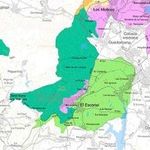
The Landscape Atlas of Madrid [4] defines four landscape units in the zone:
'G03 Valle de los Caídos, of 3356 Ha. Average altitude: 1317 m. Constituted by the physiograhic elements: upper sierra slopes and mountain water courses, gneiss and granite rocks formations. Vegetation: mountain pasture and srubs, pine forests of Pinus sylsvestris, P. pinaster and other trees. Main water courses: El Boquerón, Las Chorreras. Lakes and reservoirs: El Boquerón.
G04 El Campillo, 2960 Ha. Average altitude 973 m Phyisiographic elements: valley Valle de los Caídos, lower parts of the mountains ad valleys, mountain slopes, climbing plateaus ('rampas'), foothills, , depressions ('navas'). Xerophytic pastures and grasslands , holm oak and ash tree groves and open forests (dehesas). Water courses: El Barrancón, Guadarrama, Loco, Pradovera, El Agua, Loyón, Guatel Primero, Guatel Segundo. Small endorreic lacoons ('lavajos') scatered on the lower parts.
G06 El Escorial 3713 Ha. Average altitude: 1143 m. Urban structures: El Escorial, San Lorenzo de El Escorial. Physiographic elements: mountain slopes, step slopes, foothills, climbing plateaus ('rampas'), depressions ('navas'). Vegetation: Xerophytic pastures and grasslands, srubs, Pine foreMatorrales de leguminosas; Scots pine forests, Pyrenean oak forests. Water courses: La Torrecilla, El Batán, El Valle, Los Castaños, El Helechal, El Romeral, Los Gallegos, Las Cebadillas, La Cruz, El Barrancón. Reservoirs: Embalse El Batán, Embalse El Romeral (16, 18 and 19th. Centuries), Presa El Infante (18th. Century), El Castañar.
G07 Embalse de Valmayor 6277 Ha. Average altitude: 874 m. Urban setlements of El Arcor, Paraíso, Parque de las Infantas, Pinosol, Los Arroyos and old village Navaquejigo. Physiogreaphic elements: Mountain foot, foothills, step slopes, depressions ('navas') and endorreic laoons ('lavajos'). Vegetation: Xerophytic pasteres and grasslands, open hom oak foress ('dehesas'), mature holm oak and ash tres forests, holm oak srubs, open Pyrenean forests. Water courses: river Aulencia, La Cañada, El Batán, La Fuente del Tejadillo, El Tercio. Lakes and water reservoirs: embalse Los Arroyos, Embalse Valmayor, La Granjilla I, La Granjilla II, La Granjilla III (these three built 16 th. Century by durch dick engineer jansen under comission of Philipp II as part of the gardens complex La Granjilla).
Historical and relevant gardens.
Gardens of the Royal Monastery San lorenzo de EL Escorial (began by Marc de Orrils, Marcos de Cardona, gardener of Charles V and Philipp II): King and Queen Gardens. Monk Orchards. Monks garden. 16 th, partly reformed 18th Century.
La Granjilla or Fresneda Gardens (Including reservoirs made by duth dike engineer Jansen) 16th Century.
El Castañar. 16 th Century
Casita del Príncipe Gardens, park and orchards. By architect Juan de Villanueva. 18th Century.
Casita del Infante Gardens. By Juan de Villnanueva. 18th Century. 19th Cnetury enlargement. Restoration by Landscape Architect and Gardens Historian Xavier de Winthuysen in the 1940's.
Parque de Los Alamillos (University Park or Park Carrero). 19 and 20 Centuries.
Arboretum Luis Ceballos. Late 20th Century
- Maps
-
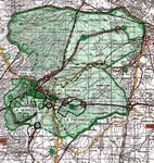 Historical Territory of the Royal Wall
 -
 Protected Landscape & Historic Territory


What are the objectives of your design?
Please give a short written argumentation (not more than 150 words). It is ok if you have different or even contradicting objectives within your group. Just make it explicit at the beginning of your process
Analytical drawings
Please add four analytical sketches/drawings (or montages/schemes) of your case. Every group member needs to contribute at least one drawing.
- Analytical Drawings
-
analytical drawing 1
-
analytical drawing 2
-
analytical drawing 3
-
analytical drawing 4
Projective drawings
Please add four projective sketches/drawings (or montages/schemes), of course with an emphasis on planting design/vegetation aspects. Every group member needs to contribute at least one drawing representing his/her individual ideas.
- Projective Drawings
-
projective drawing 1
-
projective drawing 2
-
projective drawing 3
-
projective drawing 4
Design Synthesis
Please analyse the individual approaches presented so far and evaluate their strengths and weaknesses (you may use the SWOTanalysis model). Try to create a synthesis and represent it with a plan and some sketches. You can still use drawings/sketches.
- Design Synthesis Drawings
-
synthesis drawing 1
-
synthesis drawing 2
-
synthesis drawing 3
-
synthesis drawing 4
Summary of the collaborative process
Please reflect on your collaborative design process. Which potentials have you encountered? What was most difficult? What does collaborative design mean for you? (approx 150 words).
Image Gallery
You may add a series of images/photos in addition to the sketches/drawings
- Image Gallery
-
image 1
-
image 2
-
image 3
-
image 4
References
* Please make sure that you give proper references of all external resources used.
* Do not use images of which you do not hold the copyright.
* Please add internet links to other resources if necessary.
External links
Nature[5] Historical Heritage[6] Royal Monastery of El Escorial[7] Monastery[8] Casita del Príncipe Palace, Gardens and Orchards[9] Casita del Príncipe[10] Casita del Príncipe Palace, Gardens, Orchards and Parc (extensive, in Spanish)[11] Casita del Infante Palace[12] Casita del Infante Gardens[13] Arboreto Luis Ceballos[14]
About categories: You can add more categories with this tag: "", add your categories