Group B - Collaborative Climate Adaption Project: Difference between revisions
No edit summary |
No edit summary |
||
| Line 432: | Line 432: | ||
== What can be generalized from this case study? == | == What can be generalized from this case study? == | ||
* | * The Flood in this study area is caused not only by climate change but also by haphazard urban growth. | ||
* Research questions: How to develop effective community oriented flood control measures for low income areas? | * Research questions: How to develop effective community oriented flood control measures for low income areas? | ||
Revision as of 12:52, 3 February 2013
- Back to working group overview
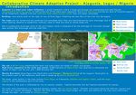
| Area | Ajegunle | |||||||||||
| Place | Lagos state | |||||||||||
| Country | Nigeria | |||||||||||
| Topic | Climate Change Impacts on Coastal Settlements | |||||||||||
| Author(s) | Kinga Jánossy, Melissa Abas and Fadera Williams | |||||||||||

| ||||||||||||
| {{#widget:GoogleMaps | width=300 | height=200 | lat=6.605 | lng=3.438 | zoom=10 | centermarker=no | maptypecontrol=yes | overviewmapcontrol=yes | largemapcontrol=yes | scalecontrol=yes
}} | ||
Rationale: Why have you selected this case study area?
- In African country like Nigeria, climate change has very big impacts to its sustainable development. Lagos, a state in the south part of Nigeria, is one example of area that is vulnerable to the influence of climate change. Therefore, widespread ecosystem degradation may occur, thus disrupting social-economic system, unless concerted and urgent action is taken.
- In Lagos state, poor people living on coastal area have high probability from flooding on heavy rainfall season. Settlement located in this risky area cope with influences such as property damage, temporary homelessness, and spread of illness due to unhygienic sanitation. Additionally, worst damage may occur due to the rising of sea levels and climate change.
- The study area is set in Ajegunle, it is located in Kosofe (local government area of Lagos state, Nigeria). The site is a major poor urban settlement. This is largely due to their low level of financial capacity coupled with low education and inefficient land administration system which have further exclude them from urban life and increased their vulnerability to eviction, flood, natural disaster and environmental health problem. Therefore, any attempt to achieve livable, healthy and prosper city must as a matter of urgency address housing issue. This means that there must be a conscious effort focusing on provision of settlement planning for the poor at an affordable rate.
Authors' perspectives
Climate change affects not only environmental problem, but also social, health, economic, and viability matter. Although Africa contribute only 3% GHG emission for the global warming (Ogunlade, 2008), it is more vulnerable due to the lack of infrastructure, technology, social and economy to manage its effect of global warming and climate change such as storm, flood, drought, land slide, etc. Within landscape architecture knowledge, approach to improve sustainable urban planning for adapting the challenge is necessary.
Cultural/social/political context

- Lagos is a city and chief port in Lagos state, Nigeria. Until 1975 it was the capital of Lagos state, and until December 1991 it was the federal capital of Nigeria. Ikeja replaced Lagos as the state capital, and Abuja replaced Lagos as the federal capital. Lagos, however, remained the unofficial seat of many government agencies. The city’s population is centered on Lagos Island, in Lagos Lagoon, on the Bight of Benin in the Gulf of Guinea. Lagos is Nigeria’s largest city, which projected to be one of the world's five largest cities and one of the largest in sub-Saharan Africa.
- The Portuguese first landed on Lagos Island in 1472, while the area were settled by Yoruba fishermen and hunters, who called it Oko. Later on, from the late 16th century to the mid 19th century, the island was dominated by the kingdom of Benin, which called it Eko. The local obas (kings) enjoyed good relations with the Portuguese, who called the island Onim (and later Lagos) and who established a flourishing slave trade. British attempts to suppress the slave trade culminated in 1851 in a naval attack on Lagos and the deposition of the oba. The slave trade continued to grow, however, until Lagos came under British control in 1861.
- Originally governed as a British crown colony, Lagos was part of the United Kingdom’s West African Settlements from 1866 to 1874, when it became part of the Gold Coast Colony (modern Ghana). In 1886 it again achieved separate status under a British governor, and in 1906 it was amalgamated with the Protectorate of Southern Nigeria. When Southern and Northern Nigeria were amalgamated in 1914, Lagos was made the capital of the Colony and Protectorate of Nigeria. In 1954 most of the hinterland was incorporated into the region of Western Nigeria, while the city itself was designated as federal territory. In 1960 Lagos became the capital of independent Nigeria. Control of its hinterland was returned to the city in 1967 with the creation of Lagos state. After 1975 a new national capital, centrally situated near Abuja, was developed to replace Lagos, which by then suffered from slums, environmental pollution, and traffic congestion.
- Ajegunle falls under the Badagry Division and consists of people from all parts of the country with the dominant groups being the Ijaw, Ilaje, Hausa, Ibo, Urhobo and Yoruba ethnicity. The others are: Badagry, Ajara, Iworo-Ajido, Akarakumo, Gbaji, Aseri, Egan, Agarin, Ahanfe, Epe, Posi, Mowo, Itoga, Ebiri, Ekunpa, Aradagun, Berekete, Mosafejo, Gayingbo-Topo, Kankon, Moba, Popoji, Oranyan, Tafi-Awori, Yeketome, Ipota, Seme, Iyagbe, Ajegunle, Aiyetoro, Festac and Satellite Towns, Iba, Kirikiri, Agboju-Amuwo, Okokomaiko, Ojo, Amukoko, Alaba-ore, Ijofin, Igbanko, Imore, Ijegun, Odan Group of villages and part of Agara.
- According to Stoveland Consult, WTP Study of 1997 majority of the multi-ethnic population of Ajegunle are of school age and highly, economically productive. Their main occupation is trading in the formal and informal sectors.
- The Lagos metropolitan area is also a major educational and cultural centre. The University of Lagos (1962), the National Library, the Lagos City Libraries, and the National Museum (1957), with excellent historical examples of Nigerian arts and crafts, are all located in the city or its suburbs. The city is also the headquarters of the Federal Radio Corporation of Nigeria and the Nigerian Television Authority. The airport at Ikeja provides local and international services.
Urban context

- Lagos is the most populous city in Nigeria, the largest country in Africa. The metropolitan area, an estimated 300 square kilometers, is a group of islands endowed with creeks and a lagoon. In an effort to reduce massive urbanization in the metropolitan area, the Federal Government moved the capital to Abuja. Ajegunle has a population density of 7,941/km2.
- Energy and water access, sewerage, transportation and housing have all been adversely affected by haphazard development of a geographically disjointed city. Unlike the rest of Nigeria, 90% of the population of Lagos have access to electricity, with the city consuming 45% of the energy of the country. Despite the region's endowment of water, the city suffers from an acute and worsening water supply shortage. And due to inadequate sewerage, much the city's human waste is disposed of by the drainage of rainwater through open ditches that discharge onto the tidal flats.
- In Ajegunle, over 70% of the buildings in the area are Brazilian type while 13.1% of the buildings in Ajegunle are traditional compound type and 9.2% are flat. It is not surprising that most of the building are Brazilian buildings or apartment because it is believed to be the main design and characteristics of low income group as well as poor communities in Nigeria cities. Most of the buildings (50.3%) are predominantly residential however, a significant proportion representing 40.5% of the buildings are mixed use while other land uses account for 9.2%.
- About 85.9% of the buildings are accessible by roads but, the main problem is that majority of the roads are not tarred and the conditions are extremely poor. The roads are characterized by poor drainage, lack of street lighting, absence of pedestrian walkway as well as on street parking. Also some of the roads are used as refuse dump site.
- The Dustbin Estate is a collection of shanties on refuse dump where a very poor set of people live in Ajegunle. Living on a large heap of rubbish poses a myriad of health hazards to both adults and the children, not neglecting the attendant environmental issues. Whenever there is rainfall, the situation is worsened as the entire ‘estate’ is soaked in flood and people still go about their normal duties in this deplorable state. One wonders how these people survive; they eat, drink, have their bath, sleep, talk and do virtually everything in this ever-smelly settlement. Some of them make money from charging people who dispose their refuse here, but one wonders if the income collected for each pack of refuse could ever sum up to justify and alleviate the prevalent abject poverty and hazardous living.
- Geographical Information System shown an extreme rapid loss of biodiversity and environmental degradation in Lagos. This massive degradation resulted into a mosaic of shanties areas in many areas of the city. Poor urban infrastructures such as roads, electricity, health centers, police station drainage systems, and waste management worst the impact.
- In order to upgrade the environment of slum communities, state urban renewal plans built roads and drainage channels, and provided water supply, electricity, schools, and health clinics, beginning in 1985. This efforts, described in UN Publications, are focusing on the crucial infrastructure, result many success in a number of pilot urban renewal plans.
Landscape context

Topography
The topography of the area is generally low-lying undulating flat landform but with some very rugged areas having scalp slopes and gorges. The altitude varies from sea level to about 15 metres above sea level in some parts of Ogodu, Shaginshan and Magodo.
Soil
The area is covered with clay-sandy soil along the coastal axis in the south and clay- loamy soil at the interior part. Apart from the area still covered by forest, most of the clay- loamy soil of the interior have been seriously leached and presently look more like laterite soil. The soil are well drained with the exception of those found in the wetland areas.
Vegetation
The two major vegetation zones that can be identified on the watershed are the high forest vegetation in the north and central part and the swamp/ mangrove forests that covers the southern coastal and flood plains, next to the lagoon. The vegetation of the region is that of coastal swamp and marsh forest, part of which had given way to the construction of houses, markets and other infrastructures.
Hydrology
The major water bodies in the area includes River Ogun and the Lagos Lagoon in the southeastern part of the area. Other important water bodies, which traversed the area, includes the Majidun and Agboyi Rivers.
Climate Conditions


- The climate of the are is influenced by Tropical maritime air mass from the Atlantic ocean, which is warm and wet, and tropical continental air mass from the Sahara desert, which is warm, dry, and clusty. Therefore, the climate is similar to the other coastal region of the tropical West Africa with tropical sub-equatorial climate. The average temperatur is always high whole year, with the maximum is 33.27°C, the mean is 26.77°C, and the minimum is 20.27°C.
- There are two seasons of the are, the wet season and the dry season. The wet season starts from April and ends on October, with August being the little dry season period. The dry season runs from November to March. The maxima of wet season is between June and September, with the average annual rainfall of about 1830mm and the mean daily relative humidity of about 81.65%. However, various anomaly contribute to the rainfall especially between February and May.
- Ajegunle community has existed for 200 years and had been experiencing water level rise over the years. Ogun-Osun river basin development authority manages the Oyan dam. The dam is used for water suply to Lagos and Abeokuta. When heavy rainfall occurs, the dam operators release large volume of water from the dam for safety reasons, results in the flooding of neighbouring communities.
- Very heavy rainfall in May 2009 forced the dam operators to release huge amouts of water for safety reason, causing flooding over an area of 2800 hectares, including Ikorudu, Agiliti, Ajegunle area of Ikorodu, Ojodu Berger, Odogun, Mandun, all in Lagos and Isheri, Maidan, Demo and Isheri in Ogun State. In 2007 water surge in the area destroyed a bridge which is the only link between Ikorodu and metropolitan Lagos.
- The Residents of the Ikorodu axis, comprising six local government areas, suffered untold hardships for months, experienced hectic traffic during the day and night while life generally became a disaster to most residents until the state government rebuilt the bridge. The flow of the ravaging water at Ajegunle, Itowolo and Majidun areas of lkorodu affected buildings because they were built on the right of way of River Ogun. hindering the free flow of the river into the lagoon. Whenever the river overflows it's banks water finds its way into the adjoining communities, causing flooding and destroying facilities like roads, infrastructures, buildings, disrupting business activities. In many areas, the effect was overwhelming. At Unity Street, a popular place in Ajegunle, the entire street was submerged by water, as well as Ifelodun street. In many other places, residents resorted to boarding canoes to get to their houses.
- In June 2012 unpredictable severe rain storms affected Ajegunle community and caused heavy flooding. It has demolished many buildings and properties worth millions naira.
- The climate change also affects the weather condition by prolonging duration of the little dry season on August. The normal duration of the break is six weeks, which is now prolonged much longer.
- Recently, as predicted by the Nigerian Meteorological Agency, the intensity of rainfall is also affected by a series of heatwave that runs from sunny afternoons through the night, which makes the impact felt during the night and influences the rainfall.
Analysis of vulnerability


- Ocean, sea, island and coastal area form an integrated whole that is an essential component of the earth’s ecosystem. It is critical to global food security, sustaining economic prosperity and well-being of many National economies. Much of Nigeria’s population and economic activities are located along the coast and Lagos is one of 8 states which are located in coastal zone.
- Lagos is also the economic and commercial nerve center of Nigeria with over 60% of all industrial and commercial activities and over 40% of Nigeria’s GDP. Incidentally, over 80% of the population and economic activities in Lagos is concentrated within the metropolitan Lagos – a group of barrier islands less than 1000km2 surrounded by creeks and lagoons, bordered by the Atlantic Ocean (Mehrotra, et al. 2009). This over-concentration of people, economic and social assets in a relatively small barrier island highly susceptible to climate change is in itself a recipe for disaster.
- The topography of Lagos is dominated by its system of islands, sandbars, and lagoons. The city itself sprawls over four main islands: Lagos, Iddo, Ikoyi, and Victoria, which are connected to each other and to the mainland by a system of bridges. All the territory is low-lying, the highest point on Lagos Island being only seven meters above sea level and the average height in Lagos is five meters above sea level.
- The Lagos Metropolitan Area is located within the mangrove-rainforest belt of coastal Nigeria. The landform rises slowly through extensive poorly drained marsh and mangrove strata to a height of about 100 metres at a distance of some 50 kilometers inland from the coast. About 50% of this land area has an elevation of less than 15 metres.
- The uplands are divided and given form by two major river systems. The most important of these is the combined Ogun-Owinn River system and their principal tributaries which have created a broad valley, most of which has an elevation of about three to five meters above sea level. This valley separates the eastern highlands to the north of Ikorodu from those laying north and north west of Lagos. The valley is poorly drained and does not provide a hospitable locale for many urban activities. To the west, a similar river system composed of Owa, Ore, lju, Illo and Oruku rivers and their tributaries have etched many long finger-like valleys into the uplands which lie largely in Ogun State.
- The excessive and unpredictable rainfall pattern is due to rise in atmospheric temperature which is a result of ill-human activities accumulated over the years lead the coastal location of Lagos State prone to flooding.
- Despite the environmental challenge posed by flooding due to storm surges and heavy rainstorms exacerbated by urban development, the vulnerability of the growing rapidly urban poor has not been taken into consideration in urban planning and development.
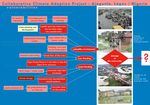
Proposals for Climate Change Adaptation
Tackling the problem of flooding in Ajegunle must be approached from the angle of what causes its regular seasonal flooding. Ajegunle is built on the right of way of the River Ogun, hindering the free flow of the river into the Lagos lagoon. Whenever the river overflows its banks, then the water movers into the neighbouring community causing flooding and destroying several important facilities. In recent years with the advent of climate change, rainfall recorded has been higher and hence its consequences graver. Adapting to the incidence of flooding in the case study area must require a concerted effort to do the following:

Regulation
- Land use zoning should be implemented and enforced.
- Policies which would restrict urban sprawl close to flood planes should be done.
- Watershed management principles should be adopted and setbacks from oceans, lagoons, creeks and rivers enforced.
Sustainable urban drainage systems (SUDs)
Urban forests must be protected as well as the riparian vegetations along water corridors. In lagos metropolis, storm water management is currently limited to 3 channels systems which are the covered concrete drain, uncovered concrete drain and the earth channels. The case study area has an evident abscence of and degradation of drainage channels in several areas which results in stagnant water. Therefore any form of overflow of rainfall will lead to flooding. Sustainable urban drainage systems (SUDs) is another approach at adapting to climate change impacted flooding in the case study area. The philosophy behind this SUDs is to mimic the natural processes by controlling flooding at source.
- Control of rainwater at source through rain water harvesting techniques.
- Introduction of Retention ponds and wetlands.
- Creation of swales and basins.
- Use of infiltration trenches and filter drains.
Build Engineering solutions

- Construction of flood retaining wall and embankment.
- Reducing vulnerabilities of essential infrastructure and communities.
Proposals for Climate Change Mitigation

Education
Ajegunle is a mixed community where a large percentage are unemployed and semi-literate. It is therefore important to consider enlightenment campaigns to educate the local residents on the importance of clearing the drains and the effects of dumping their waste into the drainage channels and storm water management networks.
- Creating awareness, enhancing environmental education and a DIY-Do it yourself approach to flood control.
- Public enlightenment campaign to educate local residents on the importance of clearing drains and the adverse effects of dumping their wastes in drainage channels.
Promoting green infrastructure
This term means propaganda for saving the environment by protecting green infrastructure, urban forest made up of patches, wetland on flood plains, riparian vegetation along water corridors and coastal biodiversity, with focusing on monitoring physical developments. The effort impacts river basin management including ecological water management and ground water. One way is to let people know the importance of reducing their carbon production and input into the environment, for example plant trees and restoring wetlands. Therefore, the lost of green areas that causes global warming can be reduced.
Transmigration
Due to persistent flood that had ravaged in Lagos state, millions of people living in slum area are expected to be relocated to rural area by the government. Apart from the overflowing of the Oyan River the government failed to produce enough channel, canals and gutters that allow easy passage of the flood water, because the available drainage system provided are blocked by the waste tipped into them.
Waste management
In some area, people are still dumping refuse into water bodies and drainage channels. The other wastes are the production of carbon dioxide, sulfur dioxide, nitrogen oxide and other hazardous gases to the environment. When they are burned, they make some parts of gases in atmosphere warmer, which are supposed to be permanently cold. So residents destroy the city with the waste they generate at home and where they dump them. If the waste can be controlled and ensured that it is dumped properly, then we can reduce the environmental damage significantly.
Disaster warning and evacuation method
People can be trained to handle unexpected natural disaster and to use some infrastructure to predict the existence (i.e. weather prediction system). Such planning introduces the community toward actions protecting their lives, properties, empowerment that minimizes the risk of loss and improves quality of life. Appropriate forecast measures and systems should be put in place.
Your scenario

Population and poor urban grow rapidly
- Current demographic trend analysis revealed that the State population growth rate of 8% has resulted in its capturing of 36.8% of Nigeria urban population (World Bank, 1996) estimate at 49.8 million people of the national million population. The implication is that whereas country population growth is 4/5% and global 2%, Lagos population is growing ten times faster than New York and Los Angeles with grave implication for urban sustainability.
- In Kosofe now the male population is 527,539, female population is 407,075, and the total is 934,614. The rate of population growth is about 600,000 per annum with a population density of about 4,193 persons per sq. km. In the built-up areas of Metropolitan Lagos, the average density is over 20,000 persons per square km. Lagos state has a population of about 15,5 million in 2010. Population of Lagos state in year 2060 will be 1,364 million people.
- Increasing population density coupled with increasing frequency and duration of storms surges, possible sea level rise, and other coastal hazards thus result in the impacts of disasters to be more severe and recovery to be slower and less sustainable due to limited basic services and lack of disaster warning and response mechanisms. The complex dynamics between population, environment and the real and perceived vulnerability of large population agglomeration sandwiched by hundreds of small communities and villages on coastal barrier island has always been an object of concern. The infrastructure will not be sufficient enough due to overpopulation in the city.
- The suggestion for year 2060 is to build neatly arranged residential flats, human source development, campaign of birth control and transmigration to rural area, which provides more employment, better income and life quality than in the city.

Sea level rise

In the 20th century, sea levels rose by an estimated 17 centimeters, and the conservative global mean projections for sea-level rise between 1990 and 2080 range from 22 centimeters to 34 centimeters. Oceans, which have been absorbing 80% of the temperature increase attributable to global warming, are expanding as ice sheets in the North and South poles melt. These events have led to a rise in sea levels and increased flooding in coastal cities. The projected rise in sea levels could result in catastrophic flooding of coastal cities. The Lagos state is also situated along coastlines.
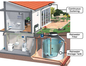
Water Harvesting
To prevent the flood and suffering from drinking water we can use water harvesting, which is the activity of direct collection of rainwater. The rainwater collected can be stored for direct use or can be recharged into the groundwater. Rain is the first form of water that we know in the hydrological cycle, hence is a primary source of water for us. Rivers, lakes and groundwater are all secondary sources of water. In present times, we depend entirely on such secondary sources of water. In the process, it is forgotten that rain is the ultimate source that feeds all these secondary sources and remain ignorant of its value. It taking measures to keep that water clean by not allowing polluting activities to take place in the catchment. Therefore, water harvesting can be undertaken through a variety of ways :
- Capturing runoff from rooftops
- Capturing runoff from local catchments
- Capturing seasonal flood water from local streams
- Conserving water through watershed management
These techniques can serve the following the following purposes:
- Provide drinking water
- Provide irrigation water
- Increase groundwater recharge
- Reduce storm water discharges, urban floods and overloading of sewage treatment plants
- Reduce seawater ingress in coastal areas.

-
 Rain water reservoir
 -
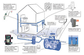 Rain water catchment


Flood canal
Build more flood canal to drain and purge blocked waterways and reconstruct with banks to alleviate flood in rainy season. And also to provide irrigation to local farm plots.

Waste trading
Manage waste to organic and non-organic. Compost organic waste for selling to Farmer as manure or to Biogas facility.

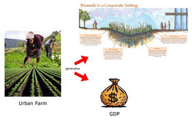
Agricultural production
In parallel to avoiding flood, making more water absorption, provide more water ground, tackle hunger and nourish people, agriculture will also increase GDP of the nation. With agricultural production policy we can treat uncultivated land with seeds, fertilizer and start to produce in order to fulfill the needs of food and might export to another country furthermore.
-
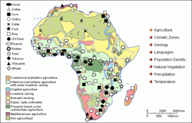 Agricultural resources
 -
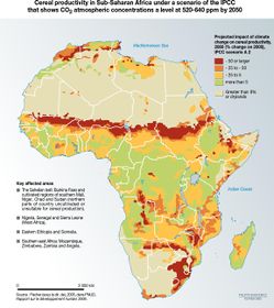 Climate change impact
 -
 Urban farm system


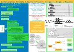
What can be generalized from this case study?
- The Flood in this study area is caused not only by climate change but also by haphazard urban growth.
- Research questions: How to develop effective community oriented flood control measures for low income areas?
- The climate change adaptation and mitigation are our major consideration, but to support its enforcement, the demography and the urban planning need to be controlled. The role of policy and education will avoid more disaster and damage by flood in the future.
Presentation Slides
-
 Slide One
 -
 Slide Two
 -
 Slide Three


Image Gallery
-
 October 2010
 -
 Flood area
 -
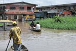 Canoeing in flood
 -
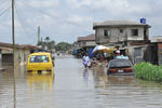
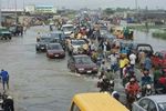 Traffic situation
 -
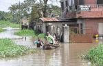
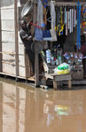 Flood affected settlement
 -
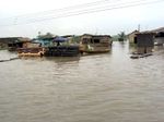
 Flood in urban communities
 -
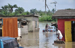 Flood inundated residential
 -
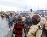 Traffic jam


References
Please add literature, documentations and weblinks
http://www.britannica.com/EBchecked/topic/327849/Lagos
http://234next.com/csp/cms/sites/Next/Home/5728697-146/ajegunle_leaders_meet_to_tackle_climate.csp
http://www.issafrica.org/futures/frame.php?id=137
About categories: You can add more categories with this tag: "", add your categories
{{#widget:WidgetName|param1=value1|param2=value2}}