Group B - Collaborative Climate Adaption Project: Difference between revisions
No edit summary |
No edit summary |
||
| Line 106: | Line 106: | ||
* The Portuguese first landed on Lagos Island in 1472, while the area were settled by Yoruba fishermen and hunters, who called it Oko. Later on, from the late 16th century to the mid 19th century, the island was dominated by the kingdom of Benin, which called it Eko. The local obas (kings) enjoyed good relations with the Portuguese, who called the island Onim (and, later, Lagos) and who established a flourishing slave trade. British attempts to suppress the slave trade culminated in 1851 in a naval attack on Lagos and the deposition of the oba. The slave trade continued to grow, however, until Lagos came under British control in 1861. | * The Portuguese first landed on Lagos Island in 1472, while the area were settled by Yoruba fishermen and hunters, who called it Oko. Later on, from the late 16th century to the mid 19th century, the island was dominated by the kingdom of Benin, which called it Eko. The local obas (kings) enjoyed good relations with the Portuguese, who called the island Onim (and, later, Lagos) and who established a flourishing slave trade. British attempts to suppress the slave trade culminated in 1851 in a naval attack on Lagos and the deposition of the oba. The slave trade continued to grow, however, until Lagos came under British control in 1861. | ||
* Originally governed as a British crown colony, Lagos was part of the United Kingdom’s West African Settlements from 1866 to 1874, when it became part of the Gold Coast Colony (modern Ghana). In 1886 it again achieved separate status under a British governor, and in 1906 it was amalgamated with the Protectorate of Southern Nigeria. When Southern and Northern Nigeria were amalgamated in 1914, Lagos was made the capital of the Colony and Protectorate of Nigeria. In 1954 most of the hinterland was incorporated into the region of Western Nigeria, while the city itself was designated as federal territory. In 1960 Lagos became the capital of independent Nigeria. Control of its hinterland was returned to the city in 1967 with the creation of Lagos state. After 1975 a new national capital, centrally situated near Abuja, was developed to replace Lagos, which by then suffered from slums, environmental pollution, and traffic congestion. | * Originally governed as a British crown colony, Lagos was part of the United Kingdom’s West African Settlements from 1866 to 1874, when it became part of the Gold Coast Colony (modern Ghana). In 1886 it again achieved separate status under a British governor, and in 1906 it was amalgamated with the Protectorate of Southern Nigeria. When Southern and Northern Nigeria were amalgamated in 1914, Lagos was made the capital of the Colony and Protectorate of Nigeria. In 1954 most of the hinterland was incorporated into the region of Western Nigeria, while the city itself was designated as federal territory. In 1960 Lagos became the capital of independent Nigeria. Control of its hinterland was returned to the city in 1967 with the creation of Lagos state. After 1975 a new national capital, centrally situated near Abuja, was developed to replace Lagos, which by then suffered from slums, environmental pollution, and traffic congestion. | ||
* Ajegunle falls under the Badagry Division and consists of people from all parts of the country with the dominant groups being the Ijaw, Ilaje, Hausa, Ibo, Urhobo and Yoruba ethnicity. The others are: Badagry, Ajara, Iworo-Ajido, Akarakumo, Gbaji, Aseri, Egan, Agarin, Ahanfe, Epe, Posi, Mowo, Itoga, Ebiri, Ekunpa, Aradagun, Berekete, Mosafejo, Gayingbo-Topo, Kankon, Moba, Popoji, Oranyan, Tafi-Awori, Yeketome, Ipota, Seme, Iyagbe, Ajegunle, Aiyetoro, Festac and Satellite Towns, Iba, Kirikiri, Agboju-Amuwo, Okokomaiko, Ojo, Amukoko, Alaba-ore, Ijofin, Igbanko, Imore, Ijegun, Odan Group of villages and part of Agara. | |||
* According to Stoveland Consult, WTP Study of 1997, majority of the multi-ethnic population of Ajegunle are of school age and highly, economically productive. Their main occupation is trading in the formal and informal sectors. | * According to Stoveland Consult, WTP Study of 1997, majority of the multi-ethnic population of Ajegunle are of school age and highly, economically productive. Their main occupation is trading in the formal and informal sectors. | ||
* The Lagos metropolitan area is also a major educational and cultural centre. The University of Lagos (1962), the National Library, the Lagos City Libraries, and the National Museum (1957), with excellent historical examples of Nigerian arts and crafts, are all located in the city or its suburbs. The city is also the headquarters of the Federal Radio Corporation of Nigeria and the Nigerian Television Authority. The airport at Ikeja provides local and international services. | * The Lagos metropolitan area is also a major educational and cultural centre. The University of Lagos (1962), the National Library, the Lagos City Libraries, and the National Museum (1957), with excellent historical examples of Nigerian arts and crafts, are all located in the city or its suburbs. The city is also the headquarters of the Federal Radio Corporation of Nigeria and the Nigerian Television Authority. The airport at Ikeja provides local and international services. | ||
Revision as of 09:37, 22 January 2013
- Back to working group overview
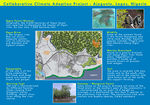
| Area | Ajegunle | |||||||||||
| Place | Lagos state | |||||||||||
| Country | Nigeria | |||||||||||
| Topic | Climate Change Impacts on Coastal Settlements | |||||||||||
| Author(s) | Kinga Jánossy, Melissa Abas and Fadera Williams | |||||||||||

| ||||||||||||
| {{#widget:GoogleMaps | width=300 | height=200 | lat=6.605 | lng=3.438 | zoom=10 | centermarker=no | maptypecontrol=yes | overviewmapcontrol=yes | largemapcontrol=yes | scalecontrol=yes
}} | ||
Rationale: Why have you selected this case study area?
- In African country like Nigeria, climate change has very big impacts to its sustainable development. Lagos, a state in the south part of Nigeria, is one example of area that is vulnerable to the influence of climate change. Therefore, widespread ecosystem degradation may occur, thus disrupting social-economic system, unless concerted and urgent action is taken.
- In Lagos state, poor people living on coastal area have high probability from flooding on heavy rainfall season. Settlement located in this risky area cope with influences such as property damage, temporary homelessness, and spread of illness due to unhygienic sanitation. Additionally, worst damage may occur due to the rising of sea levels and climate change.
- The study area is set in Ajegunle, it is located in Kosofe (local government area of Lagos state, Nigeria). The site is a major informal settlement, often described as ‘jungle city’ with a multi-ethnic population. It is evident that decent housing is a major problem of informal settlement dwellers. This is largely due to their low level of financial capacity coupled with inefficient land administration system which have further exclude them from urban life and increased their vulnerability to eviction, disaster and environmental health problem. Therefore, any attempt to achieve livable, healthy and prosper cities must as a matter of urgency address housing issue. This means that there must be a conscious effort focusing on provision of decent housing for the poor at an affordable rate.
Authors' perspectives
Climate change affects not only environmental problem, but also social, health, economic, and viability matter. Although Africa contribute only 3% emission for the global warming, it is more vulnerable due to the lack of infrastructure, technology, social and economy to manage its effect of global warming and climate change such as storm, flood, drought, land slide, etc. Within landscape architecture knowledge, approach to improve sustainable urban planning for adapting the challenge is necessary.
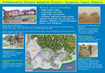
Urban context

- Lagos is the most populous city in Nigeria, the largest country in Africa. The metropolitan area, an estimated 300 square kilometers, is a group of islands endowed with creeks and a lagoon. In an effort to reduce massive urbanization in the metropolitan area, the Federal Government moved the capital to Abuja. Ajegunle has a population density of 7,941/km2.
- Energy and water access, sewerage, transportation and housing have all been adversely affected by haphazard development of a geographically disjointed city. Unlike the rest of Nigeria, 90% of the population of Lagos have access to electricity, with the city consuming 45% of the energy of the country. Despite the region's endowment of water, the city suffers from an acute and worsening water supply shortage. And due to inadequate sewerage, much the city's human waste is disposed of by the drainage of rainwater through open ditches that discharge onto the tidal flats.
- In Ajegunle, over 70% of the buildings in the area are Brazilian type while 13.1% of the buildings in Ajegunle are traditional compound type and 9.2% are flat. It is not surprising that most of the building are Brazilian buildings or rooming apartment because it is believed to be the main design and characteristics of low income group as well as poor communities in Nigeria cities. Most of the buildings (50.3%) are predominantly residential however, a significant proportion representing 40.5% of the buildings are mixed use while other land uses account for 9.2%.
- About 85.9% of the buildings are accessible by roads but, the main problem is that majority of the roads are not tarred and the conditions are extremely poor. The roads are characterized by poor drainage, lack of street lighting, absence of pedestrian walkway as well as on street parking. Also some of the roads are used as refuse dump site.
- The Dustbin Estate is a collection of shanties on refuse dump where a very poor set of people live in Ajegunle. Living on a large heap of rubbish poses a myriad of health hazards to both adults and the children, not neglecting the attendant environmental issues. Whenever there is rainfall, the situation is worsened as the entire ‘estate’ is soaked in flood and people still go about their normal duties in this deplorable state. One wonders how these people survive; they eat, drink, have their bath, sleep, talk and do virtually everything in this ever-smelly settlement. Some of them make money from charging people who dispose their refuse here, but one wonders if the income collected for each pack of refuse could ever sum up to justify and alleviate the prevalent abject poverty and hazardous living.
- GIS revealed a drastic expansion of developed areas in Lagos leading to a rapid loss of biodiversity and other forms of environmental degradation. This uncoordinated growth resulted into a mosaic of shanties/ blighted areas in many older areas of the city; Poorly serviced areas in terms of urban infrastructures such as roads, health centers, police stations, electricity, water, drainage systems, waste management, etc. (Rural-urban migration, poverty and sustainable environment: the case of Lagos, Nigeria prof. Peter ‘Bola Okuneye)
- Since 1985, state urban renewal plans have concentrated on upgrading the environment of slum communities by building roads and drainage channels and providing water supply, electricity, schools and health clinics. With cooperation from the citizens, success has been recorded in a number of pilot urban renewal schemes, which focus on building roads and drainage channels and providing water supply, electricity, schools and health clinics. (The Challenge of Urbanization: The World's Largest Cities, UN Publications)
Cultural/social/political context

- Lagos is a city and chief port in Lagos state, Nigeria. Until 1975 it was the capital of Lagos state, and until December 1991 it was the federal capital of Nigeria. Ikeja replaced Lagos as the state capital, and Abuja replaced Lagos as the federal capital. Lagos, however, remained the unofficial seat of many government agencies. The city’s population is centered on Lagos Island, in Lagos Lagoon, on the Bight of Benin in the Gulf of Guinea. Lagos is Nigeria’s largest city, which projected to be one of the world's five largest cities and one of the largest in sub-Saharan Africa.
- The Portuguese first landed on Lagos Island in 1472, while the area were settled by Yoruba fishermen and hunters, who called it Oko. Later on, from the late 16th century to the mid 19th century, the island was dominated by the kingdom of Benin, which called it Eko. The local obas (kings) enjoyed good relations with the Portuguese, who called the island Onim (and, later, Lagos) and who established a flourishing slave trade. British attempts to suppress the slave trade culminated in 1851 in a naval attack on Lagos and the deposition of the oba. The slave trade continued to grow, however, until Lagos came under British control in 1861.
- Originally governed as a British crown colony, Lagos was part of the United Kingdom’s West African Settlements from 1866 to 1874, when it became part of the Gold Coast Colony (modern Ghana). In 1886 it again achieved separate status under a British governor, and in 1906 it was amalgamated with the Protectorate of Southern Nigeria. When Southern and Northern Nigeria were amalgamated in 1914, Lagos was made the capital of the Colony and Protectorate of Nigeria. In 1954 most of the hinterland was incorporated into the region of Western Nigeria, while the city itself was designated as federal territory. In 1960 Lagos became the capital of independent Nigeria. Control of its hinterland was returned to the city in 1967 with the creation of Lagos state. After 1975 a new national capital, centrally situated near Abuja, was developed to replace Lagos, which by then suffered from slums, environmental pollution, and traffic congestion.
- Ajegunle falls under the Badagry Division and consists of people from all parts of the country with the dominant groups being the Ijaw, Ilaje, Hausa, Ibo, Urhobo and Yoruba ethnicity. The others are: Badagry, Ajara, Iworo-Ajido, Akarakumo, Gbaji, Aseri, Egan, Agarin, Ahanfe, Epe, Posi, Mowo, Itoga, Ebiri, Ekunpa, Aradagun, Berekete, Mosafejo, Gayingbo-Topo, Kankon, Moba, Popoji, Oranyan, Tafi-Awori, Yeketome, Ipota, Seme, Iyagbe, Ajegunle, Aiyetoro, Festac and Satellite Towns, Iba, Kirikiri, Agboju-Amuwo, Okokomaiko, Ojo, Amukoko, Alaba-ore, Ijofin, Igbanko, Imore, Ijegun, Odan Group of villages and part of Agara.
- According to Stoveland Consult, WTP Study of 1997, majority of the multi-ethnic population of Ajegunle are of school age and highly, economically productive. Their main occupation is trading in the formal and informal sectors.
- The Lagos metropolitan area is also a major educational and cultural centre. The University of Lagos (1962), the National Library, the Lagos City Libraries, and the National Museum (1957), with excellent historical examples of Nigerian arts and crafts, are all located in the city or its suburbs. The city is also the headquarters of the Federal Radio Corporation of Nigeria and the Nigerian Television Authority. The airport at Ikeja provides local and international services.
Landscape context

Topography
The topography of the area is generally low-lying undulating flat landform but with some very rugged areas having scalp slopes and gorges. The altitude varies from sea level to about 15 metres above sea level in some parts of Ogodu, Shaginshan and Magodo.
Soil
The area is covered with clay-sandy soil along the coastal axis in the south and clay- loamy soil at the interior part. Apart from the area still covered by forest, most of the clay- loamy soil of the interior have been seriously leached and presently look more like laterite soil. The soil are well drained with the exception of those found in the wetland areas.
Vegetation
The two major vegetation zones that can be identified on the watershed are the high forest vegetation in the north and central part and the swamp/ mangrove forests that covers the southern coastal and flood plains, next to the lagoon. The vegetation of the region is that of coastal swamp and marsh forest, part of which had given way to the construction of houses, markets and other infrastructures.
Hydrology
The major water bodies in the area includes River Ogun and the Lagos Lagoon in the southeastern part of the area. Other important water bodies, which traversed the area, includes the Majidun and Agboyi Rivers.
Climate Conditions


- The climate of the area is influenced by two air masses, namely: Tropical maritime and the Tropical continental air masses. The tropical maritime air mass is warm, wet and originates from the Atlantic Ocean. The tropical continental air mass is warm, dry, clusty and originates from the Sahara desert. Hence, the climate of the area is similar to that of the other coastal region of the tropical West Africa with tropical sub-equatorial climate. The temperature is high throughout the year with an annual mean maximum temperature of 33.27°C. while annual mean minimum temperature is 20. 27°C and the annual mean temperature is 26.77°C.
- The study area experiences two separate seasons, namely: the wet season, which runs from April to October with August being the little dry season period. The main dry season is from November to March. The area records an average annual rainfall of about 1830 mm, with maxima in June and September. Most rainfall experienced are of conventional origin: however.various disturbances contribute to the rainfall especially between February and May. The mean daily relative humidity of the area is 81.65%.
- According to one of the dailies, Ajegunle community has existed for 200 years and had been experiencing water level rise over the years. This is attributed to the climatic change and the release of water by Ogun-Osun River Basin Development Authority which manages the Oyan dam. The Oyan River Dam is in Abeokuta North local government area of Ogun State in the north of Nigeria, about 20 km northwest of the state capital Abeokuta. The dam crosses the Oyan River, a tributary of the Ogun River. It is used primarily to supply raw water to Lagos and Abeokuta, but has potential for use in irrigation and power generation.
- In May 2009, after heavy rainfall the dam operators were forced to release exceptional amounts of water from the dam for safety reasons, causing some flooding over an area of 2,800 hectares. This has been a yearly occurrence that leaves Ajegunle and its environment in flooding. The affected areas are Ikorodu, Agiliti, Ajegunle area of Ikorodu, Ojodu Berger, Odogun, Mandun, all in Lagos and Isheri, Maidan, Demo and Isheri in Ogun State. In 2007, water surge in the area led to the collapse of the only link bridge between Ikorodu and metropolitan Lagos.

- The Residents of the Ikorodu axis, comprising six local government areas, suffered untold hardships for months, experienced hectic traffic during the day and night while life generally became a disaster to most residents until the state government rebuilt the bridge. The flow of the ravaging water at Ajegunle, Itowolo and Majidun areas of lkorodu affected buildings because they were built on the right of way of River Ogun. hindering the free flow of the river into the lagoon. Whenever the river overflows it's banks water finds its way into the adjoining communities, causing flooding and destroying facilities like roads, infrastructures, buildings, disrupting business activities. In many areas, the effect was overwhelming. At Unity Street. a popular place in Ajegunle. the entire street was submerged by water, as well as Ifelodun street. In many other places, residents resorted to boarding canoes to get to their houses.
- In June 2012 unpredictable rain storms affects Ajegunle community. It has demolished many buildings and properties.
- Ajegunle has experienced a series of heatwave that runs from sunny afternoons through the night, which makes the impact felt during the night rest and it is tied to the intensity of rainfall this year, as predicted by the Nigerian Meteorological Agency.
Analysis of vulnerability


- Oceans, Seas, Islands and coastal areas form an integrated whole that is an essential component of the earth’s ecosystem and is critical to global food security and for sustaining economic prosperity and well-being of many National economies. Much of Nigeria’s population and economic activities are located along the coast with over 20% of the population inhabiting coastal areas of the 36 States in the country, 8 (Lagos, Ogun, Ondo, Edo, Delta, Bayelsa, Rivers, Akwa Ibom and cross River) of which are located in coastal zone.
- The topography of Lagos is dominated by its system of islands, sandbars, and lagoons. The city itself sprawls over four main islands: Lagos, Iddo, Ikoyi, and Victoria, which are connected to each other and to the mainland by a system of bridges. All the territory is low-lying, the highest point on Lagos Island being only 22 feet (7 meters) above sea level, and the average height in Lagos is 5 meters above sea level.
- The excessive and unpredictable rainfall pattern is due to rise in atmospheric temperature which is a result of ill-human activities accumulated over the years lead the coastal location of Lagos State prone to flooding.
- Despite the environmental challenge posed by flooding due to storm surges and heavy rainstorms exacerbated by urban development, the vulnerability of the growing rapidly urban poor has not been taken into consideration in urban planning and development.
- Millions of people living in Ajegunle, Asolo and Owode Onirin communities in Ikorodu area of Lagos State were expected to be evacuated and relocated to Agbowa camp by Lagos State government due to persistent flood that had ravaged the place. Apart from the overflowing of the Oyan River the government failed to produce enough channel, canals and gutters that allow easy passage of the flood water. The available drainage system provided are blocked by the waste tipped into them.
- If you consider these potential changes - which aspects/functions of your case study would be affected?
Proposals for Climate Change Adaptation
- Breakwater from Seawall, levees, and vegetation.
- Public enlightenment campaign to educate local residents on the importance of clearing drains and the adverse effects of dumping their wastes in drainage channels.
- Reducing vulnerabilities of essential infrastructure and communities;
- Promoting green infrastructure influenced integrated river basin management including ecological water management;
- Protecting urban forests made upof patches, wetland on flood plains and riparian vegetations along water corridors.
- Restoring wetlands and promoting low-carbon development.
- How could your case study area become more resilient to climate change?
- Which measures would need to be taken to adapt to the new situation?
- How could you assure sustainability of these measures?
- Please describe 2-3 measures
Proposals for Climate Change Mitigation
- Promotion of green infrastructure as an environmental protection tool with emphasis on safeguarding physical developments from inherent natural disasters, securing life, properties, and protecting coastal biodiversity.
- People oriented disaster mitigation and recovery scheme occupy the center stage of action area physical planning. Such planning introduces the community toward actions protecting their lives, properties, empowerment that minimizes the risk of loss and improves quality of life.
- Plant trees to reduce greenhouse gas emissions and create water absorption on the ground.
- Which measures would need to be taken to reduce greenhouse gas emissions and other drivers of climate change within your case study area?
- How could you assure sustainability of these measures?
- Please describe 2-3 measures
Your scenario
- How will this area look like in 2060?
- Please forecast one potential future development taking climate change into account
- Turning waste to energy
Illustration: Map/diagram/sketches photos and background notes
What can be generalized from this case study?
- Are there any important theoretical insights?
- Which research questions does it generate?
- Short statement plus background notes
Presentation Slides
-
 Slide One
 -
 Slide Two
 -
Slide Three


Image Gallery
-
your image text
-
your image text
-
your image text
-
your image text
-
your image text
-
your image text
-
your image text
-
your image text
References
Please add literature, documentations and weblinks
http://www.britannica.com/EBchecked/topic/327849/Lagos
http://234next.com/csp/cms/sites/Next/Home/5728697-146/ajegunle_leaders_meet_to_tackle_climate.csp
About categories: You can add more categories with this tag: "", add your categories
{{#widget:WidgetName|param1=value1|param2=value2}}