Group D - Collaborative Climate Adaption Project: Difference between revisions
| Line 60: | Line 60: | ||
=== | === '''LOCAL CLIMATE''' === | ||
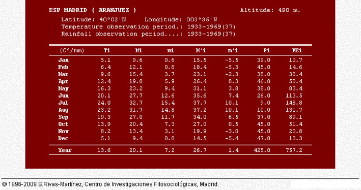
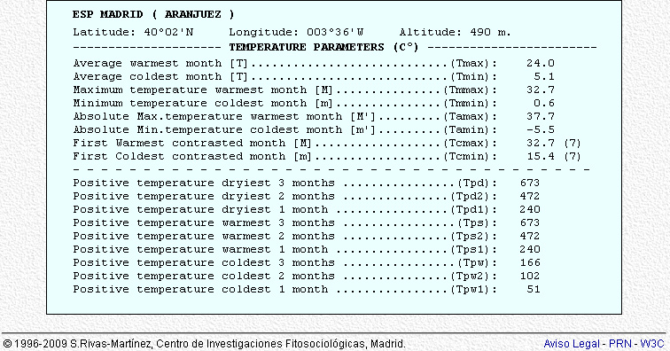
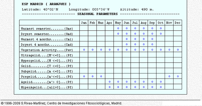
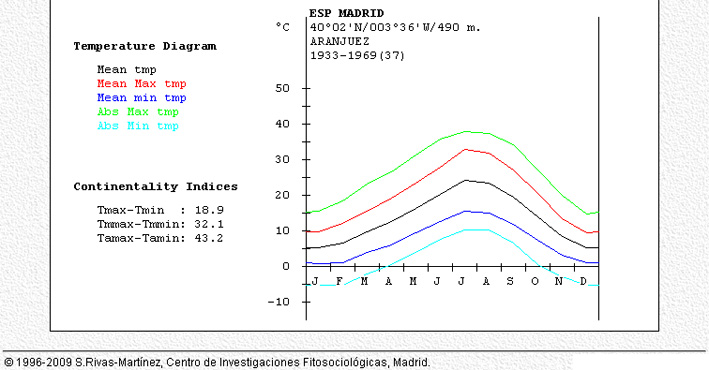
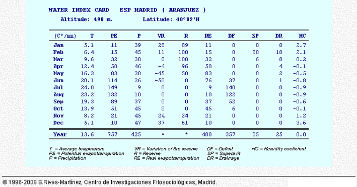
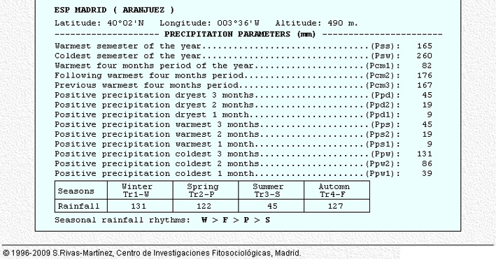
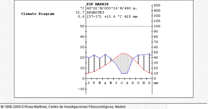
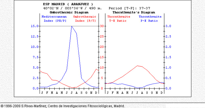
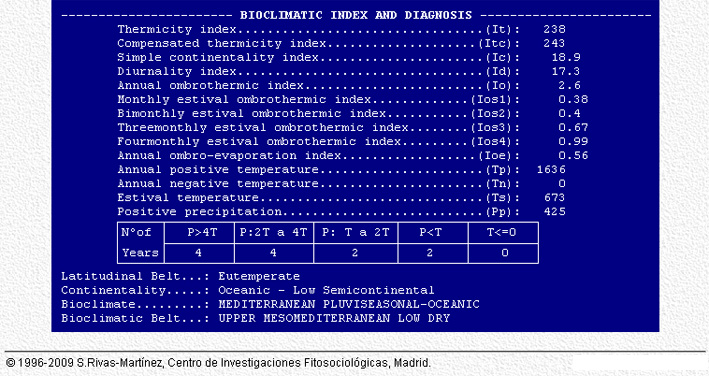
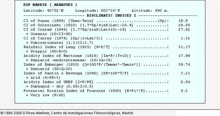
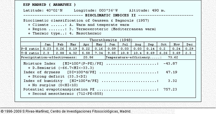
== Climatic Data Period 1933-1969 == | == Climatic Data Period 1933-1969 == | ||
Revision as of 17:37, 11 January 2013
| Area | Aranjuez | |
| Country | Spain | |
| Topic | Effects of climate change and adaptation possibilities - case study from Aranjuez, Spain | |
| Author(s) | Eduardo Casado Fernández, Fang Yi, Daniela Staykova | |

| ||
|
| ||
Rationale: Why have you selected this case study area?
- Aranjuez is a town and lying 48 km south of Madrid in the southern part of the autonomous community of the Community of Madrid.
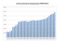
As of 2009, it has a population of 54,055. It is in the Wolrd Heritage List as Cultural Landscape. Climate change is affecting the gardens which are one of the most important elements of the cultural landscape and is affecting the massive trees, mainly specimens of Platanus x hispanica(more than 20-30 m high), and either urban planning is not being helpful either. There are also some other important problems, that should be addressed as soon as possible e.g. the nightmare of the access to the city and its collateral effects.
Authors' perspectives
- As landscape architecs we have an important role to play defining policies (i.e. urban ordinances) designing and applying strategies to improve urban design to preserve the core value of the Cultural Landscape of Aranjuez represented by the historical Gardens of Aranjuez linked to the Royal Palace. Also it is necessary to define policies for landscaping and integrating vegetation regarding other places of the city.
LANDSCAPE AND/OR URBAN CONTEST
Population In Aranjuez
- Biogeography, land use patterns, cultural features, overall character, history and dynamics
- ratio of green/blue and sealed/built-up areas
Illustration: Map; sketches; short descriptive analyses
Cultural/social/political context
- Brief explanation of culture, political economy, legal framework
Illustration: Bullet points, image, background notes
LOCAL CLIMATE
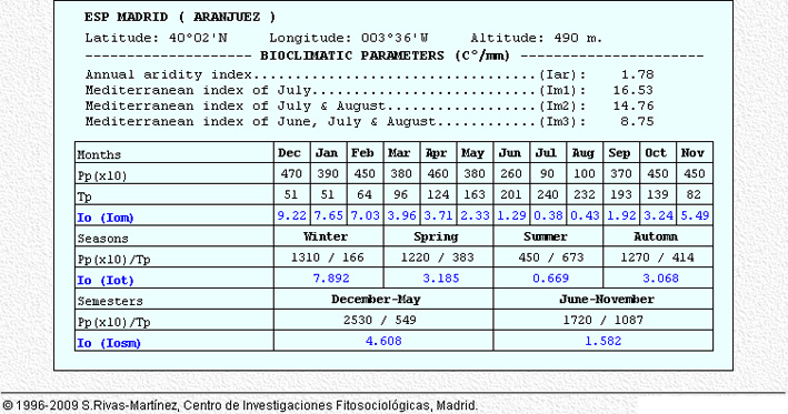
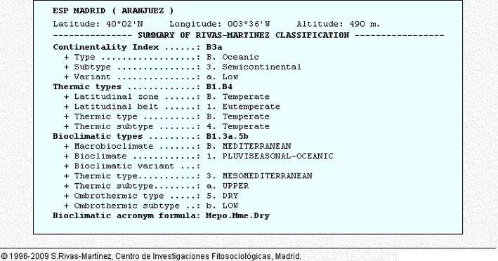
Climatic Data Period 1933-1969
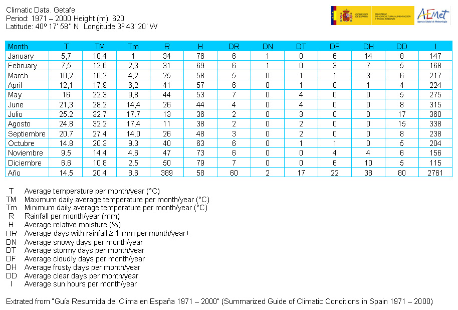
Climatic Data Period 1971 -2000 (Getafe Weather Station)
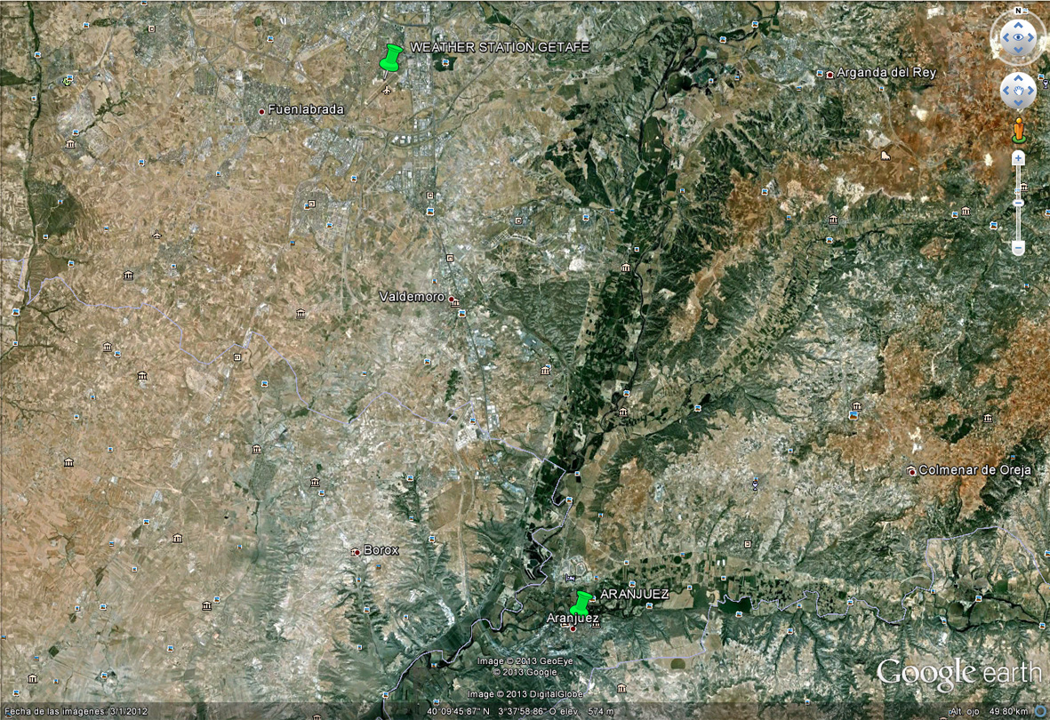
Getafe - Aranjuez Location
Getafe Climatic Data
Aranjuez Average Climate Data up to 2009
Have there been extreme weather events in the near past?
- Which changes are expected? Is there any evidence?
Illustration: Table or time line
Analysis of vulnerability
- If you consider these potential changes - which aspects/functions of your case study would be affected?
Illustration: Map/diagram/sketches/photos/background notes
Proposals for Climate Change Adaption
- How could your case study area become more resilient to climate change?
- Which measures would need to be taken to adapt to the new situation?
- How could you assure sustainability of these measures?
- Please describe 2-3 measures
Proposals for Climate Change Mitigation
- Which measures would need to be taken to reduce greenhouse gas emissions and other drivers of climate change within your case study area?
- How could you assure sustainability of these measures?
- Please describe 2-3 measures
Your scenario
- How will this area look like in 2060?
- Please forecast one potential future development taking climate change into account
Illustration: Map/diagram/sketches photos and background notes
What can be generalized from this case study?
- Are there any important theoretical insights?
- Which research questions does it generate?
- Short statement plus background notes
Presentation Slides
- Addnewimagename.jpg
Slide One
- Addnewimagename.jpg
Slide Two
- Addnewimagename.jpg
Slide Three
Image Gallery
- Yourimage.jpg
your image text
- Yourimage.jpg
your image text
- Yourimage.jpg
your image text
- Yourimage.jpg
your image text
- Yourimage.jpg
your image text
- Yourimage.jpg
your image text
- Yourimage.jpg
your image text
- Yourimage.jpg
your image text
References
Please add literature, documentations and weblinks
About categories: You can add more categories with this tag: "", add your categories
