Group O - Collaborative Climate Adaption Project: Difference between revisions
| Line 147: | Line 147: | ||
[[File:Ackermannbogen 3D Darstellung.JPG|300px|left|thumb]][[File:Ackermannbogen Luftbild von 1990.JPG|300px|none|thumb]] | [[File:Ackermannbogen 3D Darstellung.JPG|300px|left|thumb]][[File:Ackermannbogen Luftbild von 1990.JPG|300px|none|thumb]] | ||
source: http://www.ackermannbogen.de/wiki/Geschichte | source: http://www.ackermannbogen.de/wiki/Geschichte | ||
Revision as of 10:23, 5 January 2013
| Area | Munich | |||||||||||
| Place | Ackermannbogen | |||||||||||
| Country | Germany | |||||||||||
| Topic | renewable energy application | |||||||||||
| Author(s) | Cenke Jiang, Andreea Pascu, Le Trang Nguyen | |||||||||||

| ||||||||||||
| {{#widget:GoogleMaps | width=300 | height=200 | lat=48.136607 | lng=11.577085 | zoom=11 | centermarker=yes | maptypecontrol=yes | overviewmapcontrol=yes | largemapcontrol=yes | scalecontrol=yes
}} | ||
Rationale: Why have you selected this case study area?
- Munich is the capital city of Bavaria, one of Germany's three largest cities with the population of 1.42 million people and has the strongest economy of the whole country. This is a globally cosmopolitan city and also has the leading renewable energy policy.
- Ackermannbogen is a district of Munich particularly planned to be one of the front-runners of solar district heating. This is a part of the city's aim: 100% renewable energy for Munich in 2015. This area is a perfect practical example of building a green enery system and an innovative concept of intergrating solar heating machines with green space.
Authors' perspectives
We all come from different background, but our aspirations meet where the climate is actually changing and we believe renewable energy and mitigation is the key solution for the future. We chose Ackermannbogen as a project-case study, more than a reality-case study, because it is a great project which was designed and currently being built and continually adjusted for the future. Our aim is to learn from such massive plan and to make our own proposals in the context of pre-designed but considering the factor of climate changing.
Landscape and/or urban context
In the late eighties, the city of Munich laid the foundation stone for a municipal policy committed to promoting renewable sources of energy by emphasising energy saving. As early as 1991, the Munich municipal council decided to concentrate on lowering CO2 emissions by 30% in 2005 and by 50% in 2010. So far, the City of Munich's climate protection policy has respected Kyoto protocol objectives even though this was not the case before they were defined.
Ackermannbogen district is situated within the context of the pre-planning area, Munich Olympic Park. Along with the whole concept of "Green Olympic Games" and the energy saving policy of Munich itself, Ackermannbogen specifically generates solar-powered local heating system with a seasonal heat storage facility has been developed for the Bavarian capital of Munich. The concept actually came from a competition of urban and landscape design ideas in 1998, conducted by the city of Munich. The central idea of the design was to create a community planner broad range of different types of housing - from double or terraced houses to apartment buildings.
Biogeography
The planning area is located in the Munich gravel plain on the terraces of the Würm glaciation. It is flat and inclined slightly from 514m in the north to 513m in the south.
The most important for this work natural environment bases from the site report by Dragomir, Stahr and Naberland are (1995) summarized:
• Ground
On the ground conditions in the narrow city there are no statements of location-known 'land map, because the soils in the city mostly by dumping of strange substances and building materials which are no longer in its natural state.
• Groundwater
The ground in the planning area, as well as the entire Munich gravel plain, is very porous and therefore has significant groundwater resources, including drinking water supply. From the built-over and paved surfaces, the surface water flows through sewerage drains, the river Isar supplies and directs water from the urban area . It is therefore very important to keep in newly developed areas the soil sealing as little as possible.
• Climate
There is low weather exchange from the south and the east due to weak winds, since the planning area is bordered by densely built-up and busy streets. Only the meadows of the Olympic mountain can be seen as the original area of unpolluted cold air. Especially in weak-wind radiation nights, fresh air can flow from the Olympic mountains towards the center of the area.
A climate-ecological balance function also exerts from the meadows and the richly textured mature trees on the site plan.
• Trees
In the planning area, there are valuable trees, which mainly consists of about 60-80 years old sycamore and Norwegian maples and lime trees. The trees have mostly good vigor and a magnificent disposition, most are under the Munich Tree Protection Ordinance (trunk circumference> 80 cm, height> 1m).
• Habitats
There is a former heliport in the planning area. It consists of a gravel surface on which a dry vegetation has developed over the years developed, bordered by woodland nursery. In 1981 this area was mapped as a 0.7 ha sized legitimate habitat. Since then the habitat has expanded twice as large.
In the south of the Olympic Park there are poor grassland habitats on former railway land and extensive sand hill areas. Between habitats through the narrow neighborhood of the former helipad is a floristic and faunal exchange. The area of the helipad has therefore the ecological value of a stepping-stone habitat.
• Fauna
Conspicuously on the planning area is the birdlife, which is mainly due to the old trees with its richly structured tree groups adjacent to Olympic Park. Among others it is possible to spot species of blackbirds, chickadees, spotted woodpeckers, pheasants, ducks and hawks.
Rare animals can be found primarily in the area of the former helipad. The animal varies from various ants, butterflies and grasshoppers.
Land use
Within the Urban Development Action, till 2014 Ackermannbogen will then cover 39.5 hectares in total:
- ca. 2250 dwellings
- Student dormitory
- Kindergarten
- Public primary school
- Private school
- Medical centre
- Supermarket
- Retails, Cafeterias
- Cultural and neighborhood meeting
- Bridge Construction
- 9.2 hectares of public green spaces
- Large meadow
- Playground
- Hills
- City Forest
Overall character

The project area is located in the northern part of the district Neuhausen-Oberwiesenfeld in the north of Munich, close to the southern edge of the Olympic site and connects directly to the Schwabing district. It is bounded by the Ackerman Road to the west and north, the Deidesheimer, Saar and Winzererstraße the east and Schwere–Reichter–Straße in the south.
In the south of the Schwere–Reichter–Straße, there is another smaller and still unused barracks (Luitpold barracks), a small, self-contained residential development and several gas stations. Following this is an area with offices and public facilities extends (Infantry, Hess, Loth and Dachauerstraße).
The district Schwabing-West is in the east of the project area is a dense block development area. Further north is the Middle Ring, Frankfurter Ring and the business and industrial belt at Frankfurter Ring Barrier, an urban landscape lying there on the clearance.
This central location is near to the park and also requires attracktive planning for residents and visitors, which is challenging due to the expected high use pressure.
History and dynamics
The history of the whole area comes from the land named Oberwiesenfeld. Since the end of the 19th century, Oberwiesenfeld area had been the landing for balloons and airships, both military and civilian. Till 1902 Prince Luitpold established the Prince Leopold Barracks from Infanterie Road to Schwere-Reiter Road, which forms today the southern tip of the planning area. By the corner of Schwere-Reiter Road and Winzerer Road is the reserved historical buildings, including the Department of Transportation (Straßenbauamt), the State Archives (Staatsarchiv) and a canteen is located.
Adjacent to the planning area to the north of the Dachauer Road was the area of the railway company since 1890, which are currently erected the buildings of Munich’s Military District and Site Management and the district recruiting office. Since 1896, a new barrack was built in the south of Schwere-Reiter Road, at the corner of Heß Road and an airship department was located, which was later expanded to Luitpold barracks by the Nazis. In 1909, a small condominium for army officials was built in the south of Schwere-Reiter Road, at Barbara Road and still reserved till today. Also under the Nazis time the military had added to existing military building regulations: in 1933, the first part of the "motorcycle-shooters-barracks" (Kraftrad-Schützen-Kaserne) was built in the west of existing Prinz-Leopold barrack. Since 1935 the New-corps barrack existed, today known as Waldmann barrack. Here till the 2nd World War was the accommodation of infantries, pioneers, signal corps and drivers. After the end of the 2nd World War, the planning area was only slightly damaged and installed some facilities as emergency shelters for refugees and expellees; they also have been used temporarily for commercial purposes.
The barracks were occupied by U.S. forces from 1945 to the late 50s and then claimed against the Federal Army Force. New supplemental buildings were added gradually to the site of the Stetten barracks in the 60s: Auditorium buildings, dorm and gymnasiums. In the same period in the middle of the site was the central heating plant with brick chimney to look similar to the whole area’s style. The Waldmann barracks were removed from the grounds for that purpose.


After the 2nd World War II till 1951, in the south of the Nymphenburg Biederstain-channel a 40-meter high pile of debris from the war’s ruins, was dumped. This separated the south-eastern part of the Oberwiesenfeld and the spatial connection between this area (nowadays planning area) and the rest of Oberwiesenfeld is lost.
In April 1966 in Rome, Munich was decided to host the Olympic Summer Games '72. The pile of debris was used in the landscaping concept of Olympic facilities. The Olympic Park was completed in June 1972. Since 1972, the northern (and largest) part of the upper meadow area merged into Munich Olympic Park.
Then for the area under the name "am Ackermannbogen" urban planning began to reflect a part of the Prince Leopold Barracks, both of which are currently completed three sections. After the construction of the first section in the north east of the site, the building of the Department of Military Geography (MilGeo) which had been abandoned by the army then was reconstructed. In 2006/07 the former barracks building in the Stetten barracks were pulled down, whereupon the fourth section will be built next to the student dormitory at Schweren-Reiter street.
Based on the urban contract and development agreement between the property owners and the City of Munich, in the fall of 2002 the first section of the development and the construction of housing in Ackermannbogen started. The northeast neighborhood was constructed under the "Bavarian Future", a residential support program of the Free State of Bavaria, which implemented as a "model village" to try new ways of cost, environmental and social living in Bavaria. Here approximately 630 homes, a mixture of various types of houses and apartments, as well as a daycare center were realized. Another building on the north end of the large lawn with an integrated cooperative system for children is expected to be ready in spring 2007.
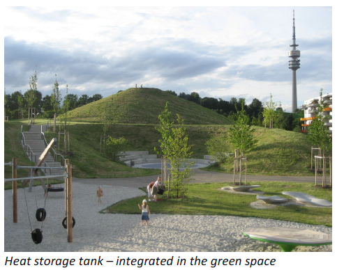
The third section (North-West district) is the model project implemented Solar local heating, or solar thermal energy and district heating. Three large underground storage tanks were placed to supply approximately 300 residential units.
In the south (second section), particularly along Schwere-Reiter street and in the northern part of the Adams-Lehmann-street, next to social housing and public service and high-priced condominiums, a health clinic and a day care center are planned.
In the southwest (fourth section, there is a "market square" and the shops and stores are grouped so that the new district is supplied accordingly. In this area there will be sheltered housing for the arising elderly. An existing building on the Schwere-Reiter street was converted into a dormitory. The development plan for the fourth section is still being considered and not decided yet.


source: http://www.ackermannbogen.de/wiki/Geschichte
Ratio of green/blue and sealed/built-up areas
Illustration: Map; sketches; short descriptive analyses
Cultural/social/political context
- Brief explanation of culture, political economy, legal framework
Illustration: Bullet points, image, background notes
Local Climate
- What are the climatic conditions at present? Have there been extreme weather events in the near past?
- Which changes are expected? Is there any evidence?
Illustration: Table or time line
Analysis of vulnerability
- If you consider these potential changes - which aspects/functions of your case study would be affected?
Illustration: Map/diagram/sketches/photos/background notes
Proposals for Climate Change Adaption
- How could your case study area become more resilient to climate change?
- Which measures would need to be taken to adapt to the new situation?
- How could you assure sustainability of these measures?
- Please describe 2-3 measures
Proposals for Climate Change Mitigation
- Which measures would need to be taken to reduce greenhouse gas emissions and other drivers of climate change within your case study area?
Through our discussion,we consider that climate change mitigation in our case study area depend on not only the application of solar energy, but also any possible details of measures on sustainable use of resources, reducing the carbon footprint of individuals, creating urban carbon sinks, reducing the urban heat island effect and supporting biodiversity.
- How could you assure sustainability of these measures?
The fundamental of a city is make up of people and infrastructure, no matter green infrastructure oder water-supply and drainage infrastructure and so on. The whole of production and consumption must be need energy to transform, reserve and produce. Therefore, energy theme is first and foremost and lang-term question to solve. Only through using all the available methods from two aspects, energy-consumption reduction and self sufficiency, to applying can area sustainable development, while the question of energy is always existing .
- Please describe 2-3 measures
'In Ackermannbogen, inhabitants can don' t need one car, and if you ever do, there is a car-sharing station here in the district. You can live in a leafy green area in the city centre largely free of exhaust fumes, traffic and noise. This is a model that may turn out to be a blueprint for the future if the inhabitants do their bit.
'Rainwater collection device installed on each building,what's more connection with the watering system of urban green space,at the same time in the direction of the sunny construct the plant wall. As far as possible do not waste any little resource, as well as make most use of it.
Your scenario
- How will this area look like in 2060?

By 2060 Ackermannbogen will turn into a vibrant energy self-sufficient ZEROcarbon city, which is access to balance between energy demand and request. At same time it will create a optimized status among the quantity of inhabitants and houses and the job opportunities.
- Please forecast one potential future development taking climate change into account
The future development of climate change in this area will probably emphasize on maximized natural oxygen bar. What's more, according to the biodiversity is totally large increasing, it will become a excellent habitat for animal and vegetation. Furthermore, people live in a harmonious and sustainable environment, not to mention natural disasters.
What can be generalized from this case study?
- Are there any important theoretical insights?
Ecological Evaluation
equivalent CO2-emission of solar installation 222 t/a
reduction related to condensing boiler system 213 t/a
reduction related to conventional district heating 150 t/a
- Which research questions does it generate?
'Public acceptance: This case would need to develop a well communicated strategy to convince stakeholders of the option of 100%. Citizen should feel they are rewarded financially. A zero loan subsidy was suggested as an option for retrofitting households with energy efficiency and renewable measures.
'The financing tools: to take public&private partnerships between the city,banks, energy service companies and households to engaging
'The relationship between with other districts and regions is hardly balance, it will more and more people come Ackermannbogen working, there will be a large number of commuter. But you can not restrict the growth of the urban economy, so it must long-term consider the development city and neighborhood.
- Short statement plus background notes
This case focuses on seasonal storage of the heat collected with solar panels and was lauched in 2007 after almost 10 years of preparation. This area is a perfect practical example of building a green energy system and an innovative concept of integrating solar heating machines with green space.
Presentation Slides
-
Slide One
-
Slide Two
-
Slide Three
Image Gallery
-
your image text
-
your image text
-
your image text
-
your image text
-
your image text
-
your image text
-
your image text
-
your image text
References
Please add literature, documentations and weblinks
http://www.zaharias.net/wb-ackwohn.php?lg=en
http://www.docstoc.com/docs/46703256/Planning-Implementing-and-Monitoring-of-Large-Solar-Projects
http://www.eubia.org/uploads/media/EUSEW_CA-EUBIA_event-_summary.pdf