Group J - Collaborative Climate Adaption Project: Difference between revisions
| Line 92: | Line 92: | ||
Historically the high water was characteristic to Venice in spring and autumn with its peaks in November and December. Nowadays the situation has changed and the flood events occur around 60 to 100 times a year. The severest flood in the history of Venice was experienced in 1966 when the level of the lagoon rose 194 cm above its normal level. In 2012 Venice experienced exceptional high waters even twice. [[http://www.latimes.com/entertainment/arts/culture/la-et-cm-climate-change-venice-floods-20121113,0,3592602.story]] | Historically the high water was characteristic to Venice in spring and autumn with its peaks in November and December. Nowadays the situation has changed and the flood events occur around 60 to 100 times a year. The severest flood in the history of Venice was experienced in 1966 when the level of the lagoon rose 194 cm above its normal level. In 2012 Venice experienced exceptional high waters even twice. [[http://www.latimes.com/entertainment/arts/culture/la-et-cm-climate-change-venice-floods-20121113,0,3592602.story]] | ||
The climate change | The climate change significantly influences the air circulation of the North hemisphere. Those changes manifest as the heat waves and extreme pressure differences that increase the strength of Sirocco Winds resulting as more frequent and disastrous floods in Venice. | ||
Accordingly to the European Environment Agency Venice, same as the majority of the Mediterranean region, will experience a significant increase of heat waves combined with a temperate decrease of precipitation during this century. The global warming will also have a serious impact on the rise of the sea level that in accordance with the latest IPCC (Intergovernmental Panel on Climate Change) report can reach 88 cm in the worst-case scenario [[http://www.scientificamerican.com/article.cfm?id=saving-venice]]. | Accordingly to the European Environment Agency Venice, same as the majority of the Mediterranean region, will experience a significant increase of heat waves combined with a temperate decrease of precipitation during this century. The global warming will also have a serious impact on the rise of the sea level that in accordance with the latest IPCC (Intergovernmental Panel on Climate Change) report can reach 88 cm in the worst-case scenario [[http://www.scientificamerican.com/article.cfm?id=saving-venice]]. | ||
Revision as of 19:32, 18 December 2012
| Area | Venetian Lagoon | |
| Place | Venice | |
| Country | Italy | |
| Topic | Subsidence of Venice | |
| Author(s) | Alisan Gül, Anna Slosberga, Lena Penezic | |

| ||
|
| ||
Rationale: Why have you selected this case study area?
- Please summarise:- e.g. previous experience, is it your everyday environment?, specific vulnerability, previous research being done etc.
Venice is a World heritage City. It is rich of historic architecture and have its own culture within Italy. Because of the city's architectural, historic and culture importance we have selected the lagoon of Venice. The underground of the lagoon is sinking, the lagoon's ecosystem is destroyed and the Ciy of Venice is endangered to go down in few years. This process is speed up by the increasing sea levels caused by the climate change. An important aspect is that a great part of the existing danger was caused by manhand. This disaster began earlier as the Venetians began to pump down a great deal of groundwater and this result a rapid sinking of the underground of Venice. The building of shipping channels under the lagoon destroyed the ecosystem of the lagoon and one more aspect for subsidence of the underground of Venice For safeguarding the Venetian lagoon there are some plans from firms like CREA and and a project M.O.S.E.
Authors' perspectives
- What theoretical or professional perspective do you bring to the case study?
Unfortunately people notice danger very late and Venice is a good example of the humans irresponsibility towards the nature and the environment. As the City was built on the weak underground of the lagoon, it has deformed the functions of the lagoon and destroyed the local ecosystem. In general the same imprudence can be observed in terms with the global environment. For instance many countries still can not efficiently reduce the GHG's to mitigate the climate change. We would like to believe that our case study area can inspire the people to see the destruction made by the man-hand and the irresponsibility of our society in general.
Landscape and/or urban context
Venice (Latin: Venetia)) is a city in northeast Italy sited on a group of 118 small islands separated by canals and linked by bridges. It is located in the marshy Venetian Lagoon which stretches along the shoreline between the mouths of the Po and the Piave Rivers, rather from the Sile on the north and the river Brenta on south. The whole area is listed as a World Heritage Site, UNESCO. Venice is the capital of the Veneto region which consist the whole Comune of Venezia;the historic city of Venice (Centro storico); Terraferma (the Mainland), Mestre and Marghera. Together with Padua and Treviso, the city is included in the Padua-Treviso-Venice Metropolitan. As it can be seen , Venice is an overbuilt island, known as the ' Floating City which has no greater green areas or green infrastructures. Venezia is a city of small islands, enhanced during the Middle Ages by the dredging of soils to raise the marshy ground above the tides, so it's a manmade landscape. The resulting canals encouraged a nautical culture, which provided central development of the city. Today those canals (more than 400) still provide the means for transport of goods and people within the city. Acqua alta (Italian: 'high water') is the term used in Veneto for the exceptional tide peaks that occur periodically (autumn and spring) in the northern Adriatic Sea. The peaks reach their maximum in the Venetian Lagoon, where they cause partial flooding of Venice and Chioggia.
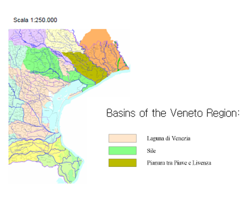
Map from: http://www.arpa.veneto.it/temi-ambientali/acqua/acque-interne/bacino-scolante-
Lagoon – lat.lacus, "lake" –international name for an enclosed, shallow embayment of salt water. The drainage basin, also known as ‘’ Il bacino scolante’’ is the area where the surface water network (under conditions of normal flow )flows in the lagoon of Venice.The surface of the drainage basin is composed of two areas:the territories of the tributaries of the river basin surface waters which open in the lagoon of Venice;the territories that affect water bodies draining of the lagoon of Venice by the spring waters, identified as Charge Area
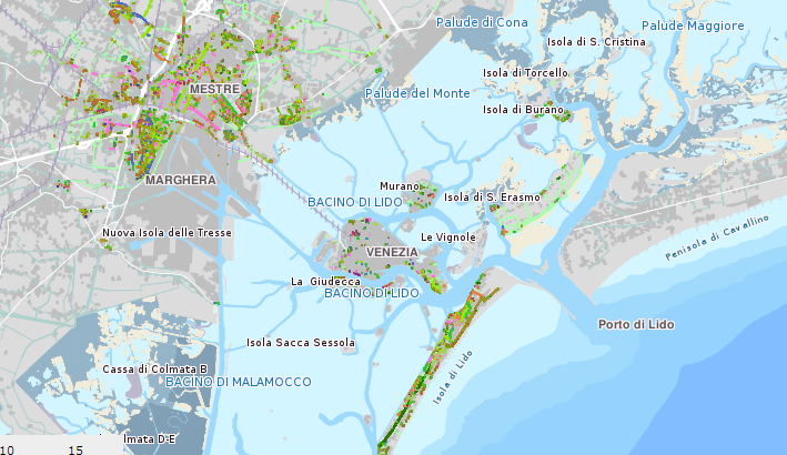
The Map shows the greenery of the area of Veneto. As can be seen Venice consist of dense urban tissue and almost no green stuctures at all. There are some trees marked, and some open spaces on the south coast
ARPAV recognize four types of Water in the region: Inetrnal waters, Transitional, Coastal and Bathing Waters http://www.arpa.veneto.it/temi-ambientali/acqua
- Biogeography, land use patterns, cultural features, overall character, history and dynamics
- ratio of green/blue and sealed/built-up areas
Illustration: Map; sketches; short descriptive analyses
Cultural/social/political context
- Brief explanation of culture, political economy, legal framework
Illustration: Bullet points, image, background notes
Local Climate
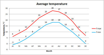
The climate in Venice is Mediterranean, but due to the surrounding sea it is rather wet throughout the year. Venice`s tempered climate is characterized by mild temperatures that rarely go under 0°C in winter and above 35°C in summer time. The average precipitation in Venice is 854 mm per year[[1]].
The two most important winds blowing over Venice are Bora and Sirocco. Both can be observed at all seasons. Bora is a dry and cool wind blowing from the north-east while Sirocco is a humid and warm wind blowing from the Sahara desert. Sirocco along with the lunar cycles and the Adriatic tides is responsible for the phenomenon of acqua alta (high water).
Historically the high water was characteristic to Venice in spring and autumn with its peaks in November and December. Nowadays the situation has changed and the flood events occur around 60 to 100 times a year. The severest flood in the history of Venice was experienced in 1966 when the level of the lagoon rose 194 cm above its normal level. In 2012 Venice experienced exceptional high waters even twice. [[2]]
The climate change significantly influences the air circulation of the North hemisphere. Those changes manifest as the heat waves and extreme pressure differences that increase the strength of Sirocco Winds resulting as more frequent and disastrous floods in Venice.
Accordingly to the European Environment Agency Venice, same as the majority of the Mediterranean region, will experience a significant increase of heat waves combined with a temperate decrease of precipitation during this century. The global warming will also have a serious impact on the rise of the sea level that in accordance with the latest IPCC (Intergovernmental Panel on Climate Change) report can reach 88 cm in the worst-case scenario [[3]].
- What are the climatic conditions at present? Have there been extreme weather events in the near past?
- Which changes are expected? Is there any evidence?
Illustration: Table or time line
Analysis of vulnerability
The flooding caused by the acqua alta is not uniform throughout the city of Venice because of several factors, such as:
1. the varying altitude of each zone with respect to the conventional sea level,
2. the distance from a channel,
3. the relative height of the sidewalks,
4. the presence of full parapets (which act as dams) along the proximate channel,
5. the layout of the sewer and water drainage network (which acts as a source for the flooding, as it is directly connected with the lagoon).
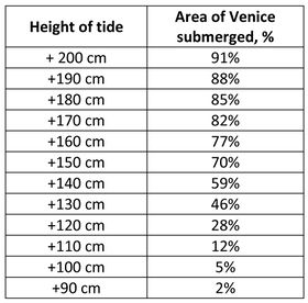
The studies have shown that tides up to 90 cm above sea level leave Venice virtually unaffected. The sirens that forecast high water 3-4 hours in advance go off if the level is expected to be above 110 cm because with this height 12% of Venice is covered with water. The studies have provided the correlation between the sea level and the percentage of submerged area of Venice [[4]] .
The previously described worst-case scenario regarding the sea level rise of 88 cm within this century due to the climate change would lead Venice to very high and exceptional high tides almost daily. Meaning that without appropriate adaption measures more than 50% of Venice would constantly lie under the water causing irreversible all-inclusive damage effecting citizens daily life, architectural and cultural values, economics etc.
- If you consider these potential changes - which aspects/functions of your case study would be affected?
Illustration: Map/diagram/sketches/photos/background notes
Proposals for Climate Change Adaption
 [[5]]
[[5]]
The Mo.S.E. (Modulo Sperimentale Elettromeccanico, or Experimental Electromechanical Module) Project has been created to protect Venice against the floods. It involves the construction of a set of 79 floodgates that will separate the lagoon from the Adriatic. The engineering solutions of those devices will provide no negative effects on the vistas of Venice as the gates are designed to lie flat on the seabed and are planned to be risen only during the extremely significant tides. [[6]] Although the Mo.S.E Project will probably prevent the unique architectural and cultural sites of Venice from going under the water it is also predicted to cause an irreversible damage to the local ecosystems of the lagoon. As the mobile floodgates are under construction according to the Mo.S.E Project, the ecosystems of the lagoon have become the most vulnerable value that now is put under the considerable risk.
Another process to safeguard Venice is:
- to raise fondamentes
- to reduce depths at the 3 entrances of the lagoon
- restore wetlands
- redesign jetties to slow tides
And anaother project which can be effective and sustainable to stop the subsidence ist to inject sea water under the underground of Venice. "The seawater would be pumped into a number of sandy layers ... between 650 and 1,000 meters' depth ..he said. "The presence of a clay cover above ensures that the injected seawater will not flow upward. Water will diffuse laterally within the layers it is pumped into.", Gambolati, a hydrologist at the University of Padua in Italy.
Under the plan, a dozen wells surrounding Venice in a ten Kilometer circle would pump water into the ground over a ten-year period—nearly 40 150 billion liters. The plan is also economical certainly in comparison with the MOSE system. This porject of injection would raise the city by 25–30 cm over 10 years. [[7]]
- How could your case study area become more resilient to climate change?
- Which measures would need to be taken to adapt to the new situation?
- How could you assure sustainability of these measures?
- Please describe 2-3 measures
Proposals for Climate Change Mitigation
- Which measures would need to be taken to reduce greenhouse gas emissions and other drivers of climate change within your case study area?
- How could you assure sustainability of these measures?
- Please describe 2-3 measures
Your scenario
- How will this area look like in 2060?
- Please forecast one potential future development taking climate change into account
Illustration: Map/diagram/sketches photos and background notes
What can be generalized from this case study?
- Are there any important theoretical insights?
- Which research questions does it generate?
- Short statement plus background notes
Image Gallery
- Yourimage.jpg
your image text
- Yourimage.jpg
your image text
- Yourimage.jpg
your image text
- Yourimage.jpg
your image text
- Yourimage.jpg
your image text
- Yourimage.jpg
your image text
- Yourimage.jpg
your image text
- Yourimage.jpg
your image text
References
Climate of Venice. Retrieved December 11, 2012 from the Italy-trip Website at: http://venice.italy-trip.org/climate-venice.html
Knight C., Venice floods attributed to climate change. Los Angeles Times, 2012. Retrieved December 11, 2012 from The Los Angeles Times Website at: http://www.latimes.com/entertainment/arts/culture/la-et-cm-climate-change-venice-floods-20121113,0,3592602.story
Merali Z., Saving Venice. An ambitious plan seeks to prevent a modern Atlantis. Scientific American, 2002. Retrieved December 12, 2012 from The Scientific American Website at: http://www.scientificamerican.com/article.cfm?id=saving-venice
Le percentuali di allagamento. Retrieved December 17, 2012 from the City of Venice Website at: http://www.comune.venezia.it/flex/cm/pages/ServeBLOB.php/L/IT/IDPagina/1754
About categories: You can add more categories with this tag: "", add your categories
