Group R - Collaborative Climate Adaption Project: Difference between revisions
No edit summary |
|||
| Line 71: | Line 71: | ||
<gallery caption=" " widths="150px" heights="150px" perrow="5"> | <gallery caption=" " widths="150px" heights="150px" perrow="5"> | ||
Image:Seven_Islands_of_Bombay.png|The illustration above shows Mumbai's region in history. | Image:Seven_Islands_of_Bombay.png|The illustration above shows Mumbai's region in history[http://en.wikipedia.org/wiki/File:Seven_Islands_of_Bombay_en.svg.Seven_Islands_of_Bombay] | ||
Image:Mumbaicitydistricts.png|The illustration above shows Mumbai's region in present. | Image:Mumbaicitydistricts.png|The illustration above shows Mumbai's region in present. | ||
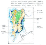
Image:Vegetation map.jpg|India natural vegetation map [http://maps.howstuffworks.com/india-natural-vegetation-map.htm] | Image:Vegetation map.jpg|India natural vegetation map [http://maps.howstuffworks.com/india-natural-vegetation-map.htm] | ||
Revision as of 12:58, 14 December 2012
| Place | Mumbai (Bombay) | |||||||||||
| Country | India | |||||||||||
| Topic | Effects of climate change and adaptation possibilities - case study from Mumbai , India | |||||||||||
| Author(s) | Nisit Chobdamrongtham, Ivankovic Dijana, Milena Ignjatijevic | |||||||||||

| ||||||||||||
| Source | http://www.corfu-fp7.eu/home/page2894.html | |||||||||||
| {{#widget:GoogleMaps | width=300 | height=200 | lat=18.5830 | lng=72.4933 | zoom=5 | centermarker=yes | maptypecontrol=yes | overviewmapcontrol=yes | largemapcontrol=yes | scalecontrol=yes
}} | ||
Rationale: Why have you selected this case study area?
We have selected the area of the city Mumbai,which is the capital city of the Indian state of Maharashtra,because this area is one of the most vulnerable region in the world to climate change. We choose this area, because impacts in India are already being seen in unprecedented heat waves, cyclones, floods, salinisation of the coastline and effects on agriculture, fisheries and health. Challenges of urban poverty in India are intimately tied with challenges of the country’s fast development.Such high-speed, colossal growth, as impressive as it may be, poses several problems if not threats: pollution (air, soil, water), and a disproportionate concentration of poverty, among others.
Authors' perspectives
Whether they are induced by human action or the natural cycle of the planet earth, experts agree on one thing, climate change must be seen as a serious threat to the sustainable development of mankind, with the expected adverse effects to the environment, human health, access to food and natural resources, economic and physical infrastructure. As landscape architects who are closely associated with climate, we should be involved in finding new ways to fight against the consequences of its disruption.
Landscape and/or urban context
Mumbai is the second largest city in the world, and the biggest city in India. It was named a Global City in 2009 and it's most dense megalopolis in the world. Аn increasing number of India’s population are moving to urban centers and now, the average density surpasses 27,000 people per km². It is not unusual that Mumbai’s slums accommodate as many as 100,000 persons per km².
The urban image of Mumbai is one of extremes. On one hand, images of slum dwellers living in substandard conditions are synonymous with the city, yet on the other hand, luxury developments and tall buildings are becoming an increasingly prominent part of the city. These contrasts strongly impact the urban sustainability and economy debate both in local and global discussions. [4]
Historically, Mumbai was formed by land reclamation projects of seven islands which are located on the western coast of India. Mumbai is surrounding with the Arabian Sea. Many parts of the city stand around 10 - 15 m above sea level(average elevation is 14 m). Northern Mumbai(Mumbai Suburban District; Salsette Island) is hilly and the highest point is merely 450 m. There are six major lakes that supply water to the city including three small rivers are situated in Borivili National Park, within the city's limits, one supply from the lake is used only for agricultural and industrial purposes. The coastline of the city is indented with numerous creeks and bays. The eastern coast of Mumbai is covered with large mangrove swamps which are fully in biodiversity while the western coast is mostly sandy and rocky. Soil cover in the city area is affected from sandy near to the sea. In the suburbs, the soil cover is mainly alluvium and loam. Furthermore, Mumbai sits on a seismically active zone is classified as a Seismic Zone III region that means it has possibilities to occur an earthquake up to 6.5 Richter.[source:India Meteorological Department. Seismic Zoning Map (Map). Retrieved 20 July 2008.]
Mumbai has traditional prosperity about textile mills and harbor until the 1980s. Then these are now increasingly being replaced by industries employing more skilled labor such as engineering, diamond polishing, healthcare and information technology. Presently, Mumbai is India's city which has the most population and is the financial and commercial capital of the country also serves as an economic hub. Nevertheless, Mumbai still has many unskilled and semi-skilled self-employed citizenry, who primarily earn their livelihood as hawkers, taxi drivers and mechanics.
Mumbai suffers from the major urbanisation problems that are seen in many fast growing cities in developing countries. The outcome are widespread in poverty, unemployment, poor public health, poor civic, low educational standards. With restrictive land, Mumbai residents often settle in cramped, relatively expensive housing, usually far from workplaces and therefore requiring long commutes on crowded mass transit or traffic jam roadways. By forecasting, demographers said Mumbai's people shifts are in keeping with global trends where population expectedly peaks at the initial stages of development and subsequently falls.[5]
Rapid changes in land use and occupational patterns of urban spaces in developing cities bring upfront the conflict between housing requirements and the preservation of green spaces. Mumbai, where 50% of the population lives on 8% of the land while the city has very limited green spaces except for a large urban forest. In the 1990s, settlements grew within the forest and led one environmental association to file a public interest litigation in order to protect this natural habitat. The analysis is carried out along two main lines. First, it focuses on the impact of urban governance disfunctioning on the peripheries of Indian cities. It demonstrates that peri-urban areas are used as a land reserve fund for relocation programs in order to relegate the poor outside the city central areas. Second, it explores the manner in which the relationships between the poor and the environment are framed on the conservative premises that poor encroachers were mostly responsible for the degradation of the park. Overall, the conflict underscores the constant vulnerability of the urban poor as well as their ability to challenge collectively unfavourable urban policies. New and apparently legitimate forms of urban governance, in our case the judiciary, maintain social prejudices and contribute to displace the poor to the periphery.
The urban or built-up area lay down plain land almost 70% of land area along surround hilly reserved zone as green zonal area, green area is 25% of land area the other shall be blue area which include wetland and coastal forest about less than 5% of total land area
                     Ratio of green : blue  =  5 : 1
                     Ratio of sealed : built-up = 2.3 : 1
[source:Regional Plan for Mumbai Metropolitan Area 1996-2011/Mumbai/Bombay pages]
[source:Environment&Urbanization Copyright 2007 International Institute for Environment and Development (IIED)]
Illustrations:
-
![The illustration above shows Mumbai's region in history[1]](/images/thumb/d/d0/Seven_Islands_of_Bombay.png/87px-Seven_Islands_of_Bombay.png) The illustration above shows Mumbai's region in history[1]
The illustration above shows Mumbai's region in history[1] -
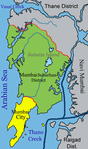 The illustration above shows Mumbai's region in present.
 -
![India natural vegetation map [2]](/images/thumb/3/34/Vegetation_map.jpg/150px-Vegetation_map.jpg) India natural vegetation map [2]
India natural vegetation map [2] -
![The illustration above shows the statistic graph of Mumbai's population in history.[3]](/images/thumb/b/bf/Mumbai4.png/150px-Mumbai4.png) The illustration above shows the statistic graph of Mumbai's population in history.[3]
The illustration above shows the statistic graph of Mumbai's population in history.[3] -
 The illustration above shows Mumbai's zoning area.
 -
 The illustration above shows Mumbai's Land use.
![The illustration above shows Mumbai's region in history[1]](/index.php?title=File:Seven_Islands_of_Bombay.png)

![India natural vegetation map [2]](/index.php?title=File:Vegetation_map.jpg)
![The illustration above shows the statistic graph of Mumbai's population in history.[3]](/index.php?title=File:Mumbai4.png)


![[1]](http://en.wikipedia.org/wiki/File:Seven_Islands_of_Bombay_en.svg.Seven_Islands_of_Bombay)
Cultural/social/political context
- Brief explanation of culture, political economy, legal framework
Illustration: Bullet points, image, background notes
Local Climate
- What are the climatic conditions at present? Have there been extreme weather events in the near past?
- Which changes are expected? Is there any evidence?
Illustration: Table or time line
Analysis of vulnerability
- If you consider these potential changes - which aspects/functions of your case study would be affected?
Illustration: Map/diagram/sketches/photos/background notes
Proposals for Climate Change Adaption
- How could your case study area become more resilient to climate change?
- Which measures would need to be taken to adapt to the new situation?
- How could you assure sustainability of these measures?
- Please describe 2-3 measures
Proposals for Climate Change Mitigation
- Which measures would need to be taken to reduce greenhouse gas emissions and other drivers of climate change within your case study area?
- How could you assure sustainability of these measures?
- Please describe 2-3 measures
Your scenario
- How will this area look like in 2060?
- Please forecast one potential future development taking climate change into account
Illustration: Map/diagram/sketches photos and background notes
What can be generalized from this case study?
- Are there any important theoretical insights?
- Which research questions does it generate?
- Short statement plus background notes
Image Gallery
-
your image text
-
your image text
-
your image text
-
your image text
-
your image text
-
your image text
-
your image text
-
your image text
References
Please add literature, documentations and weblinks
About categories: You can add more categories with this tag: "", add your categories